307:
240:
190:
232:
182:
406:
254:
204:
275:
313:
318:
72:
899:"}},"text\/plain":{"en":{"":"heading"}}},"{\"value\":{\"amount\":\"+292\",\"unit\":\"http:\\\/\\\/www.wikidata.org\\\/entity\\\/Q28390\"},\"type\":\"quantity\"}":{"text\/html":{"en":{"P7787":"292
835:"}},"text\/plain":{"en":{"":"heading"}}},"{\"value\":{\"amount\":\"+292\",\"unit\":\"http:\\\/\\\/www.wikidata.org\\\/entity\\\/Q28390\"},\"type\":\"quantity\"}":{"text\/html":{"en":{"P7787":"292
1231:
1201:
831:
173:
1248:== {{int:filedesc}} == {{Information |description={{en|1=Coire a' Chuill Droma Mhoir Looking across the upper part of the coire from high up on the Druim Thollaidh, with the summit of Sgurr an Doire Leathain beyond.}} |date=2002-05-26 |source=From [http:/
43:
365:– You must give appropriate credit, provide a link to the license, and indicate if changes were made. You may do so in any reasonable manner, but not in any way that suggests the licensor endorses you or your use.
83:
51:
414:
896:
832:
431:
126:
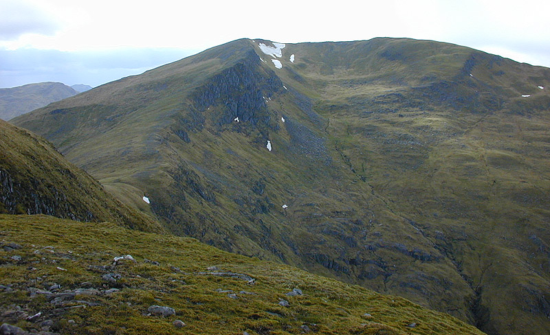
Coire a' Chuill Droma Mhoir
Looking across the upper part of the coire from high up on the Druim Thollaidh, with the summit of Sgurr an Doire Leathain beyond.
1230:
1225:
1034:
767:
697:
661:
247:
197:
1200:
1195:
817:
42:
1475:
282:
1338:
This file contains additional information, probably added from the digital camera or scanner used to create or digitize it.
372:
596:
1444:
1129:
1092:
1055:
1000:
966:
937:
910:
873:
846:
795:
751:
645:
619:
604:
589:
507:
1027:
810:
780:
717:
681:
562:
545:
454:
269:
446:
1211:
328:
1341:
If the file has been modified from its original state, some details may not fully reflect the modified file.
1262:
427:
1258:
The following pages on the
English Knowledge (XXG) use this file (pages on other projects are not listed):
1523:
371:– If you remix, transform, or build upon the material, you must distribute your contributions under the
289:
on the
Geograph website for the photographer's contact details. The copyright on this image is owned by
1241:
325:
903:"}},"text\/plain":{"en":{"P7787":"292 degree"}}}}": -->
839:"}},"text\/plain":{"en":{"P7787":"292 degree"}}}}": -->
1559:
435:
91:
420:
Remove redundant categories and try to put this image in the most specific category/categories
611:
802:
787:
1360:
498:
502:
494:
490:
486:
482:
478:
474:
470:
466:
462:
253:
203:
1541:
1367:
294:
78:
1407:
1577:
135:
1387:
237:
187:
156:
146:
1377:
1305:
274:
1315:
1280:
286:
1290:
1168:
Click on a date/time to view the file as it appeared at that time.
1350:
239:
189:
214:
164:
66:
52:
Coire_a'_Chuill_Droma_Mhoir_-_geograph.org.uk_-_533857.jpg
1300:
116:
Coire a' Chuill Droma Mhoir - geograph.org.uk - 533857.jpg
224:
57° 08′ 06″ N, 5° 16′ 20″ W
174:
57° 07′ 59″ N, 5° 15′ 33″ W
529:
Add a one-line explanation of what this file represents
1325:
434:
combined with a database. You can also have a look at
426:
The location categories are based on information from
110:
90:
Commons is a freely licensed media file repository.
698:
Creative
Commons Attribution-ShareAlike 2.0 Generic
56:(800 × 488 pixels, file size: 175 KB, MIME type:
411:The categories of this image should be checked.
382:https://creativecommons.org/licenses/by-sa/2.0
71:
388:Creative Commons Attribution-Share Alike 2.0
306:
8:
900:
836:
348:– to copy, distribute and transmit the work
1343:
1170:
525:
506:
1273:The following other wikis use this file:
612:https://www.geograph.org.uk/profile/15376
1218:Higher-resolution version from Geograph.
1016:65a5f608cac0677639ddc8aca2a9ed510159e9f7
788:https://www.geograph.org.uk/photo/533857
1601:
1593:
1585:
1575:
1567:
1557:
1549:
1539:
1531:
1521:
1513:
1492:
1484:
1473:
1465:
1457:
1449:
1439:
1431:
1423:
1415:
1404:
1396:
1385:
1375:
1365:
1355:
1260:
1143:
1127:
1106:
1090:
1069:
1053:
1014:
998:
980:
964:
924:
908:
860:
844:
765:
749:
731:
715:
695:
679:
659:
643:
576:
560:
543:
540:
521:
514:
453:This image was uploaded as part of the
217:
167:
246:View this and other nearby images on:
196:View this and other nearby images on:
1345:
441:The topic category from Geograph was
7:
293:and is licensed for reuse under the
1159:
329:Attribution-Share Alike 2.0 Generic
317:
312:
297:Attribution-ShareAlike 2.0 license.
1336:
534:
528:
303:
280:
120:
103:
49:
533:
1398:Date and time of data generation
847:coordinates of the point of view
519:
404:
359:Under the following conditions:
324:This file is licensed under the
316:
311:
305:
273:
252:
238:
230:
202:
188:
180:
70:
31:
21:
516:
121:
46:No higher resolution available.
14:
1372:2/469 sec (0.0042643923240938)
768:file available on the internet
515:
281:This image was taken from the
26:
1:
1598:A directly photographed image
911:coordinates of depicted place
36:
1445:Adobe Photoshop Elements 2.0
818:Geograph Britain and Ireland
590:object of statement has role
541:Items portrayed in this file
229:
179:
1486:Date and time of digitizing
1312:Usage on lld.wikipedia.org
1277:Usage on ceb.wikipedia.org
1623:
1569:Supported Flashpix version
1322:Usage on www.wikidata.org
1297:Usage on de.wikipedia.org
1287:Usage on cy.wikipedia.org
862:57°7'58.94"N, 5°15'33.12"W
373:same or compatible license
1494:Meaning of each component
1451:File change date and time
1160:
926:57°8'5.78"N, 5°16'20.28"W
16:
796:geograph.org.uk image ID
518:
436:this tool from mysociety
402:
401:
339:
77:This is a file from the
1316:Sgurr an Doire Leathain
1306:Sgùrr an Doire Leathain
1291:Sgurr an Doire Leathain
1281:Sgurr an Doire Leathain
1263:Sgurr an Doire Leathain
1247:
1217:
432:this OpenStreetMap tool
152:
141:
134:
131:
113:
81:. Information from its
1515:Image compression mode
1226:19:28, 5 February 2011
287:this photograph's page
258:57.134940; -5.272300
208:57.133040; -5.259200
84:description page there
1533:Maximum land aperture
1425:Horizontal resolution
1196:18:20, 27 August 2017
455:Geograph batch upload
445:(find similar images
1590:Digital still camera
1028:determination method
423:Remove this template
1459:Y and C positioning
1454:00:15, 6 March 2010
1433:Vertical resolution
1347:Camera manufacturer
1213:Geograph Update Bot
499:português do Brasil
354:– to adapt the work
1564:Flash did not fire
1489:16:36, 26 May 2002
1401:16:36, 26 May 2002
620:author name string
428:this geonames tool
1610:
1609:
1536:3.5 APEX (f/3.36)
1269:Global file usage
1251:
902:
838:
682:copyright license
527:
510:
457:
302:
301:
285:collection. See
263:
262:
213:
212:
162:
161:
99:
98:
79:Wikimedia Commons
32:Global file usage
1614:
1467:Exposure Program
1344:
1301:Liste der Munros
1238:
1208:
1148:
1111:
1074:
1037:
1032:
948:
947:
942:
884:
883:
878:
820:
815:
805:
800:
790:
785:
781:described at URL
646:copyright status
627:
624:
614:
609:
599:
594:
511:
452:
409:
408:
407:
395:
392:
389:
386:
383:
375:as the original.
337:
326:Creative Commons
320:
319:
315:
314:
309:
308:
295:Creative Commons
283:Geograph project
277:
270:
259:
256:
242:
241:
235:
234:
233:
227:
226:
215:
209:
206:
192:
191:
185:
184:
183:
177:
176:
165:
137:
125:
117:
111:
95:
74:
73:
67:
61:
59:
1622:
1621:
1617:
1616:
1615:
1613:
1612:
1611:
1332:
1267:
1259:
1252:
1244:
1236:
1214:
1206:
1162:
1161:
1158:
1157:
1156:
1155:
1154:
1153:
1152:
1151:
1149:
1146:
1136:
1135:
1134:
1132:
1121:
1120:
1119:
1118:
1117:
1116:
1115:
1114:
1112:
1109:
1099:
1098:
1097:
1095:
1084:
1083:
1082:
1081:
1080:
1079:
1078:
1077:
1075:
1072:
1062:
1061:
1060:
1058:
1047:
1046:
1045:
1044:
1043:
1042:
1041:
1040:
1039:
1038:
1033:
1030:
1021:
1020:
1019:
1017:
1007:
1006:
1005:
1003:
992:
991:
990:
989:
988:
987:
986:
985:
983:
973:
972:
971:
969:
958:
957:
956:
955:
954:
953:
952:
951:
950:
949:
945:
943:
940:
931:
930:
929:
927:
917:
916:
915:
913:
894:
893:
892:
891:
890:
889:
888:
887:
886:
885:
881:
879:
876:
867:
866:
865:
863:
853:
852:
851:
849:
830:
829:
828:
827:
826:
825:
824:
823:
822:
821:
816:
813:
807:
806:
801:
798:
792:
791:
786:
783:
774:
773:
772:
770:
758:
757:
756:
754:
743:
742:
741:
740:
739:
738:
737:
736:
734:
724:
723:
722:
720:
709:
708:
707:
706:
705:
704:
703:
702:
700:
688:
687:
686:
684:
673:
672:
671:
670:
669:
668:
667:
666:
664:
652:
651:
650:
648:
637:
636:
635:
634:
633:
632:
631:
630:
629:
628:
625:
622:
616:
615:
610:
607:
601:
600:
595:
592:
583:
582:
581:
579:
569:
568:
567:
565:
554:
553:
552:
551:
550:
548:
532:
531:
530:
513:
461:
458:
415:Check them now!
405:
403:
397:
396:
393:
390:
387:
384:
381:
380:
338:
335:
332:
321:
298:
268:
257:
231:
222:
221:
218:Object location
207:
181:
172:
171:
168:Camera location
163:
147:geograph.org.uk
127:
115:
108:
101:
100:
89:
88:
87:is shown below.
63:
57:
55:
48:
47:
12:
11:
5:
1620:
1618:
1608:
1607:
1604:
1600:
1599:
1596:
1592:
1591:
1588:
1584:
1583:
1580:
1574:
1573:
1570:
1566:
1565:
1562:
1556:
1555:
1552:
1548:
1547:
1544:
1538:
1537:
1534:
1530:
1529:
1526:
1520:
1519:
1516:
1512:
1511:
1510:
1509:
1508:does not exist
1506:
1503:
1500:
1495:
1491:
1490:
1487:
1483:
1482:
1479:
1472:
1471:
1470:Normal program
1468:
1464:
1463:
1460:
1456:
1455:
1452:
1448:
1447:
1442:
1438:
1437:
1434:
1430:
1429:
1426:
1422:
1421:
1418:
1414:
1413:
1410:
1403:
1402:
1399:
1395:
1394:
1391:
1384:
1383:
1380:
1374:
1373:
1370:
1364:
1363:
1358:
1354:
1353:
1348:
1335:
1331:
1330:
1329:
1328:
1320:
1319:
1318:
1310:
1309:
1308:
1303:
1295:
1294:
1293:
1285:
1284:
1283:
1271:
1270:
1266:
1265:
1257:
1256:
1255:
1250:
1249:
1246:
1242:
1239:
1233:
1228:
1223:
1220:
1219:
1216:
1212:
1209:
1203:
1198:
1193:
1189:
1188:
1185:
1182:
1179:
1176:
1173:
1166:
1165:
1150:
1144:
1142:
1141:
1140:
1139:
1138:
1137:
1133:
1128:
1126:
1125:
1124:
1123:
1122:
1113:
1107:
1105:
1104:
1103:
1102:
1101:
1100:
1096:
1091:
1089:
1088:
1087:
1086:
1085:
1076:
1070:
1068:
1067:
1066:
1065:
1064:
1063:
1059:
1054:
1052:
1051:
1050:
1049:
1048:
1026:
1025:
1024:
1023:
1022:
1018:
1015:
1013:
1012:
1011:
1010:
1009:
1008:
1004:
999:
997:
996:
995:
994:
993:
984:
981:
979:
978:
977:
976:
975:
974:
970:
965:
963:
962:
961:
960:
959:
936:
935:
934:
933:
932:
928:
925:
923:
922:
921:
920:
919:
918:
914:
909:
907:
906:
905:
904:
898:
872:
871:
870:
869:
868:
864:
861:
859:
858:
857:
856:
855:
854:
850:
845:
843:
842:
841:
840:
834:
809:
808:
794:
793:
779:
778:
777:
776:
775:
771:
766:
764:
763:
762:
761:
760:
759:
755:
752:source of file
750:
748:
747:
746:
745:
744:
735:
732:
730:
729:
728:
727:
726:
725:
721:
716:
714:
713:
712:
711:
710:
701:
696:
694:
693:
692:
691:
690:
689:
685:
680:
678:
677:
676:
675:
674:
665:
660:
658:
657:
656:
655:
654:
653:
649:
644:
642:
641:
640:
639:
638:
618:
617:
603:
602:
588:
587:
586:
585:
584:
580:
577:
575:
574:
573:
572:
571:
570:
566:
561:
559:
558:
557:
556:
555:
549:
544:
542:
539:
538:
537:
536:
535:
524:
523:
520:
517:
451:
450:
439:
424:
421:
379:
378:
377:
376:
366:
357:
356:
355:
349:
342:You are free:
333:
323:
322:
304:
300:
299:
278:
267:
264:
261:
260:
250:
244:
219:
211:
210:
200:
194:
169:
160:
159:
154:
150:
149:
143:
139:
138:
133:
129:
128:
118:
109:
107:
104:
102:
97:
96:
75:
65:
64:
45:
41:
40:
39:
34:
29:
24:
19:
13:
10:
9:
6:
4:
3:
2:
1619:
1605:
1602:
1597:
1594:
1589:
1586:
1581:
1579:
1576:
1571:
1568:
1563:
1561:
1558:
1553:
1550:
1545:
1543:
1542:Metering mode
1540:
1535:
1532:
1527:
1525:
1524:Exposure bias
1522:
1517:
1514:
1507:
1504:
1501:
1498:
1497:
1496:
1493:
1488:
1485:
1480:
1477:
1474:
1469:
1466:
1461:
1458:
1453:
1450:
1446:
1443:
1441:Software used
1440:
1435:
1432:
1427:
1424:
1419:
1416:
1411:
1409:
1405:
1400:
1397:
1392:
1389:
1386:
1381:
1379:
1376:
1371:
1369:
1368:Exposure time
1366:
1362:
1359:
1356:
1352:
1349:
1346:
1342:
1339:
1333:
1327:
1324:
1323:
1321:
1317:
1314:
1313:
1311:
1307:
1304:
1302:
1299:
1298:
1296:
1292:
1289:
1288:
1286:
1282:
1279:
1278:
1276:
1275:
1274:
1268:
1264:
1261:
1253:
1245:
1240:
1234:
1232:
1229:
1227:
1224:
1222:
1221:
1215:
1210:
1204:
1202:
1199:
1197:
1194:
1191:
1190:
1186:
1183:
1180:
1177:
1174:
1172:
1171:
1169:
1163:
1131:
1094:
1057:
1036:
1029:
1002:
968:
939:
912:
875:
848:
819:
812:
804:
797:
789:
782:
769:
753:
719:
699:
683:
663:
647:
621:
613:
606:
598:
591:
564:
547:
512:
509:
504:
500:
496:
492:
488:
484:
480:
476:
472:
468:
464:
459:
456:
448:
444:
440:
437:
433:
429:
425:
422:
419:
418:
417:
416:
412:
400:
399:
385:CC BY-SA 2.0
374:
370:
367:
364:
361:
360:
358:
353:
350:
347:
344:
343:
341:
340:
334:Attribution:
330:
327:
310:
296:
292:
288:
284:
279:
276:
272:
271:
265:
255:
251:
249:
248:OpenStreetMap
245:
243:
225:
220:
216:
205:
201:
199:
198:OpenStreetMap
195:
193:
175:
170:
166:
158:
155:
151:
148:
144:
140:
130:
124:
119:
112:
105:
93:
86:
85:
80:
76:
69:
68:
62:
53:
44:
38:
35:
33:
30:
28:
25:
23:
20:
18:
15:
1551:Light source
1408:focal length
1357:Camera model
1340:
1337:
1272:
1167:
1164:File history
597:photographer
460:
442:
413:
410:
398:
368:
362:
351:
345:
290:
228:
178:
122:
92:You can help
82:
50:
22:File history
1603:IIM version
1587:File source
1578:Color space
1417:Orientation
1243:GeographBot
733:26 May 2002
662:copyrighted
626:Nigel Brown
447:at Geograph
369:share alike
363:attribution
336:Nigel Brown
291:Nigel Brown
157:Nigel Brown
136:26 May 2002
114:Description
1595:Scene type
1254:File usage
1235:640 × 390
1205:800 × 488
1181:Dimensions
982:image/jpeg
967:media type
578:some value
487:македонски
58:image/jpeg
27:File usage
1388:ISO speed
1326:Q20596819
1178:Thumbnail
1175:Date/Time
1056:data size
718:inception
495:português
266:Licensing
123:English:
1462:Co-sited
1378:F-number
1334:Metadata
1207:(175 KB)
1071:179,608
1001:checksum
811:operator
522:Captions
505: |
501: |
497: |
493: |
489: |
485: |
481: |
477: |
473: |
471:français
469: |
465: |
352:to remix
346:to share
331:license.
37:Metadata
1554:Unknown
1546:Pattern
1478:version
1436:300 dpi
1428:300 dpi
1237:(73 KB)
1192:current
1187:Comment
938:heading
897:heading
874:heading
833:heading
563:creator
546:depicts
526:English
463:English
106:Summary
54:
1420:Normal
1412:7.2 mm
1390:rating
1093:height
946:degree
901:degree
882:degree
837:degree
803:533857
503:Türkçe
491:മലയാളം
483:magyar
475:galego
236:
186:
153:Author
142:Source
1560:Flash
1406:Lens
1382:f/5.5
1351:NIKON
1147:pixel
1130:width
1110:pixel
1035:SHA-1
479:עברית
467:suomi
443:Coire
145:From
1582:sRGB
1476:Exif
1361:E800
1184:User
1145:800
1108:488
1073:byte
944:292
880:292
430:and
394:true
391:true
132:Date
17:File
1481:2.1
1393:100
605:URL
508:+/−
1505:Cr
1502:Cb
1031::
941::
877::
814::
799::
784::
623::
608::
593::
1606:2
1572:1
1528:0
1518:4
1499:Y
449:)
438:.
94:.
60:)
Text is available under the Creative Commons Attribution-ShareAlike License. Additional terms may apply.
_heading:292.00&language=en)
_heading:292.00&language=en)
