43:
369:
398:
146:
489:
160:
404:
1775:
409:
1770:
91:
1106:
1136:
1076:
450:– You must give appropriate credit, provide a link to the license, and indicate if changes were made. You may do so in any reasonable manner, but not in any way that suggests the licensor endorses you or your use.
137:
1677:
1168:
2029:
1955:
1755:
506:
57:
53:
47:
102:
70:
1760:
1153:== Summary == {{Location|42|12|00|N|09|03|00|E|scale:2000000}} <br/> {{Information |Description={{en|Blank physical map of the region of
504:; with no Invariant Sections, no Front-Cover Texts, and no Back-Cover Texts. A copy of the license is included in the section entitled
326:
496:
215:
197:
909:
787:
751:
734:
698:
212:, France, destinée à la géolocalisation, avec limite distincte des départements et arrondissements tels que depuis janvier 2010.
194:, France, for geo-location purpose, with distinct boundaries for departments and arrondissements as they are since January 2010.
153:
1135:
1130:
1105:
1100:
1560:
1495:
2040:
This file contains additional information, probably added from the digital camera or scanner used to create or digitize it.
457:
618:
348:) as the author and distribute the copies and derivative works under the same license(s) that the one(s) stated below. A
1004:
967:
930:
875:
841:
807:
771:
682:
654:
639:
626:
611:
501:
902:
718:
584:
567:
1640:
368:
1885:
1205:
297:
1455:
349:
419:
1490:
2043:
If the file has been modified from its original state, some details may not fully reflect the modified file.
1485:
1275:
646:
222:
Scales: 1:520,000 (precision: 130 m) for the topography; 1:7,420,000 (precision: 1,855 m) for the bathymetry
1730:
1565:
1167:
More than 100 pages use this file. The following list shows the first 100 pages that use this file only. A
1975:
1665:
1660:
1655:
1370:
1355:
1350:
456:– If you remix, transform, or build upon the material, you must distribute your contributions under the
1725:
1980:
1075:
1070:
61:
42:
1190:
1180:
416:
1580:
1310:
1250:
2076:
1550:
1525:
1375:
1365:
1330:
1795:
1715:
1670:
1620:
1600:
1595:
1570:
1515:
1460:
1440:
1430:
1425:
1420:
1390:
1345:
1340:
1320:
1300:
1290:
1225:
1185:
110:
2015:
1615:
1315:
1305:
1157:, France, for geo-location purpose, with distinct boundaries for departments and arrondissement
1805:
1605:
1555:
1530:
1510:
1480:
1465:
1405:
1395:
1385:
1175:
483:
1865:
1585:
494:
Permission is granted to copy, distribute and/or modify this document under the terms of the
1635:
1610:
1545:
1540:
1435:
1380:
1325:
1230:
1200:
661:
314:
1940:
1625:
1590:
1505:
1475:
1445:
1360:
1295:
280:
Topography : NASA Shuttle Radar
Topography Mission (SRTM3 v.2) (public domain) ;
1970:
1575:
1950:
1695:
1645:
1520:
1500:
1470:
1450:
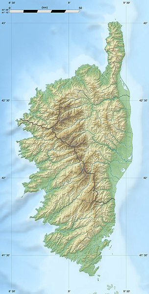
1415:
1410:
1400:
1335:
159:
1860:
1800:
1740:
1650:
1630:
1535:
391:
I, the copyright holder of this work, hereby publish it under the following licenses:
218:
de la carte montre le découpage administratif tel qu'il était jusqu'en décembre 2009.
97:
1820:
1265:
1255:
1235:
1215:
1815:
1785:
2091:
1260:
1245:
1240:
1920:
1270:
1146:
1116:
1086:
1285:
1915:
191:
310:
1845:
1910:
1220:
1210:
1154:
143:
2020:
344:
Any use of this map can be made as long as you credit me (Eric Gaba –
1750:
1280:
289:
1880:
1043:
Click on a date/time to view the file as it appeared at that time.
209:
1870:
200:
of the map shows the boundaries as they were until
December 2009.
1195:
145:
1995:
1990:
2005:
800:
128:
85:
1875:
2010:
345:
2000:
1855:
138:
42° 12′ 00″ N, 9° 03′ 00″ E
1835:
1830:
352:
with a reply address would also be greatly appreciated.
1925:
1905:
551:
Add a one-line explanation of what this file represents
1866:
Knowledge (XXG):Kartenwerkstatt/Positionskarten/Europa
1935:
1705:
1981:
Vikipedio:Lua/Moduloj/Geografiaĵoj/testoj/mapligilo2
1965:
1840:
752:
Creative
Commons Attribution-ShareAlike 3.0 Unported
735:
500:, Version 1.2 or any later version published by the
174:
109:
Commons is a freely licensed media file repository.
1900:
1895:
296:Reference for the 2010 arrondissements boundaries:
75:(824 × 1,625 pixels, file size: 324 KB, MIME type:
1976:Helpo:Ŝablonoj/Ŝablono por la parametrigo de mapo
1886:Colonie de Goélands d’Audouin d’Aspretto/Ajaccio
1123:Updated arrondissments boundaries of Haute-Corse
1776:মডিউল:অবস্থান মানচিত্র/উপাত্ত/ফ্রান্স কর্স/নথি
1731:Módulu:Mapa de llocalización/datos/Córcega/usu
467:https://creativecommons.org/licenses/by-sa/3.0
284:Bathymetry: NGDC ETOPO1 (public domain) ;
90:
473:Creative Commons Attribution-Share Alike 3.0
397:
8:
433:– to copy, distribute and transmit the work
2045:
1771:মডিউল:অবস্থান মানচিত্র/উপাত্ত/ফ্রান্স কর্স
1726:Módulu:Mapa de llocalización/datos/Córcega
1045:
547:
532:You may select the license of your choice.
333:
2016:Plantilla:Mapa de localización de Córcega
1861:Vorlage:Positionskarte Frankreich Korsika
1696:Vorlage:Positionskarte Frankreich Korsika
1688:The following other wikis use this file:
1741:Vorlog:Positionskarte Frankreich Korsika
891:5492902025f9160ec481fffec7d4ece9b0312cd1
2089:
2081:
2071:
2063:
2055:
2047:
1173:
1018:
1002:
981:
965:
944:
928:
889:
873:
855:
839:
821:
805:
785:
769:
749:
732:
716:
696:
680:
662:http://commons.wikimedia.org/User:Sting
598:
582:
565:
562:
543:
536:
364:
342:
288:Additional reference for confirmation:
224:Equirectangular projection, WGS84 datum
131:
1971:Ŝablono:Situo sur mapo Francio Korsiko
1796:Mòdul:Location map/data/França Còrsega
152:View this and other nearby images on:
1821:Plantilya:Location map France Corsica
7:
512:http://www.gnu.org/copyleft/fdl.html
420:Attribution-Share Alike 3.0 Unported
338:Attribution and Share-Alike required
190:Blank physical map of the region of
180:Corse region relief location map.jpg
1956:Πρότυπο:Location map Γαλλία Κορσική
1816:Plantilya:Location map France Corse
1034:
408:
403:
208:Carte physique vierge de la région
2038:
1941:Pśedłoga:LocMap Francojska Korsika
1806:Mòdul:Location map/data/Còrsega/ús
556:
550:
531:
394:
390:
202:
184:
122:
68:
1921:Modul:Location map data fr-h/Doku
555:
1716:قالب:Location map France Corsica
1561:Torra di l'Isula di Gargali
808:coordinates of the point of view
541:
488:
487:
444:Under the following conditions:
415:This file is licensed under the
407:
402:
396:
367:
158:
144:
89:
31:
21:
1801:Mòdul:Location map/data/Còrsega
1786:Šablon:Lokacijska karta Korzika
538:
298:Arrêté préfectoral n° 2009-1508
185:
14:
1496:Torra di Santa Maria Chjapella
537:
518:GNU Free Documentation License
507:GNU Free Documentation License
497:GNU Free Documentation License
233:True scale parallel: 42° 12' N
203:
26:
1:
788:original creation by uploader
374:Equivalent administrative map
346:Wikimedia Commons user: Sting
238:Geographic limits of the map:
229:Standard meridian: 009° 03' E
36:
1916:Modul:Location map data fr-h
612:object of statement has role
563:Items portrayed in this file
335:
1932:Usage on dsb.wikipedia.org
1892:Usage on de.wikivoyage.org
1812:Usage on ceb.wikipedia.org
1737:Usage on bar.wikipedia.org
1722:Usage on ast.wikipedia.org
1702:Usage on ang.wikipedia.org
1692:Usage on als.wikipedia.org
2113:
1987:Usage on es.wikipedia.org
1962:Usage on eo.wikipedia.org
1947:Usage on el.wikipedia.org
1852:Usage on de.wikipedia.org
1827:Usage on cs.wikipedia.org
1792:Usage on ca.wikipedia.org
1782:Usage on bs.wikipedia.org
1767:Usage on bn.wikipedia.org
1747:Usage on bg.wikipedia.org
1712:Usage on ar.wikipedia.org
1456:Torra di Punta d'Arcu
823:42°12'0.000"N, 9°3'0.000"E
458:same or compatible license
2083:File change date and time
2021:Macizo del monte Incudine
1756:Шаблон:ПК Франция Корсика
1641:Tour de L'Île-Rousse
1491:Torra di Sant'Amanza
1206:Col de la Croix (Corsica)
1035:
274:
265:2008-08, modified 02-2010
16:
1566:Torra di l'Isuledda
540:
502:Free Software Foundation
424:
96:This is a file from the
1486:Torra di San Pellegrinu
1276:Scandola Nature Reserve
1152:
1122:
1101:18:33, 22 February 2010
1092:
360:
321:
305:
269:
264:
261:
177:
100:. Information from its
1846:Šablona:LocMap Korsika
164:42.200000; 9.050000
103:description page there
46:Size of this preview:
2057:Horizontal resolution
1666:Tower of San Ciprianu
1661:Tower of Capu di Muru
1656:Tour de San Benedettu
1581:Tour d'Erbalunga
1371:Torra di Finochjarola
1356:Torra di Castelluchju
1351:Torra di Capu di Fenu
1311:Torra d'Asprettu
1251:Lac de l'Oriente
1131:19:50, 14 August 2008
1871:Aiguilles de Bavella
1571:Torra di l'Osse
1321:Torra d'Orchinu
1301:Torra d'Alistru
1291:Torra d'Agnellu
1191:Cantone Grossu Tower
1181:Aiguilles de Bavella
903:determination method
2086:10:49, 18 July 2010
2077:Adobe Photoshop 7.0
2065:Vertical resolution
1761:Виджанело (Франция)
1551:Torra di a Castagna
1526:Torra di Sponsaglia
1376:Torra di Fiurentina
1366:Torra di Ferringule
1331:Torra di Caldarellu
1316:Torra d'Omigna
1306:Torra d'Ancone
1071:13:50, 18 July 2010
439:– to adapt the work
52:Other resolutions:
1671:Turra di a Calanca
1621:Tour de Castellare
1601:Tour de Capigliolo
1596:Tour de Capannella
1586:Tour d'Olmeto
1516:Torra di Solenzara
1461:Torra di Roccapina
1441:Torra di Pinareddu
1431:Torra di Petranera
1426:Torra di Pelusella
1421:Torra di Padulella
1391:Torra di Grisgione
1346:Torra di Capu Neru
1341:Torra di Campumoru
1226:Lac de Bettaniella
1186:Calanques de Piana
640:Wikimedia username
627:author name string
62:824 × 1,625 pixels
2100:
2099:
2030:more global usage
2006:Golfo de Girolata
1881:Îles Sanguinaires
1684:Global file usage
1606:Tour de Capitello
1556:Torra di a Parata
1511:Torra di Senetosa
1481:Torra di Saleccia
1466:Torra di Roglianu
1406:Torra di Mortella
1396:Torra di Micalona
1386:Torra di Giraglia
1296:Torra d'Albu
1176:Action off Bastia
1160:
719:copyright license
549:
529:
528:
381:
380:
356:
355:
330:
327:Reusing this file
169:
168:
118:
117:
98:Wikimedia Commons
32:Global file usage
2104:
2046:
1876:Col de Vizzavona
1636:Tour de Girolata
1611:Tour de Capriona
1576:Tour d'Elbo
1546:Torra di Vignale
1541:Torra di Turghju
1436:Torra di Pianosa
1381:Torra di Galeria
1326:Torra di Caldanu
1231:Lac de Capitellu
1201:Col de Vizzavona
1143:
1113:
1083:
1023:
986:
949:
912:
907:
683:copyright status
664:
659:
649:
644:
634:
631:
621:
616:
525:
522:
519:
516:
513:
491:
490:
484:
480:
477:
474:
471:
468:
460:as the original.
417:Creative Commons
411:
410:
406:
405:
400:
399:
371:
334:
324:
276:
255:South: 41° 15' N
251:North: 43° 09' N
247:East: 009° 42' E
243:West: 008° 24' E
216:ancienne version
207:
205:Français :
189:
181:
175:
165:
162:
148:
147:
141:
140:
129:
114:
93:
92:
86:
80:
78:
65:
58:243 × 480 pixels
54:121 × 240 pixels
48:304 × 600 pixels
2112:
2111:
2107:
2106:
2105:
2103:
2102:
2101:
2034:
2011:Isla de Cavallo
1682:
1626:Tour de Centuri
1616:Tour de Cargèse
1591:Tour de Bravone
1506:Torra di Seneca
1476:Torra di Sagone
1446:Torra di Poghju
1361:Torra di Fautea
1161:
1149:
1141:
1119:
1111:
1089:
1081:
1037:
1036:
1033:
1032:
1031:
1030:
1029:
1028:
1027:
1026:
1024:
1021:
1011:
1010:
1009:
1007:
996:
995:
994:
993:
992:
991:
990:
989:
987:
984:
974:
973:
972:
970:
959:
958:
957:
956:
955:
954:
953:
952:
950:
947:
937:
936:
935:
933:
922:
921:
920:
919:
918:
917:
916:
915:
914:
913:
908:
905:
896:
895:
894:
892:
882:
881:
880:
878:
867:
866:
865:
864:
863:
862:
861:
860:
858:
848:
847:
846:
844:
833:
832:
831:
830:
829:
828:
827:
826:
824:
814:
813:
812:
810:
799:
798:
797:
796:
795:
794:
793:
792:
790:
778:
777:
776:
774:
763:
762:
761:
760:
759:
758:
757:
756:
754:
743:
742:
741:
740:
739:
737:
725:
724:
723:
721:
710:
709:
708:
707:
706:
705:
704:
703:
701:
689:
688:
687:
685:
674:
673:
672:
671:
670:
669:
668:
667:
666:
665:
660:
657:
651:
650:
645:
642:
636:
635:
632:
629:
623:
622:
617:
614:
605:
604:
603:
601:
591:
590:
589:
587:
576:
575:
574:
573:
572:
570:
554:
553:
552:
535:
534:
533:
523:
520:
517:
514:
511:
482:
481:
478:
475:
472:
469:
466:
465:
423:
412:
393:
392:
387:
382:
375:
372:
219:
201:
179:
163:
136:
135:
132:Camera location
127:
120:
119:
108:
107:
106:is shown below.
82:
76:
74:
67:
66:
51:
12:
11:
5:
2110:
2108:
2098:
2097:
2094:
2088:
2087:
2084:
2080:
2079:
2074:
2070:
2069:
2066:
2062:
2061:
2058:
2054:
2053:
2050:
2037:
2032:of this file.
2026:
2025:
2024:
2023:
2018:
2013:
2008:
2003:
2001:Golfo de Porto
1998:
1993:
1985:
1984:
1983:
1978:
1973:
1968:
1960:
1959:
1958:
1953:
1945:
1944:
1943:
1938:
1930:
1929:
1928:
1923:
1918:
1913:
1908:
1903:
1898:
1890:
1889:
1888:
1883:
1878:
1873:
1868:
1863:
1858:
1850:
1849:
1848:
1843:
1838:
1833:
1825:
1824:
1823:
1818:
1810:
1809:
1808:
1803:
1798:
1790:
1789:
1788:
1780:
1779:
1778:
1773:
1765:
1764:
1763:
1758:
1753:
1745:
1744:
1743:
1735:
1734:
1733:
1728:
1720:
1719:
1718:
1710:
1709:
1708:
1700:
1699:
1698:
1686:
1685:
1680:to this file.
1674:
1673:
1668:
1663:
1658:
1653:
1648:
1646:Tour de Lozari
1643:
1638:
1633:
1628:
1623:
1618:
1613:
1608:
1603:
1598:
1593:
1588:
1583:
1578:
1573:
1568:
1563:
1558:
1553:
1548:
1543:
1538:
1533:
1531:Torra di Tizzà
1528:
1523:
1521:Torra di Spanu
1518:
1513:
1508:
1503:
1501:Torra di Scalu
1498:
1493:
1488:
1483:
1478:
1473:
1471:Torra di Sacru
1468:
1463:
1458:
1453:
1451:Torra di Portu
1448:
1443:
1438:
1433:
1428:
1423:
1418:
1416:Torra di Nonza
1413:
1411:Torra di Negru
1408:
1403:
1401:Torra di Miomu
1398:
1393:
1388:
1383:
1378:
1373:
1368:
1363:
1358:
1353:
1348:
1343:
1338:
1336:Torra di Calvi
1333:
1328:
1323:
1318:
1313:
1308:
1303:
1298:
1293:
1288:
1283:
1278:
1273:
1268:
1263:
1258:
1253:
1248:
1243:
1238:
1233:
1228:
1223:
1218:
1213:
1208:
1203:
1198:
1193:
1188:
1183:
1178:
1171:is available.
1165:
1164:
1159:
1158:
1151:
1147:
1144:
1138:
1133:
1128:
1125:
1124:
1121:
1117:
1114:
1108:
1103:
1098:
1095:
1094:
1091:
1087:
1084:
1078:
1073:
1068:
1064:
1063:
1060:
1057:
1054:
1051:
1048:
1041:
1040:
1025:
1019:
1017:
1016:
1015:
1014:
1013:
1012:
1008:
1003:
1001:
1000:
999:
998:
997:
988:
982:
980:
979:
978:
977:
976:
975:
971:
966:
964:
963:
962:
961:
960:
951:
945:
943:
942:
941:
940:
939:
938:
934:
929:
927:
926:
925:
924:
923:
901:
900:
899:
898:
897:
893:
890:
888:
887:
886:
885:
884:
883:
879:
874:
872:
871:
870:
869:
868:
859:
856:
854:
853:
852:
851:
850:
849:
845:
840:
838:
837:
836:
835:
834:
825:
822:
820:
819:
818:
817:
816:
815:
811:
806:
804:
803:
802:
801:
791:
786:
784:
783:
782:
781:
780:
779:
775:
772:source of file
770:
768:
767:
766:
765:
764:
755:
750:
748:
747:
746:
745:
744:
738:
733:
731:
730:
729:
728:
727:
726:
722:
717:
715:
714:
713:
712:
711:
702:
697:
695:
694:
693:
692:
691:
690:
686:
681:
679:
678:
677:
676:
675:
653:
652:
638:
637:
625:
624:
610:
609:
608:
607:
606:
602:
599:
597:
596:
595:
594:
593:
592:
588:
583:
581:
580:
579:
578:
577:
571:
566:
564:
561:
560:
559:
558:
557:
546:
545:
542:
539:
530:
527:
526:
492:
464:
463:
462:
461:
451:
442:
441:
440:
434:
427:You are free:
414:
413:
395:
389:
388:
386:
383:
379:
378:
377:
376:
373:
366:
362:
361:Other versions
358:
357:
354:
353:
341:
340:
331:
319:
318:
307:
303:
302:
301:
300:
294:
286:
282:
271:
267:
266:
263:
259:
258:
257:
256:
253:
249:
245:
236:
235:
231:
198:former version
182:
173:
167:
166:
156:
150:
133:
126:
123:
121:
116:
115:
94:
84:
83:
45:
41:
40:
39:
34:
29:
24:
19:
13:
10:
9:
6:
4:
3:
2:
2109:
2095:
2093:
2090:
2085:
2082:
2078:
2075:
2073:Software used
2072:
2067:
2064:
2059:
2056:
2051:
2048:
2044:
2041:
2035:
2033:
2031:
2022:
2019:
2017:
2014:
2012:
2009:
2007:
2004:
2002:
1999:
1997:
1996:Río Restonica
1994:
1992:
1991:Río Tavignano
1989:
1988:
1986:
1982:
1979:
1977:
1974:
1972:
1969:
1967:
1964:
1963:
1961:
1957:
1954:
1952:
1949:
1948:
1946:
1942:
1939:
1937:
1934:
1933:
1931:
1927:
1924:
1922:
1919:
1917:
1914:
1912:
1909:
1907:
1904:
1902:
1899:
1897:
1894:
1893:
1891:
1887:
1884:
1882:
1879:
1877:
1874:
1872:
1869:
1867:
1864:
1862:
1859:
1857:
1856:Col de Vergio
1854:
1853:
1851:
1847:
1844:
1842:
1839:
1837:
1834:
1832:
1829:
1828:
1826:
1822:
1819:
1817:
1814:
1813:
1811:
1807:
1804:
1802:
1799:
1797:
1794:
1793:
1791:
1787:
1784:
1783:
1781:
1777:
1774:
1772:
1769:
1768:
1766:
1762:
1759:
1757:
1754:
1752:
1749:
1748:
1746:
1742:
1739:
1738:
1736:
1732:
1729:
1727:
1724:
1723:
1721:
1717:
1714:
1713:
1711:
1707:
1704:
1703:
1701:
1697:
1694:
1693:
1691:
1690:
1689:
1683:
1681:
1679:
1672:
1669:
1667:
1664:
1662:
1659:
1657:
1654:
1652:
1651:Tour de Meria
1649:
1647:
1644:
1642:
1639:
1637:
1634:
1632:
1631:Tour de Diana
1629:
1627:
1624:
1622:
1619:
1617:
1614:
1612:
1609:
1607:
1604:
1602:
1599:
1597:
1594:
1592:
1589:
1587:
1584:
1582:
1579:
1577:
1574:
1572:
1569:
1567:
1564:
1562:
1559:
1557:
1554:
1552:
1549:
1547:
1544:
1542:
1539:
1537:
1536:Torra di Toga
1534:
1532:
1529:
1527:
1524:
1522:
1519:
1517:
1514:
1512:
1509:
1507:
1504:
1502:
1499:
1497:
1494:
1492:
1489:
1487:
1484:
1482:
1479:
1477:
1474:
1472:
1469:
1467:
1464:
1462:
1459:
1457:
1454:
1452:
1449:
1447:
1444:
1442:
1439:
1437:
1434:
1432:
1429:
1427:
1424:
1422:
1419:
1417:
1414:
1412:
1409:
1407:
1404:
1402:
1399:
1397:
1394:
1392:
1389:
1387:
1384:
1382:
1379:
1377:
1374:
1372:
1369:
1367:
1364:
1362:
1359:
1357:
1354:
1352:
1349:
1347:
1344:
1342:
1339:
1337:
1334:
1332:
1329:
1327:
1324:
1322:
1319:
1317:
1314:
1312:
1309:
1307:
1304:
1302:
1299:
1297:
1294:
1292:
1289:
1287:
1284:
1282:
1279:
1277:
1274:
1272:
1269:
1267:
1264:
1262:
1259:
1257:
1254:
1252:
1249:
1247:
1244:
1242:
1239:
1237:
1234:
1232:
1229:
1227:
1224:
1222:
1219:
1217:
1214:
1212:
1209:
1207:
1204:
1202:
1199:
1197:
1194:
1192:
1189:
1187:
1184:
1182:
1179:
1177:
1174:
1172:
1170:
1162:
1156:
1150:
1145:
1139:
1137:
1134:
1132:
1129:
1127:
1126:
1120:
1115:
1109:
1107:
1104:
1102:
1099:
1097:
1096:
1093:Color profile
1090:
1085:
1079:
1077:
1074:
1072:
1069:
1066:
1065:
1061:
1058:
1055:
1052:
1049:
1047:
1046:
1044:
1038:
1006:
969:
932:
911:
904:
877:
843:
809:
789:
773:
753:
736:
720:
700:
684:
663:
656:
648:
641:
628:
620:
613:
586:
569:
509:
508:
503:
499:
498:
493:
486:
485:
470:CC BY-SA 3.0
459:
455:
452:
449:
446:
445:
443:
438:
435:
432:
429:
428:
426:
425:
421:
418:
401:
384:
370:
365:
363:
359:
351:
347:
343:
339:
336:
332:
328:
323:
320:
316:
312:
308:
304:
299:
295:
293:
291:
287:
285:
283:
281:
279:
278:
277:
272:
268:
260:
254:
252:
250:
248:
246:
244:
242:
241:
240:
239:
234:
232:
230:
228:
227:
226:
225:
223:
220:
217:
213:
211:
206:
199:
195:
193:
188:
183:
176:
172:
171:
161:
157:
155:
154:OpenStreetMap
151:
149:
139:
134:
130:
124:
112:
105:
104:
99:
95:
88:
87:
81:
72:
71:Original file
63:
59:
55:
49:
44:
38:
35:
33:
30:
28:
25:
23:
20:
18:
15:
2096:Uncalibrated
2042:
2039:
2027:
1911:L’Île-Rousse
1687:
1675:
1266:Monte Grosso
1256:Lac du Cinto
1236:Lac de Goria
1216:Golo (river)
1166:
1140:824 × 1,625
1110:824 × 1,625
1080:824 × 1,625
1042:
1039:File history
619:photographer
505:
495:
453:
447:
436:
430:
337:
273:
237:
221:
204:
186:
170:
111:You can help
101:
69:
22:File history
2092:Color space
2049:Orientation
1836:Monte Cinto
1831:Paglia Orba
1261:Monte Cinto
1246:Lac de Nino
1241:Lac de Melu
699:copyrighted
454:share alike
448:attribution
309:Eric Gaba (
178:Description
1678:more links
1271:San Parteo
1163:File usage
1056:Dimensions
857:image/jpeg
842:media type
600:some value
322:Permission
290:Géoportail
77:image/jpeg
27:File usage
1926:Propriano
1906:Bonifacio
1286:Tavignano
1169:full list
1053:Thumbnail
1050:Date/Time
931:data size
385:Licensing
187:English:
2036:Metadata
1142:(315 KB)
1112:(317 KB)
1082:(324 KB)
946:331,483
876:checksum
544:Captions
437:to remix
431:to share
422:license.
315:fr:Sting
275:Own work
37:Metadata
1966:Korsiko
1951:Κορσική
1936:Korsika
1841:Bavella
1706:Corsica
1221:Gravona
1211:Corsica
1155:Corsica
1067:current
1062:Comment
585:creator
568:depicts
548:English
350:message
192:Corsica
125:Summary
73:
2068:72 dpi
2060:72 dpi
2052:Normal
1281:Taravo
983:1,625
968:height
306:Author
270:Source
142:
2028:View
1901:Calvi
1896:Corte
1676:View
1148:Sting
1118:Sting
1088:Sting
1022:pixel
1005:width
985:pixel
910:SHA-1
647:Sting
633:Sting
311:Sting
210:Corse
1751:Аячо
1196:Cavu
1059:User
1020:824
948:byte
524:true
521:true
515:GFDL
479:true
476:true
262:Date
196:The
17:File
655:URL
906::
658::
643::
630::
615::
313:-
214:L'
60:|
56:|
50:.
510:.
329:)
325:(
317:)
292:.
113:.
79:)
64:.
Text is available under the Creative Commons Attribution-ShareAlike License. Additional terms may apply.

