297:
230:
244:
265:
303:
308:
110:
72:
1036:
355:– You must give appropriate credit, provide a link to the license, and indicate if changes were made. You may do so in any reasonable manner, but not in any way that suggests the licensor endorses you or your use.
43:
221:
1076:
199:
83:
51:
869:
781:
626:
590:
554:
435:
237:
661:
1244:
1213:
272:
1117:
This file contains additional information, probably added from the digital camera or scanner used to create or digitize it.
362:
489:
964:
927:
890:
835:
801:
765:
731:
639:
610:
538:
510:
497:
482:
862:
697:
669:
654:
574:
455:
419:
122:
259:
1046:
318:
1120:
If the file has been modified from its original state, some details may not fully reflect the modified file.
154:
1071:
1067:
The following pages on the
English Knowledge (XXG) use this file (pages on other projects are not listed):
1054:
1318:
361:– If you remix, transform, or build upon the material, you must distribute your contributions under the
279:
on the
Geograph website for the photographer's contact details. The copyright on this image is owned by
315:
1346:
91:
1035:
1030:
42:
117:
1139:
1057:, Powys, Wales at a time of very low water. Photo originally submitted to and taken by on
517:
676:
646:
243:
1336:
1292:
284:
78:
1176:
1364:
167:
1156:
227:
188:
178:
1146:
1129:
264:
276:
1094:
1003:
Click on a date/time to view the file as it appeared at that time.
229:
724:
222:
52° 15′ 44.89″ N, 3° 35′ 44.16″ W
212:
109:
66:
403:
Add a one-line explanation of what this file represents
1104:
206:
Creative
Commons Attribution Share-alike license 2.0
137:
104:
90:
Commons is a freely licensed media file repository.
591:
Creative
Commons Attribution-ShareAlike 2.0 Generic
56:(640 × 480 pixels, file size: 141 KB, MIME type:
372:https://creativecommons.org/licenses/by-sa/2.0
71:
378:Creative Commons Attribution-Share Alike 2.0
296:
8:
338:– to copy, distribute and transmit the work
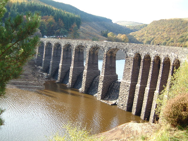
157:, Powys, Wales at a time of very low water.
1122:
1005:
399:
1087:The following other wikis use this file:
159:Maintains minimum level of upstream part.
153:Carreg ddu separating dam at Caban Coch,
851:589c2e3add44abe0dec9eab396cd455e88097eca
518:https://www.geograph.org.uk/profile/1262
1412:
1404:
1396:
1388:
1380:
1372:
1362:
1354:
1344:
1334:
1326:
1316:
1308:
1300:
1290:
1282:
1261:
1253:
1242:
1234:
1226:
1218:
1214:Digital Camera FinePix4700 ZOOM Ver1.00
1208:
1200:
1192:
1184:
1173:
1165:
1154:
1144:
1134:
1069:
978:
962:
941:
925:
904:
888:
849:
833:
815:
799:
779:
763:
745:
729:
711:
695:
677:https://www.geograph.org.uk/photo/28007
624:
608:
588:
572:
552:
536:
469:
453:
433:
417:
414:
395:
388:
215:
236:View this and other nearby images on:
1124:
7:
436:Carreg Ddu Viaduct And Submerged Dam
283:and is licensed for reuse under the
1077:Grade II* listed buildings in Powys
994:
319:Attribution-Share Alike 2.0 Generic
307:
302:
287:Attribution-ShareAlike 2.0 license.
1115:
408:
402:
293:
270:
147:
115:
103:
49:
407:
1167:Date and time of data generation
732:coordinates of the point of view
393:
349:Under the following conditions:
314:This file is licensed under the
306:
301:
295:
263:
242:
228:
108:
70:
31:
21:
390:
148:
46:No higher resolution available.
14:
1053:Separating dam at Caban Coch,
627:file available on the internet
389:
271:This image was taken from the
26:
1:
1417:A directly photographed image
36:
662:Geograph Britain and Ireland
483:object of statement has role
415:Items portrayed in this file
1390:Focal plane resolution unit
1255:Date and time of digitizing
747:52°15'44.89"N, 3°35'44.16"W
143:Caban Coch, Elan Valley.jpg
52:Caban_Coch,_Elan_Valley.jpg
1434:
1401:One-chip color area sensor
1356:Supported Flashpix version
1101:Usage on www.wikidata.org
1091:Usage on nn.wikipedia.org
363:same or compatible license
1263:Meaning of each component
1220:File change date and time
995:
16:
1382:Focal plane Y resolution
1374:Focal plane X resolution
1055:w:Elan Valley Reservoirs
640:geograph.org.uk image ID
392:
329:
155:w:Elan Valley Reservoirs
77:This is a file from the
1052:
1031:22:19, 3 September 2005
194:
184:
173:
166:
163:
140:
81:. Information from its
1284:Image compression mode
1258:15:05, 25 October 2003
1223:15:05, 25 October 2003
1170:15:05, 25 October 2003
1095:Elan Valley-reservoara
1072:Elan Valley Reservoirs
1048:Loganberry~commonswiki
277:this photograph's page
248:52.262470; -3.595600
84:description page there
1328:Maximum land aperture
1194:Horizontal resolution
1409:Digital still camera
863:determination method
766:location of creation
1228:Y and C positioning
1202:Vertical resolution
1126:Camera manufacturer
344:– to adapt the work
116:This is a photo of
1351:Flash did not fire
498:author name string
1421:
1420:
1083:Global file usage
1060:
575:copyright license
401:
292:
291:
275:collection. See
253:
252:
210:
209:
203:
200:Reusing this file
130:
129:
99:
98:
79:Wikimedia Commons
32:Global file usage
1425:
1236:Exposure Program
1140:FinePix4700 ZOOM
1123:
1043:
983:
946:
909:
872:
867:
679:
674:
670:described at URL
664:
659:
649:
644:
539:copyright status
520:
515:
505:
502:
492:
487:
385:
382:
379:
376:
373:
365:as the original.
327:
316:Creative Commons
310:
309:
305:
304:
299:
298:
285:Creative Commons
273:Geograph project
267:
260:
249:
246:
232:
231:
225:
224:
213:
197:
169:
152:
144:
138:
112:
105:
95:
74:
73:
67:
61:
59:
1433:
1432:
1428:
1427:
1426:
1424:
1423:
1422:
1331:3 APEX (f/2.83)
1310:APEX brightness
1111:
1081:
1068:
1061:
1049:
1041:
997:
996:
993:
992:
991:
990:
989:
988:
987:
986:
984:
981:
971:
970:
969:
967:
956:
955:
954:
953:
952:
951:
950:
949:
947:
944:
934:
933:
932:
930:
919:
918:
917:
916:
915:
914:
913:
912:
910:
907:
897:
896:
895:
893:
882:
881:
880:
879:
878:
877:
876:
875:
874:
873:
868:
865:
856:
855:
854:
852:
842:
841:
840:
838:
827:
826:
825:
824:
823:
822:
821:
820:
818:
808:
807:
806:
804:
793:
792:
791:
790:
789:
788:
787:
786:
784:
772:
771:
770:
768:
757:
756:
755:
754:
753:
752:
751:
750:
748:
738:
737:
736:
734:
723:
722:
721:
720:
719:
718:
717:
716:
714:
713:25 October 2003
704:
703:
702:
700:
689:
688:
687:
686:
685:
684:
683:
682:
681:
680:
675:
672:
666:
665:
660:
657:
651:
650:
645:
642:
633:
632:
631:
629:
617:
616:
615:
613:
602:
601:
600:
599:
598:
597:
596:
595:
593:
581:
580:
579:
577:
566:
565:
564:
563:
562:
561:
560:
559:
557:
545:
544:
543:
541:
530:
529:
528:
527:
526:
525:
524:
523:
522:
521:
516:
513:
507:
506:
503:
500:
494:
493:
488:
485:
476:
475:
474:
472:
462:
461:
460:
458:
447:
446:
445:
444:
443:
442:
441:
440:
438:
426:
425:
424:
422:
406:
405:
404:
387:
386:
383:
380:
377:
374:
371:
370:
328:
325:
322:
311:
288:
258:
247:
220:
219:
216:Camera location
211:
179:geograph.org.uk
168:25 October 2003
158:
142:
135:
121:
118:listed building
101:
100:
89:
88:
87:is shown below.
63:
57:
55:
48:
47:
12:
11:
5:
1431:
1429:
1419:
1418:
1415:
1411:
1410:
1407:
1403:
1402:
1399:
1398:Sensing method
1395:
1394:
1391:
1387:
1386:
1383:
1379:
1378:
1375:
1371:
1370:
1367:
1361:
1360:
1357:
1353:
1352:
1349:
1343:
1342:
1339:
1333:
1332:
1329:
1325:
1324:
1321:
1315:
1314:
1311:
1307:
1306:
1303:
1299:
1298:
1295:
1289:
1288:
1285:
1281:
1280:
1279:
1278:
1277:does not exist
1275:
1272:
1269:
1264:
1260:
1259:
1256:
1252:
1251:
1248:
1241:
1240:
1239:Normal program
1237:
1233:
1232:
1229:
1225:
1224:
1221:
1217:
1216:
1211:
1207:
1206:
1203:
1199:
1198:
1195:
1191:
1190:
1187:
1183:
1182:
1179:
1172:
1171:
1168:
1164:
1163:
1160:
1153:
1152:
1149:
1143:
1142:
1137:
1133:
1132:
1127:
1114:
1110:
1109:
1108:
1107:
1099:
1098:
1097:
1085:
1084:
1080:
1079:
1074:
1066:
1065:
1064:
1059:
1058:
1051:
1047:
1044:
1038:
1033:
1028:
1024:
1023:
1020:
1017:
1014:
1011:
1008:
1001:
1000:
985:
979:
977:
976:
975:
974:
973:
972:
968:
963:
961:
960:
959:
958:
957:
948:
942:
940:
939:
938:
937:
936:
935:
931:
926:
924:
923:
922:
921:
920:
911:
905:
903:
902:
901:
900:
899:
898:
894:
889:
887:
886:
885:
884:
883:
861:
860:
859:
858:
857:
853:
850:
848:
847:
846:
845:
844:
843:
839:
834:
832:
831:
830:
829:
828:
819:
816:
814:
813:
812:
811:
810:
809:
805:
800:
798:
797:
796:
795:
794:
785:
780:
778:
777:
776:
775:
774:
773:
769:
764:
762:
761:
760:
759:
758:
749:
746:
744:
743:
742:
741:
740:
739:
735:
730:
728:
727:
726:
725:
715:
712:
710:
709:
708:
707:
706:
705:
701:
696:
694:
693:
692:
691:
690:
668:
667:
653:
652:
638:
637:
636:
635:
634:
630:
625:
623:
622:
621:
620:
619:
618:
614:
611:source of file
609:
607:
606:
605:
604:
603:
594:
589:
587:
586:
585:
584:
583:
582:
578:
573:
571:
570:
569:
568:
567:
558:
553:
551:
550:
549:
548:
547:
546:
542:
537:
535:
534:
533:
532:
531:
509:
508:
496:
495:
481:
480:
479:
478:
477:
473:
470:
468:
467:
466:
465:
464:
463:
459:
454:
452:
451:
450:
449:
448:
439:
434:
432:
431:
430:
429:
428:
427:
423:
418:
416:
413:
412:
411:
410:
409:
398:
397:
394:
391:
369:
368:
367:
366:
356:
347:
346:
345:
339:
332:You are free:
323:
313:
312:
294:
290:
289:
268:
257:
254:
251:
250:
240:
234:
217:
208:
207:
204:
192:
191:
186:
182:
181:
175:
171:
170:
165:
161:
160:
145:
136:
134:
131:
128:
127:
113:
102:
97:
96:
75:
65:
64:
45:
41:
40:
39:
34:
29:
24:
19:
13:
10:
9:
6:
4:
3:
2:
1430:
1416:
1413:
1408:
1405:
1400:
1397:
1392:
1389:
1384:
1381:
1376:
1373:
1368:
1366:
1363:
1358:
1355:
1350:
1348:
1345:
1340:
1338:
1337:Metering mode
1335:
1330:
1327:
1322:
1320:
1319:Exposure bias
1317:
1312:
1309:
1304:
1302:APEX aperture
1301:
1296:
1294:
1293:Shutter speed
1291:
1286:
1283:
1276:
1273:
1270:
1267:
1266:
1265:
1262:
1257:
1254:
1249:
1246:
1243:
1238:
1235:
1230:
1227:
1222:
1219:
1215:
1212:
1210:Software used
1209:
1204:
1201:
1196:
1193:
1188:
1185:
1180:
1178:
1174:
1169:
1166:
1161:
1158:
1155:
1150:
1148:
1145:
1141:
1138:
1135:
1131:
1128:
1125:
1121:
1118:
1112:
1106:
1103:
1102:
1100:
1096:
1093:
1092:
1090:
1089:
1088:
1082:
1078:
1075:
1073:
1070:
1062:
1056:
1050:
1045:
1039:
1037:
1034:
1032:
1029:
1026:
1025:
1021:
1018:
1015:
1012:
1009:
1007:
1006:
1004:
998:
966:
929:
892:
871:
864:
837:
803:
783:
767:
733:
699:
678:
671:
663:
656:
648:
641:
628:
612:
592:
576:
556:
540:
519:
512:
499:
491:
484:
457:
437:
421:
375:CC BY-SA 2.0
364:
360:
357:
354:
351:
350:
348:
343:
340:
337:
334:
333:
331:
330:
324:Attribution:
320:
317:
300:
286:
282:
278:
274:
269:
266:
262:
261:
255:
245:
241:
239:
238:OpenStreetMap
235:
233:
223:
218:
214:
205:
201:
196:
193:
190:
187:
183:
180:
176:
172:
162:
156:
151:
146:
139:
132:
126:
124:
119:
114:
111:
107:
106:
93:
86:
85:
80:
76:
69:
68:
62:
53:
44:
38:
35:
33:
30:
28:
25:
23:
20:
18:
15:
1177:focal length
1136:Camera model
1119:
1116:
1086:
1002:
999:File history
490:photographer
358:
352:
341:
335:
280:
149:
92:You can help
82:
50:
22:File history
1406:File source
1365:Color space
1186:Orientation
555:copyrighted
504:colin price
359:share alike
353:attribution
326:colin price
281:colin price
189:colin price
141:Description
1414:Scene type
1063:File usage
1040:640 × 480
1016:Dimensions
817:image/jpeg
802:media type
471:some value
195:Permission
58:image/jpeg
27:File usage
1157:ISO speed
1105:Q17742486
1013:Thumbnail
1010:Date/Time
891:data size
698:inception
256:Licensing
150:English:
1231:Co-sited
1147:F-number
1130:FUJIFILM
1113:Metadata
1042:(141 KB)
906:144,489
836:checksum
782:Rhayader
655:operator
396:Captions
342:to remix
336:to share
321:license.
37:Metadata
1341:Pattern
1247:version
1027:current
1022:Comment
456:creator
420:depicts
400:English
133:Summary
54:
1205:72 dpi
1197:72 dpi
1189:Normal
1181:9.4 mm
1159:rating
928:height
226:
185:Author
174:Source
120:number
1385:2,381
1377:2,381
1347:Flash
1175:Lens
1151:f/2.8
982:pixel
965:width
945:pixel
870:SHA-1
647:28007
177:From
123:16200
1369:sRGB
1313:6.26
1245:Exif
1019:User
980:640
943:480
908:byte
384:true
381:true
164:Date
17:File
1297:8.6
1287:3.2
1250:2.1
1162:200
511:URL
1274:Cr
1271:Cb
866::
673::
658::
643::
514::
501::
486::
1393:3
1359:1
1323:0
1305:3
1268:Y
202:)
198:(
125:.
94:.
60:)
Text is available under the Creative Commons Attribution-ShareAlike License. Additional terms may apply.
