171:
124:
177:
67:
182:
647:
230:– You must give appropriate credit, provide a link to the license, and indicate if changes were made. You may do so in any reasonable manner, but not in any way that suggests the licensor endorses you or your use.
38:
141:
78:
46:
696:
139:; with no Invariant Sections, no Front-Cover Texts, and no Back-Cover Texts. A copy of the license is included in the section entitled
741:
131:
480:
392:
375:
339:
751:
665:
237:
575:
538:
501:
446:
412:
323:
136:
108:
473:
359:
306:
706:
721:
716:
657:
191:
746:
731:
646:
641:
37:
711:
236:– If you remix, transform, or build upon the material, you must distribute your contributions under the
701:
188:
681:
86:
118:
251:
129:
Permission is granted to copy, distribute and/or modify this document under the terms of the
686:
691:
726:
73:
736:
769:
789:
614:
Click on a date/time to view the file as it appeared at that time.
250:
This licensing tag was added to this file as part of the GFDL
165:
61:
779:
664:
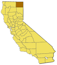
Map of Modoc county in
California. From en: {{GFDL}}
290:
Add a one-line explanation of what this file represents
799:
393:
376:
Creative
Commons Attribution-ShareAlike 3.0 Unported
135:, Version 1.2 or any later version published by the
85:
Commons is a freely licensed media file repository.
51:(200 × 231 pixels, file size: 22 KB, MIME type:
257:http://creativecommons.org/licenses/by-sa/3.0/
66:
170:
8:
263:Creative Commons Attribution-Share Alike 3.0
213:– to copy, distribute and transmit the work
616:
286:
762:The following other wikis use this file:
462:54b1984b67caf8e7536d66103aeec48d53673545
679:
666:Category:Maps of counties in California
589:
573:
552:
536:
515:
499:
460:
444:
426:
410:
390:
373:
357:
337:
321:
304:
301:
282:
275:
47:California_map_showing_Modoc_County.png
677:The following 15 pages use this file:
697:Eagle Peak (Modoc County, California)
7:
192:Attribution-Share Alike 3.0 Unported
147:http://www.gnu.org/copyleft/fdl.html
605:
181:
176:
742:Tule Lake National Wildlife Refuge
295:
289:
98:
44:
294:
280:
224:Under the following conditions:
187:This file is licensed under the
180:
175:
169:
123:
122:
65:
31:
21:
752:Template:ModocCountyCA-geo-stub
277:
41:No higher resolution available.
14:
276:
153:GNU Free Documentation License
142:GNU Free Documentation License
132:GNU Free Documentation License
26:
1:
302:Items portrayed in this file
786:Usage on pam.wikipedia.org
818:
796:Usage on www.wikidata.org
776:Usage on li.wikipedia.org
766:Usage on bg.wikipedia.org
238:same or compatible license
707:Fox Mountain (California)
606:
196:
168:
16:
790:Modoc County, California
722:Keuchishkeni, California
717:Keshlakchuis, California
279:
137:Free Software Foundation
72:This is a file from the
747:White Horse, California
732:Menlo Baths, California
663:
76:. Information from its
79:description page there
712:Hackamore, California
702:Fairport, California
659:Pyramide~commonswiki
474:determination method
682:Chumawi, California
642:13:39, 13 July 2005
219:– to adapt the work
758:Global file usage
670:
360:copyright license
288:
274:
273:
164:
163:
94:
93:
74:Wikimedia Commons
32:Global file usage
809:
687:Clear Lake Hills
654:
594:
557:
520:
483:
478:
324:copyright status
270:
267:
264:
261:
258:
255:
252:licensing update
240:as the original.
189:Creative Commons
184:
183:
179:
178:
173:
172:
166:
160:
157:
154:
151:
148:
126:
125:
119:
112:— in California.
90:
69:
68:
62:
56:
54:
817:
816:
812:
811:
810:
808:
807:
806:
756:
692:Day, California
671:
660:
652:
608:
607:
604:
603:
602:
601:
600:
599:
598:
597:
595:
592:
582:
581:
580:
578:
567:
566:
565:
564:
563:
562:
561:
560:
558:
555:
545:
544:
543:
541:
530:
529:
528:
527:
526:
525:
524:
523:
521:
518:
508:
507:
506:
504:
493:
492:
491:
490:
489:
488:
487:
486:
485:
484:
479:
476:
467:
466:
465:
463:
453:
452:
451:
449:
438:
437:
436:
435:
434:
433:
432:
431:
429:
419:
418:
417:
415:
404:
403:
402:
401:
400:
399:
398:
397:
395:
384:
383:
382:
381:
380:
378:
366:
365:
364:
362:
351:
350:
349:
348:
347:
346:
345:
344:
342:
330:
329:
328:
326:
315:
314:
313:
312:
311:
309:
293:
292:
291:
268:
265:
262:
259:
256:
249:
158:
155:
152:
149:
146:
106:Locator map of
103:
96:
95:
84:
83:
82:is shown below.
58:
52:
50:
43:
42:
12:
11:
5:
815:
813:
805:
804:
803:
802:
794:
793:
792:
784:
783:
782:
774:
773:
772:
760:
759:
755:
754:
749:
744:
739:
734:
729:
727:Larkspur Hills
724:
719:
714:
709:
704:
699:
694:
689:
684:
675:
674:
669:
668:
662:
658:
655:
649:
644:
639:
635:
634:
631:
628:
625:
622:
619:
612:
611:
596:
590:
588:
587:
586:
585:
584:
583:
579:
574:
572:
571:
570:
569:
568:
559:
553:
551:
550:
549:
548:
547:
546:
542:
537:
535:
534:
533:
532:
531:
522:
516:
514:
513:
512:
511:
510:
509:
505:
500:
498:
497:
496:
495:
494:
472:
471:
470:
469:
468:
464:
461:
459:
458:
457:
456:
455:
454:
450:
445:
443:
442:
441:
440:
439:
430:
427:
425:
424:
423:
422:
421:
420:
416:
411:
409:
408:
407:
406:
405:
396:
391:
389:
388:
387:
386:
385:
379:
374:
372:
371:
370:
369:
368:
367:
363:
358:
356:
355:
354:
353:
352:
343:
338:
336:
335:
334:
333:
332:
331:
327:
322:
320:
319:
318:
317:
316:
310:
305:
303:
300:
299:
298:
297:
296:
285:
284:
281:
278:
272:
271:
246:
245:
244:
243:
242:
241:
231:
222:
221:
220:
214:
207:You are free:
202:
201:
198:
197:
195:
185:
162:
161:
127:
114:
113:
102:
99:
97:
92:
91:
70:
60:
59:
40:
36:
35:
34:
29:
24:
19:
13:
10:
9:
6:
4:
3:
2:
814:
801:
798:
797:
795:
791:
788:
787:
785:
781:
778:
777:
775:
771:
768:
767:
765:
764:
763:
757:
753:
750:
748:
745:
743:
740:
738:
735:
733:
730:
728:
725:
723:
720:
718:
715:
713:
710:
708:
705:
703:
700:
698:
695:
693:
690:
688:
685:
683:
680:
678:
672:
667:
661:
656:
650:
648:
645:
643:
640:
637:
636:
632:
629:
626:
623:
620:
618:
617:
615:
609:
577:
540:
503:
482:
475:
448:
414:
394:
377:
361:
341:
325:
308:
253:
248:
247:
239:
235:
232:
229:
226:
225:
223:
218:
215:
212:
209:
208:
206:
205:
204:
203:
200:
199:
193:
190:
186:
174:
167:
144:
143:
138:
134:
133:
128:
121:
120:
117:
116:
111:
110:
105:
104:
100:
88:
81:
80:
75:
71:
64:
63:
57:
48:
39:
33:
30:
28:
25:
23:
20:
18:
15:
780:Modoc County
761:
676:
613:
610:File history
260:CC BY-SA 3.0
233:
227:
216:
210:
140:
130:
115:
109:Modoc County
107:
87:You can help
77:
45:
22:File history
340:copyrighted
234:share alike
228:attribution
673:File usage
651:200 × 231
627:Dimensions
413:media type
27:File usage
800:Q25142386
737:Tule Lake
624:Thumbnail
621:Date/Time
502:data size
428:image/png
194:license.
53:image/png
447:checksum
283:Captions
217:to remix
211:to share
653:(22 KB)
638:current
633:Comment
517:22,776
307:depicts
287:English
101:Summary
49:
539:height
770:Модок
593:pixel
576:width
556:pixel
481:SHA-1
630:User
591:200
554:231
519:byte
269:true
266:true
159:true
156:true
150:GFDL
17:File
477::
254:.
145:.
89:.
55:)
Text is available under the Creative Commons Attribution-ShareAlike License. Additional terms may apply.