38:
242:
248:
253:
94:
738:
300:– You must give appropriate credit, provide a link to the license, and indicate if changes were made. You may do so in any reasonable manner, but not in any way that suggests the licensor endorses you or your use.
759:, UK. Equirectangular map projection on WGS 84 datum, with N/S stretched 160% Geographic limits: *West: 4.75W *East: 3.58W *North: 52.15N *South: 51.58N |Source=[[w:Ordnance S
788:
60:
56:
52:
48:
42:
783:
951:
105:
73:
231:
941:
936:
571:
449:
413:
202:
307:
896:
666:
629:
592:
537:
503:
397:
564:
469:
433:
380:
340:
263:
1016:
737:
732:
64:
37:
778:
769:
The following pages on the
English Knowledge (XXG) use this file (pages on other projects are not listed):
806:
306:– If you remix, transform, or build upon the material, you must distribute your contributions under the
1011:
260:
901:
185:
113:
1031:
1001:
911:
182:
139:
1026:
996:
816:
773:
756:
851:
1051:
1041:
931:
748:
206:
826:
100:
981:
961:
219:
171:
986:
966:
145:
Equirectangular map projection on WGS 84 datum, with N/S stretched 160%
195:
Administrative borders and coastline data from
Boundary-Line product.
897:
Wikiproyecto:Ilustración/Taller de
Cartografía/Realizaciones/Europa
886:
705:
Click on a date/time to view the file as it appeared at that time.
271:
Contains
Ordnance Survey data © Crown copyright and database right
866:
876:
871:
841:
88:
846:
971:
881:
856:
861:
836:
921:
364:
Add a one-line explanation of what this file represents
1017:
916:
78:(1,999 × 1,558 pixels, file size: 428 KB, MIME type:
450:
Creative
Commons Attribution-ShareAlike 3.0 Unported
127:
112:
Commons is a freely licensed media file repository.
1032:Module:Location map/data/Wales Carmarthenshire/doc
1002:Module:Location map/data/Wales Carmarthenshire/doc
789:Module:Location map/data/Wales Carmarthenshire/doc
198:All other geographic data from Meridian 2 product.
942:モジュール:Location map/data/Wales Carmarthenshire/doc
902:Plantilla:Mapa de localización de Carmarthenshire
1012:Modül:Konum haritası/veri/Galler Carmarthenshire
1027:Module:Location map/data/Wales Carmarthenshire
997:Module:Location map/data/Wales Carmarthenshire
784:Module:Location map/data/Wales Carmarthenshire
317:https://creativecommons.org/licenses/by-sa/3.0
93:
937:モジュール:Location map/data/Wales Carmarthenshire
323:Creative Commons Attribution-Share Alike 3.0
241:
8:
952:ಟೆಂಪ್ಲೇಟು:Location map Wales Carmarthenshire
852:Vorlage:Positionskarte Wales Carmarthenshire
817:Plantilya:Location map Wales Carmarthenshire
192:Relief data from Land-Form Panorama product.
1052:Template:Location map Wales Carmarthenshire
932:Template:Location map Wales Carmarthenshire
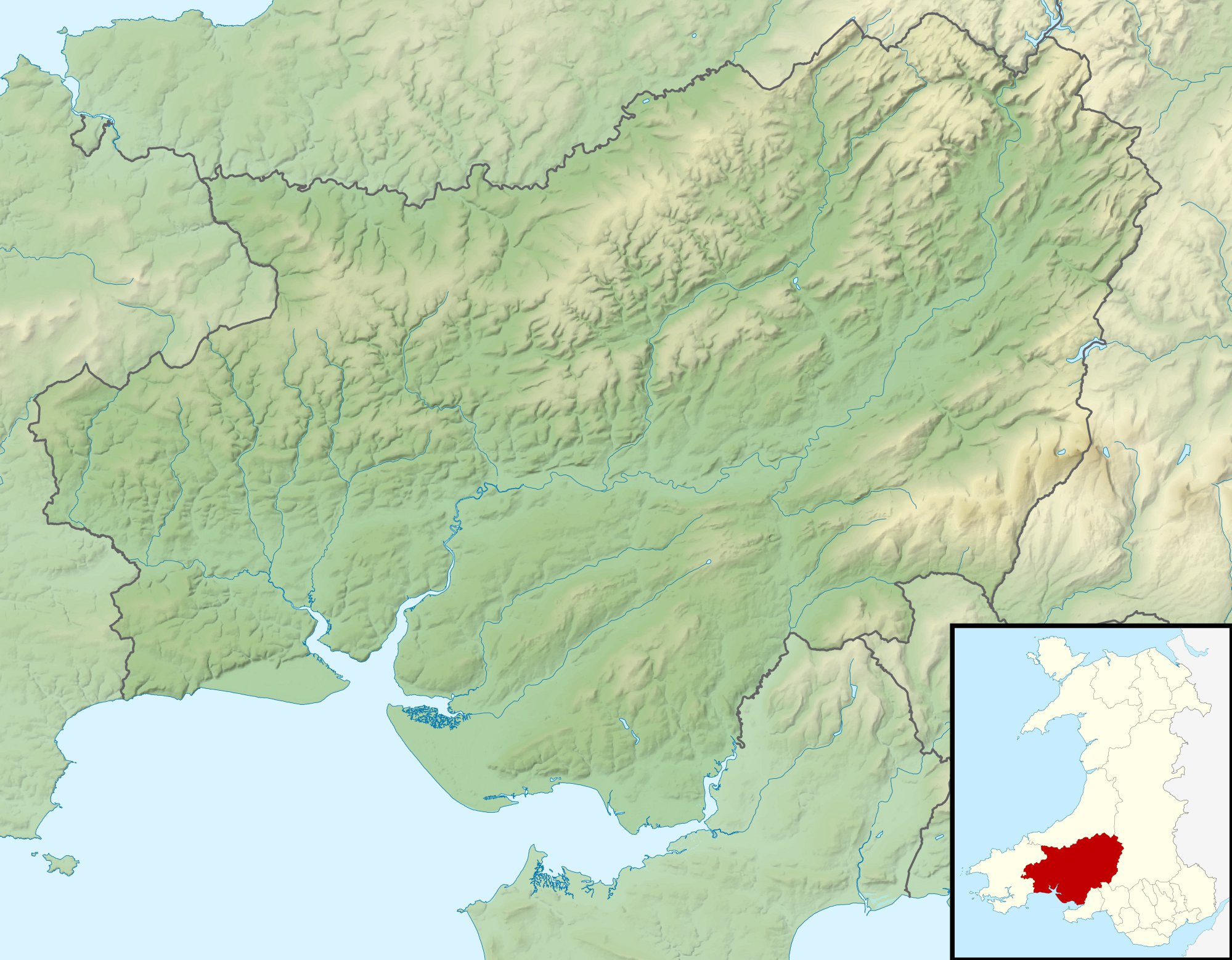
283:– to copy, distribute and transmit the work
1042:Batakan:Location map Wales Carmarthenshire
707:
360:
133:Carmarthenshire UK relief location map.jpg
799:The following other wikis use this file:
755:{{Information |Description=Relief map of
827:Nodyn:Location map Wales Carmarthenshire
553:c608fed785117767233030b1cbf57e7c58870b1f
807:قالب:Location map Wales Carmarthenshire
771:
680:
664:
643:
627:
606:
590:
551:
535:
517:
501:
483:
467:
447:
431:
411:
395:
378:
375:
356:
349:
912:Modèle:Géolocalisation/Carmarthenshire
203:File: United Kingdom location map.svg
7:
264:Attribution-Share Alike 3.0 Unported
222:, created using Ordnance Survey data
696:
252:
247:
369:
363:
238:
125:
71:
368:
354:
294:Under the following conditions:
259:This file is licensed under the
251:
246:
240:
201:Inset derived from derived from
92:
31:
21:
982:Moduł:Mapa/dane/Carmarthenshire
962:Moduł:Mapa/dane/Carmarthenshire
351:
341:File:Carmarthenshire UK map.svg
14:
350:
26:
1:
376:Items portrayed in this file
1038:Usage on war.wikipedia.org
813:Usage on ceb.wikipedia.org
1070:
1048:Usage on zh.wikipedia.org
1023:Usage on uz.wikipedia.org
1008:Usage on tr.wikipedia.org
993:Usage on si.wikipedia.org
978:Usage on pl.wikibooks.org
958:Usage on pl.wikipedia.org
948:Usage on kn.wikipedia.org
928:Usage on ja.wikipedia.org
908:Usage on fr.wikipedia.org
893:Usage on es.wikipedia.org
833:Usage on de.wikipedia.org
823:Usage on cy.wikipedia.org
803:Usage on ar.wikipedia.org
308:same or compatible license
697:
16:
353:
274:
99:This is a file from the
754:
733:00:58, 30 November 2011
336:
226:
215:
177:
170:
167:
130:
103:. Information from its
987:Moduł:Mapa/dane/GB-CMN
967:Moduł:Mapa/dane/GB-CMN
887:Newcastle Emlyn Castle
779:Swiss Valley Reservoir
106:description page there
41:Size of this preview:
867:Carreg Cennen Castle
565:determination method
65:1,999 × 1,558 pixels
289:– to adapt the work
148:Geographic limits:
47:Other resolutions:
877:Llansteffan Castle
61:1,280 × 998 pixels
872:Carmarthen Castle
842:Llandovery Castle
795:Global file usage
762:
434:copyright license
362:
347:
346:
235:
232:Reusing this file
121:
120:
101:Wikimedia Commons
32:Global file usage
1061:
847:Laugharne Castle
745:
685:
648:
611:
574:
569:
485:30 November 2010
398:copyright status
330:
327:
324:
321:
318:
310:as the original.
272:
261:Creative Commons
255:
254:
250:
249:
244:
243:
229:
173:
172:30 November 2010
134:
128:
117:
96:
95:
89:
83:
81:
68:
57:986 × 768 pixels
53:616 × 480 pixels
49:308 × 240 pixels
43:769 × 599 pixels
1069:
1068:
1064:
1063:
1062:
1060:
1059:
1058:
972:Loughor (rzeka)
882:Dryslwyn Castle
857:Kidwelly Castle
793:
774:Llyn y Fan Fach
770:
763:
757:Carmarthenshire
751:
743:
699:
698:
695:
694:
693:
692:
691:
690:
689:
688:
686:
683:
673:
672:
671:
669:
658:
657:
656:
655:
654:
653:
652:
651:
649:
646:
636:
635:
634:
632:
621:
620:
619:
618:
617:
616:
615:
614:
612:
609:
599:
598:
597:
595:
584:
583:
582:
581:
580:
579:
578:
577:
576:
575:
570:
567:
558:
557:
556:
554:
544:
543:
542:
540:
529:
528:
527:
526:
525:
524:
523:
522:
520:
510:
509:
508:
506:
495:
494:
493:
492:
491:
490:
489:
488:
486:
476:
475:
474:
472:
461:
460:
459:
458:
457:
456:
455:
454:
452:
440:
439:
438:
436:
425:
424:
423:
422:
421:
420:
419:
418:
416:
404:
403:
402:
400:
389:
388:
387:
386:
385:
383:
367:
366:
365:
348:
332:
331:
328:
325:
322:
319:
316:
315:
273:
270:
267:
256:
183:Ordnance Survey
140:Carmarthenshire
132:
123:
122:
111:
110:
109:is shown below.
85:
79:
77:
70:
69:
46:
12:
11:
5:
1067:
1065:
1057:
1056:
1055:
1054:
1046:
1045:
1044:
1036:
1035:
1034:
1029:
1021:
1020:
1019:
1014:
1006:
1005:
1004:
999:
991:
990:
989:
984:
976:
975:
974:
969:
964:
956:
955:
954:
946:
945:
944:
939:
934:
926:
925:
924:
919:
914:
906:
905:
904:
899:
891:
890:
889:
884:
879:
874:
869:
864:
862:Dinefwr Castle
859:
854:
849:
844:
839:
837:Carmarthen Bay
831:
830:
829:
821:
820:
819:
811:
810:
809:
797:
796:
792:
791:
786:
781:
776:
768:
767:
766:
761:
760:
753:
749:
746:
742:1,999 × 1,558
740:
735:
730:
726:
725:
722:
719:
716:
713:
710:
703:
702:
687:
681:
679:
678:
677:
676:
675:
674:
670:
665:
663:
662:
661:
660:
659:
650:
644:
642:
641:
640:
639:
638:
637:
633:
628:
626:
625:
624:
623:
622:
613:
607:
605:
604:
603:
602:
601:
600:
596:
591:
589:
588:
587:
586:
585:
563:
562:
561:
560:
559:
555:
552:
550:
549:
548:
547:
546:
545:
541:
536:
534:
533:
532:
531:
530:
521:
518:
516:
515:
514:
513:
512:
511:
507:
502:
500:
499:
498:
497:
496:
487:
484:
482:
481:
480:
479:
478:
477:
473:
468:
466:
465:
464:
463:
462:
453:
448:
446:
445:
444:
443:
442:
441:
437:
432:
430:
429:
428:
427:
426:
417:
412:
410:
409:
408:
407:
406:
405:
401:
396:
394:
393:
392:
391:
390:
384:
379:
377:
374:
373:
372:
371:
370:
359:
358:
355:
352:
345:
344:
338:
337:Other versions
334:
333:
314:
313:
312:
311:
301:
292:
291:
290:
284:
277:You are free:
268:
258:
257:
239:
236:
224:
223:
217:
213:
212:
211:
210:
199:
196:
193:
179:
175:
174:
169:
165:
164:
163:
162:
159:
156:
153:
138:Relief map of
135:
126:
124:
119:
118:
97:
87:
86:
40:
36:
35:
34:
29:
24:
19:
13:
10:
9:
6:
4:
3:
2:
1066:
1053:
1050:
1049:
1047:
1043:
1040:
1039:
1037:
1033:
1030:
1028:
1025:
1024:
1022:
1018:
1015:
1013:
1010:
1009:
1007:
1003:
1000:
998:
995:
994:
992:
988:
985:
983:
980:
979:
977:
973:
970:
968:
965:
963:
960:
959:
957:
953:
950:
949:
947:
943:
940:
938:
935:
933:
930:
929:
927:
923:
922:Pendine Sands
920:
918:
915:
913:
910:
909:
907:
903:
900:
898:
895:
894:
892:
888:
885:
883:
880:
878:
875:
873:
870:
868:
865:
863:
860:
858:
855:
853:
850:
848:
845:
843:
840:
838:
835:
834:
832:
828:
825:
824:
822:
818:
815:
814:
812:
808:
805:
804:
802:
801:
800:
794:
790:
787:
785:
782:
780:
777:
775:
772:
764:
758:
752:
747:
741:
739:
736:
734:
731:
728:
727:
723:
720:
717:
714:
711:
709:
708:
706:
700:
668:
631:
594:
573:
566:
539:
505:
471:
451:
435:
415:
399:
382:
342:
339:
335:
320:CC BY-SA 3.0
309:
305:
302:
299:
296:
295:
293:
288:
285:
282:
279:
278:
276:
275:
269:Attribution:
265:
262:
245:
237:
233:
228:
225:
221:
218:
214:
208:
204:
200:
197:
194:
191:
190:
189:
187:
184:
180:
176:
166:
161:South: 51.58N
160:
158:North: 52.15N
157:
154:
151:
150:
149:
146:
143:
141:
136:
129:
115:
108:
107:
102:
98:
91:
90:
84:
75:
74:Original file
66:
62:
58:
54:
50:
44:
39:
33:
30:
28:
25:
23:
20:
18:
15:
798:
704:
701:File history
303:
297:
286:
280:
207:NordNordWest
181:
147:
144:
137:
114:You can help
104:
72:
22:File history
414:copyrighted
343:- Blank map
304:share alike
298:attribution
155:East: 3.58W
152:West: 4.75W
131:Description
765:File usage
718:Dimensions
519:image/jpeg
504:media type
227:Permission
80:image/jpeg
27:File usage
917:Moridunum
750:Nilfanion
715:Thumbnail
712:Date/Time
593:data size
470:inception
220:Nilfanion
744:(428 KB)
608:438,678
538:checksum
357:Captions
287:to remix
281:to share
266:license.
186:OpenData
729:current
724:Comment
381:depicts
361:English
76:
682:1,999
645:1,558
630:height
216:Author
178:Source
142:, UK.
684:pixel
667:width
647:pixel
572:SHA-1
721:User
610:byte
329:true
326:true
168:Date
17:File
205:by
568::
188:.
63:|
59:|
55:|
51:|
45:.
234:)
230:(
209:.
116:.
82:)
67:.
Text is available under the Creative Commons Attribution-ShareAlike License. Additional terms may apply.