348:
281:
231:
273:
223:
295:
245:
316:
354:
359:
72:
824:"}},"text\/plain":{"en":{"":"heading"}}},"{\"value\":{\"amount\":\"+180\",\"unit\":\"http:\\\/\\\/www.wikidata.org\\\/entity\\\/Q28390\"},\"type\":\"quantity\"}":{"text\/html":{"en":{"P7787":"180
760:"}},"text\/plain":{"en":{"":"heading"}}},"{\"value\":{\"amount\":\"+180\",\"unit\":\"http:\\\/\\\/www.wikidata.org\\\/entity\\\/Q28390\"},\"type\":\"quantity\"}":{"text\/html":{"en":{"P7787":"180
820:
264:
1143:== {{int:filedesc}} == {{Information |description={{en|1=Ceannabeinne One house survives here, but there are plenty of ruinous walls to indicate where further houses once stood.}} |date=2008-05-24 |source=From [http://www.geograph.org.uk/photo/822157 geog
214:
43:
406:– You must give appropriate credit, provide a link to the license, and indicate if changes were made. You may do so in any reasonable manner, but not in any way that suggests the licensor endorses you or your use.
821:
757:
83:
51:
959:
658:
622:
586:
288:
238:
678:
323:
1198:
This file contains additional information, probably added from the digital camera or scanner used to create or digitize it.
413:
521:
1054:
1017:
980:
925:
891:
862:
835:
798:
771:
686:
642:
570:
542:
529:
514:
126:
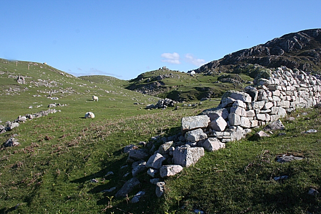
Ceannabeinne One house survives here, but there are plenty of ruinous walls to indicate where further houses once stood.
952:
729:
701:
671:
606:
487:
470:
310:
369:
1125:
1120:
42:
1201:
If the file has been modified from its original state, some details may not fully reflect the modified file.
412:– If you remix, transform, or build upon the material, you must distribute your contributions under the
330:
on the
Geograph website for the photographer's contact details. The copyright on this image is owned by
1136:
366:
828:"}},"text\/plain":{"en":{"P7787":"180 degree"}}}}": -->
764:"}},"text\/plain":{"en":{"P7787":"180 degree"}}}}": -->
91:
183:
708:
693:
167:
549:
294:
244:
335:
78:
1157:
135:
278:
228:
146:
156:
315:
327:
1093:
Click on a date/time to view the file as it appeared at that time.
280:
230:
255:
205:
66:
265:
58° 33′ 02″ N, 4° 40′ 59″ W
215:
58° 33′ 14″ N, 4° 41′ 02″ W
454:
Add a one-line explanation of what this file represents
1185:
1175:
110:
90:
Commons is a freely licensed media file repository.
623:
Creative
Commons Attribution-ShareAlike 2.0 Generic
56:(640 × 427 pixels, file size: 257 KB, MIME type:
423:https://creativecommons.org/licenses/by-sa/2.0
71:
429:Creative Commons Attribution-Share Alike 2.0
347:
8:
825:
761:
389:– to copy, distribute and transmit the work
116:Ceannabeinne - geograph.org.uk - 822157.jpg
52:Ceannabeinne_-_geograph.org.uk_-_822157.jpg
1203:
1095:
450:
1168:The following other wikis use this file:
941:ae887cba6e6a4113870b86f5df5d0f4392e7da20
709:https://www.geograph.org.uk/photo/822157
1205:
1155:
1068:
1052:
1031:
1015:
994:
978:
939:
923:
905:
889:
849:
833:
785:
769:
743:
727:
656:
640:
620:
604:
584:
568:
550:https://www.geograph.org.uk/profile/139
501:
485:
468:
465:
446:
439:
258:
208:
287:View this and other nearby images on:
237:View this and other nearby images on:
7:
334:and is licensed for reuse under the
1153:The following page uses this file:
1084:
370:Attribution-Share Alike 2.0 Generic
358:
353:
338:Attribution-ShareAlike 2.0 license.
1196:
459:
453:
344:
321:
120:
103:
49:
458:
772:coordinates of the point of view
444:
400:Under the following conditions:
365:This file is licensed under the
357:
352:
346:
314:
293:
279:
271:
243:
229:
221:
70:
31:
21:
441:
121:
46:No higher resolution available.
14:
659:file available on the internet
440:
322:This image was taken from the
26:
1:
836:coordinates of depicted place
36:
679:Geograph Britain and Ireland
515:object of statement has role
466:Items portrayed in this file
270:
220:
1227:
1182:Usage on www.wikidata.org
1172:Usage on es.wikipedia.org
851:58°33'1.91"N, 4°40'59.16"W
787:58°33'13.82"N, 4°41'2.04"W
414:same or compatible license
1085:
196:Anne Burgess /
177:Anne Burgess /
16:
687:geograph.org.uk image ID
443:
380:
77:This is a file from the
1142:
1121:15:13, 20 February 2011
168:required by the license
152:
141:
134:
131:
113:
81:. Information from its
328:this photograph's page
299:58.550530; -4.683100
249:58.553840; -4.683900
84:description page there
953:determination method
395:– to adapt the work
530:author name string
1214:
1213:
1164:Global file usage
1146:
827:
763:
607:copyright license
452:
343:
342:
326:collection. See
304:
303:
254:
253:
203:
202:
171:
99:
98:
79:Wikimedia Commons
32:Global file usage
1218:
1204:
1133:
1073:
1036:
999:
962:
957:
873:
872:
867:
809:
808:
803:
711:
706:
702:described at URL
696:
691:
681:
676:
571:copyright status
552:
547:
537:
534:
524:
519:
436:
433:
430:
427:
424:
416:as the original.
378:
367:Creative Commons
361:
360:
356:
355:
350:
349:
336:Creative Commons
324:Geograph project
318:
311:
300:
297:
283:
282:
276:
275:
274:
268:
267:
256:
250:
247:
233:
232:
226:
225:
224:
218:
217:
206:
165:
137:
125:
117:
111:
95:
74:
73:
67:
61:
59:
1226:
1225:
1221:
1220:
1219:
1217:
1216:
1215:
1192:
1162:
1147:
1139:
1131:
1087:
1086:
1083:
1082:
1081:
1080:
1079:
1078:
1077:
1076:
1074:
1071:
1061:
1060:
1059:
1057:
1046:
1045:
1044:
1043:
1042:
1041:
1040:
1039:
1037:
1034:
1024:
1023:
1022:
1020:
1009:
1008:
1007:
1006:
1005:
1004:
1003:
1002:
1000:
997:
987:
986:
985:
983:
972:
971:
970:
969:
968:
967:
966:
965:
964:
963:
958:
955:
946:
945:
944:
942:
932:
931:
930:
928:
917:
916:
915:
914:
913:
912:
911:
910:
908:
898:
897:
896:
894:
883:
882:
881:
880:
879:
878:
877:
876:
875:
874:
870:
868:
865:
856:
855:
854:
852:
842:
841:
840:
838:
819:
818:
817:
816:
815:
814:
813:
812:
811:
810:
806:
804:
801:
792:
791:
790:
788:
778:
777:
776:
774:
755:
754:
753:
752:
751:
750:
749:
748:
746:
736:
735:
734:
732:
721:
720:
719:
718:
717:
716:
715:
714:
713:
712:
707:
704:
698:
697:
692:
689:
683:
682:
677:
674:
665:
664:
663:
661:
649:
648:
647:
645:
634:
633:
632:
631:
630:
629:
628:
627:
625:
613:
612:
611:
609:
598:
597:
596:
595:
594:
593:
592:
591:
589:
577:
576:
575:
573:
562:
561:
560:
559:
558:
557:
556:
555:
554:
553:
548:
545:
539:
538:
535:
532:
526:
525:
520:
517:
508:
507:
506:
504:
494:
493:
492:
490:
479:
478:
477:
476:
475:
473:
457:
456:
455:
438:
437:
434:
431:
428:
425:
422:
421:
379:
376:
373:
362:
339:
309:
298:
272:
263:
262:
259:Object location
248:
222:
213:
212:
209:Camera location
204:
193:
186:
174:
147:geograph.org.uk
127:
115:
108:
101:
100:
89:
88:
87:is shown below.
63:
57:
55:
48:
47:
12:
11:
5:
1224:
1222:
1212:
1211:
1208:
1195:
1191:
1190:
1189:
1188:
1180:
1179:
1178:
1166:
1165:
1161:
1160:
1151:
1150:
1145:
1144:
1141:
1137:
1134:
1128:
1123:
1118:
1114:
1113:
1110:
1107:
1104:
1101:
1098:
1091:
1090:
1075:
1069:
1067:
1066:
1065:
1064:
1063:
1062:
1058:
1053:
1051:
1050:
1049:
1048:
1047:
1038:
1032:
1030:
1029:
1028:
1027:
1026:
1025:
1021:
1016:
1014:
1013:
1012:
1011:
1010:
1001:
995:
993:
992:
991:
990:
989:
988:
984:
979:
977:
976:
975:
974:
973:
951:
950:
949:
948:
947:
943:
940:
938:
937:
936:
935:
934:
933:
929:
924:
922:
921:
920:
919:
918:
909:
906:
904:
903:
902:
901:
900:
899:
895:
890:
888:
887:
886:
885:
884:
861:
860:
859:
858:
857:
853:
850:
848:
847:
846:
845:
844:
843:
839:
834:
832:
831:
830:
829:
823:
797:
796:
795:
794:
793:
789:
786:
784:
783:
782:
781:
780:
779:
775:
770:
768:
767:
766:
765:
759:
747:
744:
742:
741:
740:
739:
738:
737:
733:
728:
726:
725:
724:
723:
722:
700:
699:
685:
684:
670:
669:
668:
667:
666:
662:
657:
655:
654:
653:
652:
651:
650:
646:
643:source of file
641:
639:
638:
637:
636:
635:
626:
621:
619:
618:
617:
616:
615:
614:
610:
605:
603:
602:
601:
600:
599:
590:
585:
583:
582:
581:
580:
579:
578:
574:
569:
567:
566:
565:
564:
563:
541:
540:
528:
527:
513:
512:
511:
510:
509:
505:
502:
500:
499:
498:
497:
496:
495:
491:
486:
484:
483:
482:
481:
480:
474:
469:
467:
464:
463:
462:
461:
460:
449:
448:
445:
442:
420:
419:
418:
417:
407:
398:
397:
396:
390:
383:You are free:
374:
364:
363:
345:
341:
340:
319:
308:
305:
302:
301:
291:
285:
260:
252:
251:
241:
235:
210:
201:
200:
194:
191:
188:
187:
182:
175:
172:
160:
159:
154:
150:
149:
143:
139:
138:
133:
129:
128:
118:
109:
107:
104:
102:
97:
96:
75:
65:
64:
45:
41:
40:
39:
34:
29:
24:
19:
13:
10:
9:
6:
4:
3:
2:
1223:
1209:
1206:
1202:
1199:
1193:
1187:
1184:
1183:
1181:
1177:
1174:
1173:
1171:
1170:
1169:
1163:
1159:
1156:
1154:
1148:
1140:
1135:
1129:
1127:
1124:
1122:
1119:
1116:
1115:
1111:
1108:
1105:
1102:
1099:
1097:
1096:
1094:
1088:
1056:
1019:
982:
961:
954:
927:
893:
864:
837:
800:
773:
731:
710:
703:
695:
688:
680:
673:
660:
644:
624:
608:
588:
572:
551:
544:
531:
523:
516:
489:
472:
426:CC BY-SA 2.0
415:
411:
408:
405:
402:
401:
399:
394:
391:
388:
385:
384:
382:
381:
375:Attribution:
371:
368:
351:
337:
333:
329:
325:
320:
317:
313:
312:
306:
296:
292:
290:
289:OpenStreetMap
286:
284:
266:
261:
257:
246:
242:
240:
239:OpenStreetMap
236:
234:
216:
211:
207:
199:
195:
190:
189:
185:
181: /
180:
176:
169:
164:
162:
161:
158:
155:
151:
148:
144:
140:
130:
124:
119:
112:
105:
93:
86:
85:
80:
76:
69:
68:
62:
53:
44:
38:
35:
33:
30:
28:
25:
23:
20:
18:
15:
1200:
1197:
1167:
1158:Ceannabeinne
1152:
1092:
1089:File history
536:Anne Burgess
522:photographer
409:
403:
392:
386:
377:Anne Burgess
332:Anne Burgess
331:
269:
219:
198:Ceannabeinne
197:
184:CC BY-SA 2.0
179:Ceannabeinne
178:
157:Anne Burgess
122:
92:You can help
82:
50:
22:File history
1138:GeographBot
745:24 May 2008
587:copyrighted
410:share alike
404:attribution
163:Attribution
136:24 May 2008
114:Description
1207:_error
1149:File usage
1130:640 × 427
1106:Dimensions
907:image/jpeg
892:media type
503:some value
58:image/jpeg
27:File usage
1103:Thumbnail
1100:Date/Time
981:data size
730:inception
307:Licensing
192:InfoField
173:InfoField
123:English:
1194:Metadata
1186:Q2755585
1132:(257 KB)
996:262,852
926:checksum
672:operator
447:Captions
393:to remix
387:to share
372:license.
37:Metadata
1176:Durness
1117:current
1112:Comment
863:heading
822:heading
799:heading
758:heading
488:creator
471:depicts
451:English
106:Summary
54:
1018:height
871:degree
826:degree
807:degree
762:degree
694:822157
277:
227:
153:Author
142:Source
1072:pixel
1055:width
1035:pixel
960:SHA-1
145:From
1109:User
1070:640
1033:427
998:byte
869:180
805:180
435:true
432:true
132:Date
17:File
543:URL
956::
866::
802::
705::
690::
675::
546::
533::
518::
1210:0
170:)
166:(
94:.
60:)
Text is available under the Creative Commons Attribution-ShareAlike License. Additional terms may apply.
_heading:180.00&language=en)
_heading:180.00&language=en)
