305:
238:
252:
273:
311:
43:
316:
87:
1044:
1085:
229:
363:– You must give appropriate credit, provide a link to the license, and indicate if changes were made. You may do so in any reasonable manner, but not in any way that suggests the licensor endorses you or your use.
1061:== {{int:filedesc}} == {{Information |description={{en|1=Church, Llangurig. This large church is set back from a busy road.}} |date=2005-08-20 |source=From |author=[http://www.geograph.org.uk/profil
53:
47:
98:
66:
1075:
877:
634:
598:
562:
443:
245:
755:
669:
280:
1116:
This file contains additional information, probably added from the digital camera or scanner used to create or digitize it.
370:
497:
972:
935:
898:
843:
809:
775:
739:
647:
618:
546:
518:
505:
490:
870:
705:
677:
662:
582:
463:
427:
1043:
1038:
57:
42:
267:
1080:
326:
1119:
If the file has been modified from its original state, some details may not fully reflect the modified file.
1071:
The following pages on the
English Knowledge (XXG) use this file (pages on other projects are not listed):
369:– If you remix, transform, or build upon the material, you must distribute your contributions under the
287:
on the
Geograph website for the photographer's contact details. The copyright on this image is owned by
1054:
323:
106:
198:
182:
684:
654:
525:
1086:
Knowledge (XXG):WikiProject
Historic sites/Images of listed buildings in Wales without ID
251:
292:
93:
150:
235:
171:
161:
272:
284:
1011:
Click on a date/time to view the file as it appeared at that time.
141:
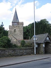
Church, Llangurig. This large church is set back from a busy road.
237:
220:
81:
768:
230:
52° 24′ 21″ N, 3° 36′ 22″ W
411:
Add a one-line explanation of what this file represents
1103:
125:
105:
Commons is a freely licensed media file repository.
599:
Creative
Commons Attribution-ShareAlike 2.0 Generic
71:(480 × 640 pixels, file size: 81 KB, MIME type:
131:Church, Llangurig - geograph.org.uk - 41908.jpg
380:https://creativecommons.org/licenses/by-sa/2.0
86:
386:Creative Commons Attribution-Share Alike 2.0
304:
8:
346:– to copy, distribute and transmit the work
1121:
1013:
407:
1096:The following other wikis use this file:
859:363d83b452cd3f90ed4807356e1222e1ccaea526
1123:
1073:
986:
970:
949:
933:
912:
896:
857:
841:
823:
807:
789:
773:
753:
737:
719:
703:
685:https://www.geograph.org.uk/photo/41908
632:
616:
596:
580:
560:
544:
526:https://www.geograph.org.uk/profile/506
477:
461:
441:
425:
422:
403:
396:
223:
244:View this and other nearby images on:
7:
291:and is licensed for reuse under the
1076:Grade II* listed buildings in Powys
1002:
327:Attribution-Share Alike 2.0 Generic
315:
310:
295:Attribution-ShareAlike 2.0 license.
1114:
416:
410:
301:
278:
135:
118:
64:
415:
401:
357:Under the following conditions:
322:This file is licensed under the
314:
309:
303:
271:
250:
236:
85:
31:
21:
398:
136:
14:
635:file available on the internet
397:
279:This image was taken from the
26:
1:
776:coordinates of depicted place
36:
670:Geograph Britain and Ireland
491:object of statement has role
423:Items portrayed in this file
211:Angella Streluk /
192:Angella Streluk /
1145:
1100:Usage on it.wikipedia.org
371:same or compatible license
1081:Jacob Youde William Lloyd
1003:
791:52°24'20.5"N, 3°36'21.6"W
16:
648:geograph.org.uk image ID
400:
337:
92:This is a file from the
1060:
183:required by the license
167:
156:
149:
146:
128:
96:. Information from its
1039:13:38, 30 January 2010
285:this photograph's page
256:52.405700; -3.606000
99:description page there
46:Size of this preview:
871:determination method
740:location of creation
352:– to adapt the work
52:Other resolutions:
506:author name string
444:Church of St Curig
1132:
1131:
1092:Global file usage
1064:
583:copyright license
409:
300:
299:
283:collection. See
261:
260:
218:
217:
213:Church, Llangurig
194:Church, Llangurig
186:
114:
113:
94:Wikimedia Commons
32:Global file usage
1136:
1122:
1051:
991:
954:
917:
880:
875:
687:
682:
678:described at URL
672:
667:
657:
652:
547:copyright status
528:
523:
513:
510:
500:
495:
393:
390:
387:
384:
381:
373:as the original.
335:
324:Creative Commons
318:
317:
313:
312:
307:
306:
293:Creative Commons
281:Geograph project
275:
268:
257:
254:
240:
239:
233:
232:
221:
180:
152:
140:
132:
126:
110:
89:
88:
82:
76:
74:
61:
58:480 × 640 pixels
54:180 × 240 pixels
48:450 × 600 pixels
1144:
1143:
1139:
1138:
1137:
1135:
1134:
1133:
1110:
1090:
1072:
1065:
1057:
1049:
1005:
1004:
1001:
1000:
999:
998:
997:
996:
995:
994:
992:
989:
979:
978:
977:
975:
964:
963:
962:
961:
960:
959:
958:
957:
955:
952:
942:
941:
940:
938:
927:
926:
925:
924:
923:
922:
921:
920:
918:
915:
905:
904:
903:
901:
890:
889:
888:
887:
886:
885:
884:
883:
882:
881:
876:
873:
864:
863:
862:
860:
850:
849:
848:
846:
835:
834:
833:
832:
831:
830:
829:
828:
826:
816:
815:
814:
812:
801:
800:
799:
798:
797:
796:
795:
794:
792:
782:
781:
780:
778:
767:
766:
765:
764:
763:
762:
761:
760:
758:
746:
745:
744:
742:
731:
730:
729:
728:
727:
726:
725:
724:
722:
712:
711:
710:
708:
697:
696:
695:
694:
693:
692:
691:
690:
689:
688:
683:
680:
674:
673:
668:
665:
659:
658:
653:
650:
641:
640:
639:
637:
625:
624:
623:
621:
610:
609:
608:
607:
606:
605:
604:
603:
601:
589:
588:
587:
585:
574:
573:
572:
571:
570:
569:
568:
567:
565:
553:
552:
551:
549:
538:
537:
536:
535:
534:
533:
532:
531:
530:
529:
524:
521:
515:
514:
512:Angella Streluk
511:
508:
502:
501:
496:
493:
484:
483:
482:
480:
470:
469:
468:
466:
455:
454:
453:
452:
451:
450:
449:
448:
446:
434:
433:
432:
430:
414:
413:
412:
395:
394:
391:
388:
385:
382:
379:
378:
336:
334:Angella Streluk
333:
330:
319:
296:
289:Angella Streluk
266:
255:
228:
227:
224:Object location
219:
208:
201:
189:
172:Angella Streluk
162:geograph.org.uk
142:
130:
123:
116:
115:
104:
103:
102:is shown below.
78:
72:
70:
63:
62:
51:
12:
11:
5:
1142:
1140:
1130:
1129:
1126:
1113:
1109:
1108:
1107:
1106:
1094:
1093:
1089:
1088:
1083:
1078:
1070:
1069:
1068:
1063:
1062:
1059:
1055:
1052:
1046:
1041:
1036:
1032:
1031:
1028:
1025:
1022:
1019:
1016:
1009:
1008:
993:
987:
985:
984:
983:
982:
981:
980:
976:
971:
969:
968:
967:
966:
965:
956:
950:
948:
947:
946:
945:
944:
943:
939:
934:
932:
931:
930:
929:
928:
919:
913:
911:
910:
909:
908:
907:
906:
902:
897:
895:
894:
893:
892:
891:
869:
868:
867:
866:
865:
861:
858:
856:
855:
854:
853:
852:
851:
847:
842:
840:
839:
838:
837:
836:
827:
824:
822:
821:
820:
819:
818:
817:
813:
808:
806:
805:
804:
803:
802:
793:
790:
788:
787:
786:
785:
784:
783:
779:
774:
772:
771:
770:
769:
759:
754:
752:
751:
750:
749:
748:
747:
743:
738:
736:
735:
734:
733:
732:
723:
721:20 August 2005
720:
718:
717:
716:
715:
714:
713:
709:
704:
702:
701:
700:
699:
698:
676:
675:
661:
660:
646:
645:
644:
643:
642:
638:
633:
631:
630:
629:
628:
627:
626:
622:
619:source of file
617:
615:
614:
613:
612:
611:
602:
597:
595:
594:
593:
592:
591:
590:
586:
581:
579:
578:
577:
576:
575:
566:
561:
559:
558:
557:
556:
555:
554:
550:
545:
543:
542:
541:
540:
539:
517:
516:
504:
503:
489:
488:
487:
486:
485:
481:
478:
476:
475:
474:
473:
472:
471:
467:
462:
460:
459:
458:
457:
456:
447:
442:
440:
439:
438:
437:
436:
435:
431:
426:
424:
421:
420:
419:
418:
417:
406:
405:
402:
399:
377:
376:
375:
374:
364:
355:
354:
353:
347:
340:You are free:
331:
321:
320:
302:
298:
297:
276:
265:
262:
259:
258:
248:
242:
225:
216:
215:
209:
206:
203:
202:
197:
190:
187:
175:
174:
169:
165:
164:
158:
154:
153:
151:20 August 2005
148:
144:
143:
133:
124:
122:
119:
117:
112:
111:
90:
80:
79:
45:
41:
40:
39:
34:
29:
24:
19:
13:
10:
9:
6:
4:
3:
2:
1141:
1127:
1124:
1120:
1117:
1111:
1105:
1102:
1101:
1099:
1098:
1097:
1091:
1087:
1084:
1082:
1079:
1077:
1074:
1066:
1058:
1053:
1047:
1045:
1042:
1040:
1037:
1034:
1033:
1029:
1026:
1023:
1020:
1017:
1015:
1014:
1012:
1006:
974:
937:
900:
879:
872:
845:
811:
777:
757:
741:
707:
686:
679:
671:
664:
656:
649:
636:
620:
600:
584:
564:
548:
527:
520:
507:
499:
492:
465:
445:
429:
383:CC BY-SA 2.0
372:
368:
365:
362:
359:
358:
356:
351:
348:
345:
342:
341:
339:
338:
332:Attribution:
328:
325:
308:
294:
290:
286:
282:
277:
274:
270:
269:
263:
253:
249:
247:
246:OpenStreetMap
243:
241:
231:
226:
222:
214:
210:
205:
204:
200:
196: /
195:
191:
184:
179:
177:
176:
173:
170:
166:
163:
159:
155:
145:
139:
134:
127:
120:
108:
101:
100:
95:
91:
84:
83:
77:
68:
67:Original file
59:
55:
49:
44:
38:
35:
33:
30:
28:
25:
23:
20:
18:
15:
1118:
1115:
1095:
1010:
1007:File history
498:photographer
366:
360:
349:
343:
288:
212:
199:CC BY-SA 2.0
193:
137:
107:You can help
97:
65:
22:File history
1056:GeographBot
563:copyrighted
367:share alike
361:attribution
178:Attribution
129:Description
1125:_error
1067:File usage
1048:480 × 640
1024:Dimensions
825:image/jpeg
810:media type
479:some value
73:image/jpeg
27:File usage
1104:Llangurig
1021:Thumbnail
1018:Date/Time
899:data size
756:Llangurig
706:inception
264:Licensing
207:InfoField
188:InfoField
138:English:
1112:Metadata
844:checksum
663:operator
404:Captions
350:to remix
344:to share
329:license.
37:Metadata
1050:(81 KB)
1035:current
1030:Comment
914:83,350
464:creator
428:depicts
408:English
121:Summary
69:
936:height
234:
168:Author
157:Source
990:pixel
973:width
953:pixel
878:SHA-1
655:41908
160:From
1027:User
988:480
951:640
916:byte
392:true
389:true
147:Date
17:File
519:URL
874::
681::
666::
651::
522::
509::
494::
56:|
50:.
1128:0
185:)
181:(
109:.
75:)
60:.
Text is available under the Creative Commons Attribution-ShareAlike License. Additional terms may apply.

_&language=en)
