348:
281:
231:
273:
223:
295:
245:
316:
354:
359:
72:
824:"}},"text\/plain":{"en":{"":"heading"}}},"{\"value\":{\"amount\":\"+45\",\"unit\":\"http:\\\/\\\/www.wikidata.org\\\/entity\\\/Q28390\"},\"type\":\"quantity\"}":{"text\/html":{"en":{"P7787":"45
760:"}},"text\/plain":{"en":{"":"heading"}}},"{\"value\":{\"amount\":\"+45\",\"unit\":\"http:\\\/\\\/www.wikidata.org\\\/entity\\\/Q28390\"},\"type\":\"quantity\"}":{"text\/html":{"en":{"P7787":"45
1126:
820:
214:
1143:== {{int:filedesc}} == {{Information |description={{en|1=Church of All Saints, Thrumpton The churchyard offering its own flower festival - covered in daffodils and primroses.}} |date=2008-03-25 |source=From [http://www.geograph.org.uk/photo/739617 geograp
43:
406:– You must give appropriate credit, provide a link to the license, and indicate if changes were made. You may do so in any reasonable manner, but not in any way that suggests the licensor endorses you or your use.
83:
51:
1167:
821:
757:
1162:
1125:
1120:
42:
959:
658:
622:
586:
288:
238:
693:
323:
1233:
This file contains additional information, probably added from the digital camera or scanner used to create or digitize it.
413:
549:
1157:
1054:
1017:
980:
925:
891:
862:
835:
798:
771:
671:
642:
570:
542:
527:
514:
952:
729:
701:
686:
606:
487:
470:
126:
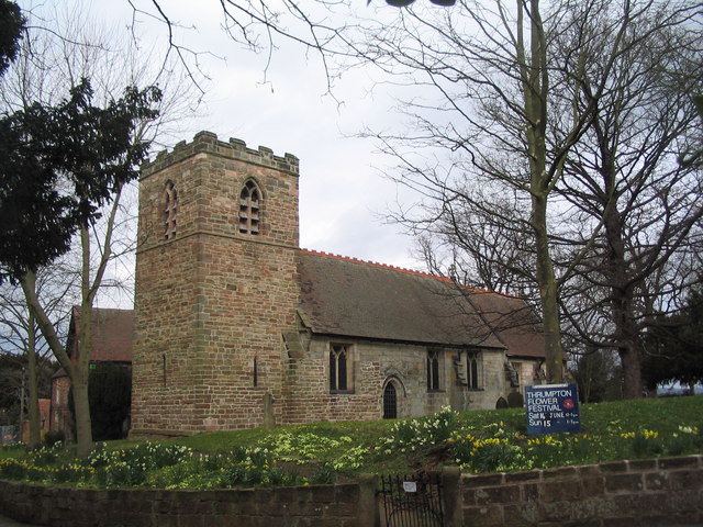
Church of All Saints, Thrumpton The churchyard offering its own flower festival - covered in daffodils and primroses.
310:
369:
1236:
If the file has been modified from its original state, some details may not fully reflect the modified file.
412:– If you remix, transform, or build upon the material, you must distribute your contributions under the
330:
on the
Geograph website for the photographer's contact details. The copyright on this image is owned by
1136:
366:
828:"}},"text\/plain":{"en":{"P7787":"45 degree"}}}}": -->
764:"}},"text\/plain":{"en":{"P7787":"45 degree"}}}}": -->
91:
183:
1200:
1190:
708:
678:
534:
167:
294:
244:
335:
78:
135:
278:
228:
1172:
156:
146:
315:
327:
1093:
Click on a date/time to view the file as it appeared at that time.
280:
230:
255:
205:
116:
Church of All Saints, Thrumpton - geograph.org.uk - 739617.jpg
66:
52:
Church_of_All_Saints,_Thrumpton_-_geograph.org.uk_-_739617.jpg
1168:
List of church restorations and alterations by G. E. Street
265:
52° 52′ 33″ N, 1° 14′ 39″ W
215:
52° 52′ 31″ N, 1° 14′ 41″ W
454:
Add a one-line explanation of what this file represents
1220:
1210:
110:
90:
Commons is a freely licensed media file repository.
623:
Creative
Commons Attribution-ShareAlike 2.0 Generic
56:(640 × 480 pixels, file size: 120 KB, MIME type:
423:https://creativecommons.org/licenses/by-sa/2.0
71:
1191:Grade II* listed buildings in Nottinghamshire
1163:Grade II* listed buildings in Nottinghamshire
429:Creative Commons Attribution-Share Alike 2.0
347:
8:
825:
761:
389:– to copy, distribute and transmit the work
1238:
1095:
450:
1183:The following other wikis use this file:
941:797ae949aa35d8e5a477a4ae3fa21b29c4e95c57
709:https://www.geograph.org.uk/photo/739617
535:https://www.geograph.org.uk/profile/3240
1240:
1155:
1068:
1052:
1031:
1015:
994:
978:
939:
923:
905:
889:
849:
833:
785:
769:
743:
727:
656:
640:
620:
604:
584:
568:
501:
485:
468:
465:
446:
439:
258:
208:
287:View this and other nearby images on:
237:View this and other nearby images on:
1153:The following 4 pages use this file:
7:
334:and is licensed for reuse under the
1084:
370:Attribution-Share Alike 2.0 Generic
358:
353:
338:Attribution-ShareAlike 2.0 license.
1231:
459:
453:
344:
321:
120:
103:
49:
458:
772:coordinates of the point of view
444:
400:Under the following conditions:
365:This file is licensed under the
357:
352:
346:
314:
293:
279:
271:
243:
229:
221:
70:
31:
21:
441:
198:Church of All Saints, Thrumpton
179:Church of All Saints, Thrumpton
121:
46:No higher resolution available.
14:
659:file available on the internet
440:
322:This image was taken from the
26:
1:
836:coordinates of depicted place
36:
1158:All Saints Church, Thrumpton
694:Geograph Britain and Ireland
543:object of statement has role
466:Items portrayed in this file
1187:Usage on dag.wikipedia.org
851:52°52'32.63"N, 1°14'39.12"W
787:52°52'30.68"N, 1°14'41.28"W
270:
220:
1262:
1217:Usage on www.wikidata.org
1207:Usage on it.wikipedia.org
1197:Usage on fa.wikipedia.org
414:same or compatible license
1085:
16:
672:geograph.org.uk image ID
443:
380:
77:This is a file from the
1142:
1121:07:33, 19 February 2011
196:Tim Heaton /
177:Tim Heaton /
168:required by the license
152:
141:
134:
131:
113:
81:. Information from its
328:this photograph's page
299:52.875730; -1.244200
249:52.875190; -1.244800
84:description page there
953:determination method
395:– to adapt the work
515:author name string
1249:
1248:
1179:Global file usage
1146:
827:
763:
607:copyright license
452:
343:
342:
326:collection. See
304:
303:
254:
253:
203:
202:
171:
99:
98:
79:Wikimedia Commons
32:Global file usage
1253:
1239:
1133:
1073:
1036:
999:
962:
957:
873:
872:
867:
809:
808:
803:
711:
706:
702:described at URL
696:
691:
681:
676:
571:copyright status
552:
547:
537:
532:
522:
519:
436:
433:
430:
427:
424:
416:as the original.
378:
367:Creative Commons
361:
360:
356:
355:
350:
349:
336:Creative Commons
324:Geograph project
318:
311:
300:
297:
283:
282:
276:
275:
274:
268:
267:
256:
250:
247:
233:
232:
226:
225:
224:
218:
217:
206:
165:
137:
125:
117:
111:
95:
74:
73:
67:
61:
59:
1261:
1260:
1256:
1255:
1254:
1252:
1251:
1250:
1227:
1177:
1147:
1139:
1131:
1087:
1086:
1083:
1082:
1081:
1080:
1079:
1078:
1077:
1076:
1074:
1071:
1061:
1060:
1059:
1057:
1046:
1045:
1044:
1043:
1042:
1041:
1040:
1039:
1037:
1034:
1024:
1023:
1022:
1020:
1009:
1008:
1007:
1006:
1005:
1004:
1003:
1002:
1000:
997:
987:
986:
985:
983:
972:
971:
970:
969:
968:
967:
966:
965:
964:
963:
958:
955:
946:
945:
944:
942:
932:
931:
930:
928:
917:
916:
915:
914:
913:
912:
911:
910:
908:
898:
897:
896:
894:
883:
882:
881:
880:
879:
878:
877:
876:
875:
874:
870:
868:
865:
856:
855:
854:
852:
842:
841:
840:
838:
819:
818:
817:
816:
815:
814:
813:
812:
811:
810:
806:
804:
801:
792:
791:
790:
788:
778:
777:
776:
774:
755:
754:
753:
752:
751:
750:
749:
748:
746:
736:
735:
734:
732:
721:
720:
719:
718:
717:
716:
715:
714:
713:
712:
707:
704:
698:
697:
692:
689:
683:
682:
677:
674:
665:
664:
663:
661:
649:
648:
647:
645:
634:
633:
632:
631:
630:
629:
628:
627:
625:
613:
612:
611:
609:
598:
597:
596:
595:
594:
593:
592:
591:
589:
577:
576:
575:
573:
562:
561:
560:
559:
558:
557:
556:
555:
554:
553:
548:
545:
539:
538:
533:
530:
524:
523:
520:
517:
508:
507:
506:
504:
494:
493:
492:
490:
479:
478:
477:
476:
475:
473:
457:
456:
455:
438:
437:
434:
431:
428:
425:
422:
421:
379:
376:
373:
362:
339:
309:
298:
272:
263:
262:
259:Object location
248:
222:
213:
212:
209:Camera location
204:
193:
186:
174:
147:geograph.org.uk
127:
115:
108:
101:
100:
89:
88:
87:is shown below.
63:
57:
55:
48:
47:
12:
11:
5:
1259:
1257:
1247:
1246:
1243:
1230:
1226:
1225:
1224:
1223:
1215:
1214:
1213:
1205:
1204:
1203:
1195:
1194:
1193:
1181:
1180:
1176:
1175:
1170:
1165:
1160:
1151:
1150:
1145:
1144:
1141:
1137:
1134:
1128:
1123:
1118:
1114:
1113:
1110:
1107:
1104:
1101:
1098:
1091:
1090:
1075:
1069:
1067:
1066:
1065:
1064:
1063:
1062:
1058:
1053:
1051:
1050:
1049:
1048:
1047:
1038:
1032:
1030:
1029:
1028:
1027:
1026:
1025:
1021:
1016:
1014:
1013:
1012:
1011:
1010:
1001:
995:
993:
992:
991:
990:
989:
988:
984:
979:
977:
976:
975:
974:
973:
951:
950:
949:
948:
947:
943:
940:
938:
937:
936:
935:
934:
933:
929:
924:
922:
921:
920:
919:
918:
909:
906:
904:
903:
902:
901:
900:
899:
895:
890:
888:
887:
886:
885:
884:
861:
860:
859:
858:
857:
853:
850:
848:
847:
846:
845:
844:
843:
839:
834:
832:
831:
830:
829:
823:
797:
796:
795:
794:
793:
789:
786:
784:
783:
782:
781:
780:
779:
775:
770:
768:
767:
766:
765:
759:
747:
744:
742:
741:
740:
739:
738:
737:
733:
728:
726:
725:
724:
723:
722:
700:
699:
685:
684:
670:
669:
668:
667:
666:
662:
657:
655:
654:
653:
652:
651:
650:
646:
643:source of file
641:
639:
638:
637:
636:
635:
626:
621:
619:
618:
617:
616:
615:
614:
610:
605:
603:
602:
601:
600:
599:
590:
585:
583:
582:
581:
580:
579:
578:
574:
569:
567:
566:
565:
564:
563:
541:
540:
526:
525:
513:
512:
511:
510:
509:
505:
502:
500:
499:
498:
497:
496:
495:
491:
486:
484:
483:
482:
481:
480:
474:
469:
467:
464:
463:
462:
461:
460:
449:
448:
445:
442:
420:
419:
418:
417:
407:
398:
397:
396:
390:
383:You are free:
374:
364:
363:
345:
341:
340:
319:
308:
305:
302:
301:
291:
285:
260:
252:
251:
241:
235:
210:
201:
200:
194:
191:
188:
187:
182:
175:
172:
160:
159:
154:
150:
149:
143:
139:
138:
133:
129:
128:
118:
109:
107:
104:
102:
97:
96:
75:
65:
64:
45:
41:
40:
39:
34:
29:
24:
19:
13:
10:
9:
6:
4:
3:
2:
1258:
1244:
1241:
1237:
1234:
1228:
1222:
1219:
1218:
1216:
1212:
1209:
1208:
1206:
1202:
1199:
1198:
1196:
1192:
1189:
1188:
1186:
1185:
1184:
1178:
1174:
1171:
1169:
1166:
1164:
1161:
1159:
1156:
1154:
1148:
1140:
1135:
1129:
1127:
1124:
1122:
1119:
1116:
1115:
1111:
1108:
1105:
1102:
1099:
1097:
1096:
1094:
1088:
1056:
1019:
982:
961:
954:
927:
893:
864:
837:
800:
773:
745:25 March 2008
731:
710:
703:
695:
688:
680:
673:
660:
644:
624:
608:
588:
572:
551:
544:
536:
529:
516:
489:
472:
426:CC BY-SA 2.0
415:
411:
408:
405:
402:
401:
399:
394:
391:
388:
385:
384:
382:
381:
375:Attribution:
371:
368:
351:
337:
333:
329:
325:
320:
317:
313:
312:
306:
296:
292:
290:
289:OpenStreetMap
286:
284:
266:
261:
257:
246:
242:
240:
239:OpenStreetMap
236:
234:
216:
211:
207:
199:
195:
190:
189:
185:
181: /
180:
176:
169:
164:
162:
161:
158:
155:
151:
148:
144:
140:
136:25 March 2008
130:
124:
119:
112:
105:
93:
86:
85:
80:
76:
69:
68:
62:
53:
44:
38:
35:
33:
30:
28:
25:
23:
20:
18:
15:
1235:
1232:
1182:
1152:
1092:
1089:File history
550:photographer
409:
403:
392:
386:
331:
269:
219:
197:
184:CC BY-SA 2.0
178:
122:
92:You can help
82:
50:
22:File history
1138:GeographBot
587:copyrighted
410:share alike
404:attribution
163:Attribution
114:Description
1242:_error
1149:File usage
1130:640 × 480
1106:Dimensions
907:image/jpeg
892:media type
521:Tim Heaton
503:some value
377:Tim Heaton
332:Tim Heaton
157:Tim Heaton
58:image/jpeg
27:File usage
1221:Q15978869
1211:Thrumpton
1173:Thrumpton
1103:Thumbnail
1100:Date/Time
981:data size
730:inception
307:Licensing
192:InfoField
173:InfoField
123:English:
1229:Metadata
1201:ترامپتون
1132:(120 KB)
996:123,073
926:checksum
687:operator
447:Captions
393:to remix
387:to share
372:license.
37:Metadata
1117:current
1112:Comment
863:heading
822:heading
799:heading
758:heading
488:creator
471:depicts
451:English
106:Summary
54:
1018:height
871:degree
826:degree
807:degree
762:degree
679:739617
277:
227:
153:Author
142:Source
1072:pixel
1055:width
1035:pixel
960:SHA-1
145:From
1109:User
1070:640
1033:480
998:byte
435:true
432:true
132:Date
17:File
869:45
805:45
528:URL
956::
866::
802::
705::
690::
675::
546::
531::
518::
1245:0
170:)
166:(
94:.
60:)
Text is available under the Creative Commons Attribution-ShareAlike License. Additional terms may apply.
_heading:45.00&language=en)
_heading:45.00&language=en)
