295:
228:
220:
43:
242:
263:
301:
306:
91:
673:"}},"text\/plain":{"en":{"":"heading"}}},"{\"value\":{\"amount\":\"+202\",\"unit\":\"http:\\\/\\\/www.wikidata.org\\\/entity\\\/Q28390\"},\"type\":\"quantity\"}":{"text\/html":{"en":{"P7787":"202
669:
149:
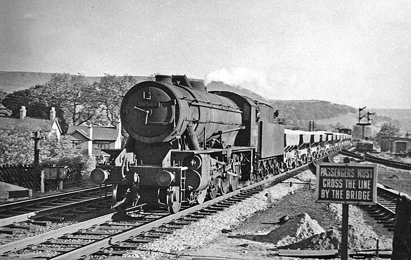
View southward, towards Peak Forest, Matlock and Derby; ex-Midland main line, Derby - Matlock - Chinley - Manchester. This station at Chapel-en-le-Frith was closed on 6/3/67 when the whole Peak Line (Matlock - Manchester) was closed, but the line Peak Forest - Chinley has been kept open to serve the
1026:== {{int:filedesc}} == {{Information |Description={{en|1=Down ballast train at Chapel-en-le-Frith Central Station View southward, towards Peak Forest, Matlock and Derby; ex-Midland main line, Derby - Matlock - Chinley - Manchester. This station at Chapel-
211:
353:– You must give appropriate credit, provide a link to the license, and indicate if changes were made. You may do so in any reasonable manner, but not in any way that suggests the licensor endorses you or your use.
57:
53:
47:
102:
70:
670:
1045:
1120:
189:
842:
605:
569:
533:
235:
655:
270:
1076:
This file contains additional information, probably added from the digital camera or scanner used to create or digitize it.
360:
496:
1008:
1003:
61:
42:
937:
900:
863:
808:
774:
711:
684:
633:
589:
517:
489:
476:
461:
835:
740:
648:
618:
553:
434:
417:
257:
316:
1079:
If the file has been modified from its original state, some details may not fully reflect the modified file.
1036:
The following pages on the
English Knowledge (XXG) use this file (pages on other projects are not listed):
359:– If you remix, transform, or build upon the material, you must distribute your contributions under the
277:
on the
Geograph website for the photographer's contact details. The copyright on this image is owned by
313:
677:"}},"text\/plain":{"en":{"P7787":"202 degree"}}}}": -->
1040:
110:
1063:
640:
625:
468:
241:
282:
97:
225:
1135:
1019:
178:
168:
262:
150:
limestone quarries. The locomotive is ex-War
Department 2-8-0 No. 90539.
274:
976:
Click on a date/time to view the file as it appeared at that time.
227:
212:
53° 19′ 29.97″ N, 1° 55′ 09.08″ W
202:
85:
146:
Down ballast train at Chapel-en-le-Frith
Central Station.
401:
Add a one-line explanation of what this file represents
135:
Chapel-en-le-Frith
Central Station geograph-2147803.jpg
196:
Creative
Commons Attribution Share-alike license 2.0
129:
109:
Commons is a freely licensed media file repository.
570:
Creative
Commons Attribution-ShareAlike 2.0 Generic
75:(1,024 × 648 pixels, file size: 191 KB, MIME type:
370:https://creativecommons.org/licenses/by-sa/2.0
90:
376:Creative Commons Attribution-Share Alike 2.0
294:
8:
674:
336:– to copy, distribute and transmit the work
1081:
1046:Chapel-en-le-Frith Central railway station
978:
397:
1056:The following other wikis use this file:
626:https://www.geograph.org.uk/photo/2147803
469:https://www.geograph.org.uk/profile/44502
824:26d9f0315ad8526c82b352e0494bcdf52661a250
1133:
1125:
1115:
1107:
1099:
1091:
1083:
1038:
951:
935:
914:
898:
877:
861:
822:
806:
788:
772:
754:
738:
698:
682:
603:
587:
567:
551:
531:
515:
448:
432:
415:
412:
393:
386:
205:
234:View this and other nearby images on:
7:
1121:Adobe Photoshop Elements 3.0 Windows
281:and is licensed for reuse under the
967:
317:Attribution-Share Alike 2.0 Generic
305:
300:
285:Attribution-ShareAlike 2.0 license.
1074:
406:
400:
291:
268:
139:
122:
68:
405:
685:coordinates of the point of view
391:
347:Under the following conditions:
312:This file is licensed under the
304:
299:
293:
261:
240:
226:
218:
89:
31:
21:
388:
140:
14:
606:file available on the internet
387:
269:This image was taken from the
26:
1:
36:
700:53°19'29.975"N, 1°55'9.080"W
656:Geograph Britain and Ireland
490:object of statement has role
413:Items portrayed in this file
217:
1060:Usage on azb.wikipedia.org
1157:
361:same or compatible license
159:Taken on 19 June 1957
1127:File change date and time
968:
16:
634:geograph.org.uk image ID
390:
327:
96:This is a file from the
1025:
184:
174:
163:
158:
155:
132:
100:. Information from its
1130:11:58, 6 November 2010
1004:17:09, 8 November 2010
275:this photograph's page
246:53.324993; -1.919189
103:description page there
46:Size of this preview:
1101:Horizontal resolution
836:determination method
1109:Vertical resolution
1088:EPSON scanner image
342:– to adapt the work
52:Other resolutions:
1041:Chapel-en-le-Frith
477:author name string
62:1,024 × 648 pixels
1144:
1143:
1052:Global file usage
1029:
676:
554:copyright license
399:
290:
289:
273:collection. See
251:
250:
200:
199:
193:
190:Reusing this file
118:
117:
98:Wikimedia Commons
32:Global file usage
1148:
1082:
1016:
956:
919:
882:
845:
840:
722:
721:
716:
658:
653:
643:
638:
628:
623:
619:described at URL
518:copyright status
499:
494:
484:
481:
471:
466:
383:
380:
377:
374:
371:
363:as the original.
325:
314:Creative Commons
308:
307:
303:
302:
297:
296:
283:Creative Commons
271:Geograph project
265:
258:
247:
244:
230:
229:
223:
222:
221:
215:
214:
203:
187:
144:
136:
130:
114:
93:
92:
86:
80:
78:
65:
58:640 × 405 pixels
54:320 × 203 pixels
48:800 × 506 pixels
1156:
1155:
1151:
1150:
1149:
1147:
1146:
1145:
1070:
1050:
1037:
1030:
1022:
1014:
970:
969:
966:
965:
964:
963:
962:
961:
960:
959:
957:
954:
944:
943:
942:
940:
929:
928:
927:
926:
925:
924:
923:
922:
920:
917:
907:
906:
905:
903:
892:
891:
890:
889:
888:
887:
886:
885:
883:
880:
870:
869:
868:
866:
855:
854:
853:
852:
851:
850:
849:
848:
847:
846:
841:
838:
829:
828:
827:
825:
815:
814:
813:
811:
800:
799:
798:
797:
796:
795:
794:
793:
791:
781:
780:
779:
777:
766:
765:
764:
763:
762:
761:
760:
759:
757:
747:
746:
745:
743:
732:
731:
730:
729:
728:
727:
726:
725:
724:
723:
719:
717:
714:
705:
704:
703:
701:
691:
690:
689:
687:
668:
667:
666:
665:
664:
663:
662:
661:
660:
659:
654:
651:
645:
644:
639:
636:
630:
629:
624:
621:
612:
611:
610:
608:
596:
595:
594:
592:
581:
580:
579:
578:
577:
576:
575:
574:
572:
560:
559:
558:
556:
545:
544:
543:
542:
541:
540:
539:
538:
536:
524:
523:
522:
520:
509:
508:
507:
506:
505:
504:
503:
502:
501:
500:
495:
492:
486:
485:
482:
479:
473:
472:
467:
464:
455:
454:
453:
451:
441:
440:
439:
437:
426:
425:
424:
423:
422:
420:
404:
403:
402:
385:
384:
381:
378:
375:
372:
369:
368:
326:
323:
320:
309:
286:
256:
245:
219:
210:
209:
206:Camera location
201:
169:geograph.org.uk
151:
134:
127:
120:
119:
108:
107:
106:is shown below.
82:
76:
74:
67:
66:
51:
12:
11:
5:
1154:
1152:
1142:
1141:
1138:
1132:
1131:
1128:
1124:
1123:
1118:
1114:
1113:
1110:
1106:
1105:
1102:
1098:
1097:
1094:
1090:
1089:
1086:
1073:
1069:
1068:
1067:
1066:
1054:
1053:
1049:
1048:
1043:
1035:
1034:
1033:
1028:
1027:
1024:
1020:
1017:
1011:
1006:
1001:
997:
996:
993:
990:
987:
984:
981:
974:
973:
958:
952:
950:
949:
948:
947:
946:
945:
941:
936:
934:
933:
932:
931:
930:
921:
915:
913:
912:
911:
910:
909:
908:
904:
899:
897:
896:
895:
894:
893:
884:
878:
876:
875:
874:
873:
872:
871:
867:
862:
860:
859:
858:
857:
856:
834:
833:
832:
831:
830:
826:
823:
821:
820:
819:
818:
817:
816:
812:
807:
805:
804:
803:
802:
801:
792:
789:
787:
786:
785:
784:
783:
782:
778:
773:
771:
770:
769:
768:
767:
758:
755:
753:
752:
751:
750:
749:
748:
744:
739:
737:
736:
735:
734:
733:
710:
709:
708:
707:
706:
702:
699:
697:
696:
695:
694:
693:
692:
688:
683:
681:
680:
679:
678:
672:
647:
646:
632:
631:
617:
616:
615:
614:
613:
609:
604:
602:
601:
600:
599:
598:
597:
593:
590:source of file
588:
586:
585:
584:
583:
582:
573:
568:
566:
565:
564:
563:
562:
561:
557:
552:
550:
549:
548:
547:
546:
537:
532:
530:
529:
528:
527:
526:
525:
521:
516:
514:
513:
512:
511:
510:
488:
487:
483:Ben Brooksbank
475:
474:
460:
459:
458:
457:
456:
452:
449:
447:
446:
445:
444:
443:
442:
438:
433:
431:
430:
429:
428:
427:
421:
416:
414:
411:
410:
409:
408:
407:
396:
395:
392:
389:
367:
366:
365:
364:
354:
345:
344:
343:
337:
330:You are free:
324:Ben Brooksbank
321:
311:
310:
292:
288:
287:
279:Ben Brooksbank
266:
255:
252:
249:
248:
238:
232:
207:
198:
197:
194:
182:
181:
179:Ben Brooksbank
176:
172:
171:
165:
161:
160:
157:
153:
152:
137:
128:
126:
123:
121:
116:
115:
94:
84:
83:
45:
41:
40:
39:
34:
29:
24:
19:
13:
10:
9:
6:
4:
3:
2:
1153:
1139:
1137:
1134:
1129:
1126:
1122:
1119:
1117:Software used
1116:
1111:
1108:
1103:
1100:
1095:
1092:
1087:
1084:
1080:
1077:
1071:
1065:
1062:
1061:
1059:
1058:
1057:
1051:
1047:
1044:
1042:
1039:
1031:
1023:
1018:
1012:
1010:
1007:
1005:
1002:
999:
998:
994:
991:
988:
985:
982:
980:
979:
977:
971:
939:
902:
865:
844:
837:
810:
776:
742:
713:
686:
657:
650:
642:
635:
627:
620:
607:
591:
571:
555:
535:
519:
498:
491:
478:
470:
463:
436:
419:
373:CC BY-SA 2.0
362:
358:
355:
352:
349:
348:
346:
341:
338:
335:
332:
331:
329:
328:
322:Attribution:
318:
315:
298:
284:
280:
276:
272:
267:
264:
260:
259:
253:
243:
239:
237:
236:OpenStreetMap
233:
231:
213:
208:
204:
195:
191:
186:
183:
180:
177:
173:
170:
166:
162:
154:
148:
147:
143:
138:
131:
124:
112:
105:
104:
99:
95:
88:
87:
81:
72:
71:Original file
63:
59:
55:
49:
44:
38:
35:
33:
30:
28:
25:
23:
20:
18:
15:
1140:Uncalibrated
1078:
1075:
1055:
1013:1,024 × 648
975:
972:File history
756:19 June 1957
497:photographer
356:
350:
339:
333:
278:
216:
145:
141:
111:You can help
101:
69:
22:File history
1136:Color space
1093:Orientation
1085:Image title
534:copyrighted
357:share alike
351:attribution
133:Description
1032:File usage
989:Dimensions
790:image/jpeg
775:media type
450:some value
185:Permission
77:image/jpeg
27:File usage
986:Thumbnail
983:Date/Time
864:data size
741:inception
254:Licensing
142:English:
1072:Metadata
1064:پورتسموث
1015:(191 KB)
879:195,385
809:checksum
649:operator
394:Captions
340:to remix
334:to share
319:license.
37:Metadata
1112:157 dpc
1104:157 dpc
1000:current
995:Comment
712:heading
671:heading
641:2147803
435:creator
418:depicts
398:English
125:Summary
73:
1096:Normal
1021:Chevin
953:1,024
901:height
720:degree
675:degree
224:
175:Author
164:Source
955:pixel
938:width
918:pixel
843:SHA-1
167:From
992:User
916:648
881:byte
718:202
382:true
379:true
156:Date
17:File
462:URL
839::
715::
652::
637::
622::
493::
480::
465::
60:|
56:|
50:.
192:)
188:(
113:.
79:)
64:.
Text is available under the Creative Commons Attribution-ShareAlike License. Additional terms may apply.

