38:
254:
221:
235:
260:
265:
98:
762:
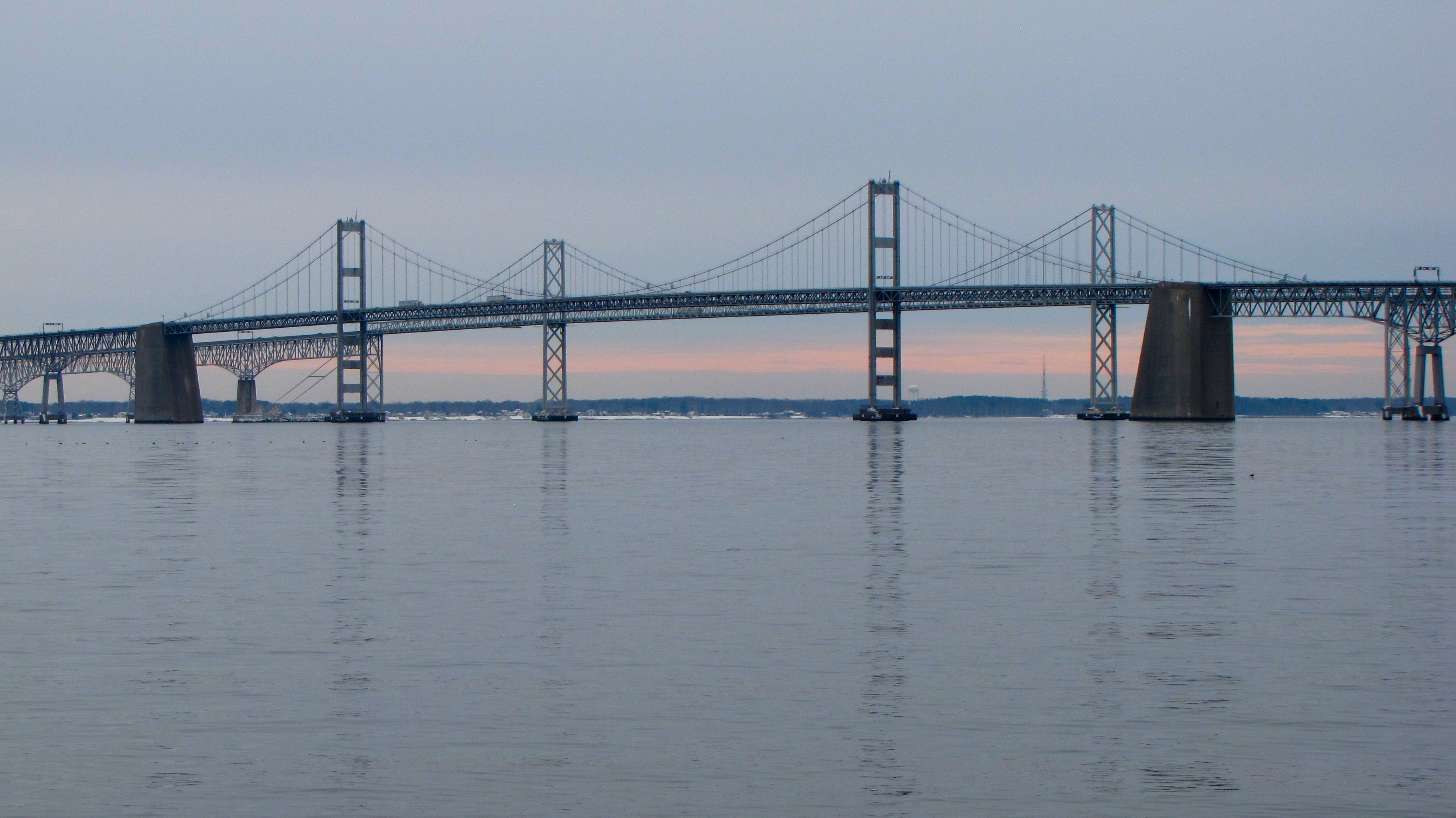
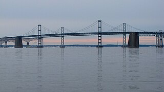
779:{{Information |Description ={{en|1=The Chesapeake Bay Bridge as viewed from Sandy Point State Park in Anne Arundel County, Maryland.}} |Source =Own work |Author =Ben Schumin |Date =2011-01-29 |Permission =Own work |other_v
212:
306:– You must give appropriate credit, provide a link to the license, and indicate if changes were made. You may do so in any reasonable manner, but not in any way that suggests the licensor endorses you or your use.
841:
64:
60:
56:
52:
48:
42:
109:
77:
808:
831:
190:
876:
595:
439:
403:
228:
761:
756:
68:
37:
313:
690:
653:
616:
561:
527:
493:
387:
588:
459:
423:
370:
275:
886:
793:
312:– If you remix, transform, or build upon the material, you must distribute your contributions under the
803:
272:
152:
The
Chesapeake Bay Bridge as viewed from Sandy Point State Park in Anne Arundel County, Maryland.
117:
813:
772:
234:
851:
104:
866:
218:
161:
798:
729:
Click on a date/time to view the file as it appeared at that time.
486:
220:
213:
39° 00′ 36.7″ N, 76° 23′ 54.1″ W
203:
92:
142:
Chesapeake Bay Bridge viewed from Sandy Point State Park.jpg
809:
Template:Did you know nominations/Chesapeake Bay Bridge
354:
Add a one-line explanation of what this file represents
82:(3,648 × 2,052 pixels, file size: 1.05 MB, MIME type:
861:
440:
Creative
Commons Attribution-ShareAlike 3.0 Unported
136:
116:
Commons is a freely licensed media file repository.
323:https://creativecommons.org/licenses/by-sa/3.0
97:
329:Creative Commons Attribution-Share Alike 3.0
253:
8:
289:– to copy, distribute and transmit the work
731:
350:
852:Benutzer:Icodense99/Chesapeake Bay Bridge
824:The following other wikis use this file:
577:1fbb54d1f34f0978e5d4b521267c0510ac0cb176
791:
704:
688:
667:
651:
630:
614:
575:
559:
541:
525:
507:
491:
473:
457:
437:
421:
401:
385:
368:
365:
346:
339:
206:
227:View this and other nearby images on:
789:The following 5 pages use this file:
7:
276:Attribution-Share Alike 3.0 Unported
720:
264:
259:
359:
353:
250:
146:
129:
75:
358:
867:Puente de la Bahía de Chesapeake
494:coordinates of the point of view
344:
300:Under the following conditions:
271:This file is licensed under the
263:
258:
252:
233:
219:
96:
31:
21:
341:
147:
14:
340:
26:
1:
509:39°0'36.698"N, 76°23'54.100"W
366:Items portrayed in this file
905:
883:Usage on zh.wikipedia.org
873:Usage on ko.wikipedia.org
858:Usage on es.wikipedia.org
848:Usage on de.wikipedia.org
838:Usage on bn.wikipedia.org
828:Usage on ar.wikipedia.org
314:same or compatible license
721:
171:
16:
343:
280:
103:This is a file from the
778:
185:
177:
167:
160:
157:
139:
107:. Information from its
757:20:46, 30 January 2011
239:39.010194; -76.398361
110:description page there
41:Size of this preview:
794:Chesapeake Bay Bridge
804:User:Michael.shipley
589:determination method
69:3,648 × 2,052 pixels
65:2,560 × 1,440 pixels
842:চেসেপিক উপসাগর সেতু
295:– to adapt the work
47:Other resolutions:
61:1,280 × 720 pixels
57:1,024 × 576 pixels
832:جسر خليج تشيسابيك
820:Global file usage
782:
424:copyright license
352:
244:
243:
201:
200:
194:
191:Reusing this file
125:
124:
105:Wikimedia Commons
32:Global file usage
896:
769:
709:
672:
635:
598:
593:
388:copyright status
336:
333:
330:
327:
324:
316:as the original.
273:Creative Commons
267:
266:
262:
261:
256:
255:
240:
237:
223:
222:
216:
215:
204:
188:
173:
163:
151:
143:
137:
121:
100:
99:
93:
87:
85:
72:
53:640 × 360 pixels
49:320 × 180 pixels
43:800 × 450 pixels
904:
903:
899:
898:
897:
895:
894:
893:
818:
814:Portal:Maryland
783:
775:
767:
723:
722:
719:
718:
717:
716:
715:
714:
713:
712:
710:
707:
697:
696:
695:
693:
682:
681:
680:
679:
678:
677:
676:
675:
673:
670:
660:
659:
658:
656:
645:
644:
643:
642:
641:
640:
639:
638:
636:
633:
623:
622:
621:
619:
608:
607:
606:
605:
604:
603:
602:
601:
600:
599:
594:
591:
582:
581:
580:
578:
568:
567:
566:
564:
553:
552:
551:
550:
549:
548:
547:
546:
544:
534:
533:
532:
530:
519:
518:
517:
516:
515:
514:
513:
512:
510:
500:
499:
498:
496:
485:
484:
483:
482:
481:
480:
479:
478:
476:
475:29 January 2011
466:
465:
464:
462:
451:
450:
449:
448:
447:
446:
445:
444:
442:
430:
429:
428:
426:
415:
414:
413:
412:
411:
410:
409:
408:
406:
394:
393:
392:
390:
379:
378:
377:
376:
375:
373:
357:
356:
355:
338:
337:
334:
331:
328:
325:
322:
321:
279:
268:
249:
238:
211:
210:
207:Camera location
202:
162:29 January 2011
153:
141:
134:
127:
126:
115:
114:
113:is shown below.
89:
83:
81:
74:
73:
46:
12:
11:
5:
902:
900:
892:
891:
890:
889:
881:
880:
879:
871:
870:
869:
864:
856:
855:
854:
846:
845:
844:
836:
835:
834:
822:
821:
817:
816:
811:
806:
801:
796:
787:
786:
781:
780:
777:
773:
770:
766:3,648 × 2,052
764:
759:
754:
750:
749:
746:
743:
740:
737:
734:
727:
726:
711:
705:
703:
702:
701:
700:
699:
698:
694:
689:
687:
686:
685:
684:
683:
674:
668:
666:
665:
664:
663:
662:
661:
657:
652:
650:
649:
648:
647:
646:
637:
631:
629:
628:
627:
626:
625:
624:
620:
615:
613:
612:
611:
610:
609:
587:
586:
585:
584:
583:
579:
576:
574:
573:
572:
571:
570:
569:
565:
560:
558:
557:
556:
555:
554:
545:
542:
540:
539:
538:
537:
536:
535:
531:
526:
524:
523:
522:
521:
520:
511:
508:
506:
505:
504:
503:
502:
501:
497:
492:
490:
489:
488:
487:
477:
474:
472:
471:
470:
469:
468:
467:
463:
458:
456:
455:
454:
453:
452:
443:
438:
436:
435:
434:
433:
432:
431:
427:
422:
420:
419:
418:
417:
416:
407:
402:
400:
399:
398:
397:
396:
395:
391:
386:
384:
383:
382:
381:
380:
374:
369:
367:
364:
363:
362:
361:
360:
349:
348:
345:
342:
320:
319:
318:
317:
307:
298:
297:
296:
290:
283:You are free:
270:
269:
251:
248:
245:
242:
241:
231:
225:
208:
199:
198:
195:
183:
182:
179:
175:
174:
169:
165:
164:
159:
155:
154:
144:
135:
133:
130:
128:
123:
122:
101:
91:
90:
40:
36:
35:
34:
29:
24:
19:
13:
10:
9:
6:
4:
3:
2:
901:
888:
885:
884:
882:
878:
875:
874:
872:
868:
865:
863:
860:
859:
857:
853:
850:
849:
847:
843:
840:
839:
837:
833:
830:
829:
827:
826:
825:
819:
815:
812:
810:
807:
805:
802:
800:
797:
795:
792:
790:
784:
776:
771:
765:
763:
760:
758:
755:
752:
751:
747:
744:
741:
738:
735:
733:
732:
730:
724:
692:
655:
618:
597:
590:
563:
529:
495:
461:
441:
425:
405:
389:
372:
326:CC BY-SA 3.0
315:
311:
308:
305:
302:
301:
299:
294:
291:
288:
285:
284:
282:
281:
277:
274:
257:
246:
236:
232:
230:
229:OpenStreetMap
226:
224:
214:
209:
205:
196:
192:
187:
184:
180:
176:
170:
166:
156:
150:
145:
138:
131:
119:
112:
111:
106:
102:
95:
94:
88:
79:
78:Original file
70:
66:
62:
58:
54:
50:
44:
39:
33:
30:
28:
25:
23:
20:
18:
15:
823:
788:
728:
725:File history
309:
303:
292:
286:
148:
118:You can help
108:
76:
22:File history
877:체서피크 베이 브리지
404:copyrighted
310:share alike
304:attribution
181:Ben Schumin
140:Description
785:File usage
774:SchuminWeb
742:Dimensions
632:1,100,536
543:image/jpeg
528:media type
186:Permission
84:image/jpeg
27:File usage
768:(1.05 MB)
739:Thumbnail
736:Date/Time
617:data size
460:inception
247:Licensing
149:English:
862:Maryland
799:Maryland
562:checksum
347:Captions
293:to remix
287:to share
278:license.
197:Own work
172:Own work
887:切萨皮克湾大桥
753:current
748:Comment
371:depicts
351:English
132:Summary
80:
706:3,648
669:2,052
654:height
217:
178:Author
168:Source
708:pixel
691:width
671:pixel
596:SHA-1
745:User
634:byte
335:true
332:true
158:Date
17:File
592::
67:|
63:|
59:|
55:|
51:|
45:.
193:)
189:(
120:.
86:)
71:.
Text is available under the Creative Commons Attribution-ShareAlike License. Additional terms may apply.