43:
172:
302:
263:
255:
393:
277:
308:
313:
99:
663:"}},"text\/plain":{"en":{"":"heading"}}},"{\"value\":{\"amount\":\"+168.75\",\"unit\":\"http:\\\/\\\/www.wikidata.org\\\/entity\\\/Q28390\"},\"type\":\"quantity\"}":{"text\/html":{"en":{"P7787":"168.75
659:
1203:
246:
354:– You must give appropriate credit, provide a link to the license, and indicate if changes were made. You may do so in any reasonable manner, but not in any way that suggests the licensor endorses you or your use.
65:
61:
57:
53:
47:
110:
660:
78:
410:
1198:
179:
162:
1171:
408:; with no Invariant Sections, no Front-Cover Texts, and no Back-Cover Texts. A copy of the license is included in the section entitled
400:
978:
646:
576:
559:
523:
270:
1236:
487:
1387:
1269:
This file contains additional information, probably added from the digital camera or scanner used to create or digitize it.
782:
746:
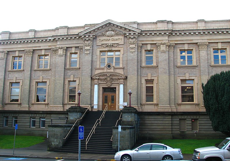
1162:{{Information |Description={{en|1=The historic Clatsop County Courthouse (built 1904), located at 749 Commercial Street in
361:
1073:
1036:
999:
944:
910:
873:
839:
802:
766:
730:
701:
674:
630:
507:
405:
971:
596:
543:
471:
1188:
1144:
1139:
69:
42:
323:
1272:
If the file has been modified from its original state, some details may not fully reflect the modified file.
1184:
The following pages on the
English Knowledge (XXG) use this file (pages on other projects are not listed):
1432:
1291:
360:– If you remix, transform, or build upon the material, you must distribute your contributions under the
667:"}},"text\/plain":{"en":{"P7787":"168.75 degree"}}}}": -->
1155:
320:
1460:
118:
387:
398:
Permission is granted to copy, distribute and/or modify this document under the terms of the
154:
1193:
1281:
1163:
153:
The historic
Clatsop County Courthouse (built 1904), located at 749 Commercial Street in
158:
276:
188:
1528:
1450:
1414:
1298:
1167:
295:
I, the copyright holder of this work, hereby publish it under the following licenses:
105:
1538:
1327:
260:
228:
1470:
207:
166:
1364:
1237:
Liste der Einträge im
National Register of Historic Places im Clatsop County
1308:
1204:
National
Register of Historic Places listings in Clatsop County, Oregon
1221:
1112:
Click on a date/time to view the file as it appeared at that time.
247:
46° 11′ 21.18″ N, 123° 50′ 07.07″ W
183:
262:
237:
178:
This is an image of a place or building that is listed on the
93:
1246:
1231:
455:
Add a one-line explanation of what this file represents
1256:
83:(2,592 × 1,822 pixels, file size: 1.5 MB, MIME type:
577:
Creative
Commons Attribution-ShareAlike 3.0 Unported
560:
404:, Version 1.2 or any later version published by the
137:
117:
Commons is a freely licensed media file repository.
1465:Flash did not fire, compulsory flash suppression
371:https://creativecommons.org/licenses/by-sa/3.0
143:Clatsop County Courthouse - Astoria Oregon.jpg
98:
377:Creative Commons Attribution-Share Alike 3.0
301:
8:
664:
337:– to copy, distribute and transmit the work
1274:
1114:
451:
436:You may select the license of your choice.
1214:The following other wikis use this file:
1199:List of courthouses in the United States
960:2ee1591985c83aedeece759bc5d2c3a890553b2c
1555:
1547:
1536:
1526:
1518:
1510:
1502:
1494:
1486:
1478:
1468:
1458:
1448:
1440:
1430:
1422:
1412:
1404:
1396:
1385:
1377:
1369:
1359:
1351:
1343:
1335:
1324:
1316:
1306:
1296:
1286:
1186:
1172:en:National Register of Historic Places
1087:
1071:
1050:
1034:
1013:
997:
958:
942:
924:
908:
887:
871:
853:
837:
816:
800:
780:
764:
744:
728:
688:
672:
644:
628:
610:
594:
574:
557:
541:
521:
505:
485:
469:
466:
447:
440:
240:
269:View this and other nearby images on:
1276:
7:
416:http://www.gnu.org/copyleft/fdl.html
324:Attribution-Share Alike 3.0 Unported
180:National Register of Historic Places
163:National Register of Historic Places
1103:
312:
307:
1267:
460:
454:
435:
298:
294:
147:
130:
76:
459:
1560:963961a3877bf6516caec843bf8d1e21
1318:Date and time of data generation
675:coordinates of the point of view
445:
392:
391:
348:Under the following conditions:
319:This file is licensed under the
311:
306:
300:
275:
261:
253:
170:
97:
31:
21:
442:
252:
148:
14:
690:46°11'21.181"N, 123°50'7.069"W
441:
422:GNU Free Documentation License
411:GNU Free Documentation License
401:GNU Free Documentation License
26:
1:
647:original creation by uploader
36:
467:Items portrayed in this file
1496:Focal plane resolution unit
1398:Date and time of digitizing
1218:Usage on bar.wikipedia.org
1577:
1507:One-chip color area sensor
1253:Usage on www.wikidata.org
1243:Usage on nl.wikipedia.org
1228:Usage on de.wikipedia.org
362:same or compatible license
186:. Its reference number is
1371:File change date and time
1189:Clatsop County Courthouse
1104:
488:Clatsop County Courthouse
217:
16:
1488:Focal plane Y resolution
1480:Focal plane X resolution
444:
406:Free Software Foundation
328:
184:United States of America
104:This is a file from the
1512:Custom image processing
1401:12:38, 25 February 2010
1374:12:38, 25 February 2010
1321:12:38, 25 February 2010
1161:
223:
213:
206:
203:
140:
108:. Information from its
1406:Image compression mode
1222:Clatsop County, Oregon
1170:, is listed on the US
281:46.189217; -123.835297
161:, is listed on the US
111:description page there
46:Size of this preview:
1442:Maximum land aperture
1345:Horizontal resolution
1292:Canon PowerShot S2 IS
747:Canon PowerShot S2 IS
1533:Manual white balance
972:determination method
767:location of creation
70:2,592 × 1,822 pixels
1445:2.875 APEX (f/2.71)
1379:Y and C positioning
1353:Vertical resolution
1278:Camera manufacturer
1140:05:16, 6 March 2010
343:– to adapt the work
52:Other resolutions:
1549:Scene capture type
66:1,280 × 900 pixels
62:1,024 × 720 pixels
1564:
1563:
1303:1/125 sec (0.008)
1210:Global file usage
1177:
666:
544:copyright license
453:
433:
432:
286:
285:
235:
234:
198:
197:
126:
125:
106:Wikimedia Commons
32:Global file usage
1568:
1491:11,571.428571429
1275:
1194:Edgar M. Lazarus
1168:en:United States
1152:
1092:
1055:
1018:
981:
976:
892:
821:
712:
711:
706:
612:25 February 2010
508:copyright status
429:
426:
423:
420:
417:
395:
394:
388:
384:
381:
378:
375:
372:
364:as the original.
321:Creative Commons
315:
314:
310:
309:
304:
303:
282:
279:
265:
264:
258:
257:
256:
250:
249:
238:
219:
209:
208:25 February 2010
191:
174:
173:
167:
152:
144:
138:
122:
101:
100:
94:
88:
86:
73:
58:640 × 450 pixels
54:320 × 225 pixels
48:800 × 562 pixels
1576:
1575:
1571:
1570:
1569:
1567:
1566:
1565:
1557:Unique image ID
1263:
1208:
1185:
1178:
1164:Astoria, Oregon
1158:
1150:
1106:
1105:
1102:
1101:
1100:
1099:
1098:
1097:
1096:
1095:
1093:
1090:
1080:
1079:
1078:
1076:
1065:
1064:
1063:
1062:
1061:
1060:
1059:
1058:
1056:
1053:
1043:
1042:
1041:
1039:
1028:
1027:
1026:
1025:
1024:
1023:
1022:
1021:
1019:
1016:
1006:
1005:
1004:
1002:
991:
990:
989:
988:
987:
986:
985:
984:
983:
982:
977:
974:
965:
964:
963:
961:
951:
950:
949:
947:
936:
935:
934:
933:
932:
931:
930:
929:
927:
917:
916:
915:
913:
902:
901:
900:
899:
898:
897:
896:
895:
893:
890:
880:
879:
878:
876:
865:
864:
863:
862:
861:
860:
859:
858:
856:
846:
845:
844:
842:
831:
830:
829:
828:
827:
826:
825:
824:
822:
819:
809:
808:
807:
805:
794:
793:
792:
791:
790:
789:
788:
787:
785:
773:
772:
771:
769:
758:
757:
756:
755:
754:
753:
752:
751:
749:
737:
736:
735:
733:
722:
721:
720:
719:
718:
717:
716:
715:
714:
713:
709:
707:
704:
695:
694:
693:
691:
681:
680:
679:
677:
658:
657:
656:
655:
654:
653:
652:
651:
649:
637:
636:
635:
633:
622:
621:
620:
619:
618:
617:
616:
615:
613:
603:
602:
601:
599:
588:
587:
586:
585:
584:
583:
582:
581:
579:
568:
567:
566:
565:
564:
562:
550:
549:
548:
546:
535:
534:
533:
532:
531:
530:
529:
528:
526:
514:
513:
512:
510:
499:
498:
497:
496:
495:
494:
493:
492:
490:
478:
477:
476:
474:
458:
457:
456:
439:
438:
437:
427:
424:
421:
418:
415:
386:
385:
382:
379:
376:
373:
370:
369:
327:
316:
297:
296:
291:
280:
254:
245:
244:
241:Camera location
236:
229:User:Werewombat
199:
187:
171:
155:Astoria, Oregon
142:
135:
128:
127:
116:
115:
114:is shown below.
90:
84:
82:
75:
74:
51:
12:
11:
5:
1574:
1572:
1562:
1561:
1558:
1554:
1553:
1550:
1546:
1545:
1542:
1535:
1534:
1531:
1525:
1524:
1521:
1517:
1516:
1515:Normal process
1513:
1509:
1508:
1505:
1504:Sensing method
1501:
1500:
1497:
1493:
1492:
1489:
1485:
1484:
1481:
1477:
1476:
1473:
1467:
1466:
1463:
1457:
1456:
1453:
1447:
1446:
1443:
1439:
1438:
1435:
1429:
1428:
1425:
1421:
1420:
1417:
1411:
1410:
1407:
1403:
1402:
1399:
1395:
1394:
1391:
1384:
1383:
1380:
1376:
1375:
1372:
1368:
1367:
1362:
1358:
1357:
1354:
1350:
1349:
1346:
1342:
1341:
1338:
1334:
1333:
1330:
1323:
1322:
1319:
1315:
1314:
1311:
1305:
1304:
1301:
1295:
1294:
1289:
1285:
1284:
1279:
1266:
1262:
1261:
1260:
1259:
1251:
1250:
1249:
1247:Clatsop County
1241:
1240:
1239:
1234:
1232:Clatsop County
1226:
1225:
1224:
1212:
1211:
1207:
1206:
1201:
1196:
1191:
1183:
1182:
1181:
1176:
1175:
1160:
1156:
1153:
1149:2,592 × 1,822
1147:
1142:
1137:
1133:
1132:
1129:
1126:
1123:
1120:
1117:
1110:
1109:
1094:
1088:
1086:
1085:
1084:
1083:
1082:
1081:
1077:
1072:
1070:
1069:
1068:
1067:
1066:
1057:
1051:
1049:
1048:
1047:
1046:
1045:
1044:
1040:
1035:
1033:
1032:
1031:
1030:
1029:
1020:
1014:
1012:
1011:
1010:
1009:
1008:
1007:
1003:
998:
996:
995:
994:
993:
992:
970:
969:
968:
967:
966:
962:
959:
957:
956:
955:
954:
953:
952:
948:
943:
941:
940:
939:
938:
937:
928:
925:
923:
922:
921:
920:
919:
918:
914:
909:
907:
906:
905:
904:
903:
894:
888:
886:
885:
884:
883:
882:
881:
877:
872:
870:
869:
868:
867:
866:
857:
854:
852:
851:
850:
849:
848:
847:
843:
838:
836:
835:
834:
833:
832:
823:
817:
815:
814:
813:
812:
811:
810:
806:
801:
799:
798:
797:
796:
795:
786:
781:
779:
778:
777:
776:
775:
774:
770:
765:
763:
762:
761:
760:
759:
750:
745:
743:
742:
741:
740:
739:
738:
734:
729:
727:
726:
725:
724:
723:
700:
699:
698:
697:
696:
692:
689:
687:
686:
685:
684:
683:
682:
678:
673:
671:
670:
669:
668:
662:
650:
645:
643:
642:
641:
640:
639:
638:
634:
631:source of file
629:
627:
626:
625:
624:
623:
614:
611:
609:
608:
607:
606:
605:
604:
600:
595:
593:
592:
591:
590:
589:
580:
575:
573:
572:
571:
570:
569:
563:
558:
556:
555:
554:
553:
552:
551:
547:
542:
540:
539:
538:
537:
536:
527:
522:
520:
519:
518:
517:
516:
515:
511:
506:
504:
503:
502:
501:
500:
491:
486:
484:
483:
482:
481:
480:
479:
475:
470:
468:
465:
464:
463:
462:
461:
450:
449:
446:
443:
434:
431:
430:
396:
368:
367:
366:
365:
355:
346:
345:
344:
338:
331:You are free:
318:
317:
299:
293:
292:
290:
287:
284:
283:
273:
267:
242:
233:
232:
225:
221:
220:
215:
211:
210:
205:
201:
200:
196:
195:
175:
145:
136:
134:
131:
129:
124:
123:
102:
92:
91:
45:
41:
40:
39:
34:
29:
24:
19:
13:
10:
9:
6:
4:
3:
2:
1573:
1559:
1556:
1551:
1548:
1543:
1540:
1537:
1532:
1530:
1529:White balance
1527:
1523:Auto exposure
1522:
1520:Exposure mode
1519:
1514:
1511:
1506:
1503:
1498:
1495:
1490:
1487:
1482:
1479:
1474:
1472:
1469:
1464:
1462:
1459:
1454:
1452:
1451:Metering mode
1449:
1444:
1441:
1436:
1434:
1433:Exposure bias
1431:
1426:
1424:APEX aperture
1423:
1418:
1416:
1415:Shutter speed
1413:
1408:
1405:
1400:
1397:
1392:
1389:
1386:
1381:
1378:
1373:
1370:
1366:
1363:
1361:Software used
1360:
1355:
1352:
1347:
1344:
1339:
1336:
1331:
1329:
1325:
1320:
1317:
1312:
1310:
1307:
1302:
1300:
1299:Exposure time
1297:
1293:
1290:
1287:
1283:
1280:
1277:
1273:
1270:
1264:
1258:
1255:
1254:
1252:
1248:
1245:
1244:
1242:
1238:
1235:
1233:
1230:
1229:
1227:
1223:
1220:
1219:
1217:
1216:
1215:
1209:
1205:
1202:
1200:
1197:
1195:
1192:
1190:
1187:
1179:
1173:
1169:
1165:
1159:
1154:
1148:
1146:
1143:
1141:
1138:
1135:
1134:
1130:
1127:
1124:
1121:
1118:
1116:
1115:
1113:
1107:
1075:
1038:
1001:
980:
973:
946:
912:
875:
841:
804:
803:exposure time
784:
768:
748:
732:
731:captured with
703:
676:
648:
632:
598:
578:
561:
545:
525:
509:
489:
473:
413:
412:
407:
403:
402:
397:
390:
389:
374:CC BY-SA 3.0
363:
359:
356:
353:
350:
349:
347:
342:
339:
336:
333:
332:
330:
329:
325:
322:
305:
288:
278:
274:
272:
271:OpenStreetMap
268:
266:
248:
243:
239:
230:
227:Ian Poellet (
226:
222:
216:
212:
202:
194:
193:
190:
185:
181:
176:
169:
168:
164:
160:
159:United States
156:
151:
146:
139:
132:
120:
113:
112:
107:
103:
96:
95:
89:
80:
79:Original file
71:
67:
63:
59:
55:
49:
44:
38:
35:
33:
30:
28:
25:
23:
20:
18:
15:
1539:Digital zoom
1475:Uncalibrated
1328:focal length
1288:Camera model
1271:
1268:
1213:
1111:
1108:File history
874:focal length
409:
399:
357:
351:
340:
334:
251:
177:
149:
119:You can help
109:
77:
22:File history
1471:Color space
1337:Orientation
524:copyrighted
358:share alike
352:attribution
141:Description
1365:Picasa 3.0
1180:File usage
1157:Werewombat
1125:Dimensions
1015:1,576,274
926:image/jpeg
911:media type
891:millimetre
85:image/jpeg
27:File usage
1552:Landscape
1122:Thumbnail
1119:Date/Time
1000:data size
597:inception
289:Licensing
150:English:
1382:Centered
1309:F-number
1265:Metadata
1257:Q5128594
1151:(1.5 MB)
945:checksum
840:f-number
448:Captions
341:to remix
335:to share
326:license.
218:Own work
189:84002954
165:(NRHP).
37:Metadata
1455:Pattern
1419:6.96875
1390:version
1356:180 dpi
1348:180 dpi
1136:current
1131:Comment
783:Astoria
708:168.75
702:heading
661:heading
472:depicts
452:English
182:in the
133:Summary
81:
1499:inches
1483:11,520
1089:2,592
1052:1,822
1037:height
820:second
818:0.008
710:degree
665:degree
259:
224:Author
214:Source
1541:ratio
1461:Flash
1326:Lens
1282:Canon
1091:pixel
1074:width
1054:pixel
979:SHA-1
1388:Exif
1332:6 mm
1128:User
1017:byte
428:true
425:true
419:GFDL
383:true
380:true
204:Date
17:File
1393:2.2
1313:f/4
1166:,
975::
889:6
705::
157:,
68:|
64:|
60:|
56:|
50:.
1544:1
1437:0
1427:4
1409:5
1340:0
1174:(
855:4
414:.
231:)
192:.
121:.
87:)
72:.
Text is available under the Creative Commons Attribution-ShareAlike License. Additional terms may apply.
