43:
303:
236:
228:
250:
271:
309:
314:
1036:
99:
613:"}},"text\/plain":{"en":{"":"heading"}}},"{\"value\":{\"amount\":\"+45\",\"unit\":\"http:\\\/\\\/www.wikidata.org\\\/entity\\\/Q28390\"},\"type\":\"quantity\"}":{"text\/html":{"en":{"P7787":"45
609:
61:
57:
53:
47:
219:
78:
110:
158:
6/2/08, the nearest station is
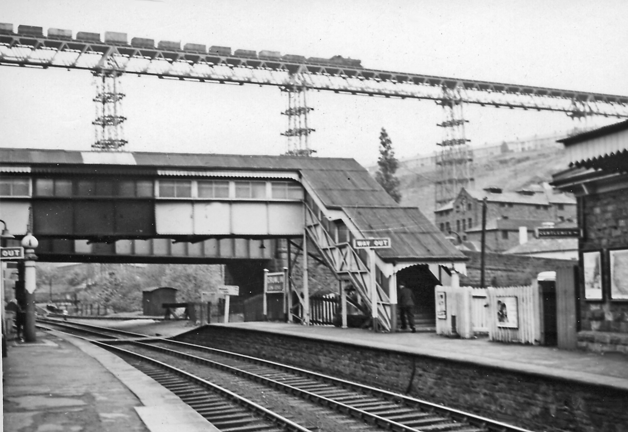
Newbridge. High up on the celebrated viaduct of the ex-GW Neath - Pontypool Road line, just east of Crumlin (High Level), is an eastbound coal train - looking very perilous. (See also 2986887).
361:– You must give appropriate credit, provide a link to the license, and indicate if changes were made. You may do so in any reasonable manner, but not in any way that suggests the licensor endorses you or your use.
610:
1035:
1030:
69:
42:
1173:
197:
869:
696:
596:
560:
243:
1072:
716:
441:
278:
1123:
This file contains additional information, probably added from the digital camera or scanner used to create or digitize it.
368:
523:
964:
927:
890:
835:
801:
739:
680:
651:
624:
544:
516:
503:
488:
862:
767:
724:
709:
580:
461:
425:
265:
324:
1126:
If the file has been modified from its original state, some details may not fully reflect the modified file.
367:– If you remix, transform, or build upon the material, you must distribute your contributions under the
285:
on the
Geograph website for the photographer's contact details. The copyright on this image is owned by
321:
617:"}},"text\/plain":{"en":{"P7787":"45 degree"}}}}": -->
118:
746:
731:
495:
1067:
249:
1090:
143:
Crumlin (Low Level) station and
Crumlin Viaduct geograph-2986824-by-Ben-Brooksbank.jpg
290:
105:
233:
1188:
1046:
186:
176:
270:
282:
1003:
Click on a date/time to view the file as it appeared at that time.
1100:
235:
220:
51° 40′ 37.13″ N, 3° 08′ 41.28″ W
210:
93:
409:
Add a one-line explanation of what this file represents
83:(2,106 × 1,450 pixels, file size: 1.26 MB, MIME type:
1110:
204:
Creative
Commons Attribution Share-alike license 2.0
137:
117:
Commons is a freely licensed media file repository.
597:
Creative
Commons Attribution-ShareAlike 2.0 Generic
154:Crumlin (Low Level) station and Crumlin Viaduct.
378:https://creativecommons.org/licenses/by-sa/2.0
98:
384:Creative Commons Attribution-Share Alike 2.0
302:
8:
614:
344:– to copy, distribute and transmit the work
1128:
1005:
405:
1091:Newport, Abergavenny and Hereford Railway
1083:The following other wikis use this file:
732:https://www.geograph.org.uk/photo/2986824
496:https://www.geograph.org.uk/profile/44502
851:98dc51209a710415b431f317e3e4a52631909e04
1228:
1220:
1212:
1204:
1196:
1186:
1178:
1168:
1160:
1152:
1144:
1135:
1130:
1065:
978:
962:
941:
925:
904:
888:
849:
833:
815:
799:
781:
765:
694:
678:
638:
622:
594:
578:
558:
542:
475:
459:
439:
423:
420:
401:
394:
213:
242:View this and other nearby images on:
1063:The following 2 pages use this file:
7:
1174:Adobe Photoshop Elements 3.0 Windows
289:and is licensed for reuse under the
994:
325:Attribution-Share Alike 2.0 Generic
313:
308:
293:Attribution-ShareAlike 2.0 license.
1121:
414:
408:
299:
276:
147:
130:
76:
413:
625:coordinates of the point of view
399:
355:Under the following conditions:
320:This file is licensed under the
312:
307:
301:
269:
248:
234:
226:
97:
31:
21:
1222:Date metadata was last modified
1073:Crumlin railway station (Wales)
396:
148:
14:
697:file available on the internet
395:
277:This image was taken from the
26:
1:
36:
717:Geograph Britain and Ireland
640:51°40'37.132"N, 3°8'41.284"W
517:object of statement has role
421:Items portrayed in this file
1214:Date and time of digitizing
225:
1250:
1107:Usage on www.wikidata.org
1097:Usage on es.wikipedia.org
1087:Usage on de.wikipedia.org
369:same or compatible license
1180:File change date and time
995:
167:Taken on 11 May 1957
16:
740:geograph.org.uk image ID
398:
335:
104:This is a file from the
1052:
192:
182:
171:
166:
163:
140:
108:. Information from its
283:this photograph's page
254:51.676981; -3.144801
111:description page there
46:Size of this preview:
1154:Horizontal resolution
863:determination method
70:2,106 × 1,450 pixels
1162:Vertical resolution
1138:EPSON scanner image
1101:Viaducto de Crumlin
1031:18:29, 13 June 2012
350:– to adapt the work
52:Other resolutions:
1225:23:21, 9 June 2012
1217:23:21, 9 June 2012
1183:23:21, 9 June 2012
504:author name string
66:1,280 × 881 pixels
62:1,024 × 705 pixels
1237:
1236:
1079:Global file usage
1056:
616:
581:copyright license
407:
298:
297:
281:collection. See
259:
258:
208:
207:
201:
198:Reusing this file
126:
125:
106:Wikimedia Commons
32:Global file usage
1241:
1139:
1129:
1043:
983:
946:
909:
872:
867:
749:
744:
734:
729:
725:described at URL
719:
714:
662:
661:
656:
545:copyright status
526:
521:
511:
508:
498:
493:
391:
388:
385:
382:
379:
371:as the original.
333:
322:Creative Commons
316:
315:
311:
310:
305:
304:
291:Creative Commons
279:Geograph project
273:
266:
255:
252:
238:
237:
231:
230:
229:
223:
222:
211:
195:
152:
144:
138:
122:
101:
100:
94:
88:
86:
73:
58:640 × 441 pixels
54:320 × 220 pixels
48:800 × 551 pixels
1249:
1248:
1244:
1243:
1242:
1240:
1239:
1238:
1137:
1117:
1077:
1068:Crumlin Viaduct
1057:
1049:
1041:
997:
996:
993:
992:
991:
990:
989:
988:
987:
986:
984:
981:
971:
970:
969:
967:
956:
955:
954:
953:
952:
951:
950:
949:
947:
944:
934:
933:
932:
930:
919:
918:
917:
916:
915:
914:
913:
912:
910:
907:
897:
896:
895:
893:
882:
881:
880:
879:
878:
877:
876:
875:
874:
873:
868:
865:
856:
855:
854:
852:
842:
841:
840:
838:
827:
826:
825:
824:
823:
822:
821:
820:
818:
808:
807:
806:
804:
793:
792:
791:
790:
789:
788:
787:
786:
784:
774:
773:
772:
770:
759:
758:
757:
756:
755:
754:
753:
752:
751:
750:
745:
742:
736:
735:
730:
727:
721:
720:
715:
712:
703:
702:
701:
699:
687:
686:
685:
683:
672:
671:
670:
669:
668:
667:
666:
665:
664:
663:
659:
657:
654:
645:
644:
643:
641:
631:
630:
629:
627:
608:
607:
606:
605:
604:
603:
602:
601:
599:
587:
586:
585:
583:
572:
571:
570:
569:
568:
567:
566:
565:
563:
551:
550:
549:
547:
536:
535:
534:
533:
532:
531:
530:
529:
528:
527:
522:
519:
513:
512:
509:
506:
500:
499:
494:
491:
482:
481:
480:
478:
468:
467:
466:
464:
453:
452:
451:
450:
449:
448:
447:
446:
444:
442:Crumlin Viaduct
432:
431:
430:
428:
412:
411:
410:
393:
392:
389:
386:
383:
380:
377:
376:
334:
331:
328:
317:
294:
264:
253:
227:
218:
217:
214:Camera location
209:
177:geograph.org.uk
159:
142:
135:
128:
127:
116:
115:
114:is shown below.
90:
84:
82:
75:
74:
51:
12:
11:
5:
1247:
1245:
1235:
1234:
1231:
1227:
1226:
1223:
1219:
1218:
1215:
1211:
1210:
1207:
1203:
1202:
1199:
1195:
1194:
1191:
1185:
1184:
1181:
1177:
1176:
1171:
1167:
1166:
1163:
1159:
1158:
1155:
1151:
1150:
1147:
1143:
1142:
1141:
1140:
1133:
1120:
1116:
1115:
1114:
1113:
1105:
1104:
1103:
1095:
1094:
1093:
1081:
1080:
1076:
1075:
1070:
1061:
1060:
1055:
1054:
1051:
1047:
1044:
1040:2,106 × 1,450
1038:
1033:
1028:
1024:
1023:
1020:
1017:
1014:
1011:
1008:
1001:
1000:
985:
979:
977:
976:
975:
974:
973:
972:
968:
963:
961:
960:
959:
958:
957:
948:
942:
940:
939:
938:
937:
936:
935:
931:
926:
924:
923:
922:
921:
920:
911:
905:
903:
902:
901:
900:
899:
898:
894:
889:
887:
886:
885:
884:
883:
861:
860:
859:
858:
857:
853:
850:
848:
847:
846:
845:
844:
843:
839:
834:
832:
831:
830:
829:
828:
819:
816:
814:
813:
812:
811:
810:
809:
805:
800:
798:
797:
796:
795:
794:
785:
782:
780:
779:
778:
777:
776:
775:
771:
766:
764:
763:
762:
761:
760:
738:
737:
723:
722:
708:
707:
706:
705:
704:
700:
695:
693:
692:
691:
690:
689:
688:
684:
681:source of file
679:
677:
676:
675:
674:
673:
650:
649:
648:
647:
646:
642:
639:
637:
636:
635:
634:
633:
632:
628:
623:
621:
620:
619:
618:
612:
600:
595:
593:
592:
591:
590:
589:
588:
584:
579:
577:
576:
575:
574:
573:
564:
559:
557:
556:
555:
554:
553:
552:
548:
543:
541:
540:
539:
538:
537:
515:
514:
510:Ben Brooksbank
502:
501:
487:
486:
485:
484:
483:
479:
476:
474:
473:
472:
471:
470:
469:
465:
460:
458:
457:
456:
455:
454:
445:
440:
438:
437:
436:
435:
434:
433:
429:
424:
422:
419:
418:
417:
416:
415:
404:
403:
400:
397:
375:
374:
373:
372:
362:
353:
352:
351:
345:
338:You are free:
332:Ben Brooksbank
329:
319:
318:
300:
296:
295:
287:Ben Brooksbank
274:
263:
260:
257:
256:
246:
240:
215:
206:
205:
202:
190:
189:
187:Ben Brooksbank
184:
180:
179:
173:
169:
168:
165:
161:
160:
145:
136:
134:
131:
129:
124:
123:
102:
92:
91:
45:
41:
40:
39:
34:
29:
24:
19:
13:
10:
9:
6:
4:
3:
2:
1246:
1232:
1229:
1224:
1221:
1216:
1213:
1208:
1205:
1200:
1197:
1192:
1190:
1187:
1182:
1179:
1175:
1172:
1170:Software used
1169:
1164:
1161:
1156:
1153:
1148:
1145:
1136:
1134:
1131:
1127:
1124:
1118:
1112:
1109:
1108:
1106:
1102:
1099:
1098:
1096:
1092:
1089:
1088:
1086:
1085:
1084:
1078:
1074:
1071:
1069:
1066:
1064:
1058:
1050:
1045:
1039:
1037:
1034:
1032:
1029:
1026:
1025:
1021:
1018:
1015:
1012:
1009:
1007:
1006:
1004:
998:
966:
929:
892:
871:
864:
837:
803:
769:
748:
741:
733:
726:
718:
711:
698:
682:
653:
626:
598:
582:
562:
546:
525:
518:
505:
497:
490:
463:
443:
427:
381:CC BY-SA 2.0
370:
366:
363:
360:
357:
356:
354:
349:
346:
343:
340:
339:
337:
336:
330:Attribution:
326:
323:
306:
292:
288:
284:
280:
275:
272:
268:
267:
261:
251:
247:
245:
244:OpenStreetMap
241:
239:
221:
216:
212:
203:
199:
194:
191:
188:
185:
181:
178:
174:
170:
162:
156:
155:
151:
146:
139:
132:
120:
113:
112:
107:
103:
96:
95:
89:
80:
79:Original file
71:
67:
63:
59:
55:
49:
44:
38:
35:
33:
30:
28:
25:
23:
20:
18:
15:
1206:Image height
1193:Uncalibrated
1125:
1122:
1082:
1062:
1002:
999:File history
524:photographer
364:
358:
347:
341:
286:
224:
153:
149:
119:You can help
109:
77:
22:File history
1230:IIM version
1198:Image width
1189:Color space
1146:Orientation
1132:Image title
783:11 May 1957
561:copyrighted
365:share alike
359:attribution
141:Description
1059:File usage
1016:Dimensions
906:1,316,274
817:image/jpeg
802:media type
477:some value
193:Permission
85:image/jpeg
27:File usage
1042:(1.26 MB)
1013:Thumbnail
1010:Date/Time
891:data size
768:inception
262:Licensing
150:English:
1209:1,450 px
1201:2,106 px
1119:Metadata
1111:Q5190053
836:checksum
710:operator
402:Captions
348:to remix
342:to share
327:license.
37:Metadata
1165:157 dpc
1157:157 dpc
1027:current
1022:Comment
747:2986824
652:heading
611:heading
462:creator
426:depicts
406:English
133:Summary
81:
1149:Normal
1048:Chevin
980:2,106
943:1,450
928:height
660:degree
615:degree
232:
183:Author
172:Source
982:pixel
965:width
945:pixel
870:SHA-1
175:From
1019:User
908:byte
390:true
387:true
164:Date
17:File
658:45
489:URL
866::
743::
728::
713::
655::
520::
507::
492::
68:|
64:|
60:|
56:|
50:.
1233:2
200:)
196:(
121:.
87:)
72:.
Text is available under the Creative Commons Attribution-ShareAlike License. Additional terms may apply.
_station_and_Crumlin_Viaduct_geograph-2986824-by-Ben-Brooksbank.jpg)
_station_and_Crumlin_Viaduct_geograph-2986824-by-Ben-Brooksbank.jpg¶ms=051.676981_N_-003.144801_E_globe:Earth_type:camera_heading:45.00&language=en)
