38:
496:
312:
502:
230:
507:
466:
447:
94:
426:
1003:
1033:
973:
548:– You must give appropriate credit, provide a link to the license, and indicate if changes were made. You may do so in any reasonable manner, but not in any way that suggests the licensor endorses you or your use.
437:
354:
277:
322:
245:
68:
64:
60:
56:
52:
48:
42:
105:
77:
806:
718:
682:
646:
1075:
This file contains additional information, probably added from the digital camera or scanner used to create or digitize it.
555:
1032:
1027:
1002:
997:
901:
864:
827:
772:
738:
702:
630:
799:
666:
613:
517:
1078:
If the file has been modified from its original state, some details may not fully reflect the modified file.
1060:
The following pages on the
English Knowledge (XXG) use this file (pages on other projects are not listed):
554:– If you remix, transform, or build upon the material, you must distribute your contributions under the
1020:
Removed shore casings, enlarged nominal size, removed smallest islands, included nearby shore in scope.
514:
113:
972:
967:
37:
1043:
1013:
983:
1064:
100:
489:
I, the copyright holder of this work, hereby publish it under the following license:
393:
194:
159:
369:
356:
337:
324:
292:
279:
260:
247:
210:
457:
311:
473:
990:
Enlarged labels for legibility, simplified scale, removed north arrow.
432:
132:
940:
Click on a date/time to view the file as it appeared at that time.
229:
465:
446:
453:
88:
149:
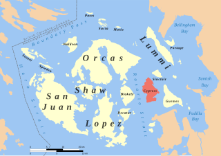
Cypress Island highlighted in red among the San Juan
Islands.
425:
82:(SVG file, nominally 1,052 × 744 pixels, file size: 232 KB)
683:
Creative
Commons Attribution-ShareAlike 4.0 International
597:
Add a one-line explanation of what this file represents
402:
If inappropriate please set warp_status = skip to hide.
112:
Commons is a freely licensed media file repository.
177:Shorelines: Western Washington University; USGS
565:https://creativecommons.org/licenses/by-sa/4.0
93:
571:Creative Commons Attribution-Share Alike 4.0
495:
8:
531:– to copy, distribute and transmit the work
41:Size of this PNG preview of this SVG file:
1080:
942:
593:
518:Attribution-Share Alike 4.0 International
788:e3a20948200fdc37a77ea6e4a90fa68ceb0a84be
1098:
1090:
1082:
1062:
915:
899:
878:
862:
841:
825:
786:
770:
752:
736:
716:
700:
680:
664:
644:
628:
611:
608:
589:
582:
396:Georeference the map in Wikimaps Warper
180:Land and marine feature labels: US GNIS
7:
1050:User created page with UploadWizard
931:
506:
501:
1073:
602:
596:
492:
488:
470:
451:
430:
143:
125:
75:
601:
587:
542:Under the following conditions:
513:This file is licensed under the
505:
500:
494:
464:
445:
424:
310:
228:
92:
21:
584:
370:48.3941795318°N 122.418770668°W
293:48.8192294831°N 122.413872293°W
144:
14:
583:
338:48.395198424°N 123.321508159°W
261:48.820263626°N 123.324217836°W
138:Cypress Island locator map.svg
26:
1:
719:original creation by uploader
394:
375:48.3941795318; -122.418770668
298:48.8192294831; -122.413872293
31:
609:Items portrayed in this file
343:48.395198424; -123.321508159
266:48.820263626; -123.324217836
1120:
556:same or compatible license
240:
932:
407:
220:UTM zone 10N, NAD83 datum
201:
171:
16:
998:21:48, 14 September 2015
586:
522:
408: Bibliographic data
217:Spatial reference system
99:This is a file from the
1049:
1028:01:12, 2 September 2015
1019:
989:
412:
388:
236:
224:
216:
206:
189:
165:
155:
135:
103:. Information from its
968:18:56, 25 October 2015
202: Geotemporal data
106:description page there
183:National border: USGS
800:determination method
65:2,560 × 1,810 pixels
537:– to adapt the work
47:Other resolutions:
69:1,052 × 744 pixels
61:1,280 × 905 pixels
57:1,024 × 724 pixels
1107:
1106:
1053:
667:copyright license
595:
456:was created with
420:
419:
403:
384:
383:
121:
120:
101:Wikimedia Commons
1111:
1087:San Juan Locator
1081:
1040:
1010:
980:
920:
883:
846:
809:
804:
631:copyright status
578:
575:
572:
569:
566:
558:as the original.
515:Creative Commons
509:
508:
504:
503:
498:
497:
476:
468:
449:
440:
428:
401:
400:
398:
397:
380:
378:
377:
376:
371:
367:
366:
363:
362:
359:
348:
346:
345:
344:
339:
335:
334:
331:
330:
327:
314:
303:
301:
300:
299:
294:
290:
289:
286:
285:
282:
271:
269:
268:
267:
262:
258:
257:
254:
253:
250:
241:
232:
212:
173:
161:
160:1 September 2015
148:
139:
133:
117:
96:
95:
89:
83:
72:
53:640 × 453 pixels
49:320 × 226 pixels
43:800 × 566 pixels
1119:
1118:
1114:
1113:
1112:
1110:
1109:
1108:
1069:
1061:
1054:
1046:
1038:
1016:
1008:
986:
978:
934:
933:
930:
929:
928:
927:
926:
925:
924:
923:
921:
918:
908:
907:
906:
904:
893:
892:
891:
890:
889:
888:
887:
886:
884:
881:
871:
870:
869:
867:
856:
855:
854:
853:
852:
851:
850:
849:
847:
844:
834:
833:
832:
830:
819:
818:
817:
816:
815:
814:
813:
812:
811:
810:
805:
802:
793:
792:
791:
789:
779:
778:
777:
775:
764:
763:
762:
761:
760:
759:
758:
757:
755:
745:
744:
743:
741:
730:
729:
728:
727:
726:
725:
724:
723:
721:
709:
708:
707:
705:
694:
693:
692:
691:
690:
689:
688:
687:
685:
673:
672:
671:
669:
658:
657:
656:
655:
654:
653:
652:
651:
649:
637:
636:
635:
633:
622:
621:
620:
619:
618:
616:
600:
599:
598:
581:
580:
579:
576:
573:
570:
567:
564:
563:
521:
510:
491:
490:
485:
480:
479:
478:
472:
462:
461:
443:
442:
436:
421:
395:
392:
374:
372:
368:
364:
360:
357:
355:
353:
342:
340:
336:
332:
328:
325:
323:
321:
297:
295:
291:
287:
283:
280:
278:
276:
265:
263:
259:
255:
251:
248:
246:
244:
197:
151:
150:
137:
130:
123:
122:
111:
110:
109:is shown below.
85:
81:
74:
73:
46:
12:
11:
5:
1117:
1115:
1105:
1104:
1101:
1097:
1096:
1093:
1089:
1088:
1085:
1072:
1068:
1067:
1065:Cypress Island
1059:
1058:
1057:
1052:
1051:
1048:
1044:
1041:
1035:
1030:
1025:
1022:
1021:
1018:
1014:
1011:
1005:
1000:
995:
992:
991:
988:
984:
981:
975:
970:
965:
961:
960:
957:
954:
951:
948:
945:
938:
937:
922:
916:
914:
913:
912:
911:
910:
909:
905:
900:
898:
897:
896:
895:
894:
885:
879:
877:
876:
875:
874:
873:
872:
868:
863:
861:
860:
859:
858:
857:
848:
842:
840:
839:
838:
837:
836:
835:
831:
826:
824:
823:
822:
821:
820:
798:
797:
796:
795:
794:
790:
787:
785:
784:
783:
782:
781:
780:
776:
771:
769:
768:
767:
766:
765:
756:
753:
751:
750:
749:
748:
747:
746:
742:
737:
735:
734:
733:
732:
731:
722:
717:
715:
714:
713:
712:
711:
710:
706:
703:source of file
701:
699:
698:
697:
696:
695:
686:
681:
679:
678:
677:
676:
675:
674:
670:
665:
663:
662:
661:
660:
659:
650:
645:
643:
642:
641:
640:
639:
638:
634:
629:
627:
626:
625:
624:
623:
617:
612:
610:
607:
606:
605:
604:
603:
592:
591:
588:
585:
562:
561:
560:
559:
549:
540:
539:
538:
532:
525:You are free:
512:
511:
493:
487:
486:
484:
481:
463:
444:
423:
422:
418:
417:
414:
410:
409:
405:
404:
390:
389:Georeferencing
386:
385:
382:
381:
351:
349:
318:
317:
315:
308:
305:
304:
274:
272:
238:
234:
233:
226:
222:
221:
218:
214:
213:
211:September 2015
208:
204:
203:
199:
198:
195:Evan Derickson
193:
191:
187:
186:
185:
184:
181:
178:
167:
163:
162:
157:
153:
152:
142:
140:
131:
129:
126:
124:
119:
118:
97:
87:
86:
40:
36:
35:
34:
29:
24:
19:
13:
10:
9:
6:
4:
3:
2:
1116:
1102:
1099:
1094:
1091:
1086:
1083:
1079:
1076:
1070:
1066:
1063:
1055:
1047:
1042:
1036:
1034:
1031:
1029:
1026:
1024:
1023:
1017:
1012:
1006:
1004:
1001:
999:
996:
994:
993:
987:
982:
976:
974:
971:
969:
966:
963:
962:
958:
955:
952:
949:
946:
944:
943:
941:
935:
903:
866:
829:
808:
801:
774:
754:image/svg+xml
740:
720:
704:
684:
668:
648:
632:
615:
568:CC BY-SA 4.0
557:
553:
550:
547:
544:
543:
541:
536:
533:
530:
527:
526:
524:
523:
519:
516:
499:
482:
475:
467:
459:
455:
448:
439:
434:
427:
415:
411:
406:
399:
391:
387:
379:
352:
350:
347:
320:
319:
316:
313:
309:
307:
306:
302:
275:
273:
270:
243:
242:
239:
235:
231:
227:
223:
219:
215:
209:
207:Date depicted
205:
200:
196:
192:
188:
182:
179:
176:
175:
174:
170:Cartography:
168:
164:
158:
154:
147:
141:
134:
127:
115:
108:
107:
102:
98:
91:
90:
84:
79:
78:Original file
70:
66:
62:
58:
54:
50:
44:
39:
33:
30:
28:
25:
23:
20:
18:
15:
1077:
1074:
1007:1,052 × 744
977:1,052 × 744
939:
936:File history
551:
545:
534:
528:
237:Bounding box
169:
145:
114:You can help
104:
76:
22:File history
1084:Short title
647:copyrighted
552:share alike
546:attribution
361:122°25′08″W
329:123°19′17″W
284:122°24′50″W
252:123°19′27″W
136:Description
1056:File usage
1045:Hotshot977
1037:562 × 405
1015:Hotshot977
985:Hotshot977
953:Dimensions
739:media type
358:48°23′39″N
326:48°23′43″N
281:48°49′09″N
249:48°49′13″N
27:File usage
950:Thumbnail
947:Date/Time
828:data size
483:Licensing
471:and with
146:English:
1071:Metadata
1039:(987 KB)
1009:(233 KB)
979:(232 KB)
843:237,757
773:checksum
590:Captions
535:to remix
529:to share
520:license.
458:Inkscape
435:code is
413:Language
172:Own work
32:Metadata
1095:296.9mm
964:current
959:Comment
614:depicts
594:English
416:English
225:Heading
190:Creator
128:Summary
80:
1100:Height
917:1,052
865:height
469:
452:This
450:
429:
166:Source
1103:210mm
1092:Width
919:pixel
902:width
882:pixel
807:SHA-1
438:valid
956:User
880:744
845:byte
577:true
574:true
474:QGIS
431:The
156:Date
17:File
454:map
433:SVG
365:/
333:/
288:/
256:/
803::
373:/
341:/
296:/
264:/
67:|
63:|
59:|
55:|
51:|
45:.
477:.
460:.
441:.
116:.
71:.
Text is available under the Creative Commons Attribution-ShareAlike License. Additional terms may apply.


