43:
251:
212:
226:
257:
262:
103:
1021:
203:
303:– You must give appropriate credit, provide a link to the license, and indicate if changes were made. You may do so in any reasonable manner, but not in any way that suggests the licensor endorses you or your use.
69:
65:
61:
57:
53:
47:
114:
82:
712:
624:
520:
484:
219:
1020:
1015:
73:
42:
1294:
1133:
This file contains additional information, probably added from the digital camera or scanner used to create or digitize it.
310:
949:
915:
878:
844:
807:
770:
733:
678:
644:
608:
574:
468:
442:
427:
412:
705:
540:
504:
385:
368:
157:
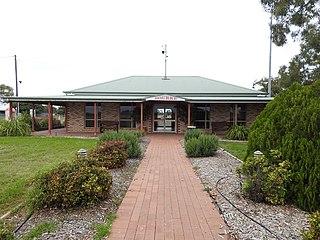
Photograph of front of Bourke
Airport building. North Bourke, Bourke region, New South Wales, Australia (Apr 2021).
272:
1136:
If the file has been modified from its original state, some details may not fully reflect the modified file.
434:
1048:
The following pages on the
English Knowledge (XXG) use this file (pages on other projects are not listed):
1342:
309:– If you remix, transform, or build upon the material, you must distribute your contributions under the
1263:
269:
1378:
352:
Airport reception building front, North Bourke, Bourke region, New South Wales, Australia (2021).
122:
1483:
419:
166:
1052:
225:
1438:
1360:
1162:
109:
244:
I, the copyright holder of this work, hereby publish it under the following license:
1493:
1448:
1202:
1155:
209:
1396:
1182:
1031:
1503:
1172:
186:
1080:
988:
Click on a date/time to view the file as it appeared at that time.
567:
1145:
204:
30° 02′ 29.92″ S, 145° 56′ 59.02″ E
1090:
211:
1100:
194:
97:
147:
AU-NSW-North Bourke-Airport reception building front-2021.jpg
1070:
1110:
521:
Creative
Commons Attribution-ShareAlike 4.0 International
87:(3,264 × 2,448 pixels, file size: 1.62 MB, MIME type:
141:
121:
Commons is a freely licensed media file repository.
1120:
1383:Flash did not fire, compulsory flash suppression
320:https://creativecommons.org/licenses/by-sa/4.0
102:
326:Creative Commons Attribution-Share Alike 4.0
250:
8:
286:– to copy, distribute and transmit the work
1138:
990:
348:
1063:The following other wikis use this file:
273:Attribution-Share Alike 4.0 International
694:80f95b0484a71e77d659b3b6def3980e8c9ea202
420:https://commons.wikimedia.org/user:Q8682
1551:
1543:
1535:
1527:
1519:
1511:
1501:
1491:
1481:
1473:
1465:
1457:
1446:
1436:
1428:
1420:
1412:
1404:
1394:
1386:
1376:
1368:
1358:
1350:
1340:
1332:
1311:
1303:
1292:
1284:
1276:
1268:
1258:
1250:
1242:
1234:
1226:
1218:
1210:
1199:
1191:
1180:
1170:
1160:
1150:
1050:
963:
947:
929:
913:
892:
876:
858:
842:
821:
805:
784:
768:
747:
731:
692:
676:
658:
642:
622:
606:
588:
572:
554:
538:
518:
502:
482:
466:
399:
383:
366:
363:
344:
337:
197:
218:View this and other nearby images on:
1140:
7:
1038:Uploaded own work with UploadWizard
979:
261:
256:
1131:
357:
351:
247:
243:
151:
134:
80:
356:
1193:Date and time of data generation
575:coordinates of the point of view
342:
297:Under the following conditions:
268:This file is licensed under the
260:
255:
249:
224:
210:
101:
31:
21:
1529:Satellites used for measurement
339:
152:
14:
590:30°2'29.922"S, 145°56'59.017"E
338:
26:
1:
1417:A directly photographed image
625:original creation by uploader
36:
1231:107.6 meters above sea level
364:Items portrayed in this file
1305:Date and time of digitizing
1067:Usage on ceb.wikipedia.org
1573:
1459:Focal length in 35 mm film
1388:Supported Flashpix version
1117:Usage on www.wikidata.org
1107:Usage on sv.wikipedia.org
1097:Usage on ro.wikipedia.org
1087:Usage on id.wikipedia.org
1077:Usage on fr.wikipedia.org
311:same or compatible license
1537:Geodetic survey data used
1313:Meaning of each component
1270:File change date and time
980:
176:
16:
341:
277:
108:This is a file from the
1521:GPS time (atomic clock)
1422:Custom image processing
1037:
230:-30.041645; 145.949727
182:
172:
167:16 April 2021, 09:35:12
165:
162:
144:
112:. Information from its
1513:Subject distance range
1334:Image compression mode
115:description page there
46:Size of this preview:
1352:Maximum land aperture
1244:Horizontal resolution
1409:Digital still camera
1308:09:35, 16 April 2021
1273:09:35, 16 April 2021
1196:09:35, 16 April 2021
1016:14:40, 26 April 2021
706:determination method
74:3,264 × 2,448 pixels
70:2,560 × 1,920 pixels
1278:Y and C positioning
1264:COOLPIX P900 V1.5
1252:Vertical resolution
1142:Camera manufacturer
1091:Bandar Udara Bourke
292:– to adapt the work
52:Other resolutions:
1467:Scene capture type
1443:Auto white balance
1167:1/400 sec (0.0025)
1081:Aéroport de Bourke
443:author name string
428:Wikimedia username
66:1,280 × 960 pixels
62:1,024 × 768 pixels
1560:
1559:
1355:2.9 APEX (f/2.73)
1223:145° 56′ 59.02″ E
1101:Aeroportul Bourke
1059:Global file usage
1041:
505:copyright license
350:
235:
234:
192:
191:
130:
129:
110:Wikimedia Commons
32:Global file usage
1564:
1286:Exposure Program
1139:
1028:
968:
897:
826:
789:
752:
715:
710:
469:copyright status
450:
447:
437:
432:
422:
417:
333:
330:
327:
324:
321:
313:as the original.
270:Creative Commons
264:
263:
259:
258:
253:
252:
231:
228:
214:
213:
207:
206:
195:
178:
168:
156:
148:
142:
126:
105:
104:
98:
92:
90:
77:
58:640 × 480 pixels
54:320 × 240 pixels
48:800 × 600 pixels
1572:
1571:
1567:
1566:
1565:
1563:
1562:
1561:
1553:GPS tag version
1215:30° 2′ 29.92″ S
1127:
1057:
1049:
1042:
1034:
1026:
982:
981:
978:
977:
976:
975:
974:
973:
972:
971:
969:
966:
956:
955:
954:
952:
941:
940:
939:
938:
937:
936:
935:
934:
932:
922:
921:
920:
918:
907:
906:
905:
904:
903:
902:
901:
900:
898:
895:
885:
884:
883:
881:
870:
869:
868:
867:
866:
865:
864:
863:
861:
851:
850:
849:
847:
836:
835:
834:
833:
832:
831:
830:
829:
827:
824:
814:
813:
812:
810:
799:
798:
797:
796:
795:
794:
793:
792:
790:
787:
777:
776:
775:
773:
762:
761:
760:
759:
758:
757:
756:
755:
753:
750:
740:
739:
738:
736:
725:
724:
723:
722:
721:
720:
719:
718:
717:
716:
711:
708:
699:
698:
697:
695:
685:
684:
683:
681:
670:
669:
668:
667:
666:
665:
664:
663:
661:
651:
650:
649:
647:
636:
635:
634:
633:
632:
631:
630:
629:
627:
615:
614:
613:
611:
600:
599:
598:
597:
596:
595:
594:
593:
591:
581:
580:
579:
577:
566:
565:
564:
563:
562:
561:
560:
559:
557:
547:
546:
545:
543:
532:
531:
530:
529:
528:
527:
526:
525:
523:
511:
510:
509:
507:
496:
495:
494:
493:
492:
491:
490:
489:
487:
475:
474:
473:
471:
460:
459:
458:
457:
456:
455:
454:
453:
452:
451:
448:
445:
439:
438:
433:
430:
424:
423:
418:
415:
406:
405:
404:
402:
392:
391:
390:
388:
377:
376:
375:
374:
373:
371:
355:
354:
353:
336:
335:
334:
331:
328:
325:
322:
319:
318:
276:
265:
246:
245:
240:
229:
202:
201:
198:Camera location
193:
158:
146:
139:
132:
131:
120:
119:
118:is shown below.
94:
88:
86:
79:
78:
51:
12:
11:
5:
1570:
1568:
1558:
1557:
1554:
1550:
1549:
1546:
1542:
1541:
1538:
1534:
1533:
1530:
1526:
1525:
1522:
1518:
1517:
1514:
1510:
1509:
1506:
1500:
1499:
1496:
1490:
1489:
1486:
1480:
1479:
1478:High gain down
1476:
1472:
1471:
1468:
1464:
1463:
1460:
1456:
1455:
1452:
1445:
1444:
1441:
1435:
1434:
1431:
1427:
1426:
1425:Normal process
1423:
1419:
1418:
1415:
1411:
1410:
1407:
1403:
1402:
1399:
1393:
1392:
1389:
1385:
1384:
1381:
1375:
1374:
1371:
1367:
1366:
1363:
1357:
1356:
1353:
1349:
1348:
1345:
1339:
1338:
1335:
1331:
1330:
1329:
1328:
1327:does not exist
1325:
1322:
1319:
1314:
1310:
1309:
1306:
1302:
1301:
1298:
1291:
1290:
1289:Normal program
1287:
1283:
1282:
1279:
1275:
1274:
1271:
1267:
1266:
1261:
1257:
1256:
1253:
1249:
1248:
1245:
1241:
1240:
1237:
1233:
1232:
1229:
1225:
1224:
1221:
1217:
1216:
1213:
1209:
1208:
1205:
1198:
1197:
1194:
1190:
1189:
1186:
1179:
1178:
1175:
1169:
1168:
1165:
1159:
1158:
1153:
1149:
1148:
1143:
1130:
1126:
1125:
1124:
1123:
1115:
1114:
1113:
1111:Bourke Airport
1105:
1104:
1103:
1095:
1094:
1093:
1085:
1084:
1083:
1075:
1074:
1073:
1071:Bourke Airport
1061:
1060:
1056:
1055:
1053:Bourke Airport
1047:
1046:
1045:
1040:
1039:
1036:
1032:
1029:
1025:3,264 × 2,448
1023:
1018:
1013:
1009:
1008:
1005:
1002:
999:
996:
993:
986:
985:
970:
964:
962:
961:
960:
959:
958:
957:
953:
948:
946:
945:
944:
943:
942:
933:
930:
928:
927:
926:
925:
924:
923:
919:
914:
912:
911:
910:
909:
908:
899:
893:
891:
890:
889:
888:
887:
886:
882:
877:
875:
874:
873:
872:
871:
862:
859:
857:
856:
855:
854:
853:
852:
848:
843:
841:
840:
839:
838:
837:
828:
822:
820:
819:
818:
817:
816:
815:
811:
806:
804:
803:
802:
801:
800:
791:
785:
783:
782:
781:
780:
779:
778:
774:
769:
767:
766:
765:
764:
763:
754:
748:
746:
745:
744:
743:
742:
741:
737:
732:
730:
729:
728:
727:
726:
704:
703:
702:
701:
700:
696:
693:
691:
690:
689:
688:
687:
686:
682:
677:
675:
674:
673:
672:
671:
662:
659:
657:
656:
655:
654:
653:
652:
648:
643:
641:
640:
639:
638:
637:
628:
623:
621:
620:
619:
618:
617:
616:
612:
609:source of file
607:
605:
604:
603:
602:
601:
592:
589:
587:
586:
585:
584:
583:
582:
578:
573:
571:
570:
569:
568:
558:
555:
553:
552:
551:
550:
549:
548:
544:
539:
537:
536:
535:
534:
533:
524:
519:
517:
516:
515:
514:
513:
512:
508:
503:
501:
500:
499:
498:
497:
488:
483:
481:
480:
479:
478:
477:
476:
472:
467:
465:
464:
463:
462:
461:
441:
440:
426:
425:
411:
410:
409:
408:
407:
403:
400:
398:
397:
396:
395:
394:
393:
389:
384:
382:
381:
380:
379:
378:
372:
367:
365:
362:
361:
360:
359:
358:
347:
346:
343:
340:
317:
316:
315:
314:
304:
295:
294:
293:
287:
280:You are free:
267:
266:
248:
242:
241:
239:
236:
233:
232:
222:
216:
199:
190:
189:
184:
180:
179:
174:
170:
169:
164:
160:
159:
149:
140:
138:
135:
133:
128:
127:
106:
96:
95:
45:
41:
40:
39:
34:
29:
24:
19:
13:
10:
9:
6:
4:
3:
2:
1569:
1555:
1552:
1548:15 April 2021
1547:
1544:
1539:
1536:
1531:
1528:
1523:
1520:
1515:
1512:
1507:
1505:
1502:
1497:
1495:
1492:
1487:
1485:
1482:
1477:
1475:Scene control
1474:
1469:
1466:
1461:
1458:
1453:
1450:
1447:
1442:
1440:
1439:White balance
1437:
1433:Auto exposure
1432:
1430:Exposure mode
1429:
1424:
1421:
1416:
1413:
1408:
1405:
1400:
1398:
1395:
1390:
1387:
1382:
1380:
1377:
1372:
1369:
1364:
1362:
1361:Metering mode
1359:
1354:
1351:
1346:
1344:
1343:Exposure bias
1341:
1336:
1333:
1326:
1323:
1320:
1317:
1316:
1315:
1312:
1307:
1304:
1299:
1296:
1293:
1288:
1285:
1280:
1277:
1272:
1269:
1265:
1262:
1260:Software used
1259:
1254:
1251:
1246:
1243:
1238:
1235:
1230:
1227:
1222:
1219:
1214:
1211:
1206:
1204:
1200:
1195:
1192:
1187:
1184:
1181:
1176:
1174:
1171:
1166:
1164:
1163:Exposure time
1161:
1157:
1154:
1151:
1147:
1144:
1141:
1137:
1134:
1128:
1122:
1119:
1118:
1116:
1112:
1109:
1108:
1106:
1102:
1099:
1098:
1096:
1092:
1089:
1088:
1086:
1082:
1079:
1078:
1076:
1072:
1069:
1068:
1066:
1065:
1064:
1058:
1054:
1051:
1043:
1035:
1030:
1024:
1022:
1019:
1017:
1014:
1011:
1010:
1006:
1003:
1000:
997:
994:
992:
991:
989:
983:
951:
917:
880:
879:exposure time
846:
809:
772:
735:
714:
707:
680:
646:
626:
610:
576:
556:16 April 2021
542:
522:
506:
486:
470:
444:
436:
429:
421:
414:
387:
370:
323:CC BY-SA 4.0
312:
308:
305:
302:
299:
298:
296:
291:
288:
285:
282:
281:
279:
278:
274:
271:
254:
237:
227:
223:
221:
220:OpenStreetMap
217:
215:
205:
200:
196:
188:
185:
181:
175:
171:
161:
155:
150:
143:
136:
124:
117:
116:
111:
107:
100:
99:
93:
84:
83:Original file
75:
71:
67:
63:
59:
55:
49:
44:
38:
35:
33:
30:
28:
25:
23:
20:
18:
15:
1449:Digital zoom
1370:Light source
1203:focal length
1156:COOLPIX P900
1152:Camera model
1135:
1132:
1062:
987:
984:File history
950:focal length
306:
300:
289:
283:
153:
123:You can help
113:
81:
22:File history
1406:File source
1397:Color space
1236:Orientation
485:copyrighted
307:share alike
301:attribution
145:Description
1494:Saturation
1414:Scene type
1044:File usage
1001:Dimensions
967:millimetre
749:1,695,010
660:image/jpeg
645:media type
401:some value
89:image/jpeg
27:File usage
1504:Sharpness
1220:Longitude
1183:ISO speed
1027:(1.62 MB)
998:Thumbnail
995:Date/Time
845:ISO speed
734:data size
541:inception
238:Licensing
154:English:
1545:GPS date
1484:Contrast
1470:Standard
1281:Centered
1228:Altitude
1212:Latitude
1173:F-number
1129:Metadata
916:f-number
679:checksum
345:Captions
290:to remix
284:to share
275:license.
177:Own work
37:Metadata
1556:0.0.3.2
1516:Unknown
1373:Unknown
1365:Pattern
1297:version
1255:300 dpi
1247:300 dpi
1012:current
1007:Comment
894:0.0025
386:creator
369:depicts
349:English
137:Summary
85:
1508:Normal
1498:Normal
1488:Normal
1239:Normal
1207:4.3 mm
1185:rating
1121:Q17526
896:second
823:3,264
786:2,448
771:height
208:
183:Author
173:Source
1540:WGS84
1524:23:30
1462:24 mm
1451:ratio
1379:Flash
1201:Lens
1177:f/2.8
1146:NIKON
1033:Q8682
825:pixel
808:width
788:pixel
713:SHA-1
449:Q8682
435:Q8682
187:Q8682
1401:sRGB
1295:Exif
1004:User
965:4.3
751:byte
332:true
329:true
163:Date
17:File
1532:13
1300:2.3
1188:100
931:2.8
860:100
413:URL
1324:Cr
1321:Cb
709::
446::
431::
416::
72:|
68:|
64:|
60:|
56:|
50:.
1454:0
1391:1
1347:1
1337:2
1318:Y
125:.
91:)
76:.
Text is available under the Creative Commons Attribution-ShareAlike License. Additional terms may apply.
