592:
38:
532:
604:
792:
568:
556:
520:
508:
496:
580:
544:
484:
675:
144:
630:
158:
681:
686:
94:
1438:
1408:
1378:
744:– You must give appropriate credit, provide a link to the license, and indicate if changes were made. You may do so in any reasonable manner, but not in any way that suggests the licensor endorses you or your use.
135:
856:{{Location|42|33|00|N|01|36|00|E|scale:200000}} {{Information |Description={{en|Topographic map in French of ]}}{{fr|Carte topographique en français de l']}} |Source={
802:
647:
68:
64:
60:
56:
52:
48:
42:
105:
645:; with no Invariant Sections, no Front-Cover Texts, and no Back-Cover Texts. A copy of the license is included in the section entitled
77:
637:
806:
1211:
1055:
1038:
1021:
1004:
987:
970:
934:
151:
824:
751:
455:
360:
299:
238:
1437:
1432:
1407:
1402:
1306:
1269:
1232:
1177:
1143:
1109:
918:
642:
1204:
1075:
954:
901:
791:
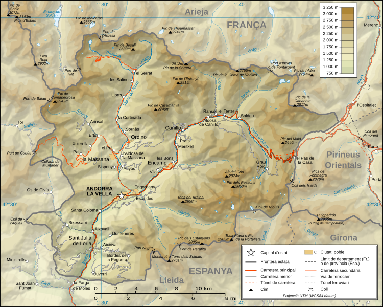
382: ; projection UTM ; WGS84 datum ; relief ombré (image composite d'éclairages du N-O, O et N) ;
713:
709:
705:
701:
697:
405:Échelle approximative des données topographiques : 1:400 000 (précision : environ 100 m) ;
591:
531:
1477:
The following pages on the
English Knowledge (XXG) use this file (pages on other projects are not listed):
750:– If you remix, transform, or build upon the material, you must distribute your contributions under the
603:
449:
693:
260:; projecció UTM; WGS84 datum; relleu ombrejat (imatge composta de posicions lluminoses de NO, O i N).
321:; UTM projection; WGS84 datum; shaded relief (composite image of N-W, W and N lightning positions);
567:
113:
1377:
1372:
555:
37:
519:
507:
495:
624:
579:
543:
483:
865:
635:
Permission is granted to copy, distribute and/or modify this document under the terms of the
463:
1534:
157:
1425:{{Information |Description= |Source= |Date= |Author= |Permission= |other_versions= }}
621:
I, the copyright holder of this work, hereby publish it under the following licenses:
220:
100:
1604:
371:
310:
249:
1481:
1624:
283:
Escala aproximada de les dades topogràfiques: 1:400.000 (precisió: uns 100 m);
1544:
375:
314:
253:
1519:
318:
257:
1564:
198:
1448:
1418:
1388:
851:
841:
831:
459:
379:
344:
Approximate scale of topographic data: 1:400,000 (accuracy: about 100 m);
1464:
1460:
1456:
209:
141:
801:
into your language, using any capable SVG editor, text editor or the
445:
289:
El relleu ombrejat és una imatge rastrejada immersa en el fitxer SVG.
786:
396:
335:
274:
1345:
Click on a date/time to view the file as it appeared at that time.
186:
1539:
367:
306:
245:
143:
1102:
1524:
1395:
topònim actualitzats amb el nomenclàtor d'Andorra de 2010
126:
88:
82:(SVG file, nominally 1,625 × 1,300 pixels, file size: 1.58 MB)
385:
Références utilisées pour les données complémentaires :
350:
The shaded relief is a raster image embedded in the SVG file.
1634:
269:
lloc web del
Ministeri d'Urbanisme i Ordenament Territorial
1574:
330:
site of the
Ministeri d'Urbanisme i Ordenament Territorial
1614:
988:
Creative
Commons Attribution-ShareAlike 4.0 International
820:
This image is a derivative work of the following images:
136:
42° 33′ 00″ N, 1° 36′ 00″ E
1654:
1594:
1584:
1459:
en versió en català}}{{en|Topographic map in
Catalan of
1455:{{Information |Description={{ca|Mapa topogràfic d'
885:
Add a one-line explanation of what this file represents
391:
site du
Ministeri d'Urbanisme i Ordenament Territorial
419:
Approximate geographic limits of the map (3" close):
390:
329:
268:
1674:
1669:
1554:
1529:
1509:
1499:
1056:
Creative
Commons Attribution-ShareAlike 3.0 Unported
1022:
641:, Version 1.2 or any later version published by the
169:
112:
Commons is a freely licensed media file repository.
1644:
1039:
Creative
Commons Attribution-ShareAlike 1.0 Generic
1005:
Creative
Commons Attribution-ShareAlike 2.0 Generic
971:
Creative Commons Attribution-ShareAlike 2.5 Generic
1664:
1463:}}{{fr|Carte topographique en catalan de l'
761:https://creativecommons.org/licenses/by-sa/4.0
93:
1467:}} |Source=*[[:Image:Andorra_topographic_map-
767:Creative Commons Attribution-Share Alike 4.0
674:
8:
244:L'original té les dades topogràfiques de la
727:– to copy, distribute and transmit the work
41:Size of this PNG preview of this SVG file:
1347:
881:
779:You may select the license of your choice.
370:(SRTM3 v.2) (domaine public) éditées avec
1492:The following other wikis use this file:
389:Cartes topographiques disponibles sur le
1193:b7e3577594d025856369bbb84b62b384786513cf
846:Improved shaded relief and other details
324:Reference used for the additional data:
309:(SRTM3 v.2) (public domain) edited with
1479:
1320:
1304:
1283:
1267:
1246:
1230:
1191:
1175:
1157:
1141:
1123:
1107:
1089:
1073:
1053:
1036:
1019:
1002:
985:
968:
952:
932:
916:
899:
896:
877:
870:
827:licensed with Cc-by-sa-3.0,2.5,2.0,1.0
479:
248:(SRTM3 v.2) (domini públic) editat amb
129:
263:Referència per les dades addicionals:
150:View this and other nearby images on:
368:NASA Shuttle Radar Topography Mission
307:NASA Shuttle Radar Topography Mission
7:
825:Image:Andorra_topographic_map-fr.svg
799:embedded text that can be translated
653:http://www.gnu.org/copyleft/fdl.html
246:Missió NASA Shuttle Radar Topography
208:Carte topographique en catalan de l'
1545:Llista de carreteres d'Andorra
1336:
685:
680:
1535:Viquipèdia:Viquipèdia prem Andorra
1520:Llista de muntanyes d'Andorra
890:
884:
778:
671:
620:
432:NW corner: 42°40'55"N – 01°22'35"E
429:NE corner: 42°40'55"N – 01°50'25"E
426:SE corner: 42°24'30"N – 01°50'20"E
423:SW corner: 42°24'30"N – 01°22'40"E
353:
328:Topographic maps available on the
292:
231:
202:
191:
179:
125:
75:
889:
1110:coordinates of the point of view
875:
790:
738:Under the following conditions:
692:This file is licensed under the
684:
679:
673:
629:
628:
602:
590:
578:
566:
554:
542:
530:
518:
506:
494:
482:
156:
142:
92:
31:
21:
872:
444:derivative work (translation):
293:
232:
192:
180:
14:
1631:Usage on simple.wikipedia.org
871:
659:GNU Free Documentation License
648:GNU Free Documentation License
638:GNU Free Documentation License
456:Andorra_topographic_map-fr.svg
415:embarquée dans le fichier SVG.
411:Le relief ombré est une image
361:Andorra_topographic_map-fr.svg
354:
300:Andorra_topographic_map-fr.svg
239:Andorra_topographic_map-fr.svg
203:
197:Topographic map in Catalan of
175:Andorra topographic map-ca.svg
26:
1:
366:Données topographiques de la
897:Items portrayed in this file
805:. For more information see:
789:
1125:42°33'0.000"N, 1°36'0.000"E
807:About translating SVG files
1693:
1661:Usage on www.wikidata.org
1651:Usage on vi.wikipedia.org
1641:Usage on sl.wikipedia.org
1621:Usage on pt.wikipedia.org
1611:Usage on oc.wikipedia.org
1601:Usage on ja.wikipedia.org
1591:Usage on id.wikipedia.org
1571:Usage on fi.wikipedia.org
1561:Usage on es.wikipedia.org
1551:Usage on co.wikipedia.org
1516:Usage on ca.wikipedia.org
1506:Usage on az.wikipedia.org
1496:Usage on an.wikipedia.org
854:1625x1300 (1275242 Bytes)
844:1625x1300 (1654334 Bytes)
834:1625x1300 (1654623 Bytes)
796:
752:same or compatible license
305:Topographic data from the
1625:Fronteira Andorra–Espanha
1581:Usage on fr.wikinews.org
1565:Anexo:Montañas de Andorra
1337:
477:
16:
1540:Geografia d'Andorra
874:
718:
696:Attribution-Share Alike
643:Free Software Foundation
99:This is a file from the
1454:
1433:15:30, 1 September 2008
1424:
1403:11:46, 2 September 2008
1394:
797:This SVG file contains
472:
438:
227:
221:1 September 2008, 15:28
219:
216:
172:
103:. Information from its
1373:19:00, 26 October 2010
267:Mapes topogràfics del
162:42.550000; 1.600000
106:description page there
850:2008-02-28T04:26:38Z
840:2008-03-07T14:37:41Z
836:Correction on a name.
830:2008-06-12T20:03:47Z
1525:Clima d'Andorra
1205:determination method
378:et vectorisées avec
317:and vectorized with
256:i vectoritzat amb l'
69:1,625 × 1,300 pixels
65:2,560 × 2,048 pixels
61:1,280 × 1,024 pixels
816:Original upload log
733:– to adapt the work
597:português do Brasil
537:français (original)
189:en versió en català
47:Other resolutions:
803:SVG Translate tool
185:Mapa topogràfic d'
1488:Global file usage
1470:
955:copyright license
883:
813:
812:
698:4.0 International
670:
669:
616:
615:
397:Géoportail France
336:Géoportail France
298:Translation from
275:Géoportail França
167:
166:
121:
120:
101:Wikimedia Commons
32:Global file usage
1684:
1445:
1415:
1385:
1325:
1288:
1251:
1214:
1209:
1091:1 September 2008
919:copyright status
794:
787:
774:
771:
768:
765:
762:
754:as the original.
694:Creative Commons
688:
687:
683:
682:
677:
676:
666:
663:
660:
657:
654:
632:
631:
625:
606:
594:
582:
570:
558:
546:
534:
522:
510:
498:
486:
393:d'Andorre ;
358:
356:Français :
297:
236:
222:
207:
205:Français :
196:
184:
176:
170:
163:
160:
146:
145:
139:
138:
127:
117:
96:
95:
89:
83:
72:
57:960 × 768 pixels
53:600 × 480 pixels
49:300 × 240 pixels
43:750 × 600 pixels
1692:
1691:
1687:
1686:
1685:
1683:
1682:
1681:
1486:
1478:
1471:
1451:
1443:
1421:
1413:
1391:
1383:
1339:
1338:
1335:
1334:
1333:
1332:
1331:
1330:
1329:
1328:
1326:
1323:
1313:
1312:
1311:
1309:
1298:
1297:
1296:
1295:
1294:
1293:
1292:
1291:
1289:
1286:
1276:
1275:
1274:
1272:
1261:
1260:
1259:
1258:
1257:
1256:
1255:
1254:
1252:
1249:
1239:
1238:
1237:
1235:
1224:
1223:
1222:
1221:
1220:
1219:
1218:
1217:
1216:
1215:
1210:
1207:
1198:
1197:
1196:
1194:
1184:
1183:
1182:
1180:
1169:
1168:
1167:
1166:
1165:
1164:
1163:
1162:
1160:
1150:
1149:
1148:
1146:
1135:
1134:
1133:
1132:
1131:
1130:
1129:
1128:
1126:
1116:
1115:
1114:
1112:
1101:
1100:
1099:
1098:
1097:
1096:
1095:
1094:
1092:
1082:
1081:
1080:
1078:
1067:
1066:
1065:
1064:
1063:
1062:
1061:
1060:
1058:
1047:
1046:
1045:
1044:
1043:
1041:
1030:
1029:
1028:
1027:
1026:
1024:
1013:
1012:
1011:
1010:
1009:
1007:
996:
995:
994:
993:
992:
990:
979:
978:
977:
976:
975:
973:
961:
960:
959:
957:
946:
945:
944:
943:
942:
941:
940:
939:
937:
925:
924:
923:
921:
910:
909:
908:
907:
906:
904:
888:
887:
886:
818:
782:
781:
780:
776:
775:
772:
769:
766:
763:
760:
759:
717:
689:
664:
661:
658:
655:
652:
623:
622:
617:
610:
609:српски / srpski
607:
598:
595:
586:
583:
574:
571:
562:
559:
550:
547:
538:
535:
526:
523:
514:
511:
502:
499:
490:
487:
417:
352:
291:
212:
201:
190:
174:
161:
134:
133:
130:Camera location
123:
122:
111:
110:
109:is shown below.
85:
81:
74:
73:
46:
12:
11:
5:
1690:
1688:
1680:
1679:
1678:
1677:
1672:
1667:
1659:
1658:
1657:
1649:
1648:
1647:
1639:
1638:
1637:
1629:
1628:
1627:
1619:
1618:
1617:
1609:
1608:
1607:
1599:
1598:
1597:
1589:
1588:
1587:
1579:
1578:
1577:
1569:
1568:
1567:
1559:
1558:
1557:
1549:
1548:
1547:
1542:
1537:
1532:
1527:
1522:
1514:
1513:
1512:
1504:
1503:
1502:
1490:
1489:
1485:
1484:
1476:
1475:
1474:
1469:
1468:
1453:
1449:
1446:
1442:1,625 × 1,300
1440:
1435:
1430:
1427:
1426:
1423:
1419:
1416:
1412:1,625 × 1,300
1410:
1405:
1400:
1397:
1396:
1393:
1389:
1386:
1382:1,625 × 1,300
1380:
1375:
1370:
1366:
1365:
1362:
1359:
1356:
1353:
1350:
1343:
1342:
1327:
1321:
1319:
1318:
1317:
1316:
1315:
1314:
1310:
1305:
1303:
1302:
1301:
1300:
1299:
1290:
1284:
1282:
1281:
1280:
1279:
1278:
1277:
1273:
1268:
1266:
1265:
1264:
1263:
1262:
1253:
1247:
1245:
1244:
1243:
1242:
1241:
1240:
1236:
1231:
1229:
1228:
1227:
1226:
1225:
1203:
1202:
1201:
1200:
1199:
1195:
1192:
1190:
1189:
1188:
1187:
1186:
1185:
1181:
1176:
1174:
1173:
1172:
1171:
1170:
1161:
1158:
1156:
1155:
1154:
1153:
1152:
1151:
1147:
1142:
1140:
1139:
1138:
1137:
1136:
1127:
1124:
1122:
1121:
1120:
1119:
1118:
1117:
1113:
1108:
1106:
1105:
1104:
1103:
1093:
1090:
1088:
1087:
1086:
1085:
1084:
1083:
1079:
1074:
1072:
1071:
1070:
1069:
1068:
1059:
1054:
1052:
1051:
1050:
1049:
1048:
1042:
1037:
1035:
1034:
1033:
1032:
1031:
1025:
1020:
1018:
1017:
1016:
1015:
1014:
1008:
1003:
1001:
1000:
999:
998:
997:
991:
986:
984:
983:
982:
981:
980:
974:
969:
967:
966:
965:
964:
963:
962:
958:
953:
951:
950:
949:
948:
947:
938:
933:
931:
930:
929:
928:
927:
926:
922:
917:
915:
914:
913:
912:
911:
905:
900:
898:
895:
894:
893:
892:
891:
880:
879:
876:
873:
864:Uploaded with
861:
860:
859:
858:
848:
838:
817:
814:
811:
810:
795:
777:
758:
757:
756:
755:
745:
736:
735:
734:
728:
721:You are free:
691:
690:
672:
668:
667:
633:
619:
618:
614:
613:
612:
611:
608:
601:
599:
596:
589:
587:
584:
577:
575:
572:
565:
563:
560:
553:
551:
548:
541:
539:
536:
529:
527:
524:
517:
515:
512:
505:
503:
500:
493:
491:
488:
481:
474:
473:Other versions
470:
469:
468:
467:
453:
440:
436:
435:
434:
433:
430:
427:
424:
403:
402:
394:
342:
341:
333:
281:
280:
272:
229:
225:
224:
218:
214:
213:
177:
168:
165:
164:
154:
148:
131:
124:
119:
118:
97:
87:
86:
40:
36:
35:
34:
29:
24:
19:
13:
10:
9:
6:
4:
3:
2:
1689:
1676:
1673:
1671:
1668:
1666:
1663:
1662:
1660:
1656:
1653:
1652:
1650:
1646:
1643:
1642:
1640:
1636:
1633:
1632:
1630:
1626:
1623:
1622:
1620:
1616:
1613:
1612:
1610:
1606:
1603:
1602:
1600:
1596:
1593:
1592:
1590:
1586:
1583:
1582:
1580:
1576:
1575:Valira (joki)
1573:
1572:
1570:
1566:
1563:
1562:
1560:
1556:
1553:
1552:
1550:
1546:
1543:
1541:
1538:
1536:
1533:
1531:
1528:
1526:
1523:
1521:
1518:
1517:
1515:
1511:
1508:
1507:
1505:
1501:
1498:
1497:
1495:
1494:
1493:
1487:
1483:
1480:
1472:
1466:
1462:
1458:
1452:
1447:
1441:
1439:
1436:
1434:
1431:
1429:
1428:
1422:
1417:
1411:
1409:
1406:
1404:
1401:
1399:
1398:
1392:
1387:
1381:
1379:
1376:
1374:
1371:
1368:
1367:
1363:
1360:
1357:
1354:
1351:
1349:
1348:
1346:
1340:
1308:
1271:
1234:
1213:
1206:
1179:
1159:image/svg+xml
1145:
1111:
1077:
1057:
1040:
1023:
1006:
989:
972:
956:
936:
920:
903:
869:
868:
867:
857:
853:
849:
847:
843:
839:
837:
833:
829:
828:
826:
823:
822:
821:
815:
808:
804:
800:
793:
788:
785:
784:
764:CC BY-SA 4.0
753:
749:
746:
743:
740:
739:
737:
732:
729:
726:
723:
722:
720:
719:
715:
711:
707:
703:
699:
695:
678:
650:
649:
644:
640:
639:
634:
627:
626:
605:
600:
593:
588:
581:
576:
569:
564:
557:
552:
545:
540:
533:
528:
521:
516:
509:
504:
497:
492:
485:
480:
478:
475:
471:
465:
461:
458:: Eric Gaba (
457:
454:
451:
447:
443:
442:
441:
437:
431:
428:
425:
422:
421:
420:
416:
414:
410:
406:
401:
398:
395:
392:
388:
387:
386:
383:
381:
377:
373:
369:
364:
362:
359:Traduction d'
357:
351:
349:
345:
340:
337:
334:
331:
327:
326:
325:
322:
320:
316:
312:
308:
303:
301:
296:
290:
288:
284:
279:
276:
273:
270:
266:
265:
264:
261:
259:
255:
251:
247:
242:
240:
237:Traducció de
235:
230:
226:
215:
211:
206:
200:
195:
188:
183:
178:
171:
159:
155:
153:
152:OpenStreetMap
149:
147:
137:
132:
128:
115:
108:
107:
102:
98:
91:
90:
84:
79:
78:Original file
70:
66:
62:
58:
54:
50:
44:
39:
33:
30:
28:
25:
23:
20:
18:
15:
1585:Page:Andorre
1491:
1344:
1341:File history
866:derivativeFX
863:
862:
855:
845:
835:
819:
798:
783:
747:
741:
730:
724:
702:3.0 Unported
646:
636:
476:
418:
412:
408:
407:
404:
400:
384:
365:
363:
355:
347:
346:
343:
339:
323:
304:
302:
294:
286:
285:
282:
278:
262:
243:
241:
233:
204:
193:
181:
114:You can help
104:
76:
22:File history
1655:Gran Valira
1635:Gran Valira
1595:Gran Valira
1482:Gran Valira
935:copyrighted
748:share alike
742:attribution
714:1.0 Generic
710:2.0 Generic
706:2.5 Generic
409:Note :
348:Note :
332:of Andorra;
173:Description
1473:File usage
1358:Dimensions
1248:1,655,584
1144:media type
573:македонски
376:dlgv32 Pro
315:dlgv32 Pro
271:d'Andorra;
254:dlgv32 Pro
27:File usage
1444:(1.36 MB)
1414:(1.58 MB)
1384:(1.58 MB)
1355:Thumbnail
1352:Date/Time
1233:data size
1076:inception
450:talk page
295:English:
194:English:
1178:checksum
878:Captions
731:to remix
725:to share
716:license.
561:italiano
464:fr:Sting
380:Inkscape
319:Inkscape
258:Inkscape
234:Català:
182:Català:
1675:Q853007
1670:Q139410
1615:Andòrra
1555:Andorra
1530:Andorra
1510:Andorra
1500:Andorra
1465:Andorre
1461:Andorra
1457:Andorra
1369:current
1364:Comment
902:depicts
882:English
525:español
513:English
501:Deutsch
399: ;
210:Andorre
199:Andorra
187:Andorra
80:
1645:Valira
1322:1,625
1285:1,300
1270:height
585:polski
549:magyar
489:català
439:Author
413:bitmap
228:Source
140:
1324:pixel
1307:width
1287:pixel
1212:SHA-1
852:Sting
842:Sting
832:Sting
460:Sting
287:Nota:
223:(UTC)
1665:Q228
1605:アンドラ
1361:User
1250:byte
773:true
770:true
712:and
665:true
662:true
656:GFDL
372:3DEM
313:and
311:3DEM
250:3DEM
217:Date
17:File
1450:SMP
1420:SMP
1390:SMP
446:SMP
374:et
1208::
809:.
708:,
704:,
700:,
462:-
252:i
67:|
63:|
59:|
55:|
51:|
45:.
651:.
466:)
452:)
448:(
338:;
277:;
116:.
71:.
Text is available under the Creative Commons Attribution-ShareAlike License. Additional terms may apply.
