43:
346:
279:
271:
293:
314:
352:
357:
1060:
99:
637:"}},"text\/plain":{"en":{"":"heading"}}},"{\"value\":{\"amount\":\"+337\",\"unit\":\"http:\\\/\\\/www.wikidata.org\\\/entity\\\/Q28390\"},\"type\":\"quantity\"}":{"text\/html":{"en":{"P7787":"337
633:
61:
262:
57:
53:
47:
110:
78:
157:
View northward, towards Leeds and York: ex-Midland main lines - see SE4500 : Up coke train at Wath Road
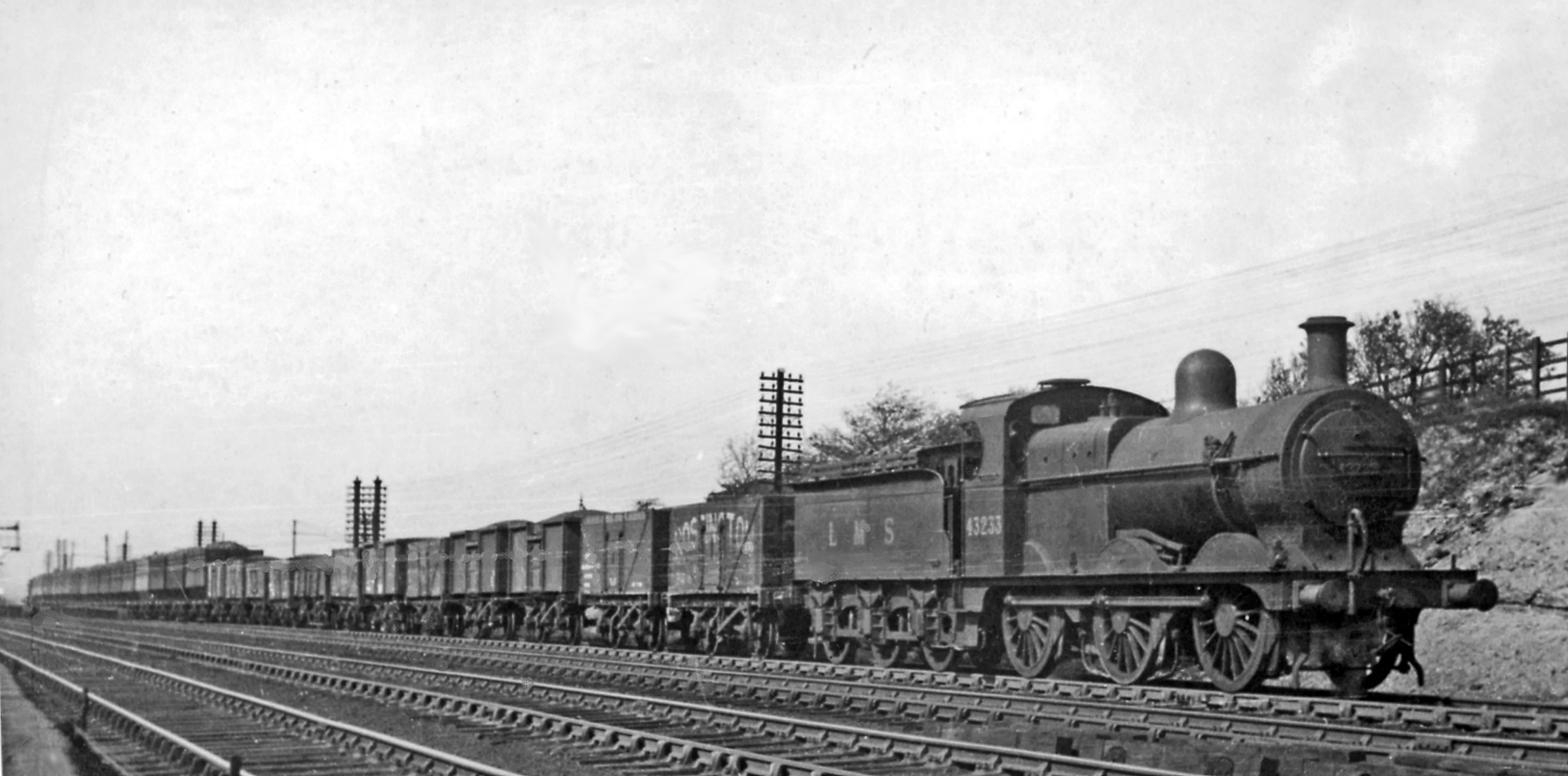
Junction and other images for details. This train is headed by ex-Midland Johnson/Deeley 5' 3" 3F 0-6-0 No. 43233, which lasted until
404:– You must give appropriate credit, provide a link to the license, and indicate if changes were made. You may do so in any reasonable manner, but not in any way that suggests the licensor endorses you or your use.
634:
1059:
1054:
69:
42:
1172:
199:
893:
720:
620:
584:
286:
740:
321:
1122:
This file contains additional information, probably added from the digital camera or scanner used to create or digitize it.
411:
547:
988:
951:
914:
859:
825:
763:
704:
675:
648:
568:
540:
527:
512:
886:
791:
748:
733:
604:
485:
468:
308:
367:
1125:
If the file has been modified from its original state, some details may not fully reflect the modified file.
410:– If you remix, transform, or build upon the material, you must distribute your contributions under the
328:
on the
Geograph website for the photographer's contact details. The copyright on this image is owned by
364:
641:"}},"text\/plain":{"en":{"P7787":"337 degree"}}}}": -->
118:
231:
770:
755:
519:
215:
143:
Adwick Upon Dearne up mineral at Wath Road
Junction geograph-2787809-by-Ben-Brooksbank.jpg
292:
333:
105:
1091:
276:
1187:
1070:
167:
188:
178:
313:
325:
1027:
Click on a date/time to view the file as it appeared at that time.
1109:
278:
263:
53° 29′ 53.93″ N, 1° 18′ 40.87″ W
253:
93:
452:
Add a one-line explanation of what this file represents
83:(2,394 × 1,184 pixels, file size: 1.15 MB, MIME type:
206:
Creative
Commons Attribution Share-alike license 2.0
137:
117:
Commons is a freely licensed media file repository.
621:
Creative
Commons Attribution-ShareAlike 2.0 Generic
421:https://creativecommons.org/licenses/by-sa/2.0
98:
427:Creative Commons Attribution-Share Alike 2.0
345:
8:
638:
387:– to copy, distribute and transmit the work
1127:
1029:
448:
1102:The following other wikis use this file:
756:https://www.geograph.org.uk/photo/2787809
520:https://www.geograph.org.uk/profile/44502
875:922bc98492dfb6df8157196d8c88aaecfef0b54a
1227:
1219:
1211:
1203:
1195:
1185:
1177:
1167:
1159:
1151:
1143:
1134:
1129:
1089:
1002:
986:
965:
949:
928:
912:
873:
857:
839:
823:
805:
789:
718:
702:
662:
646:
618:
602:
582:
566:
499:
483:
466:
463:
444:
437:
256:
285:View this and other nearby images on:
7:
1173:Adobe Photoshop Elements 3.0 Windows
332:and is licensed for reuse under the
1087:The following page uses this file:
1018:
368:Attribution-Share Alike 2.0 Generic
356:
351:
336:Attribution-ShareAlike 2.0 license.
1120:
457:
451:
342:
319:
147:
130:
76:
456:
154:Up mineral at Wath Road Junction.
649:coordinates of the point of view
442:
398:Under the following conditions:
363:This file is licensed under the
355:
350:
344:
312:
291:
277:
269:
246:Up mineral at Wath Road Junction
227:Up mineral at Wath Road Junction
97:
31:
21:
1221:Date metadata was last modified
439:
148:
14:
721:file available on the internet
438:
320:This image was taken from the
26:
1:
664:53°29'53.934"N, 1°18'40.871"W
36:
741:Geograph Britain and Ireland
541:object of statement has role
464:Items portrayed in this file
268:
1213:Date and time of digitizing
244:Ben Brooksbank /
225:Ben Brooksbank /
1249:
1106:Usage on fr.wikipedia.org
412:same or compatible license
1179:File change date and time
1019:
16:
764:geograph.org.uk image ID
441:
378:
104:This is a file from the
1076:
1055:10:01, 19 February 2012
216:required by the license
194:
184:
173:
166:
163:
140:
108:. Information from its
1224:18:10, 1 February 2012
1216:18:10, 1 February 2012
1182:18:10, 1 February 2012
326:this photograph's page
297:53.498315; -1.311353
111:description page there
46:Size of this preview:
1153:Horizontal resolution
1110:Mammouth (locomotive)
887:determination method
70:2,394 × 1,184 pixels
1161:Vertical resolution
1137:EPSON scanner image
393:– to adapt the work
52:Other resolutions:
528:author name string
66:1,280 × 633 pixels
62:1,024 × 506 pixels
1236:
1235:
1098:Global file usage
1080:
640:
605:copyright license
450:
341:
340:
324:collection. See
302:
301:
251:
250:
219:
203:
200:Reusing this file
126:
125:
106:Wikimedia Commons
32:Global file usage
1240:
1138:
1128:
1067:
1007:
970:
933:
896:
891:
773:
768:
758:
753:
749:described at URL
743:
738:
686:
685:
680:
569:copyright status
550:
545:
535:
532:
522:
517:
434:
431:
428:
425:
422:
414:as the original.
376:
365:Creative Commons
359:
358:
354:
353:
348:
347:
334:Creative Commons
322:Geograph project
316:
309:
298:
295:
281:
280:
274:
273:
272:
266:
265:
254:
213:
197:
169:
152:
144:
138:
122:
101:
100:
94:
88:
86:
73:
58:640 × 317 pixels
54:320 × 158 pixels
48:800 × 396 pixels
1248:
1247:
1243:
1242:
1241:
1239:
1238:
1237:
1136:
1116:
1096:
1081:
1073:
1065:
1021:
1020:
1017:
1016:
1015:
1014:
1013:
1012:
1011:
1010:
1008:
1005:
995:
994:
993:
991:
980:
979:
978:
977:
976:
975:
974:
973:
971:
968:
958:
957:
956:
954:
943:
942:
941:
940:
939:
938:
937:
936:
934:
931:
921:
920:
919:
917:
906:
905:
904:
903:
902:
901:
900:
899:
898:
897:
892:
889:
880:
879:
878:
876:
866:
865:
864:
862:
851:
850:
849:
848:
847:
846:
845:
844:
842:
832:
831:
830:
828:
817:
816:
815:
814:
813:
812:
811:
810:
808:
798:
797:
796:
794:
783:
782:
781:
780:
779:
778:
777:
776:
775:
774:
769:
766:
760:
759:
754:
751:
745:
744:
739:
736:
727:
726:
725:
723:
711:
710:
709:
707:
696:
695:
694:
693:
692:
691:
690:
689:
688:
687:
683:
681:
678:
669:
668:
667:
665:
655:
654:
653:
651:
632:
631:
630:
629:
628:
627:
626:
625:
623:
611:
610:
609:
607:
596:
595:
594:
593:
592:
591:
590:
589:
587:
575:
574:
573:
571:
560:
559:
558:
557:
556:
555:
554:
553:
552:
551:
546:
543:
537:
536:
533:
530:
524:
523:
518:
515:
506:
505:
504:
502:
492:
491:
490:
488:
477:
476:
475:
474:
473:
471:
455:
454:
453:
436:
435:
432:
429:
426:
423:
420:
419:
377:
374:
371:
360:
337:
307:
296:
270:
261:
260:
257:Camera location
252:
241:
234:
222:
179:geograph.org.uk
159:
142:
135:
128:
127:
116:
115:
114:is shown below.
90:
84:
82:
75:
74:
51:
12:
11:
5:
1246:
1244:
1234:
1233:
1230:
1226:
1225:
1222:
1218:
1217:
1214:
1210:
1209:
1206:
1202:
1201:
1198:
1194:
1193:
1190:
1184:
1183:
1180:
1176:
1175:
1170:
1166:
1165:
1162:
1158:
1157:
1154:
1150:
1149:
1146:
1142:
1141:
1140:
1139:
1132:
1119:
1115:
1114:
1113:
1112:
1100:
1099:
1095:
1094:
1085:
1084:
1079:
1078:
1075:
1071:
1068:
1064:2,394 × 1,184
1062:
1057:
1052:
1048:
1047:
1044:
1041:
1038:
1035:
1032:
1025:
1024:
1009:
1003:
1001:
1000:
999:
998:
997:
996:
992:
987:
985:
984:
983:
982:
981:
972:
966:
964:
963:
962:
961:
960:
959:
955:
950:
948:
947:
946:
945:
944:
935:
929:
927:
926:
925:
924:
923:
922:
918:
913:
911:
910:
909:
908:
907:
885:
884:
883:
882:
881:
877:
874:
872:
871:
870:
869:
868:
867:
863:
858:
856:
855:
854:
853:
852:
843:
840:
838:
837:
836:
835:
834:
833:
829:
824:
822:
821:
820:
819:
818:
809:
806:
804:
803:
802:
801:
800:
799:
795:
790:
788:
787:
786:
785:
784:
762:
761:
747:
746:
732:
731:
730:
729:
728:
724:
719:
717:
716:
715:
714:
713:
712:
708:
705:source of file
703:
701:
700:
699:
698:
697:
674:
673:
672:
671:
670:
666:
663:
661:
660:
659:
658:
657:
656:
652:
647:
645:
644:
643:
642:
636:
624:
619:
617:
616:
615:
614:
613:
612:
608:
603:
601:
600:
599:
598:
597:
588:
583:
581:
580:
579:
578:
577:
576:
572:
567:
565:
564:
563:
562:
561:
539:
538:
534:Ben Brooksbank
526:
525:
511:
510:
509:
508:
507:
503:
500:
498:
497:
496:
495:
494:
493:
489:
484:
482:
481:
480:
479:
478:
472:
467:
465:
462:
461:
460:
459:
458:
447:
446:
443:
440:
418:
417:
416:
415:
405:
396:
395:
394:
388:
381:You are free:
375:Ben Brooksbank
372:
362:
361:
343:
339:
338:
330:Ben Brooksbank
317:
306:
303:
300:
299:
289:
283:
258:
249:
248:
242:
239:
236:
235:
230:
223:
220:
208:
207:
204:
192:
191:
189:Ben Brooksbank
186:
182:
181:
175:
171:
170:
165:
161:
160:
145:
136:
134:
131:
129:
124:
123:
102:
92:
91:
45:
41:
40:
39:
34:
29:
24:
19:
13:
10:
9:
6:
4:
3:
2:
1245:
1231:
1228:
1223:
1220:
1215:
1212:
1207:
1204:
1199:
1196:
1191:
1189:
1186:
1181:
1178:
1174:
1171:
1169:Software used
1168:
1163:
1160:
1155:
1152:
1147:
1144:
1135:
1133:
1130:
1126:
1123:
1117:
1111:
1108:
1107:
1105:
1104:
1103:
1097:
1093:
1090:
1088:
1082:
1074:
1069:
1063:
1061:
1058:
1056:
1053:
1050:
1049:
1045:
1042:
1039:
1036:
1033:
1031:
1030:
1028:
1022:
990:
953:
916:
895:
888:
861:
827:
807:28 April 1950
793:
772:
765:
757:
750:
742:
735:
722:
706:
677:
650:
622:
606:
586:
570:
549:
542:
529:
521:
514:
487:
470:
424:CC BY-SA 2.0
413:
409:
406:
403:
400:
399:
397:
392:
389:
386:
383:
382:
380:
379:
373:Attribution:
369:
366:
349:
335:
331:
327:
323:
318:
315:
311:
310:
304:
294:
290:
288:
287:OpenStreetMap
284:
282:
264:
259:
255:
247:
243:
238:
237:
233:
229: /
228:
224:
217:
212:
210:
209:
205:
201:
196:
193:
190:
187:
183:
180:
176:
172:
168:28 April 1950
162:
156:
155:
151:
146:
139:
132:
120:
113:
112:
107:
103:
96:
95:
89:
80:
79:Original file
71:
67:
63:
59:
55:
49:
44:
38:
35:
33:
30:
28:
25:
23:
20:
18:
15:
1205:Image height
1192:Uncalibrated
1124:
1121:
1101:
1092:Drag freight
1086:
1026:
1023:File history
548:photographer
407:
401:
390:
384:
329:
267:
245:
232:CC BY-SA 2.0
226:
153:
149:
119:You can help
109:
77:
22:File history
1229:IIM version
1197:Image width
1188:Color space
1145:Orientation
1131:Image title
585:copyrighted
408:share alike
402:attribution
211:Attribution
141:Description
1083:File usage
1040:Dimensions
930:1,207,142
841:image/jpeg
826:media type
501:some value
195:Permission
85:image/jpeg
27:File usage
1066:(1.15 MB)
1037:Thumbnail
1034:Date/Time
915:data size
792:inception
305:Licensing
240:InfoField
221:InfoField
150:English:
1208:1,184 px
1200:2,394 px
1118:Metadata
860:checksum
734:operator
445:Captions
391:to remix
385:to share
370:license.
37:Metadata
1164:157 dpc
1156:157 dpc
1051:current
1046:Comment
771:2787809
676:heading
635:heading
486:creator
469:depicts
449:English
133:Summary
81:
1148:Normal
1072:Chevin
1004:2,394
967:1,184
952:height
684:degree
639:degree
275:
185:Author
174:Source
158:11/59.
1006:pixel
989:width
969:pixel
894:SHA-1
177:From
1043:User
932:byte
682:337
433:true
430:true
164:Date
17:File
513:URL
890::
767::
752::
737::
679::
544::
531::
516::
68:|
64:|
60:|
56:|
50:.
1232:2
218:)
214:(
202:)
198:(
121:.
87:)
72:.
Text is available under the Creative Commons Attribution-ShareAlike License. Additional terms may apply.
