43:
309:
270:
228:
220:
284:
242:
315:
320:
1611:
103:
1025:"}},"text\/plain":{"en":{"":"heading"}}},"{\"value\":{\"amount\":\"+315\",\"unit\":\"http:\\\/\\\/www.wikidata.org\\\/entity\\\/Q28390\"},\"type\":\"quantity\"}":{"text\/html":{"en":{"P7787":"315
1021:
65:
61:
57:
53:
47:
261:
211:
82:
114:
361:– You must give appropriate credit, provide a link to the license, and indicate if changes were made. You may do so in any reasonable manner, but not in any way that suggests the licensor endorses you or your use.
1022:
1610:
1605:
73:
42:
407:
1781:
This work is licensed under the
Creative Commons Attribution ShareAlike 4.0 International License. To view a copy of this license, visit
1444:
1390:
1142:
1008:
972:
277:
235:
838:
821:
804:
787:
770:
753:
736:
719:
702:
1908:
1733:
This file contains additional information, probably added from the digital camera or scanner used to create or digitize it.
1354:
368:
892:
1539:
1502:
1465:
1410:
1374:
1304:
1270:
1233:
1199:
1162:
1126:
1092:
1063:
1036:
956:
928:
913:
900:
885:
920:
1437:
992:
858:
686:
1338:
465:
330:
1736:
If the file has been modified from its original state, some details may not fully reflect the modified file.
1956:
367:– If you remix, transform, or build upon the material, you must distribute your contributions under the
494:
327:
1029:"}},"text\/plain":{"en":{"P7787":"315 degree"}}}}": -->
935:
1992:
1621:
122:
581:
2118:
1877:
1753:
639:
610:
523:
194:
1642:
552:
436:
174:
283:
241:
2084:
1974:
1790:
109:
302:
I, the copyright holder of this work, hereby publish it under the following license:
147:
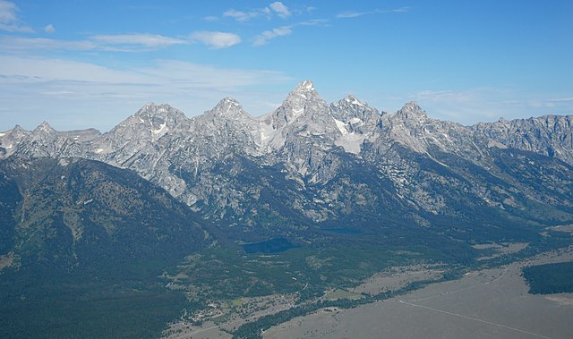
Aerial image of the
Cathedral Group of the Teton Range (view from the southeast).jpg
2128:
1830:
1843:
1782:
225:
2034:
1745:
Aerial image of the
Cathedral Group of the Teton Range (view from the southeast)
1647:
662:
Aerial image of the
Cathedral Group of the Teton Range (view from the southeast)
267:
157:
Aerial image of the
Cathedral Group of the Teton Range (view from the southeast)
1810:
2138:
1800:
1763:
1578:
Click on a date/time to view the file as it appeared at that time.
670:
Luftbild der
Cathedral Group der Teton Range (Ansicht von Südosten)
165:
Luftbild der
Cathedral Group der Teton Range (Ansicht von Südosten)
1085:
212:
43° 39′ 38.09″ N, 110° 41′ 00.07″ W
269:
227:
262:
43° 44′ 28.3″ N, 110° 48′ 07.2″ W
395:
252:
202:
97:
1705:
1685:
611:
582:
553:
524:
495:
437:
1695:
640:
1009:
Creative
Commons Attribution-ShareAlike 4.0 International
1675:
1665:
87:(5,400 × 3,200 pixels, file size: 4.77 MB, MIME type:
1720:
1715:
141:
121:
Commons is a freely licensed media file repository.
936:https://commons.wikimedia.org/User:Carsten_Steger
1844:https://creativecommons.org/licenses/by-sa/4.0/
1783:https://creativecommons.org/licenses/by-sa/4.0/
378:https://creativecommons.org/licenses/by-sa/4.0
102:
384:Creative Commons Attribution-Share Alike 4.0
308:
8:
1026:
466:
344:– to copy, distribute and transmit the work
1738:
1580:
666:
658:
1658:The following other wikis use this file:
331:Attribution-Share Alike 4.0 International
1426:de9806e0d364ff23164f7434cb5573cfc076b643
2162:
2154:
2146:
2136:
2126:
2116:
2108:
2100:
2092:
2082:
2074:
2066:
2058:
2050:
2042:
2032:
2024:
2016:
2008:
2000:
1990:
1982:
1972:
1964:
1954:
1946:
1925:
1917:
1906:
1898:
1890:
1882:
1872:
1864:
1856:
1848:
1838:
1827:
1819:
1808:
1798:
1788:
1776:
1768:
1758:
1740:
1640:
1553:
1537:
1516:
1500:
1479:
1463:
1424:
1408:
1388:
1372:
1352:
1336:
1318:
1302:
1284:
1268:
1247:
1231:
1213:
1197:
1176:
1160:
1140:
1124:
1106:
1090:
1050:
1034:
1006:
990:
970:
954:
872:
856:
836:
819:
802:
785:
768:
751:
734:
717:
700:
684:
681:
654:
647:
255:
205:
276:View this and other nearby images on:
234:View this and other nearby images on:
1748:
1638:The following 2 pages use this file:
7:
1628:Uploaded own work with UploadWizard
1569:
319:
314:
1731:
675:
669:
661:
305:
301:
159:
151:
134:
80:
674:
1821:Date and time of data generation
1037:coordinates of the point of view
652:
355:Under the following conditions:
326:This file is licensed under the
318:
313:
307:
282:
268:
240:
226:
218:
101:
31:
21:
649:
408:View the annotations at Commons
152:
14:
1108:43°44'28.298"N, 110°48'7.200"W
648:
160:
26:
1:
2063:A directly photographed image
1391:original creation by uploader
1093:coordinates of depicted place
36:
2018:DateTimeDigitized subseconds
1052:43°39'38.09"N, 110°41'0.06"W
886:object of statement has role
682:Items portrayed in this file
217:
2010:DateTimeOriginal subseconds
1919:Date and time of digitizing
2184:
2094:Focal length in 35 mm film
2047:One-chip color area sensor
2026:Supported Flashpix version
1712:Usage on www.wikidata.org
1702:Usage on nl.wikipedia.org
1692:Usage on ms.wikipedia.org
1682:Usage on it.wikipedia.org
1672:Usage on de.wikipedia.org
1662:Usage on da.wikipedia.org
369:same or compatible license
1927:Meaning of each component
1884:File change date and time
1840:URL for copyright license
1570:
405:This image is annotated:
184:
16:
651:
335:
175:10 August 2022, 10:26:53
108:This is a file from the
2068:Custom image processing
1627:
1606:10:38, 30 December 2022
190:
180:
173:
170:
144:
112:. Information from its
2148:Subject distance range
1948:Image compression mode
288:43.741194; -110.802000
246:43.660580; -110.683353
115:description page there
46:Size of this preview:
1966:Maximum land aperture
1922:10:26, 10 August 2022
1887:10:26, 10 August 2022
1858:Horizontal resolution
1824:10:26, 10 August 2022
2055:Digital still camera
1795:1/2,500 sec (0.0004)
1438:determination method
74:5,400 × 3,200 pixels
70:2,560 × 1,517 pixels
2002:DateTime subseconds
1892:Y and C positioning
1866:Vertical resolution
1750:Camera manufacturer
350:– to adapt the work
52:Other resolutions:
2102:Scene capture type
2089:Auto white balance
1997:Flash did not fire
914:Wikimedia username
901:author name string
66:1,280 × 759 pixels
62:1,024 × 607 pixels
2171:
2170:
2164:Rating (out of 5)
1969:4.1 APEX (f/4.14)
1903:Aperture priority
1754:NIKON CORPORATION
1654:Global file usage
1631:
1028:
993:copyright license
754:Teewinot Mountain
668:
660:
496:Teewinot Mountain
414:
413:
293:
292:
251:
250:
200:
199:
130:
129:
110:Wikimedia Commons
32:Global file usage
2175:
1900:Exposure Program
1778:Copyright holder
1739:
1618:
1558:
1521:
1484:
1447:
1442:
1252:
1181:
1074:
1073:
1068:
957:copyright status
938:
933:
923:
918:
908:
905:
895:
890:
642:
613:
584:
555:
526:
497:
468:
439:
396:
391:
388:
385:
382:
379:
371:as the original.
328:Creative Commons
322:
321:
317:
316:
311:
310:
289:
286:
272:
271:
265:
264:
253:
247:
244:
230:
229:
223:
222:
221:
215:
214:
203:
186:
176:
164:
156:
148:
142:
126:
105:
104:
98:
92:
90:
77:
58:640 × 379 pixels
54:320 × 190 pixels
48:800 × 474 pixels
2183:
2182:
2178:
2177:
2176:
2174:
2173:
2172:
2156:GPS tag version
1727:
1706:Cathedral Group
1686:Cathedral Group
1652:
1643:Cathedral Group
1632:
1624:
1616:
1572:
1571:
1568:
1567:
1566:
1565:
1564:
1563:
1562:
1561:
1559:
1556:
1546:
1545:
1544:
1542:
1531:
1530:
1529:
1528:
1527:
1526:
1525:
1524:
1522:
1519:
1509:
1508:
1507:
1505:
1494:
1493:
1492:
1491:
1490:
1489:
1488:
1487:
1485:
1482:
1472:
1471:
1470:
1468:
1457:
1456:
1455:
1454:
1453:
1452:
1451:
1450:
1449:
1448:
1443:
1440:
1431:
1430:
1429:
1427:
1417:
1416:
1415:
1413:
1402:
1401:
1400:
1399:
1398:
1397:
1396:
1395:
1393:
1381:
1380:
1379:
1377:
1366:
1365:
1364:
1363:
1362:
1361:
1360:
1359:
1357:
1345:
1344:
1343:
1341:
1330:
1329:
1328:
1327:
1326:
1325:
1324:
1323:
1321:
1311:
1310:
1309:
1307:
1296:
1295:
1294:
1293:
1292:
1291:
1290:
1289:
1287:
1277:
1276:
1275:
1273:
1262:
1261:
1260:
1259:
1258:
1257:
1256:
1255:
1253:
1250:
1240:
1239:
1238:
1236:
1225:
1224:
1223:
1222:
1221:
1220:
1219:
1218:
1216:
1206:
1205:
1204:
1202:
1191:
1190:
1189:
1188:
1187:
1186:
1185:
1184:
1182:
1179:
1169:
1168:
1167:
1165:
1154:
1153:
1152:
1151:
1150:
1149:
1148:
1147:
1145:
1133:
1132:
1131:
1129:
1118:
1117:
1116:
1115:
1114:
1113:
1112:
1111:
1109:
1099:
1098:
1097:
1095:
1084:
1083:
1082:
1081:
1080:
1079:
1078:
1077:
1076:
1075:
1071:
1069:
1066:
1057:
1056:
1055:
1053:
1043:
1042:
1041:
1039:
1020:
1019:
1018:
1017:
1016:
1015:
1014:
1013:
1011:
999:
998:
997:
995:
984:
983:
982:
981:
980:
979:
978:
977:
975:
963:
962:
961:
959:
948:
947:
946:
945:
944:
943:
942:
941:
940:
939:
934:
931:
925:
924:
919:
916:
910:
909:
906:
903:
897:
896:
891:
888:
879:
878:
877:
875:
865:
864:
863:
861:
850:
849:
848:
847:
846:
845:
844:
843:
841:
830:
829:
828:
827:
826:
824:
813:
812:
811:
810:
809:
807:
796:
795:
794:
793:
792:
790:
779:
778:
777:
776:
775:
773:
762:
761:
760:
759:
758:
756:
745:
744:
743:
742:
741:
739:
728:
727:
726:
725:
724:
722:
711:
710:
709:
708:
707:
705:
703:Cathedral Group
693:
692:
691:
689:
673:
672:
671:
664:
663:
646:
645:
636:
633:
630:
627:
624:
621:
617:
616:
607:
604:
601:
598:
595:
592:
588:
587:
578:
575:
572:
569:
566:
563:
559:
558:
549:
546:
543:
540:
537:
534:
530:
529:
520:
517:
514:
511:
508:
505:
501:
500:
491:
488:
485:
482:
479:
476:
472:
471:
462:
459:
456:
453:
450:
447:
443:
442:
433:
430:
427:
424:
421:
418:
402:
394:
393:
392:
389:
386:
383:
380:
377:
376:
334:
323:
304:
303:
298:
287:
260:
259:
256:Object location
245:
219:
210:
209:
206:Camera location
201:
166:
158:
146:
139:
132:
131:
120:
119:
118:is shown below.
94:
88:
86:
79:
78:
51:
12:
11:
5:
2181:
2179:
2169:
2168:
2165:
2161:
2160:
2157:
2153:
2152:
2149:
2145:
2144:
2141:
2135:
2134:
2131:
2125:
2124:
2121:
2115:
2114:
2111:
2107:
2106:
2103:
2099:
2098:
2095:
2091:
2090:
2087:
2081:
2080:
2077:
2073:
2072:
2071:Normal process
2069:
2065:
2064:
2061:
2057:
2056:
2053:
2049:
2048:
2045:
2044:Sensing method
2041:
2040:
2037:
2031:
2030:
2027:
2023:
2022:
2019:
2015:
2014:
2011:
2007:
2006:
2003:
1999:
1998:
1995:
1989:
1988:
1985:
1981:
1980:
1977:
1971:
1970:
1967:
1963:
1962:
1959:
1953:
1952:
1949:
1945:
1944:
1943:
1942:
1941:does not exist
1939:
1936:
1933:
1928:
1924:
1923:
1920:
1916:
1915:
1912:
1905:
1904:
1901:
1897:
1896:
1893:
1889:
1888:
1885:
1881:
1880:
1875:
1871:
1870:
1867:
1863:
1862:
1859:
1855:
1854:
1851:
1847:
1846:
1841:
1837:
1836:
1833:
1826:
1825:
1822:
1818:
1817:
1814:
1807:
1806:
1803:
1797:
1796:
1793:
1787:
1786:
1779:
1775:
1774:
1773:Carsten Steger
1771:
1767:
1766:
1761:
1757:
1756:
1751:
1747:
1746:
1743:
1730:
1726:
1725:
1724:
1723:
1718:
1710:
1709:
1708:
1700:
1699:
1698:
1696:Banjaran Teton
1690:
1689:
1688:
1680:
1679:
1678:
1670:
1669:
1668:
1656:
1655:
1651:
1650:
1645:
1636:
1635:
1630:
1629:
1626:
1623:Carsten Steger
1622:
1619:
1615:5,400 × 3,200
1613:
1608:
1603:
1599:
1598:
1595:
1592:
1589:
1586:
1583:
1576:
1575:
1560:
1554:
1552:
1551:
1550:
1549:
1548:
1547:
1543:
1538:
1536:
1535:
1534:
1533:
1532:
1523:
1517:
1515:
1514:
1513:
1512:
1511:
1510:
1506:
1501:
1499:
1498:
1497:
1496:
1495:
1486:
1480:
1478:
1477:
1476:
1475:
1474:
1473:
1469:
1464:
1462:
1461:
1460:
1459:
1458:
1436:
1435:
1434:
1433:
1432:
1428:
1425:
1423:
1422:
1421:
1420:
1419:
1418:
1414:
1409:
1407:
1406:
1405:
1404:
1403:
1394:
1389:
1387:
1386:
1385:
1384:
1383:
1382:
1378:
1375:source of file
1373:
1371:
1370:
1369:
1368:
1367:
1358:
1353:
1351:
1350:
1349:
1348:
1347:
1346:
1342:
1337:
1335:
1334:
1333:
1332:
1331:
1322:
1319:
1317:
1316:
1315:
1314:
1313:
1312:
1308:
1303:
1301:
1300:
1299:
1298:
1297:
1288:
1285:
1283:
1282:
1281:
1280:
1279:
1278:
1274:
1269:
1267:
1266:
1265:
1264:
1263:
1254:
1248:
1246:
1245:
1244:
1243:
1242:
1241:
1237:
1232:
1230:
1229:
1228:
1227:
1226:
1217:
1214:
1212:
1211:
1210:
1209:
1208:
1207:
1203:
1198:
1196:
1195:
1194:
1193:
1192:
1183:
1177:
1175:
1174:
1173:
1172:
1171:
1170:
1166:
1161:
1159:
1158:
1157:
1156:
1155:
1146:
1141:
1139:
1138:
1137:
1136:
1135:
1134:
1130:
1125:
1123:
1122:
1121:
1120:
1119:
1110:
1107:
1105:
1104:
1103:
1102:
1101:
1100:
1096:
1091:
1089:
1088:
1087:
1086:
1062:
1061:
1060:
1059:
1058:
1054:
1051:
1049:
1048:
1047:
1046:
1045:
1044:
1040:
1035:
1033:
1032:
1031:
1030:
1024:
1012:
1007:
1005:
1004:
1003:
1002:
1001:
1000:
996:
991:
989:
988:
987:
986:
985:
976:
971:
969:
968:
967:
966:
965:
964:
960:
955:
953:
952:
951:
950:
949:
927:
926:
921:Carsten Steger
912:
911:
907:Carsten Steger
899:
898:
884:
883:
882:
881:
880:
876:
873:
871:
870:
869:
868:
867:
866:
862:
857:
855:
854:
853:
852:
851:
842:
837:
835:
834:
833:
832:
831:
825:
820:
818:
817:
816:
815:
814:
808:
805:Nez Perce Peak
803:
801:
800:
799:
798:
797:
791:
786:
784:
783:
782:
781:
780:
774:
769:
767:
766:
765:
764:
763:
757:
752:
750:
749:
748:
747:
746:
740:
735:
733:
732:
731:
730:
729:
723:
718:
716:
715:
714:
713:
712:
706:
701:
699:
698:
697:
696:
695:
694:
690:
685:
683:
680:
679:
678:
677:
676:
665:
657:
656:
653:
650:
637:
634:
631:
628:
625:
622:
619:
618:
608:
605:
602:
599:
596:
593:
590:
589:
583:Nez Perce Peak
579:
576:
573:
570:
567:
564:
561:
560:
550:
547:
544:
541:
538:
535:
532:
531:
521:
518:
515:
512:
509:
506:
503:
502:
492:
489:
486:
483:
480:
477:
474:
473:
463:
460:
457:
454:
451:
448:
445:
444:
434:
431:
428:
425:
422:
419:
416:
415:
412:
411:
403:
400:
375:
374:
373:
372:
362:
353:
352:
351:
345:
338:You are free:
325:
324:
306:
300:
299:
297:
294:
291:
290:
280:
274:
257:
249:
248:
238:
232:
207:
198:
197:
195:Carsten Steger
192:
188:
187:
182:
178:
177:
172:
168:
167:
149:
140:
138:
135:
133:
128:
127:
106:
96:
95:
45:
41:
40:
39:
34:
29:
24:
19:
13:
10:
9:
6:
4:
3:
2:
2180:
2166:
2163:
2158:
2155:
2150:
2147:
2142:
2140:
2137:
2132:
2130:
2127:
2122:
2120:
2117:
2112:
2110:Scene control
2109:
2104:
2101:
2096:
2093:
2088:
2086:
2085:White balance
2083:
2079:Auto exposure
2078:
2076:Exposure mode
2075:
2070:
2067:
2062:
2059:
2054:
2051:
2046:
2043:
2038:
2036:
2033:
2028:
2025:
2020:
2017:
2012:
2009:
2004:
2001:
1996:
1994:
1991:
1986:
1983:
1978:
1976:
1975:Metering mode
1973:
1968:
1965:
1960:
1958:
1957:Exposure bias
1955:
1950:
1947:
1940:
1937:
1934:
1931:
1930:
1929:
1926:
1921:
1918:
1913:
1910:
1907:
1902:
1899:
1894:
1891:
1886:
1883:
1879:
1876:
1874:Software used
1873:
1868:
1865:
1860:
1857:
1852:
1849:
1845:
1842:
1839:
1834:
1832:
1828:
1823:
1820:
1815:
1812:
1809:
1804:
1802:
1799:
1794:
1792:
1791:Exposure time
1789:
1784:
1780:
1777:
1772:
1769:
1765:
1762:
1759:
1755:
1752:
1749:
1744:
1741:
1737:
1734:
1728:
1722:
1719:
1717:
1714:
1713:
1711:
1707:
1704:
1703:
1701:
1697:
1694:
1693:
1691:
1687:
1684:
1683:
1681:
1677:
1674:
1673:
1671:
1667:
1664:
1663:
1661:
1660:
1659:
1653:
1649:
1646:
1644:
1641:
1639:
1633:
1625:
1620:
1614:
1612:
1609:
1607:
1604:
1601:
1600:
1596:
1593:
1590:
1587:
1584:
1582:
1581:
1579:
1573:
1541:
1504:
1467:
1446:
1439:
1412:
1392:
1376:
1356:
1340:
1306:
1272:
1235:
1201:
1164:
1163:exposure time
1144:
1128:
1127:captured with
1094:
1065:
1038:
1010:
994:
974:
958:
937:
930:
922:
915:
902:
894:
887:
860:
840:
823:
806:
789:
772:
755:
738:
721:
704:
688:
644:
643:
615:
614:
586:
585:
557:
556:
528:
527:
499:
498:
470:
469:
441:
440:
410:
409:
404:
398:
397:
381:CC BY-SA 4.0
370:
366:
363:
360:
357:
356:
354:
349:
346:
343:
340:
339:
337:
336:
332:
329:
312:
295:
285:
281:
279:
278:OpenStreetMap
275:
273:
263:
258:
254:
243:
239:
237:
236:OpenStreetMap
233:
231:
213:
208:
204:
196:
193:
189:
183:
179:
169:
163:
155:
150:
143:
136:
124:
117:
116:
111:
107:
100:
99:
93:
84:
83:Original file
75:
71:
67:
63:
59:
55:
49:
44:
38:
35:
33:
30:
28:
25:
23:
20:
18:
15:
1984:Light source
1831:focal length
1760:Camera model
1735:
1732:
1657:
1637:
1577:
1574:File history
1234:focal length
893:photographer
839:Taggart Lake
822:Bradley Lake
771:Middle Teton
641:Taggart Lake
638:
612:Bradley Lake
609:
580:
551:
525:Middle Teton
522:
493:
464:
435:
406:
364:
358:
347:
341:
216:
161:
153:
123:You can help
113:
81:
22:File history
2113:Low gain up
2052:File source
2035:Color space
1850:Orientation
1742:Image title
1676:Teton Range
1666:Teton Range
1648:Teton Range
1339:instance of
973:copyrighted
788:South Teton
720:Grand Teton
554:South Teton
438:Grand Teton
399:Annotations
365:share alike
359:attribution
145:Description
2129:Saturation
2060:Scene type
1634:File usage
1591:Dimensions
1481:4,998,577
1355:photograph
1320:image/jpeg
1305:media type
1251:millimetre
874:some value
737:Mount Owen
467:Mount Owen
89:image/jpeg
27:File usage
2139:Sharpness
1878:Ver.1.30
1811:ISO speed
1617:(4.77 MB)
1588:Thumbnail
1585:Date/Time
1466:data size
1271:ISO speed
401:InfoField
296:Licensing
162:Deutsch:
154:English:
2119:Contrast
2105:Standard
1895:Co-sited
1801:F-number
1764:NIKON D5
1729:Metadata
1721:Q3663570
1411:checksum
1200:f-number
1143:Nikon D5
655:Captions
348:to remix
342:to share
333:license.
185:Own work
37:Metadata
2159:0.0.3.2
2151:Unknown
1987:Unknown
1979:Pattern
1911:version
1869:300 dpi
1861:300 dpi
1716:Q586241
1602:current
1597:Comment
1178:0.0004
1064:heading
1023:heading
859:creator
687:depicts
659:English
137:Summary
85:
2143:Normal
2133:Normal
2123:Normal
1853:Normal
1813:rating
1770:Author
1555:5,400
1518:3,200
1503:height
1180:second
1072:degree
1027:degree
667:German
266:
224:
191:Author
181:Source
2097:45 mm
1993:Flash
1835:45 mm
1829:Lens
1557:pixel
1540:width
1520:pixel
1445:SHA-1
2039:sRGB
1914:2.31
1909:Exif
1805:f/10
1594:User
1483:byte
1070:315
635:3200
632:5400
623:2214
620:2241
606:3200
603:5400
594:2100
591:3011
577:3200
574:5400
565:1013
562:1877
548:3200
545:5400
533:1296
519:3200
516:5400
504:2012
490:3200
487:5400
475:3726
461:3200
458:5400
446:3159
432:3200
429:5400
417:2700
390:true
387:true
171:Date
17:File
1816:800
1286:800
1249:45
929:URL
629:209
626:601
600:155
597:419
571:135
568:250
542:176
539:331
536:945
513:155
510:304
507:884
484:182
481:304
478:932
455:155
452:284
449:864
426:203
423:338
420:743
2021:43
2013:43
2005:43
1938:Cr
1935:Cb
1441::
1215:10
1067::
932::
917::
904::
889::
72:|
68:|
64:|
60:|
56:|
50:.
2167:0
2029:1
1961:0
1951:4
1932:Y
1785:.
125:.
91:)
76:.
Text is available under the Creative Commons Attribution-ShareAlike License. Additional terms may apply.

.jpg)
.jpg¶ms=043.660580_N_-110.683353_E_globe:Earth_type:camera_heading:315.00&language=en)
.jpg¶ms=043.741194_N_-110.802000_E_globe:Earth_class:object_type:object__&language=en)