38:
359:
77:
109:
760:
321:
98:
840:
Image courtesy of USDA Farm
Service Agency's National Agriculture Imagery Program (NAIP) under Aerial Photography Field Office contract 12FPC220F0040. Imagery has been placed in the public domain and may be used and reproduced without permission or fee. Please credit 'NAIP imagery provided by USDA
64:
60:
56:
52:
48:
42:
141:
759:
754:
68:
37:
188:
is at the bottom right. More of
Gardner is shown than any other particular town and the village of Forestville is not pictured. The divided highway running southwest through northeast is
158:
Aerial view of southeastern
Gardner, southwestern Nasewaupee, northeastern Brussels, and northwestern Forestville, all four towns in Door County, Wisconsin 2020.png
265:
340:
332:
336:
288:
137:
The original file is very high-resolution. It might not load properly or could cause your browser to freeze when opened at full size.
593:
470:
825:
This file contains additional information, probably added from the digital camera or scanner used to create or digitize it.
185:
777:
797:
435:
328:
202:
688:
651:
614:
559:
525:
448:
419:
586:
491:
463:
402:
455:
828:
If the file has been modified from its original state, some details may not fully reflect the modified file.
169:
781:
177:
789:
189:
770:
181:
810:
The following pages on the
English Knowledge use this file (pages on other projects are not listed):
793:
173:
785:
117:
279:
Aerial
Photography Field Office (APFO) for NAIP, USGS; in contract with the Surdex Corporation
198:
800:
is at the bottom right. More of
Gardner is shown than any other particular town and the...
345:
193:
814:
104:
335:
domestic photographic units, taken as part of that person's official duties. As a
780:: {{Information | Description = {{en|1=Aerial view of part of four towns in
350:
254:
206:
196:
flows south somewhat left of the center in the lower part of the photograph.
860:
268:
from the original .tif available as item M_4408712_SE_16_060_20200627 on
727:
Click on a date/time to view the file as it appeared at that time.
269:
315:
130:
92:
327:
This image is a work of an employee of the United States
82:(9,252 × 12,717 pixels, file size: 213.38 MB, MIME type:
386:
Add a one-line explanation of what this file represents
152:
116:
Commons is a freely licensed media file repository.
471:
work of the federal government of the United States
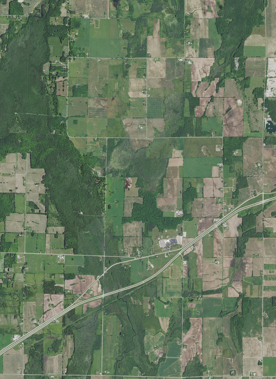
784:, Wisconsin, taken June 27, 2020. The four towns:
172:, Wisconsin, taken June 27, 2020. The four towns:
97:
8:
852:xmp.did:bba785ec-945d-477a-87db-dac68a240109
830:
729:
382:
295:
575:36e8240cfe9fea0870770cca6cd9656fd63029f7
881:
873:
865:
855:
847:
837:
832:
812:
702:
686:
665:
649:
628:
612:
573:
557:
539:
523:
505:
489:
433:
417:
400:
397:
378:
371:
133:
209:is near the center of the photograph.
320:
168:Aerial view of part of four towns in
7:
718:
823:
391:
385:
162:
129:
75:
778:c:User:Rillke/bigChunkedUpload.js
390:
205:(center) are recreational areas.
841:Farm Service Agency' on any use.
376:
357:
319:
96:
21:
373:
163:
14:
849:Unique ID of original document
372:
219:Center Longitude 87°31'51.66"W
26:
1:
216:Center Latitude 44°46'53.40"N
31:
398:Items portrayed in this file
329:Farm Security Administration
243:SW Corner Long 87°33'56.75"W
237:SE Corner Long 87°29'44.31"W
231:NE Corner Long 87°29'46.42"W
225:NW Corner Long 87°33'59.16"W
199:Tornado Memorial County Park
796:is at the bottom left, and
349:in the United States. See
240:SW Corner Lat 44°44'49.16"N
234:SE Corner Lat 44°44'50.33"N
228:NE Corner Lat 44°48'57.61"N
222:NW Corner Lat 44°48'56.43"N
184:is at the bottom left, and
903:
883:File change date and time
719:
333:Office of War Information
16:
782:w:Door County, Wisconsin
456:United States of America
375:
103:This is a file from the
776:
449:applies to jurisdiction
341:U.S. federal government
283:
275:
260:
253:
250:
155:
107:. Information from its
343:, the image is in the
110:description page there
41:Size of this preview:
867:Horizontal resolution
792:is at the top right,
264:converted to .png by
201:(lower left) and the
180:is at the top right,
69:9,252 × 12,717 pixels
886:18:21, 10 March 2022
788:is at the top left,
755:13:07, 17 March 2022
587:determination method
464:determination method
207:Southern Door School
190:Wisconsin Highway 57
176:is at the top left,
65:1,490 × 2,048 pixels
875:Vertical resolution
203:Eagle Walking Trail
47:Other resolutions:
143:Open in ZoomViewer
61:745 × 1,024 pixels
890:
889:
803:
384:
369:
368:
365:
364:
314:
313:
292:
289:Reusing this file
150:
149:
125:
124:
105:Wikimedia Commons
894:
842:
834:PNG file comment
831:
767:
707:
670:
633:
596:
591:
473:
468:
458:
453:
420:copyright status
361:
360:
323:
322:
316:
310:
307:
304:
301:
296:
286:
256:
167:
159:
153:
146:
144:
131:
121:
100:
99:
93:
87:
85:
72:
57:559 × 768 pixels
53:349 × 480 pixels
49:174 × 240 pixels
43:436 × 599 pixels
902:
901:
897:
896:
895:
893:
892:
891:
839:
819:
811:
804:
773:
772:Epiphyllumlover
765:
764:9,252 × 12,717
721:
720:
717:
716:
715:
714:
713:
712:
711:
710:
708:
705:
695:
694:
693:
691:
680:
679:
678:
677:
676:
675:
674:
673:
671:
668:
658:
657:
656:
654:
643:
642:
641:
640:
639:
638:
637:
636:
634:
631:
621:
620:
619:
617:
606:
605:
604:
603:
602:
601:
600:
599:
598:
597:
592:
589:
580:
579:
578:
576:
566:
565:
564:
562:
551:
550:
549:
548:
547:
546:
545:
544:
542:
532:
531:
530:
528:
517:
516:
515:
514:
513:
512:
511:
510:
508:
498:
497:
496:
494:
483:
482:
481:
480:
479:
478:
477:
476:
475:
474:
469:
466:
460:
459:
454:
451:
442:
441:
440:
438:
426:
425:
424:
422:
411:
410:
409:
408:
407:
405:
389:
388:
387:
370:
358:
308:
305:
302:
299:
266:Epiphyllumlover
246:
157:
142:
140:
127:
126:
115:
114:
113:is shown below.
89:
83:
81:
74:
73:
46:
12:
11:
5:
900:
898:
888:
887:
884:
880:
879:
876:
872:
871:
868:
864:
863:
858:
854:
853:
850:
846:
845:
844:
843:
835:
822:
818:
817:
809:
808:
807:
802:
801:
775:
771:
768:
762:
757:
752:
748:
747:
744:
741:
738:
735:
732:
725:
724:
709:
703:
701:
700:
699:
698:
697:
696:
692:
687:
685:
684:
683:
682:
681:
672:
666:
664:
663:
662:
661:
660:
659:
655:
650:
648:
647:
646:
645:
644:
635:
629:
627:
626:
625:
624:
623:
622:
618:
613:
611:
610:
609:
608:
607:
585:
584:
583:
582:
581:
577:
574:
572:
571:
570:
569:
568:
567:
563:
558:
556:
555:
554:
553:
552:
543:
540:
538:
537:
536:
535:
534:
533:
529:
524:
522:
521:
520:
519:
518:
509:
506:
504:
503:
502:
501:
500:
499:
495:
490:
488:
487:
486:
485:
484:
462:
461:
447:
446:
445:
444:
443:
439:
434:
432:
431:
430:
429:
428:
427:
423:
418:
416:
415:
414:
413:
412:
406:
401:
399:
396:
395:
394:
393:
392:
381:
380:
377:
374:
367:
366:
363:
362:
355:
324:
312:
311:
293:
281:
280:
277:
273:
272:
262:
258:
257:
252:
248:
247:
245:
244:
241:
238:
235:
232:
229:
226:
223:
220:
217:
160:
151:
148:
147:
138:
135:
128:
123:
122:
101:
91:
90:
40:
36:
35:
34:
29:
24:
19:
13:
10:
9:
6:
4:
3:
2:
899:
885:
882:
877:
874:
869:
866:
862:
859:
857:Software used
856:
851:
848:
838:
836:
833:
829:
826:
820:
816:
815:Ahnapee River
813:
805:
799:
795:
791:
787:
783:
779:
774:
769:
763:
761:
758:
756:
753:
750:
749:
745:
742:
739:
736:
733:
731:
730:
728:
722:
690:
653:
616:
595:
588:
561:
527:
493:
472:
465:
457:
450:
437:
436:public domain
421:
404:
356:
354:
352:
348:
347:
346:public domain
342:
338:
334:
330:
325:
318:
317:
303:Public domain
300:Public domain
298:
297:
294:
290:
285:
282:
278:
274:
271:
270:EarthExplorer
267:
263:
259:
249:
242:
239:
236:
233:
230:
227:
224:
221:
218:
215:
214:
213:
212:Coordinates:
210:
208:
204:
200:
195:
194:Ahnapee River
191:
187:
183:
179:
175:
171:
166:
161:
154:
145:
139:
136:
132:
119:
112:
111:
106:
102:
95:
94:
88:
79:
78:Original file
70:
66:
62:
58:
54:
50:
44:
39:
33:
30:
28:
25:
23:
20:
18:
15:
827:
824:
726:
723:File history
630:223,740,029
507:27 June 2020
344:
326:
255:27 June 2020
211:
197:
164:
118:You can help
108:
76:
22:File history
798:Forestville
766:(213.38 MB)
186:Forestville
170:Door County
156:Description
806:File usage
790:Nasewaupee
740:Dimensions
526:media type
284:Permission
178:Nasewaupee
27:File usage
878:28.35 dpc
870:28.35 dpc
861:GIMP 2.10
737:Thumbnail
734:Date/Time
615:data size
541:image/png
492:inception
351:Copyright
165:English:
84:image/png
821:Metadata
794:Brussels
560:checksum
379:Captions
182:Brussels
134:Warning
32:Metadata
786:Gardner
751:current
746:Comment
667:12,717
403:depicts
383:English
339:of the
174:Gardner
80:
704:9,252
652:height
276:Author
261:Source
192:. The
706:pixel
689:width
669:pixel
594:SHA-1
309:false
306:false
743:User
632:byte
337:work
251:Date
17:File
331:or
590::
467::
452::
67:|
63:|
59:|
55:|
51:|
45:.
353:.
291:)
287:(
120:.
86:)
71:.
Text is available under the Creative Commons Attribution-ShareAlike License. Additional terms may apply.
