280:
247:
356:
261:
286:
43:
91:
150:
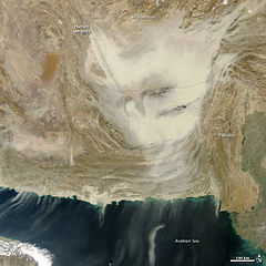
The storm is being propelled by strong winds from the north. The winds picked up dust from the dry lakebeds in the Hamun wetlands on the border between
Afghanistan and Iran. Concentrated plumes of dust rise from the pale wetlands to become a more diffuse cloud in the south and east. Dry lakebeds and
1073:
146:
A dense cloud of dust swept across southern
Afghanistan and Pakistan on December 20, 2011. When the Moderate Resolution Imaging Spectroradiometer (MODIS) took this image from the Terra satellite at 10:45 a.m., the dust was largely hemmed in by the Makran and Sulaiman Ranges in Pakistan with only a
154:
Dust storms can happen any time of the year in
Afghanistan. On average, Afghanistan experiences blowing dust one to two days per month in the winter and six days per month at the height of the summer. Zabon, an Iranian city located near the border in the Hamun wetlands, reports 81 dust storms per
430:
158:
Blowing dust poses a hazard to transportation. Low visibility closes roads and airports. This particular storm prevented
British Prime Minister David Cameron from visiting a British military base as planned because the runway was closed due to low visibility.
238:
171:
mission is to share with the public the images, stories, and discoveries about climate and the environment that emerge from NASA research, including its satellite missions, in-the-field research, and climate models.
327:– You must give appropriate credit, provide a link to the license, and indicate if changes were made. You may do so in any reasonable manner, but not in any way that suggests the licensor endorses you or your use.
147:
few wisps reaching south over the
Arabian Sea. By the time Aqua MODIS flew over just over three hours later, the storm had reached the coast. The dust storm continued on December 21.
57:
53:
47:
102:
70:
1122:
1142:
1090:== {{int:filedesc}} == {{Information |Description=To download the full resolution and other files go to: A dense cloud of dus...
870:
663:
627:
591:
254:
1155:
This file contains additional information, probably added from the digital camera or scanner used to create or digitize it.
698:
536:
1175:
1002:
965:
928:
891:
836:
802:
734:
706:
647:
575:
520:
494:
479:
464:
863:
768:
691:
676:
611:
549:
437:
420:
1072:
1067:
61:
42:
162:
NASA image courtesy Jeff
Schmaltz, LANCE/EOSDIS MODIS Rapid Response Team at NASA GSFC. Caption by Holli Riebeek.
713:
683:
1158:
If the file has been modified from its original state, some details may not fully reflect the modified file.
141:
296:
1104:
293:
1018:
211:
110:
471:
486:
1132:
368:
374:
260:
192:
1083:
97:
177:
244:
167:
221:
363:
1040:
Click on a date/time to view the file as it appeared at that time.
379:
and was confirmed to be licensed under the terms of the cc-by-2.0.
727:
151:
wetlands are among the most common sources of dust in the world.
246:
239:
30° 09′ 59.4″ N, 63° 33′ 41.04″ E
714:
https://live.staticflickr.com/7020/6554717663_91769ff775_o.jpg
684:
https://www.flickr.com/photos/nasaearthobservatory/6554717663/
229:
185:
85:
142:
earthobservatory.nasa.gov/IOTD/view.php?id=76763&src=...
404:
Add a one-line explanation of what this file represents
140:
To download the full resolution and other files go to:
369:
https://www.flickr.com/photos/68824346@N02/6554717663
129:
109:
Commons is a freely licensed media file repository.
135:
75:(720 × 720 pixels, file size: 157 KB, MIME type:
90:
279:
8:
334:https://creativecommons.org/licenses/by/2.0
310:– to copy, distribute and transmit the work
1160:
1042:
487:https://www.flickr.com/people/68824346@N02
400:
1115:The following other wikis use this file:
1167:xmp.did:F77F1174072068118E6393AAB12F22A7
852:94fd9041a97ee4d586efa553c8487a0c63dde4f1
628:Creative Commons Attribution 2.0 Generic
1170:
1162:
1102:
1016:
1000:
979:
963:
942:
926:
905:
889:
850:
834:
816:
800:
782:
766:
748:
732:
661:
645:
625:
609:
589:
573:
534:
518:
451:
435:
418:
415:
396:
389:
232:
253:View this and other nearby images on:
203:Taken on 20 December 2011, 00:00
7:
371:. It was reviewed on 2 July 2012 by
361:This image was originally posted to
350:
1100:The following page uses this file:
1031:
285:
1153:
409:
403:
301:
276:
122:
68:
408:
340:Creative Commons Attribution 2.0
735:coordinates of the point of view
394:
354:
321:Under the following conditions:
292:This file is licensed under the
284:
278:
259:
245:
89:
31:
21:
391:
14:
1164:Unique ID of original document
664:file available on the internet
390:
26:
1:
1176:Adobe Photoshop CS5 Macintosh
750:30°9'59.400"N, 63°33'41.044"E
367:by NASA Earth Observatory at
36:
416:Items portrayed in this file
1194:
1139:Usage on ur.wikipedia.org
1129:Usage on hi.wikipedia.org
1119:Usage on fa.wikipedia.org
191:Add us to your circles on
1032:
16:
501:NASA's Earth Observatory
393:
222:NASA's Earth Observatory
96:This is a file from the
1089:
297:Attribution 2.0 Generic
217:
207:
202:
199:
132:
100:. Information from its
265:30.166500; 63.561401
212:Afghanistan Dust Storm
103:description page there
46:Size of this preview:
1123:رشتهکوه ساحلی مکران
1105:Makran Coastal Range
864:determination method
316:– to adapt the work
168:Earth Observatory's
52:Other resolutions:
1068:17:16, 2 July 2012
495:author name string
1181:
1180:
1111:Global file usage
1093:
612:copyright license
402:
383:
382:
270:
269:
227:
226:
118:
117:
98:Wikimedia Commons
32:Global file usage
1185:
1161:
1143:سلسلہ ساحل مکران
1080:
1003:Flickr photo ID
984:
947:
910:
873:
868:
784:20 December 2011
716:
711:
701:
696:
686:
681:
677:described at URL
576:copyright status
557:
556:22 December 2011
554:
550:publication date
502:
499:
489:
484:
474:
469:
387:
377:
358:
357:
351:
347:
344:
341:
338:
335:
294:Creative Commons
288:
287:
282:
281:
266:
263:
249:
248:
242:
241:
230:
136:
130:
114:
93:
92:
86:
80:
78:
65:
62:720 × 720 pixels
58:480 × 480 pixels
54:240 × 240 pixels
48:600 × 600 pixels
1193:
1192:
1188:
1187:
1186:
1184:
1183:
1182:
1149:
1109:
1094:
1086:
1078:
1034:
1033:
1030:
1029:
1028:
1027:
1026:
1025:
1024:
1023:
1021:
1009:
1008:
1007:
1005:
994:
993:
992:
991:
990:
989:
988:
987:
985:
982:
972:
971:
970:
968:
957:
956:
955:
954:
953:
952:
951:
950:
948:
945:
935:
934:
933:
931:
920:
919:
918:
917:
916:
915:
914:
913:
911:
908:
898:
897:
896:
894:
883:
882:
881:
880:
879:
878:
877:
876:
875:
874:
869:
866:
857:
856:
855:
853:
843:
842:
841:
839:
828:
827:
826:
825:
824:
823:
822:
821:
819:
809:
808:
807:
805:
794:
793:
792:
791:
790:
789:
788:
787:
785:
775:
774:
773:
771:
760:
759:
758:
757:
756:
755:
754:
753:
751:
741:
740:
739:
737:
726:
725:
724:
723:
722:
721:
720:
719:
718:
717:
712:
709:
703:
702:
697:
694:
688:
687:
682:
679:
670:
669:
668:
666:
654:
653:
652:
650:
639:
638:
637:
636:
635:
634:
633:
632:
630:
618:
617:
616:
614:
603:
602:
601:
600:
599:
598:
597:
596:
594:
582:
581:
580:
578:
567:
566:
565:
564:
563:
562:
561:
560:
559:
558:
555:
552:
543:
542:
541:
539:
527:
526:
525:
523:
512:
511:
510:
509:
508:
507:
506:
505:
504:
503:
500:
497:
491:
490:
485:
482:
476:
475:
470:
467:
458:
457:
456:
454:
444:
443:
442:
440:
429:
428:
427:
426:
425:
423:
407:
406:
405:
385:
373:
355:
349:
348:
345:
342:
339:
336:
333:
332:
300:
289:
275:
264:
237:
236:
233:Camera location
228:
134:
127:
120:
119:
108:
107:
106:is shown below.
82:
76:
74:
67:
66:
51:
12:
11:
5:
1191:
1189:
1179:
1178:
1173:
1169:
1168:
1165:
1152:
1148:
1147:
1146:
1145:
1137:
1136:
1135:
1127:
1126:
1125:
1113:
1112:
1108:
1107:
1098:
1097:
1092:
1091:
1088:
1084:
1081:
1075:
1070:
1065:
1061:
1060:
1057:
1054:
1051:
1048:
1045:
1038:
1037:
1022:
1017:
1015:
1014:
1013:
1012:
1011:
1010:
1006:
1001:
999:
998:
997:
996:
995:
986:
980:
978:
977:
976:
975:
974:
973:
969:
964:
962:
961:
960:
959:
958:
949:
943:
941:
940:
939:
938:
937:
936:
932:
927:
925:
924:
923:
922:
921:
912:
906:
904:
903:
902:
901:
900:
899:
895:
890:
888:
887:
886:
885:
884:
862:
861:
860:
859:
858:
854:
851:
849:
848:
847:
846:
845:
844:
840:
835:
833:
832:
831:
830:
829:
820:
817:
815:
814:
813:
812:
811:
810:
806:
801:
799:
798:
797:
796:
795:
786:
783:
781:
780:
779:
778:
777:
776:
772:
767:
765:
764:
763:
762:
761:
752:
749:
747:
746:
745:
744:
743:
742:
738:
733:
731:
730:
729:
728:
705:
704:
690:
689:
675:
674:
673:
672:
671:
667:
662:
660:
659:
658:
657:
656:
655:
651:
648:source of file
646:
644:
643:
642:
641:
640:
631:
626:
624:
623:
622:
621:
620:
619:
615:
610:
608:
607:
606:
605:
604:
595:
590:
588:
587:
586:
585:
584:
583:
579:
574:
572:
571:
570:
569:
568:
548:
547:
546:
545:
544:
540:
535:
533:
532:
531:
530:
529:
528:
524:
519:
517:
516:
515:
514:
513:
493:
492:
478:
477:
465:Flickr user ID
463:
462:
461:
460:
459:
455:
452:
450:
449:
448:
447:
446:
445:
441:
436:
434:
433:
432:
431:
424:
419:
417:
414:
413:
412:
411:
410:
399:
398:
395:
392:
381:
380:
359:
331:
330:
329:
328:
319:
318:
317:
311:
304:You are free:
291:
290:
277:
274:
271:
268:
267:
257:
251:
234:
225:
224:
219:
215:
214:
209:
205:
204:
201:
197:
196:
137:
128:
126:
123:
121:
116:
115:
94:
84:
83:
45:
41:
40:
39:
34:
29:
24:
19:
13:
10:
9:
6:
4:
3:
2:
1190:
1177:
1174:
1172:Software used
1171:
1166:
1163:
1159:
1156:
1150:
1144:
1141:
1140:
1138:
1134:
1131:
1130:
1128:
1124:
1121:
1120:
1118:
1117:
1116:
1110:
1106:
1103:
1101:
1095:
1087:
1082:
1076:
1074:
1071:
1069:
1066:
1063:
1062:
1058:
1055:
1052:
1049:
1046:
1044:
1043:
1041:
1035:
1020:
1004:
967:
930:
893:
872:
865:
838:
804:
770:
736:
715:
708:
700:
693:
685:
678:
665:
649:
629:
613:
593:
577:
551:
538:
522:
496:
488:
481:
473:
466:
439:
422:
388:
378:
376:
370:
366:
365:
360:
353:
352:
326:
323:
322:
320:
315:
312:
309:
306:
305:
303:
302:
298:
295:
283:
272:
262:
258:
256:
255:OpenStreetMap
252:
250:
240:
235:
231:
223:
220:
216:
213:
210:
206:
198:
195:
194:
189:
188:
187:
184:Follow us on
181:
180:
179:
173:
170:
169:
163:
160:
156:
152:
148:
144:
143:
138:
131:
124:
112:
105:
104:
99:
95:
88:
87:
81:
72:
71:Original file
63:
59:
55:
49:
44:
38:
35:
33:
30:
28:
25:
23:
20:
18:
15:
1157:
1154:
1114:
1099:
1039:
1036:File history
521:published in
472:68824346@N02
384:
375:FlickreviewR
372:
362:
324:
313:
307:
190:
183:
182:
175:
174:
166:
164:
161:
157:
153:
149:
145:
139:
111:You can help
101:
69:
22:File history
592:copyrighted
386:2 July 2012
325:attribution
176:Like us on
133:Description
1096:File usage
1077:720 × 720
1053:Dimensions
1019:6554717663
818:image/jpeg
803:media type
453:some value
337:CC BY 2.0
77:image/jpeg
27:File usage
1050:Thumbnail
1047:Date/Time
892:data size
769:inception
273:Licensing
1151:Metadata
1085:Dzlinker
1079:(157 KB)
907:160,489
837:checksum
692:operator
397:Captions
314:to remix
308:to share
299:license.
178:Facebook
37:Metadata
1064:current
1059:Comment
438:creator
421:depicts
401:English
193:Google+
186:Twitter
125:Summary
73:
929:height
699:Flickr
537:Flickr
364:Flickr
243:
218:Author
208:Source
155:year.
1133:मकरान
983:pixel
966:width
946:pixel
871:SHA-1
1056:User
981:720
944:720
909:byte
346:true
343:true
200:Date
165:The
17:File
707:URL
480:URL
867::
710::
695::
680::
553::
498::
483::
468::
60:|
56:|
50:.
113:.
79:)
64:.
Text is available under the Creative Commons Attribution-ShareAlike License. Additional terms may apply.
