323:
237:
229:
278:
251:
329:
334:
38:
94:
665:"}},"text\/plain":{"en":{"":"heading"}}},"{\"value\":{\"amount\":\"+270\",\"unit\":\"http:\\\/\\\/www.wikidata.org\\\/entity\\\/Q28390\"},\"type\":\"quantity\"}":{"text\/html":{"en":{"P7787":"270
661:
388:– You must give appropriate credit, provide a link to the license, and indicate if changes were made. You may do so in any reasonable manner, but not in any way that suggests the licensor endorses you or your use.
220:
988:。}} |Source=~~~'s file |Author=Photographed by ~~~, with IXY Digital 10 compact digital camera. |Date=photo: 2008-10-17 |Permission= |other_versions= }} {{Location dec|36.712493
662:
295:
293:; with no Invariant Sections, no Front-Cover Texts, and no Back-Cover Texts. A copy of the license is included in the section entitled
285:
1007:
800:
614:
597:
580:
563:
546:
510:
244:
474:
395:
895:
858:
821:
766:
732:
703:
676:
494:
290:
793:
634:
530:
458:
1055:
357:
353:
349:
345:
60:
56:
52:
48:
42:
105:
394:– If you remix, transform, or build upon the material, you must distribute your contributions under the
73:
341:
669:"}},"text\/plain":{"en":{"P7787":"270 degree"}}}}": -->
985:
156:
113:
1025:
272:
283:
Permission is granted to copy, distribute and/or modify this document under the terms of the
1045:
250:
269:
I, the copyright holder of this work, hereby publish it under the following licenses:
200:
182:
100:
234:
1050:
977:
966:
961:
64:
37:
168:
1002:
196:
178:
1060:
934:
Click on a date/time to view the file as it appeared at that time.
221:
36° 42′ 44.97″ N, 138° 53′ 36.12″ E
236:
211:
88:
1035:
984:{{Information |Description={{en|1=Aimata Dam.}} {{ja|1=
442:
Add a one-line explanation of what this file represents
1070:
78:(2,121 × 2,830 pixels, file size: 918 KB, MIME type:
581:
Creative
Commons Attribution-ShareAlike 3.0 Unported
564:
289:, Version 1.2 or any later version published by the
132:
112:
Commons is a freely licensed media file repository.
615:
Creative
Commons Attribution-ShareAlike 2.0 Generic
598:
Creative
Commons Attribution-ShareAlike 2.5 Generic
547:
Creative
Commons Attribution-ShareAlike 1.0 Generic
405:https://creativecommons.org/licenses/by-sa/3.0
205:), with IXY Digital 10 compact digital camera.
93:
411:Creative Commons Attribution-Share Alike 3.0
322:
8:
666:
371:– to copy, distribute and transmit the work
936:
438:
423:You may select the license of your choice.
1018:The following other wikis use this file:
782:e262481c492fed78d7b3455f880478138b4477c5
1000:
909:
893:
872:
856:
835:
819:
780:
764:
746:
730:
690:
674:
648:
632:
612:
595:
578:
561:
544:
528:
508:
492:
472:
456:
453:
434:
427:
214:
243:View this and other nearby images on:
998:The following 2 pages use this file:
7:
301:http://www.gnu.org/copyleft/fdl.html
925:
333:
328:
447:
441:
422:
319:
268:
150:
142:
125:
71:
446:
1008:List of dams in Gunma Prefecture
677:coordinates of the point of view
432:
382:Under the following conditions:
340:This file is licensed under the
332:
327:
321:
277:
276:
249:
235:
227:
151:
92:
31:
21:
692:36°42'44.975"N, 138°53'36.118"E
429:
143:
14:
428:
307:GNU Free Documentation License
296:GNU Free Documentation License
286:GNU Free Documentation License
26:
1:
454:Items portrayed in this file
226:
1032:Usage on ceb.wikipedia.org
1022:Usage on arz.wikipedia.org
1089:
1067:Usage on www.wikidata.org
1042:Usage on ja.wikipedia.org
396:same or compatible license
926:
16:
431:
362:
344:Attribution-Share Alike
291:Free Software Foundation
99:This is a file from the
983:
962:13:16, 11 November 2008
191:
174:
167:
164:
135:
103:. Information from its
255:36.712493; 138.893366
106:description page there
41:Size of this preview:
794:determination method
65:2,121 × 2,830 pixels
377:– to adapt the work
47:Other resolutions:
61:767 × 1,024 pixels
1014:Global file usage
991:
668:
531:copyright license
440:
318:
317:
260:
259:
209:
208:
121:
120:
101:Wikimedia Commons
32:Global file usage
1080:
974:
914:
877:
840:
803:
798:
714:
713:
708:
495:copyright status
418:
415:
412:
409:
406:
398:as the original.
342:Creative Commons
336:
335:
331:
330:
325:
324:
314:
311:
308:
305:
302:
280:
279:
273:
256:
253:
239:
238:
232:
231:
230:
224:
223:
212:
203:
195:Photographed by
185:
170:
155:
147:
139:
133:
117:
96:
95:
89:
83:
81:
68:
57:575 × 768 pixels
53:360 × 480 pixels
49:180 × 240 pixels
43:449 × 599 pixels
1088:
1087:
1083:
1082:
1081:
1079:
1078:
1077:
1012:
992:
980:
972:
928:
927:
924:
923:
922:
921:
920:
919:
918:
917:
915:
912:
902:
901:
900:
898:
887:
886:
885:
884:
883:
882:
881:
880:
878:
875:
865:
864:
863:
861:
850:
849:
848:
847:
846:
845:
844:
843:
841:
838:
828:
827:
826:
824:
813:
812:
811:
810:
809:
808:
807:
806:
805:
804:
799:
796:
787:
786:
785:
783:
773:
772:
771:
769:
758:
757:
756:
755:
754:
753:
752:
751:
749:
739:
738:
737:
735:
724:
723:
722:
721:
720:
719:
718:
717:
716:
715:
711:
709:
706:
697:
696:
695:
693:
683:
682:
681:
679:
660:
659:
658:
657:
656:
655:
654:
653:
651:
650:17 October 2008
641:
640:
639:
637:
626:
625:
624:
623:
622:
621:
620:
619:
617:
606:
605:
604:
603:
602:
600:
589:
588:
587:
586:
585:
583:
572:
571:
570:
569:
568:
566:
555:
554:
553:
552:
551:
549:
537:
536:
535:
533:
522:
521:
520:
519:
518:
517:
516:
515:
513:
501:
500:
499:
497:
486:
485:
484:
483:
482:
481:
480:
479:
477:
465:
464:
463:
461:
445:
444:
443:
426:
425:
424:
420:
419:
416:
413:
410:
407:
404:
403:
361:
337:
312:
309:
306:
303:
300:
271:
270:
265:
254:
228:
219:
218:
215:Camera location
210:
201:
183:
169:17 October 2008
160:
149:
137:
130:
123:
122:
111:
110:
109:is shown below.
85:
79:
77:
70:
69:
46:
12:
11:
5:
1086:
1084:
1076:
1075:
1074:
1073:
1065:
1064:
1063:
1058:
1053:
1048:
1040:
1039:
1038:
1030:
1029:
1028:
1016:
1015:
1011:
1010:
1005:
996:
995:
990:
989:
982:
978:
975:
971:2,121 × 2,830
969:
964:
959:
955:
954:
951:
948:
945:
942:
939:
932:
931:
916:
910:
908:
907:
906:
905:
904:
903:
899:
894:
892:
891:
890:
889:
888:
879:
873:
871:
870:
869:
868:
867:
866:
862:
857:
855:
854:
853:
852:
851:
842:
836:
834:
833:
832:
831:
830:
829:
825:
820:
818:
817:
816:
815:
814:
792:
791:
790:
789:
788:
784:
781:
779:
778:
777:
776:
775:
774:
770:
765:
763:
762:
761:
760:
759:
750:
747:
745:
744:
743:
742:
741:
740:
736:
731:
729:
728:
727:
726:
725:
702:
701:
700:
699:
698:
694:
691:
689:
688:
687:
686:
685:
684:
680:
675:
673:
672:
671:
670:
664:
652:
649:
647:
646:
645:
644:
643:
642:
638:
633:
631:
630:
629:
628:
627:
618:
613:
611:
610:
609:
608:
607:
601:
596:
594:
593:
592:
591:
590:
584:
579:
577:
576:
575:
574:
573:
567:
562:
560:
559:
558:
557:
556:
550:
545:
543:
542:
541:
540:
539:
538:
534:
529:
527:
526:
525:
524:
523:
514:
509:
507:
506:
505:
504:
503:
502:
498:
493:
491:
490:
489:
488:
487:
478:
473:
471:
470:
469:
468:
467:
466:
462:
457:
455:
452:
451:
450:
449:
448:
437:
436:
433:
430:
421:
402:
401:
400:
399:
389:
380:
379:
378:
372:
365:You are free:
339:
338:
320:
316:
315:
281:
267:
266:
264:
261:
258:
257:
247:
241:
216:
207:
206:
193:
189:
188:
176:
172:
171:
166:
162:
161:
140:
138:Aimata Dam.jpg
131:
129:
126:
124:
119:
118:
97:
87:
86:
40:
36:
35:
34:
29:
24:
19:
13:
10:
9:
6:
4:
3:
2:
1085:
1072:
1069:
1068:
1066:
1062:
1059:
1057:
1054:
1052:
1049:
1047:
1044:
1043:
1041:
1037:
1034:
1033:
1031:
1027:
1024:
1023:
1021:
1020:
1019:
1013:
1009:
1006:
1004:
1001:
999:
993:
987:
981:
976:
970:
968:
965:
963:
960:
957:
956:
952:
949:
946:
943:
940:
938:
937:
935:
929:
897:
860:
823:
802:
795:
768:
734:
705:
678:
636:
616:
599:
582:
565:
548:
532:
512:
496:
476:
460:
408:CC BY-SA 3.0
397:
393:
390:
387:
384:
383:
381:
376:
373:
370:
367:
366:
364:
363:
359:
355:
351:
347:
343:
326:
298:
297:
292:
288:
287:
282:
275:
274:
262:
252:
248:
246:
245:OpenStreetMap
242:
240:
222:
217:
213:
204:
198:
194:
190:
186:
180:
177:
173:
163:
158:
154:
146:
141:
134:
127:
115:
108:
107:
102:
98:
91:
90:
84:
75:
74:Original file
66:
62:
58:
54:
50:
44:
39:
33:
30:
28:
25:
23:
20:
18:
15:
1017:
997:
933:
930:File history
391:
385:
374:
368:
346:3.0 Unported
294:
284:
225:
152:
144:
114:You can help
104:
72:
22:File history
1036:Aimata-damu
511:copyrighted
392:share alike
386:attribution
358:1.0 Generic
354:2.0 Generic
350:2.5 Generic
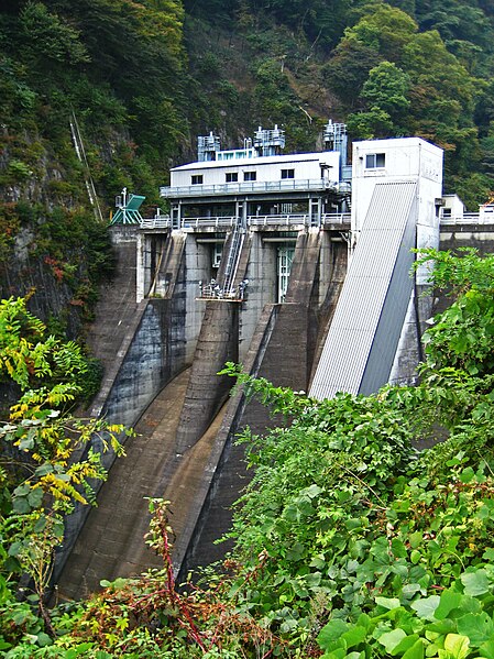
148:Aimata Dam.
136:Description
1003:Aimata Dam
994:File usage
947:Dimensions
748:image/jpeg
733:media type
475:Aimata Dam
80:image/jpeg
27:File usage
1026:سد ايماتا
944:Thumbnail
941:Date/Time
822:data size
635:inception
263:Licensing
145:English:
1071:Q4697126
1056:利根川上流ダム群
973:(918 KB)
837:939,978
767:checksum
435:Captions
375:to remix
369:to share
360:license.
187:)'s file
986:ja:相俣ダム
958:current
953:Comment
704:heading
663:heading
459:depicts
439:English
128:Summary
76:
979:Qurren
911:2,121
874:2,830
859:height
712:degree
667:degree
233:
197:Qurren
192:Author
179:Qurren
175:Source
1046:猿ヶ京温泉
913:pixel
896:width
876:pixel
801:SHA-1
1051:相俣ダム
950:User
839:byte
710:270
417:true
414:true
356:and
313:true
310:true
304:GFDL
202:talk
184:talk
165:Date
157:相俣ダム
153:日本語:
17:File
1061:赤谷川
797::
707::
352:,
348:,
63:|
59:|
55:|
51:|
45:.
299:.
199:(
181:(
159:。
116:.
82:)
67:.
Text is available under the Creative Commons Attribution-ShareAlike License. Additional terms may apply.
