309:
218:
232:
321:
273:
90:
38:
704:
335:
for US works, such as Canada, Mainland China (not Hong Kong or Macao), Germany, Mexico, and
Switzerland. The creator and year of publication are essential information and must be provided. See
209:
721:{{Information |Description={{en|1=Description={{en|1=Original caption: "PLATE VIII. Map showing mines in northern Monroe county." The city is
149:
331:
This image might not be in the public domain outside of the United States; this especially applies in the countries and areas that do not apply the
157:
537:
225:
632:
595:
558:
503:
469:
435:
530:
401:
384:
336:
332:
340:
184:
56:
52:
48:
42:
735:
The following pages on the
English Knowledge (XXG) use this file (pages on other projects are not listed):
101:
714:
161:
69:
109:
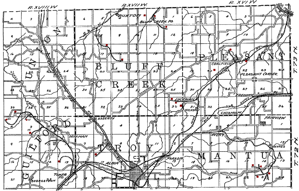
725:. Mines have been tinted red by the uploader. The railroads shown on the map are: CRI&P [
164:. Former coal mining camps include Hiteman, Buxton, Bluff Creek, Lockman, Coalfield and Hynes.
148:. Mines have been tinted red by the uploader. The railroads shown on the map are: CRI&P
298:
153:
144:
Original caption: "PLATE VIII. Map showing mines in northern Monroe county." The city is
297:
occurred prior to
January 1, 1929, and if not then due to lack of notice or renewal. See
285:
231:
293:. This applies to U.S. works where the copyright has expired, often because its first
96:
145:
294:
215:
739:
722:
703:
698:
60:
37:
290:
173:
671:
Click on a date/time to view the file as it appeared at that time.
428:
217:
267:
210:
41° 05′ 21.3″ N, 92° 47′ 34.7″ W
200:
84:
319:
307:
271:
368:
Add a one-line explanation of what this file represents
128:
108:
Commons is a freely licensed media file repository.
74:(1,229 × 784 pixels, file size: 197 KB, MIME type:
757:
89:
8:
673:
364:
247:
185:Iowa Geological Survey Annual Report, 1908
150:en:Chicago, Burlington and Quincy Railroad
750:The following other wikis use this file:
519:fae7812940405ec5149f08fbd5f7773afcc03b1d
183:The Coal Deposits of Iowa, Chapter I of
737:
646:
630:
609:
593:
572:
556:
517:
501:
483:
467:
449:
433:
415:
399:
382:
379:
360:
353:
203:
224:View this and other nearby images on:
308:
272:
7:
158:en:Chicago and North Western Railway
662:
373:
367:
330:
281:
138:
121:
67:
372:
436:coordinates of the point of view
358:
230:
216:
88:
31:
21:
355:
139:
14:
354:
26:
1:
451:41°5'21.300"N, 92°47'34.699"W
337:Knowledge (XXG):Public domain
380:Items portrayed in this file
776:
754:Usage on fr.wikipedia.org
341:Knowledge (XXG):Copyrights
283:This media file is in the
663:
16:
357:
333:rule of the shorter term
301:for further explanation.
95:This is a file from the
720:
190:
179:
172:
169:
162:en:Iowa Central Railway
131:
99:. Information from its
324:
313:
277:
236:41.089250; -92.792972
102:description page there
41:Size of this preview:
699:19:53, 17 August 2009
323:
311:
275:
531:determination method
47:Other resolutions:
325:
314:
278:
154:en:Wabash Railroad
61:1,229 × 784 pixels
57:1,024 × 653 pixels
746:Global file usage
728:
366:
352:
351:
345:
343:for more details.
266:
265:
241:
240:
198:
197:
117:
116:
97:Wikimedia Commons
32:Global file usage
767:
716:Douglas W. Jones
711:
651:
614:
577:
540:
535:
346:
329:
322:
310:
274:
268:
262:
259:
256:
253:
248:
237:
234:
220:
219:
213:
212:
201:
175:
143:
135:
129:
113:
92:
91:
85:
79:
77:
64:
53:640 × 408 pixels
49:320 × 204 pixels
43:800 × 510 pixels
775:
774:
770:
769:
768:
766:
765:
764:
744:
736:
729:
717:
709:
665:
664:
661:
660:
659:
658:
657:
656:
655:
654:
652:
649:
639:
638:
637:
635:
624:
623:
622:
621:
620:
619:
618:
617:
615:
612:
602:
601:
600:
598:
587:
586:
585:
584:
583:
582:
581:
580:
578:
575:
565:
564:
563:
561:
550:
549:
548:
547:
546:
545:
544:
543:
542:
541:
536:
533:
524:
523:
522:
520:
510:
509:
508:
506:
495:
494:
493:
492:
491:
490:
489:
488:
486:
476:
475:
474:
472:
461:
460:
459:
458:
457:
456:
455:
454:
452:
442:
441:
440:
438:
427:
426:
425:
424:
423:
422:
421:
420:
418:
408:
407:
406:
404:
393:
392:
391:
390:
389:
387:
371:
370:
369:
344:
328:
320:
303:
260:
257:
254:
251:
246:
235:
208:
207:
204:Camera location
199:
165:
133:
126:
119:
118:
107:
106:
105:is shown below.
81:
75:
73:
66:
65:
46:
12:
11:
5:
773:
771:
763:
762:
761:
760:
748:
747:
743:
742:
734:
733:
732:
727:
726:
723:en:Albia, Iowa
719:
715:
712:
706:
701:
696:
692:
691:
688:
685:
682:
679:
676:
669:
668:
653:
647:
645:
644:
643:
642:
641:
640:
636:
631:
629:
628:
627:
626:
625:
616:
610:
608:
607:
606:
605:
604:
603:
599:
594:
592:
591:
590:
589:
588:
579:
573:
571:
570:
569:
568:
567:
566:
562:
557:
555:
554:
553:
552:
551:
529:
528:
527:
526:
525:
521:
518:
516:
515:
514:
513:
512:
511:
507:
502:
500:
499:
498:
497:
496:
487:
484:
482:
481:
480:
479:
478:
477:
473:
468:
466:
465:
464:
463:
462:
453:
450:
448:
447:
446:
445:
444:
443:
439:
434:
432:
431:
430:
429:
419:
416:
414:
413:
412:
411:
410:
409:
405:
400:
398:
397:
396:
395:
394:
388:
383:
381:
378:
377:
376:
375:
374:
363:
362:
359:
356:
350:
349:
347:
326:
316:
315:
305:
279:
264:
263:
245:
242:
239:
238:
228:
222:
205:
196:
195:
192:
188:
187:
181:
177:
176:
171:
167:
166:
146:en:Albia, Iowa
136:
134:AlbiaMines.png
127:
125:
122:
120:
115:
114:
93:
83:
82:
40:
36:
35:
34:
29:
24:
19:
13:
10:
9:
6:
4:
3:
2:
772:
759:
756:
755:
753:
752:
751:
745:
741:
738:
730:
724:
718:
713:
707:
705:
702:
700:
697:
694:
693:
689:
686:
683:
680:
677:
675:
674:
672:
666:
634:
597:
560:
539:
532:
505:
471:
437:
403:
386:
348:
342:
338:
334:
327:
318:
317:
312:United States
306:
304:
302:
300:
296:
292:
291:United States
288:
287:
286:public domain
280:
276:Public domain
270:
269:
255:Public domain
252:Public domain
250:
249:
243:
233:
229:
227:
226:OpenStreetMap
223:
221:
211:
206:
202:
193:
189:
186:
182:
178:
168:
163:
159:
156:, CM&StP
155:
151:
147:
142:
137:
130:
123:
111:
104:
103:
98:
94:
87:
86:
80:
71:
70:Original file
62:
58:
54:
50:
44:
39:
33:
30:
28:
25:
23:
20:
18:
15:
749:
708:1,229 × 784
670:
667:File history
284:
282:
140:
110:You can help
100:
68:
22:File history
740:Albia, Iowa
295:publication
194:Henry Hinds
152:, CB&Q
132:Description
731:File usage
684:Dimensions
470:media type
27:File usage
681:Thumbnail
678:Date/Time
559:data size
485:image/png
402:inception
299:this page
244:Licensing
141:English:
76:image/png
710:(197 KB)
574:201,322
504:checksum
361:Captions
695:current
690:Comment
385:depicts
365:English
289:in the
124:Summary
72:
648:1,229
596:height
214:
191:Author
180:Source
160:, and
758:Albia
650:pixel
633:width
613:pixel
538:SHA-1
261:false
258:false
687:User
611:784
576:byte
417:1909
339:and
174:1909
170:Date
17:File
534::
59:|
55:|
51:|
45:.
112:.
78:)
63:.
Text is available under the Creative Commons Attribution-ShareAlike License. Additional terms may apply.
