347:
280:
230:
272:
222:
294:
244:
315:
353:
358:
67:
823:"}},"text\/plain":{"en":{"":"heading"}}},"{\"value\":{\"amount\":\"+202\",\"unit\":\"http:\\\/\\\/www.wikidata.org\\\/entity\\\/Q28390\"},\"type\":\"quantity\"}":{"text\/html":{"en":{"P7787":"202
759:"}},"text\/plain":{"en":{"":"heading"}}},"{\"value\":{\"amount\":\"+202\",\"unit\":\"http:\\\/\\\/www.wikidata.org\\\/entity\\\/Q28390\"},\"type\":\"quantity\"}":{"text\/html":{"en":{"P7787":"202
819:
263:
213:
1142:== {{int:filedesc}} == {{Information |description={{en|1=Alder Hills Nature Reserve 5 hectares of heathland, trees, scrub & lake, managed by Dorset Wildlife Trust http://www.dorsetwildlife.co.uk/alder_hills_reserve. In the background to the right, gasomet
38:
405:– You must give appropriate credit, provide a link to the license, and indicate if changes were made. You may do so in any reasonable manner, but not in any way that suggests the licensor endorses you or your use.
78:
46:
820:
756:
958:
691:
621:
585:
287:
237:
741:
322:
1167:
This file contains additional information, probably added from the digital camera or scanner used to create or digitize it.
1124:
1119:
37:
412:
533:
1053:
1016:
979:
924:
890:
861:
834:
797:
770:
719:
675:
569:
541:
526:
513:
951:
734:
704:
641:
605:
486:
469:
309:
368:
121:
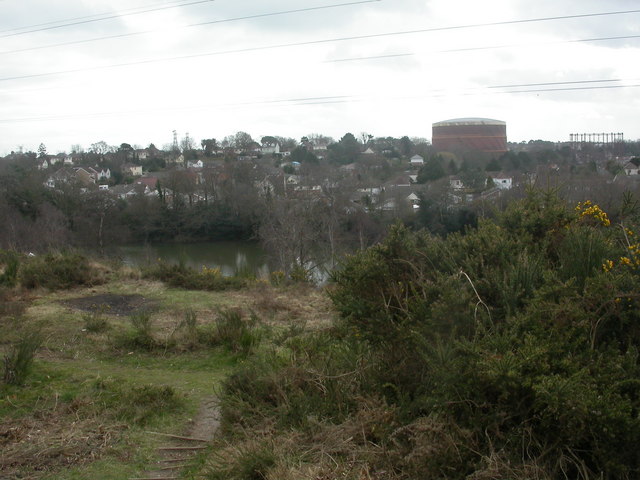
Alder Hills Nature
Reserve 5 hectares of heathland, trees, scrub & lake, managed by Dorset Wildlife Trust
1170:
If the file has been modified from its original state, some details may not fully reflect the modified file.
1152:
The following pages on the
English Knowledge (XXG) use this file (pages on other projects are not listed):
411:– If you remix, transform, or build upon the material, you must distribute your contributions under the
329:
on the
Geograph website for the photographer's contact details. The copyright on this image is owned by
1135:
365:
827:"}},"text\/plain":{"en":{"P7787":"202 degree"}}}}": -->
763:"}},"text\/plain":{"en":{"P7787":"202 degree"}}}}": -->
86:
182:
726:
711:
548:
166:
293:
243:
122:
334:
73:
1156:
134:
277:
227:
155:
145:
314:
326:
125:. In the background to the right, gasometers at Branksome Gas Works.
1092:
Click on a date/time to view the file as it appeared at that time.
279:
229:
254:
204:
61:
264:
50° 44′ 17.3″ N, 1° 54′ 45″ W
214:
50° 44′ 17.3″ N, 1° 54′ 45″ W
111:
Alder Hills Nature
Reserve - geograph.org.uk - 1198354.jpg
47:
Alder_Hills_Nature_Reserve_-_geograph.org.uk_-_1198354.jpg
453:
Add a one-line explanation of what this file represents
105:
85:
Commons is a freely licensed media file repository.
622:
Creative
Commons Attribution-ShareAlike 2.0 Generic
123:
http://www.dorsetwildlife.co.uk/alder_hills_reserve
51:(640 × 480 pixels, file size: 69 KB, MIME type:
422:https://creativecommons.org/licenses/by-sa/2.0
66:
428:Creative Commons Attribution-Share Alike 2.0
346:
8:
824:
760:
388:– to copy, distribute and transmit the work
1172:
1094:
449:
712:https://www.geograph.org.uk/photo/1198354
549:https://www.geograph.org.uk/profile/30470
940:cb0b0348bf977019e0ef60e993d7bcaf21a3e9ad
1174:
1154:
1067:
1051:
1030:
1014:
993:
977:
938:
922:
904:
888:
848:
832:
784:
768:
689:
673:
655:
639:
619:
603:
583:
567:
500:
484:
467:
464:
445:
438:
257:
207:
286:View this and other nearby images on:
236:View this and other nearby images on:
7:
333:and is licensed for reuse under the
1083:
369:Attribution-Share Alike 2.0 Generic
357:
352:
337:Attribution-ShareAlike 2.0 license.
1165:
458:
452:
343:
320:
115:
98:
44:
457:
771:coordinates of the point of view
443:
399:Under the following conditions:
364:This file is licensed under the
356:
351:
345:
313:
292:
278:
270:
242:
228:
220:
65:
21:
440:
116:
41:No higher resolution available.
14:
692:file available on the internet
439:
321:This image was taken from the
26:
1:
835:coordinates of depicted place
31:
742:Geograph Britain and Ireland
527:object of statement has role
465:Items portrayed in this file
269:
219:
850:50°44'17.34"N, 1°54'45.36"W
786:50°44'17.34"N, 1°54'45.36"W
1196:
413:same or compatible license
197:Alder Hills Nature Reserve
178:Alder Hills Nature Reserve
1084:
195:Mike Faherty /
176:Mike Faherty /
16:
720:geograph.org.uk image ID
442:
379:
72:This is a file from the
1141:
1120:23:27, 25 February 2011
167:required by the license
151:
140:
133:
130:
108:
76:. Information from its
327:this photograph's page
298:50.738150; -1.912600
248:50.738150; -1.912600
79:description page there
952:determination method
394:– to adapt the work
514:author name string
1183:
1182:
1145:
826:
762:
606:copyright license
451:
342:
341:
325:collection. See
303:
302:
253:
252:
202:
201:
170:
94:
93:
74:Wikimedia Commons
1187:
1173:
1132:
1072:
1035:
998:
961:
956:
872:
871:
866:
808:
807:
802:
744:
739:
729:
724:
714:
709:
705:described at URL
570:copyright status
551:
546:
536:
531:
521:
518:
435:
432:
429:
426:
423:
415:as the original.
377:
366:Creative Commons
360:
359:
355:
354:
349:
348:
335:Creative Commons
323:Geograph project
317:
310:
299:
296:
282:
281:
275:
274:
273:
267:
266:
255:
249:
246:
232:
231:
225:
224:
223:
217:
216:
205:
164:
136:
120:
112:
106:
90:
69:
68:
62:
56:
54:
1195:
1194:
1190:
1189:
1188:
1186:
1185:
1184:
1161:
1153:
1146:
1138:
1130:
1086:
1085:
1082:
1081:
1080:
1079:
1078:
1077:
1076:
1075:
1073:
1070:
1060:
1059:
1058:
1056:
1045:
1044:
1043:
1042:
1041:
1040:
1039:
1038:
1036:
1033:
1023:
1022:
1021:
1019:
1008:
1007:
1006:
1005:
1004:
1003:
1002:
1001:
999:
996:
986:
985:
984:
982:
971:
970:
969:
968:
967:
966:
965:
964:
963:
962:
957:
954:
945:
944:
943:
941:
931:
930:
929:
927:
916:
915:
914:
913:
912:
911:
910:
909:
907:
897:
896:
895:
893:
882:
881:
880:
879:
878:
877:
876:
875:
874:
873:
869:
867:
864:
855:
854:
853:
851:
841:
840:
839:
837:
818:
817:
816:
815:
814:
813:
812:
811:
810:
809:
805:
803:
800:
791:
790:
789:
787:
777:
776:
775:
773:
754:
753:
752:
751:
750:
749:
748:
747:
746:
745:
740:
737:
731:
730:
725:
722:
716:
715:
710:
707:
698:
697:
696:
694:
682:
681:
680:
678:
667:
666:
665:
664:
663:
662:
661:
660:
658:
648:
647:
646:
644:
633:
632:
631:
630:
629:
628:
627:
626:
624:
612:
611:
610:
608:
597:
596:
595:
594:
593:
592:
591:
590:
588:
576:
575:
574:
572:
561:
560:
559:
558:
557:
556:
555:
554:
553:
552:
547:
544:
538:
537:
532:
529:
523:
522:
519:
516:
507:
506:
505:
503:
493:
492:
491:
489:
478:
477:
476:
475:
474:
472:
456:
455:
454:
437:
436:
433:
430:
427:
424:
421:
420:
378:
375:
372:
361:
338:
308:
297:
271:
262:
261:
258:Object location
247:
221:
212:
211:
208:Camera location
203:
192:
185:
173:
146:geograph.org.uk
126:
110:
103:
96:
95:
84:
83:
82:is shown below.
58:
52:
50:
43:
42:
12:
11:
5:
1193:
1191:
1181:
1180:
1177:
1164:
1160:
1159:
1151:
1150:
1149:
1144:
1143:
1140:
1136:
1133:
1127:
1122:
1117:
1113:
1112:
1109:
1106:
1103:
1100:
1097:
1090:
1089:
1074:
1068:
1066:
1065:
1064:
1063:
1062:
1061:
1057:
1052:
1050:
1049:
1048:
1047:
1046:
1037:
1031:
1029:
1028:
1027:
1026:
1025:
1024:
1020:
1015:
1013:
1012:
1011:
1010:
1009:
1000:
994:
992:
991:
990:
989:
988:
987:
983:
978:
976:
975:
974:
973:
972:
950:
949:
948:
947:
946:
942:
939:
937:
936:
935:
934:
933:
932:
928:
923:
921:
920:
919:
918:
917:
908:
905:
903:
902:
901:
900:
899:
898:
894:
889:
887:
886:
885:
884:
883:
860:
859:
858:
857:
856:
852:
849:
847:
846:
845:
844:
843:
842:
838:
833:
831:
830:
829:
828:
822:
796:
795:
794:
793:
792:
788:
785:
783:
782:
781:
780:
779:
778:
774:
769:
767:
766:
765:
764:
758:
733:
732:
718:
717:
703:
702:
701:
700:
699:
695:
690:
688:
687:
686:
685:
684:
683:
679:
676:source of file
674:
672:
671:
670:
669:
668:
659:
656:
654:
653:
652:
651:
650:
649:
645:
640:
638:
637:
636:
635:
634:
625:
620:
618:
617:
616:
615:
614:
613:
609:
604:
602:
601:
600:
599:
598:
589:
584:
582:
581:
580:
579:
578:
577:
573:
568:
566:
565:
564:
563:
562:
540:
539:
525:
524:
512:
511:
510:
509:
508:
504:
501:
499:
498:
497:
496:
495:
494:
490:
485:
483:
482:
481:
480:
479:
473:
468:
466:
463:
462:
461:
460:
459:
448:
447:
444:
441:
419:
418:
417:
416:
406:
397:
396:
395:
389:
382:You are free:
373:
363:
362:
344:
340:
339:
318:
307:
304:
301:
300:
290:
284:
259:
251:
250:
240:
234:
209:
200:
199:
193:
190:
187:
186:
181:
174:
171:
159:
158:
153:
149:
148:
142:
138:
137:
132:
128:
127:
113:
104:
102:
99:
97:
92:
91:
70:
60:
59:
40:
36:
35:
34:
29:
24:
19:
13:
10:
9:
6:
4:
3:
2:
1192:
1178:
1175:
1171:
1168:
1162:
1158:
1155:
1147:
1139:
1134:
1128:
1126:
1123:
1121:
1118:
1115:
1114:
1110:
1107:
1104:
1101:
1098:
1096:
1095:
1093:
1087:
1055:
1018:
981:
960:
953:
926:
892:
863:
836:
799:
772:
743:
736:
728:
721:
713:
706:
693:
677:
657:10 March 2009
643:
623:
607:
587:
571:
550:
543:
535:
528:
515:
488:
471:
425:CC BY-SA 2.0
414:
410:
407:
404:
401:
400:
398:
393:
390:
387:
384:
383:
381:
380:
374:Attribution:
370:
367:
350:
336:
332:
328:
324:
319:
316:
312:
311:
305:
295:
291:
289:
288:OpenStreetMap
285:
283:
265:
260:
256:
245:
241:
239:
238:OpenStreetMap
235:
233:
215:
210:
206:
198:
194:
189:
188:
184:
180: /
179:
175:
168:
163:
161:
160:
157:
154:
150:
147:
143:
139:
135:10 March 2009
129:
124:
119:
114:
107:
100:
88:
81:
80:
75:
71:
64:
63:
57:
48:
39:
33:
30:
28:
25:
23:
20:
18:
15:
1169:
1166:
1091:
1088:File history
534:photographer
520:Mike Faherty
408:
402:
391:
385:
376:Mike Faherty
331:Mike Faherty
330:
268:
218:
196:
183:CC BY-SA 2.0
177:
156:Mike Faherty
117:
87:You can help
77:
45:
22:File history
1157:Alder Hills
1137:GeographBot
586:copyrighted
409:share alike
403:attribution
162:Attribution
109:Description
1176:_error
1148:File usage
1129:640 × 480
1105:Dimensions
906:image/jpeg
891:media type
502:some value
53:image/jpeg
27:File usage
1102:Thumbnail
1099:Date/Time
980:data size
642:inception
306:Licensing
191:InfoField
172:InfoField
118:English:
1163:Metadata
925:checksum
735:operator
446:Captions
392:to remix
386:to share
371:license.
32:Metadata
1131:(69 KB)
1116:current
1111:Comment
995:70,724
862:heading
821:heading
798:heading
757:heading
727:1198354
487:creator
470:depicts
450:English
101:Summary
49:
1017:height
870:degree
825:degree
806:degree
761:degree
276:
226:
152:Author
141:Source
1071:pixel
1054:width
1034:pixel
959:SHA-1
144:From
1108:User
1069:640
1032:480
997:byte
868:202
804:202
434:true
431:true
131:Date
17:File
542:URL
955::
865::
801::
738::
723::
708::
545::
530::
517::
1179:0
169:)
165:(
89:.
55:)
Text is available under the Creative Commons Attribution-ShareAlike License. Additional terms may apply.
_heading:202.00&language=en)
_heading:202.00&language=en)
