252:
275:
281:
286:
86:
38:
1042:
883:
900:{{Information |Description={{de|1=Physische Positionskarte von {{w|Aruba|3=de}} {{w|Mercator-Projektion|3=de}}. Geographische Begrenzung der Karte: * N: 12.65° N * S: 12.38° N * W: 70.11° W * O: 69.83° W}} {{en|1=Physical location map of {{w|Aruba...
327:– You must give appropriate credit, provide a link to the license, and indicate if changes were made. You may do so in any reasonable manner, but not in any way that suggests the licensor endorses you or your use.
1336:
1002:
1307:
919:
1232:
52:
48:
42:
97:
974:
65:
716:
628:
558:
522:
1057:
969:
334:
442:
959:
811:
774:
737:
682:
648:
612:
506:
478:
463:
450:
435:
709:
578:
542:
408:
391:
218:
251:
470:
296:
944:
964:
333:– If you remix, transform, or build upon the material, you must distribute your contributions under the
939:
914:
293:
1017:
929:
1052:
1122:
893:
949:
105:
1012:
882:
877:
145:
56:
37:
485:
954:
1257:
1032:
92:
1317:
992:
1267:
1207:
934:
1067:
200:
1242:
237:
222:
1327:
1162:
1202:
1102:
1077:
1117:
924:
1087:
172:
850:
Click on a date/time to view the file as it appeared at that time.
141:
1277:
1192:
1222:
1197:
1182:
1132:
1297:
1247:
1142:
80:
1292:
1217:
1172:
1137:
1287:
1272:
1152:
1027:
1157:
1147:
375:
Add a one-line explanation of what this file represents
1212:
1187:
1282:
1127:
1123:
Knowledge:Kartenwerkstatt/Positionskarten/Nordamerika
1112:
1092:
559:
Creative
Commons Attribution-ShareAlike 3.0 Unported
124:
104:
Commons is a freely licensed media file repository.
1177:
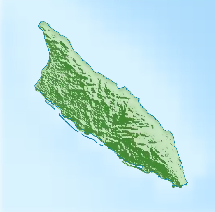
176:Mercator projection. Geographic limits of the map:
70:(888 × 878 pixels, file size: 161 KB, MIME type:
1043:Шаблён:Лякалізацыйная мапа Нідэрляндаў (Аруба)
344:https://creativecommons.org/licenses/by-sa/3.0
85:
350:Creative Commons Attribution-Share Alike 3.0
274:
8:
1018:Módulu:Mapa de llocalización/datos/Aruba/usu
310:– to copy, distribute and transmit the work
852:
371:
985:The following other wikis use this file:
920:Beth Israel Synagogue (Oranjestad, Aruba)
486:http://commons.wikimedia.org/User:Carport
1013:Módulu:Mapa de llocalización/datos/Aruba
698:c913360cda3447e8c21ad2a11aca463e1de76f83
1318:Bandar Udara Internasional Ratu Beatrix
1258:Plantilla:Mapa de localización de Aruba
993:Koningin Beatrix Internasionale Lughawe
912:
825:
809:
788:
772:
751:
735:
696:
680:
662:
646:
626:
610:
592:
576:
556:
540:
520:
504:
422:
406:
389:
386:
367:
360:
247:
910:The following 13 pages use this file:
148:. Geographische Begrenzung der Karte:
7:
297:Attribution-Share Alike 3.0 Unported
841:
285:
280:
1208:Modul:Location map data nl-aw/Doku
975:Module:Location map/data/Aruba/doc
380:
374:
271:
165:
134:
117:
63:
1039:Usage on be-tarask.wikipedia.org
379:
365:
321:Under the following conditions:
292:This file is licensed under the
284:
279:
273:
250:
84:
31:
21:
1163:Kategorie:Rennstrecke auf Aruba
362:
219:File:Aruba location map (2).svg
166:
14:
1328:Modulo:Location map data nl-aw
970:Module:Location map/data/Aruba
361:
135:
26:
1:
1203:Modul:Location map data nl-aw
1103:Skabelon:Kortpositioner Aruba
1068:Šablon:Lokacijska karta Aruba
629:original creation by uploader
257:Equivalent administrative map
140:Physische Positionskarte von
130:Aruba relief location map.jpg
1268:Modèle:Géolocalisation/Aruba
1243:Ŝablono:Situo sur mapo Arubo
1233:Πρότυπο:Location map Αρούμπα
1118:Vorlage:Positionskarte Aruba
1078:Plantilya:Location map Aruba
960:San Nicolas Bay Reef Islands
436:object of statement has role
387:Items portrayed in this file
1324:Usage on it.wikivoyage.org
1169:Usage on de.wikivoyage.org
1074:Usage on ceb.wikipedia.org
1009:Usage on ast.wikipedia.org
1353:
1314:Usage on id.wikipedia.org
1304:Usage on he.wikipedia.org
1264:Usage on fr.wikipedia.org
1254:Usage on es.wikipedia.org
1239:Usage on eo.wikipedia.org
1229:Usage on el.wikipedia.org
1109:Usage on de.wikipedia.org
1099:Usage on da.wikipedia.org
1084:Usage on cs.wikipedia.org
1064:Usage on bs.wikipedia.org
1049:Usage on bg.wikipedia.org
1024:Usage on az.wikipedia.org
999:Usage on ar.wikipedia.org
989:Usage on af.wikipedia.org
335:same or compatible license
227:STRM-3 data for the relief
1033:Şablon:Yer xəritəsi Aruba
842:
211:
171:Physical location map of
16:
364:
301:
91:This is a file from the
945:Oranjestad Reef Islands
899:
878:15:17, 30 November 2012
243:
233:
206:
199:
196:
127:
95:. Information from its
1003:قالب:خريطة مواقع أروبا
98:description page there
41:Size of this preview:
1308:תבנית:מפת מיקום/ארובה
965:Tierra del Sol Salina
930:Frenchman's Pass
1278:Grottes de Quadiriki
1088:Šablona:LocMap Aruba
940:Natural Pool (Aruba)
915:Aruba Natural Bridge
710:determination method
1293:Plage d'Arashi
1193:San Nicolas (Aruba)
1133:Palm Island (Aruba)
316:– to adapt the work
146:Mercator-Projektion
47:Other resolutions:
1298:Santa Cruz (Aruba)
1248:Nacia parko Arikok
1223:Palm Beach (Aruba)
1198:Santa Cruz (Aruba)
1183:Oranjestad (Aruba)
1143:Renaissance Island
950:Palm Island, Aruba
464:Wikimedia username
451:author name string
1337:more global usage
981:Global file usage
903:
543:copyright license
373:
264:
263:
113:
112:
93:Wikimedia Commons
32:Global file usage
1344:
890:
830:
793:
756:
719:
714:
594:30 November 2012
507:copyright status
488:
483:
473:
468:
458:
455:
445:
440:
357:
354:
351:
348:
345:
337:as the original.
294:Creative Commons
288:
287:
283:
282:
277:
276:
254:
213:
202:
201:30 November 2012
170:
139:
131:
125:
109:
88:
87:
81:
75:
73:
60:
57:888 × 878 pixels
53:485 × 480 pixels
49:243 × 240 pixels
43:606 × 599 pixels
1352:
1351:
1347:
1346:
1345:
1343:
1342:
1341:
1058:Шаблон:ПК Аруба
979:
955:Quadiriki Caves
904:
896:
888:
844:
843:
840:
839:
838:
837:
836:
835:
834:
833:
831:
828:
818:
817:
816:
814:
803:
802:
801:
800:
799:
798:
797:
796:
794:
791:
781:
780:
779:
777:
766:
765:
764:
763:
762:
761:
760:
759:
757:
754:
744:
743:
742:
740:
729:
728:
727:
726:
725:
724:
723:
722:
721:
720:
715:
712:
703:
702:
701:
699:
689:
688:
687:
685:
674:
673:
672:
671:
670:
669:
668:
667:
665:
655:
654:
653:
651:
640:
639:
638:
637:
636:
635:
634:
633:
631:
619:
618:
617:
615:
604:
603:
602:
601:
600:
599:
598:
597:
595:
585:
584:
583:
581:
570:
569:
568:
567:
566:
565:
564:
563:
561:
549:
548:
547:
545:
534:
533:
532:
531:
530:
529:
528:
527:
525:
513:
512:
511:
509:
498:
497:
496:
495:
494:
493:
492:
491:
490:
489:
484:
481:
475:
474:
469:
466:
460:
459:
456:
453:
447:
446:
441:
438:
429:
428:
427:
425:
415:
414:
413:
411:
400:
399:
398:
397:
396:
394:
378:
377:
376:
359:
358:
355:
352:
349:
346:
343:
342:
300:
289:
270:
265:
258:
255:
192:
164:
129:
122:
115:
114:
103:
102:
101:is shown below.
77:
71:
69:
62:
61:
46:
12:
11:
5:
1350:
1348:
1339:of this file.
1333:
1332:
1331:
1330:
1322:
1321:
1320:
1312:
1311:
1310:
1302:
1301:
1300:
1295:
1290:
1285:
1280:
1275:
1270:
1262:
1261:
1260:
1252:
1251:
1250:
1245:
1237:
1236:
1235:
1227:
1226:
1225:
1220:
1218:Tanki Leendert
1215:
1210:
1205:
1200:
1195:
1190:
1185:
1180:
1175:
1173:Manchebo Beach
1167:
1166:
1165:
1160:
1155:
1150:
1145:
1140:
1138:Spanish Lagoon
1135:
1130:
1125:
1120:
1115:
1107:
1106:
1105:
1097:
1096:
1095:
1090:
1082:
1081:
1080:
1072:
1071:
1070:
1062:
1061:
1060:
1055:
1047:
1046:
1045:
1037:
1036:
1035:
1030:
1022:
1021:
1020:
1015:
1007:
1006:
1005:
997:
996:
995:
983:
982:
978:
977:
972:
967:
962:
957:
952:
947:
942:
937:
932:
927:
922:
917:
908:
907:
902:
901:
898:
894:
891:
885:
880:
875:
871:
870:
867:
864:
861:
858:
855:
848:
847:
832:
826:
824:
823:
822:
821:
820:
819:
815:
810:
808:
807:
806:
805:
804:
795:
789:
787:
786:
785:
784:
783:
782:
778:
773:
771:
770:
769:
768:
767:
758:
752:
750:
749:
748:
747:
746:
745:
741:
736:
734:
733:
732:
731:
730:
708:
707:
706:
705:
704:
700:
697:
695:
694:
693:
692:
691:
690:
686:
681:
679:
678:
677:
676:
675:
666:
663:
661:
660:
659:
658:
657:
656:
652:
647:
645:
644:
643:
642:
641:
632:
627:
625:
624:
623:
622:
621:
620:
616:
613:source of file
611:
609:
608:
607:
606:
605:
596:
593:
591:
590:
589:
588:
587:
586:
582:
577:
575:
574:
573:
572:
571:
562:
557:
555:
554:
553:
552:
551:
550:
546:
541:
539:
538:
537:
536:
535:
526:
521:
519:
518:
517:
516:
515:
514:
510:
505:
503:
502:
501:
500:
499:
477:
476:
462:
461:
449:
448:
434:
433:
432:
431:
430:
426:
423:
421:
420:
419:
418:
417:
416:
412:
407:
405:
404:
403:
402:
401:
395:
390:
388:
385:
384:
383:
382:
381:
370:
369:
366:
363:
341:
340:
339:
338:
328:
319:
318:
317:
311:
304:You are free:
291:
290:
272:
269:
266:
262:
261:
260:
259:
256:
249:
245:
244:Other versions
241:
240:
235:
231:
230:
229:
228:
225:
208:
204:
203:
198:
194:
193:
191:
190:
187:
184:
181:
163:
162:
159:
156:
153:
132:
123:
121:
118:
116:
111:
110:
89:
79:
78:
40:
36:
35:
34:
29:
24:
19:
13:
10:
9:
6:
4:
3:
2:
1349:
1340:
1338:
1329:
1326:
1325:
1323:
1319:
1316:
1315:
1313:
1309:
1306:
1305:
1303:
1299:
1296:
1294:
1291:
1289:
1288:Noord (Aruba)
1286:
1284:
1281:
1279:
1276:
1274:
1273:Mont Jamanota
1271:
1269:
1266:
1265:
1263:
1259:
1256:
1255:
1253:
1249:
1246:
1244:
1241:
1240:
1238:
1234:
1231:
1230:
1228:
1224:
1221:
1219:
1216:
1214:
1211:
1209:
1206:
1204:
1201:
1199:
1196:
1194:
1191:
1189:
1186:
1184:
1181:
1179:
1176:
1174:
1171:
1170:
1168:
1164:
1161:
1159:
1156:
1154:
1153:Daimari Beach
1151:
1149:
1146:
1144:
1141:
1139:
1136:
1134:
1131:
1129:
1126:
1124:
1121:
1119:
1116:
1114:
1111:
1110:
1108:
1104:
1101:
1100:
1098:
1094:
1091:
1089:
1086:
1085:
1083:
1079:
1076:
1075:
1073:
1069:
1066:
1065:
1063:
1059:
1056:
1054:
1051:
1050:
1048:
1044:
1041:
1040:
1038:
1034:
1031:
1029:
1026:
1025:
1023:
1019:
1016:
1014:
1011:
1010:
1008:
1004:
1001:
1000:
998:
994:
991:
990:
988:
987:
986:
980:
976:
973:
971:
968:
966:
963:
961:
958:
956:
953:
951:
948:
946:
943:
941:
938:
936:
933:
931:
928:
926:
923:
921:
918:
916:
913:
911:
905:
897:
892:
886:
884:
881:
879:
876:
873:
872:
868:
865:
862:
859:
856:
854:
853:
851:
845:
813:
776:
739:
718:
711:
684:
650:
630:
614:
580:
560:
544:
524:
508:
487:
480:
472:
465:
452:
444:
437:
410:
393:
347:CC BY-SA 3.0
336:
332:
329:
326:
323:
322:
320:
315:
312:
309:
306:
305:
303:
302:
298:
295:
278:
267:
253:
248:
246:
242:
239:
236:
232:
226:
224:
220:
217:
216:
215:
209:
205:
195:
188:
185:
182:
179:
178:
177:
174:
169:
160:
157:
154:
151:
150:
149:
147:
143:
138:
133:
126:
119:
107:
100:
99:
94:
90:
83:
82:
76:
67:
66:Original file
58:
54:
50:
44:
39:
33:
30:
28:
25:
23:
20:
18:
15:
1334:
984:
909:
849:
846:File history
443:photographer
330:
324:
313:
307:
210:
175:
167:
144:
136:
106:You can help
96:
64:
22:File history
1028:Palm-Aylend
935:Indiaanskop
523:copyrighted
331:share alike
325:attribution
189:O: 69.83° W
186:W: 70.11° W
183:S: 12.38° N
180:N: 12.65° N
161:O: 69.83° W
158:W: 70.11° W
155:S: 12.38° N
152:N: 12.65° N
128:Description
1158:Baby Beach
1148:Boca Prins
906:File usage
887:888 × 878
863:Dimensions
664:image/jpeg
649:media type
424:some value
72:image/jpeg
27:File usage
1053:Оранестад
860:Thumbnail
857:Date/Time
738:data size
579:inception
268:Licensing
168:English:
137:Deutsch:
1283:Paradera
1213:Savaneta
1188:Paradera
1128:Hooiberg
1113:Jamanota
1093:Jamanota
889:(161 KB)
753:164,397
683:checksum
368:Captions
314:to remix
308:to share
299:license.
214:, using
212:Own work
925:Daimari
895:Carport
874:current
869:Comment
471:Carport
457:Carport
409:creator
392:depicts
372:English
238:Carport
223:Carport
120:Summary
68:
775:height
234:Author
207:Source
1335:View
1178:Noord
829:pixel
812:width
792:pixel
717:SHA-1
173:Aruba
142:Aruba
866:User
827:888
790:878
755:byte
356:true
353:true
197:Date
17:File
479:URL
221:by
713::
482::
467::
454::
439::
55:|
51:|
45:.
108:.
74:)
59:.
Text is available under the Creative Commons Attribution-ShareAlike License. Additional terms may apply.
.svg)