43:
404:
337:
287:
329:
279:
351:
301:
372:
410:
415:
103:
916:"}},"text\/plain":{"en":{"":"heading"}}},"{\"value\":{\"amount\":\"+225\",\"unit\":\"http:\\\/\\\/www.wikidata.org\\\/entity\\\/Q28390\"},\"type\":\"quantity\"}":{"text\/html":{"en":{"P7787":"225
852:"}},"text\/plain":{"en":{"":"heading"}}},"{\"value\":{\"amount\":\"+225\",\"unit\":\"http:\\\/\\\/www.wikidata.org\\\/entity\\\/Q28390\"},\"type\":\"quantity\"}":{"text\/html":{"en":{"P7787":"225
848:
320:
270:
462:– You must give appropriate credit, provide a link to the license, and indicate if changes were made. You may do so in any reasonable manner, but not in any way that suggests the licensor endorses you or your use.
69:
65:
61:
57:
53:
47:
114:
82:
913:
849:
1253:
1469:
1263:
207:
1051:
714:
678:
642:
344:
294:
734:
1500:
379:
1339:
This file contains additional information, probably added from the digital camera or scanner used to create or digitize it.
469:
1228:
835:
605:
1146:
1109:
1072:
1017:
983:
954:
927:
890:
863:
819:
757:
698:
626:
598:
585:
570:
1044:
785:
742:
727:
662:
543:
526:
1217:
1212:
73:
42:
366:
1301:
425:
1342:
If the file has been modified from its original state, some details may not fully reflect the modified file.
1361:
1558:
468:– If you remix, transform, or build upon the material, you must distribute your contributions under the
386:
on the
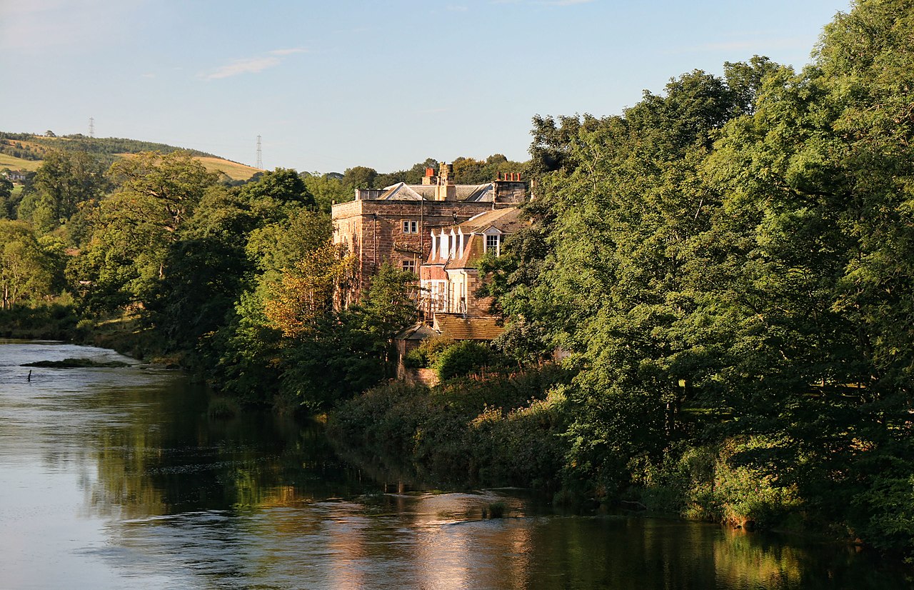
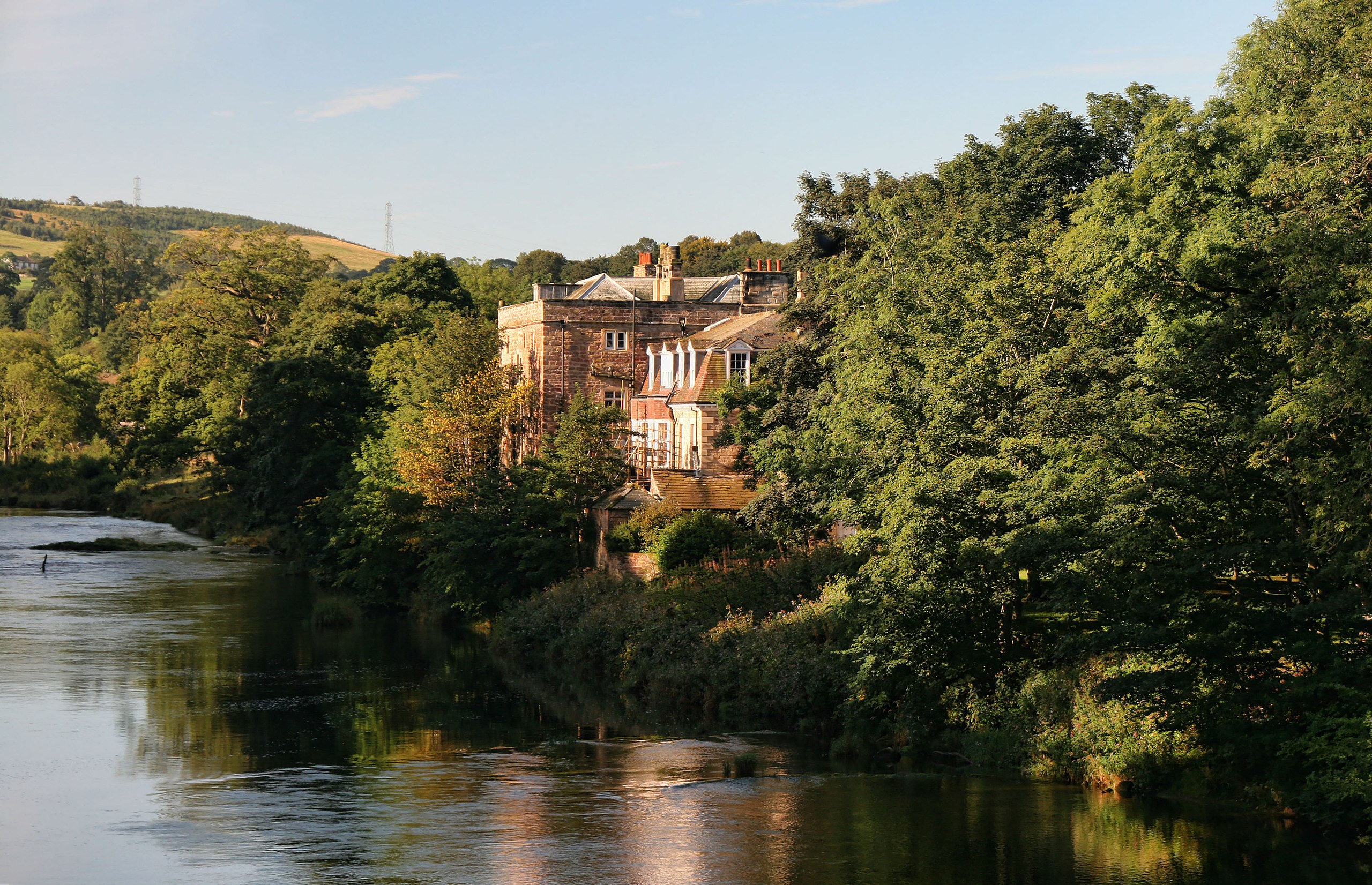
Geograph website for the photographer's contact details. The copyright on this image is owned by
422:
920:"}},"text\/plain":{"en":{"P7787":"225 degree"}}}}": -->
856:"}},"text\/plain":{"en":{"P7787":"225 degree"}}}}": -->
1578:
1248:
157:
Armathwaite Castle. View from
Armathwaite Bridge looking up the River Eden to Armathwaite Castle.
122:
239:
764:
749:
577:
223:
1351:
1258:
350:
300:
1646:
1568:
1540:
1368:
391:
109:
1408:
181:
284:
1596:
166:
1388:
334:
196:
177:
1378:
371:
383:
1185:
Click on a date/time to view the file as it appeared at that time.
1281:
336:
286:
1316:
1306:
1291:
271:
54° 48′ 24.29″ N, 2° 46′ 05.66″ W
185:
311:
261:
97:
321:
54° 48′ 19.1″ N, 2° 46′ 13″ W
1302:
Liste von Burgen und Schlössern im
Vereinigten Königreich
510:
Add a one-line explanation of what this file represents
87:(3,853 × 2,486 pixels, file size: 1.69 MB, MIME type:
1326:
214:
Creative
Commons Attribution Share-alike license 2.0
141:
121:
Commons is a freely licensed media file repository.
679:
Creative
Commons Attribution-ShareAlike 2.0 Generic
147:Armathwaite Castle - geograph.org.uk - 2708747.jpg
1583:Flash did not fire, compulsory flash suppression
479:https://creativecommons.org/licenses/by-sa/2.0
102:
485:Creative Commons Attribution-Share Alike 2.0
403:
8:
1254:Grade II* listed buildings in Eden District
917:
853:
445:– to copy, distribute and transmit the work
1344:
1187:
506:
1274:The following other wikis use this file:
750:https://www.geograph.org.uk/photo/2708747
578:https://www.geograph.org.uk/profile/14194
1033:d2ba55d1cc5b86ee8d76a73a6cde823c8462313c
1726:
1718:
1710:
1702:
1694:
1686:
1678:
1670:
1662:
1654:
1644:
1636:
1628:
1620:
1612:
1604:
1594:
1586:
1576:
1566:
1556:
1548:
1538:
1517:
1509:
1498:
1490:
1482:
1474:
1464:
1456:
1448:
1440:
1432:
1424:
1416:
1405:
1397:
1386:
1376:
1366:
1356:
1246:
1160:
1144:
1123:
1107:
1086:
1070:
1031:
1015:
997:
981:
941:
925:
877:
861:
833:
817:
799:
783:
712:
696:
676:
660:
640:
624:
557:
541:
524:
521:
502:
495:
314:
264:
343:View this and other nearby images on:
293:View this and other nearby images on:
1346:
1244:The following 4 pages use this file:
7:
1470:Adobe Photoshop Elements 6.0 Windows
390:and is licensed for reuse under the
1264:Listed buildings in Hesket, Cumbria
1176:
426:Attribution-Share Alike 2.0 Generic
414:
409:
394:Attribution-ShareAlike 2.0 license.
1337:
515:
509:
400:
377:
151:
134:
80:
514:
1399:Date and time of data generation
864:coordinates of the point of view
500:
456:Under the following conditions:
421:This file is licensed under the
413:
408:
402:
370:
349:
335:
327:
299:
285:
277:
101:
31:
21:
1728:Date metadata was last modified
1230:File Upload Bot (Magnus Manske)
497:
152:
14:
715:file available on the internet
496:
378:This image was taken from the
26:
1:
1437:43.125 meters above sea level
928:coordinates of depicted place
36:
879:54°48'24.289"N, 2°46'5.660"W
735:Geograph Britain and Ireland
599:object of statement has role
522:Items portrayed in this file
326:
276:
252:Peter McDermott /
233:Peter McDermott /
1622:Focal plane resolution unit
1511:Date and time of digitizing
1278:Usage on ceb.wikipedia.org
943:54°48'19.08"N, 2°46'13.44"W
1748:
1696:Supported Flashpix version
1588:Supported Flashpix version
1323:Usage on www.wikidata.org
1313:Usage on sv.wikipedia.org
1298:Usage on de.wikipedia.org
1288:Usage on da.wikipedia.org
470:same or compatible license
1672:Geodetic survey data used
1519:Meaning of each component
1476:File change date and time
1177:
16:
1614:Focal plane Y resolution
1606:Focal plane X resolution
758:geograph.org.uk image ID
499:
436:
108:This is a file from the
1731:22:32, 8 September 2011
1664:GPS time (atomic clock)
1630:Custom image processing
1514:09:27, 4 September 2011
1479:21:32, 8 September 2011
1402:09:27, 4 September 2011
1234:
224:required by the license
202:
192:
172:
165:
162:
144:
112:. Information from its
1362:Canon EOS 400D DIGITAL
384:this photograph's page
355:54.805300; -2.770400
305:54.806747; -2.768239
115:description page there
46:Size of this preview:
1450:Horizontal resolution
1213:19:08, 22 March 2012
1045:determination method
186:geograph_org2commons
74:3,853 × 2,486 pixels
70:2,560 × 1,652 pixels
1484:Y and C positioning
1458:Vertical resolution
1348:Camera manufacturer
451:– to adapt the work
52:Other resolutions:
1720:Compression scheme
1656:Scene capture type
1651:Auto white balance
1317:Armathwaite Castle
1307:Armathwaite Castle
1292:Armathwaite Castle
1282:Armathwaite Castle
1249:Armathwaite Castle
586:author name string
254:Armathwaite Castle
235:Armathwaite Castle
66:1,280 × 826 pixels
62:1,024 × 661 pixels
1735:
1734:
1270:Global file usage
1237:
919:
855:
663:copyright license
508:
399:
398:
382:collection. See
360:
359:
310:
309:
259:
258:
227:
211:
208:Reusing this file
180:; transferred by
130:
129:
110:Wikimedia Commons
32:Global file usage
1739:
1683:4 September 2011
1617:4,453.6082474227
1609:4,433.2953249715
1492:Exposure Program
1421:54° 48′ 24.31″ N
1373:1/100 sec (0.01)
1345:
1225:
1165:
1128:
1091:
1054:
1049:
965:
964:
959:
901:
900:
895:
801:4 September 2011
767:
762:
752:
747:
743:described at URL
737:
732:
627:copyright status
608:
603:
593:
590:
580:
575:
492:
489:
486:
483:
480:
472:as the original.
434:
423:Creative Commons
417:
416:
412:
411:
406:
405:
392:Creative Commons
380:Geograph project
374:
367:
356:
353:
339:
338:
332:
331:
330:
324:
323:
312:
306:
303:
289:
288:
282:
281:
280:
274:
273:
262:
221:
205:
168:
167:4 September 2011
156:
148:
142:
126:
105:
104:
98:
92:
90:
77:
58:640 × 413 pixels
54:320 × 206 pixels
48:800 × 516 pixels
1747:
1746:
1742:
1741:
1740:
1738:
1737:
1736:
1688:GPS tag version
1553:4.9708557128906
1545:6.6438598632812
1333:
1268:
1259:Hesket, Cumbria
1238:
1231:
1223:
1179:
1178:
1175:
1174:
1173:
1172:
1171:
1170:
1169:
1168:
1166:
1163:
1153:
1152:
1151:
1149:
1138:
1137:
1136:
1135:
1134:
1133:
1132:
1131:
1129:
1126:
1116:
1115:
1114:
1112:
1101:
1100:
1099:
1098:
1097:
1096:
1095:
1094:
1092:
1089:
1079:
1078:
1077:
1075:
1064:
1063:
1062:
1061:
1060:
1059:
1058:
1057:
1056:
1055:
1050:
1047:
1038:
1037:
1036:
1034:
1024:
1023:
1022:
1020:
1009:
1008:
1007:
1006:
1005:
1004:
1003:
1002:
1000:
990:
989:
988:
986:
975:
974:
973:
972:
971:
970:
969:
968:
967:
966:
962:
960:
957:
948:
947:
946:
944:
934:
933:
932:
930:
911:
910:
909:
908:
907:
906:
905:
904:
903:
902:
898:
896:
893:
884:
883:
882:
880:
870:
869:
868:
866:
847:
846:
845:
844:
843:
842:
841:
840:
838:
826:
825:
824:
822:
811:
810:
809:
808:
807:
806:
805:
804:
802:
792:
791:
790:
788:
777:
776:
775:
774:
773:
772:
771:
770:
769:
768:
763:
760:
754:
753:
748:
745:
739:
738:
733:
730:
721:
720:
719:
717:
705:
704:
703:
701:
690:
689:
688:
687:
686:
685:
684:
683:
681:
669:
668:
667:
665:
654:
653:
652:
651:
650:
649:
648:
647:
645:
633:
632:
631:
629:
618:
617:
616:
615:
614:
613:
612:
611:
610:
609:
604:
601:
595:
594:
592:Peter McDermott
591:
588:
582:
581:
576:
573:
564:
563:
562:
560:
550:
549:
548:
546:
535:
534:
533:
532:
531:
529:
513:
512:
511:
494:
493:
490:
487:
484:
481:
478:
477:
435:
433:Peter McDermott
432:
429:
418:
395:
388:Peter McDermott
365:
354:
328:
319:
318:
315:Object location
304:
278:
269:
268:
265:Camera location
260:
249:
242:
230:
197:Peter McDermott
182:User:France3470
178:geograph.org.uk
158:
146:
139:
132:
131:
120:
119:
118:is shown below.
94:
88:
86:
79:
78:
51:
12:
11:
5:
1745:
1743:
1733:
1732:
1729:
1725:
1724:
1721:
1717:
1716:
1713:
1709:
1708:
1705:
1701:
1700:
1697:
1693:
1692:
1689:
1685:
1684:
1681:
1677:
1676:
1673:
1669:
1668:
1665:
1661:
1660:
1657:
1653:
1652:
1649:
1643:
1642:
1639:
1635:
1634:
1633:Normal process
1631:
1627:
1626:
1623:
1619:
1618:
1615:
1611:
1610:
1607:
1603:
1602:
1599:
1593:
1592:
1589:
1585:
1584:
1581:
1575:
1574:
1571:
1565:
1564:
1561:
1555:
1554:
1551:
1547:
1546:
1543:
1537:
1536:
1535:
1534:
1533:does not exist
1531:
1528:
1525:
1520:
1516:
1515:
1512:
1508:
1507:
1504:
1497:
1496:
1495:Normal program
1493:
1489:
1488:
1485:
1481:
1480:
1477:
1473:
1472:
1467:
1463:
1462:
1459:
1455:
1454:
1451:
1447:
1446:
1443:
1439:
1438:
1435:
1431:
1430:
1429:2° 46′ 5.62″ W
1427:
1423:
1422:
1419:
1415:
1414:
1411:
1404:
1403:
1400:
1396:
1395:
1392:
1385:
1384:
1381:
1375:
1374:
1371:
1365:
1364:
1359:
1355:
1354:
1349:
1336:
1332:
1331:
1330:
1329:
1321:
1320:
1319:
1311:
1310:
1309:
1304:
1296:
1295:
1294:
1286:
1285:
1284:
1272:
1271:
1267:
1266:
1261:
1256:
1251:
1242:
1241:
1236:
1235:
1233:
1229:
1226:
1222:3,853 × 2,486
1220:
1215:
1210:
1206:
1205:
1202:
1199:
1196:
1193:
1190:
1183:
1182:
1167:
1161:
1159:
1158:
1157:
1156:
1155:
1154:
1150:
1145:
1143:
1142:
1141:
1140:
1139:
1130:
1124:
1122:
1121:
1120:
1119:
1118:
1117:
1113:
1108:
1106:
1105:
1104:
1103:
1102:
1093:
1087:
1085:
1084:
1083:
1082:
1081:
1080:
1076:
1071:
1069:
1068:
1067:
1066:
1065:
1043:
1042:
1041:
1040:
1039:
1035:
1032:
1030:
1029:
1028:
1027:
1026:
1025:
1021:
1016:
1014:
1013:
1012:
1011:
1010:
1001:
998:
996:
995:
994:
993:
992:
991:
987:
982:
980:
979:
978:
977:
976:
953:
952:
951:
950:
949:
945:
942:
940:
939:
938:
937:
936:
935:
931:
926:
924:
923:
922:
921:
915:
889:
888:
887:
886:
885:
881:
878:
876:
875:
874:
873:
872:
871:
867:
862:
860:
859:
858:
857:
851:
839:
836:Canon EOS 400D
834:
832:
831:
830:
829:
828:
827:
823:
818:
816:
815:
814:
813:
812:
803:
800:
798:
797:
796:
795:
794:
793:
789:
784:
782:
781:
780:
779:
778:
756:
755:
741:
740:
726:
725:
724:
723:
722:
718:
713:
711:
710:
709:
708:
707:
706:
702:
699:source of file
697:
695:
694:
693:
692:
691:
682:
677:
675:
674:
673:
672:
671:
670:
666:
661:
659:
658:
657:
656:
655:
646:
641:
639:
638:
637:
636:
635:
634:
630:
625:
623:
622:
621:
620:
619:
597:
596:
584:
583:
569:
568:
567:
566:
565:
561:
558:
556:
555:
554:
553:
552:
551:
547:
542:
540:
539:
538:
537:
536:
530:
525:
523:
520:
519:
518:
517:
516:
505:
504:
501:
498:
476:
475:
474:
473:
463:
454:
453:
452:
446:
439:You are free:
430:
420:
419:
401:
397:
396:
375:
364:
361:
358:
357:
347:
341:
316:
308:
307:
297:
291:
266:
257:
256:
250:
247:
244:
243:
238:
231:
228:
216:
215:
212:
200:
199:
194:
190:
189:
174:
170:
169:
164:
160:
159:
149:
140:
138:
135:
133:
128:
127:
106:
96:
95:
45:
41:
40:
39:
34:
29:
24:
19:
13:
10:
9:
6:
4:
3:
2:
1744:
1730:
1727:
1722:
1719:
1714:
1711:
1706:
1703:
1698:
1695:
1690:
1687:
1682:
1679:
1674:
1671:
1666:
1663:
1658:
1655:
1650:
1648:
1647:White balance
1645:
1641:Auto exposure
1640:
1638:Exposure mode
1637:
1632:
1629:
1624:
1621:
1616:
1613:
1608:
1605:
1600:
1598:
1595:
1590:
1587:
1582:
1580:
1577:
1572:
1570:
1569:Metering mode
1567:
1562:
1560:
1559:Exposure bias
1557:
1552:
1550:APEX aperture
1549:
1544:
1542:
1541:Shutter speed
1539:
1532:
1529:
1526:
1523:
1522:
1521:
1518:
1513:
1510:
1505:
1502:
1499:
1494:
1491:
1486:
1483:
1478:
1475:
1471:
1468:
1466:Software used
1465:
1460:
1457:
1452:
1449:
1444:
1441:
1436:
1433:
1428:
1425:
1420:
1417:
1412:
1410:
1406:
1401:
1398:
1393:
1390:
1387:
1382:
1380:
1377:
1372:
1370:
1369:Exposure time
1367:
1363:
1360:
1357:
1353:
1350:
1347:
1343:
1340:
1334:
1328:
1325:
1324:
1322:
1318:
1315:
1314:
1312:
1308:
1305:
1303:
1300:
1299:
1297:
1293:
1290:
1289:
1287:
1283:
1280:
1279:
1277:
1276:
1275:
1269:
1265:
1262:
1260:
1257:
1255:
1252:
1250:
1247:
1245:
1239:
1232:
1227:
1221:
1219:
1216:
1214:
1211:
1208:
1207:
1203:
1200:
1197:
1194:
1191:
1189:
1188:
1186:
1180:
1148:
1111:
1074:
1053:
1046:
1019:
985:
956:
929:
892:
865:
837:
821:
820:captured with
787:
766:
759:
751:
744:
736:
729:
716:
700:
680:
664:
644:
628:
607:
600:
587:
579:
572:
545:
528:
482:CC BY-SA 2.0
471:
467:
464:
461:
458:
457:
455:
450:
447:
444:
441:
440:
438:
437:
431:Attribution:
427:
424:
407:
393:
389:
385:
381:
376:
373:
369:
368:
362:
352:
348:
346:
345:OpenStreetMap
342:
340:
322:
317:
313:
302:
298:
296:
295:OpenStreetMap
292:
290:
272:
267:
263:
255:
251:
246:
245:
241:
237: /
236:
232:
225:
220:
218:
217:
213:
209:
204:
201:
198:
195:
191:
187:
183:
179:
175:
171:
161:
155:
150:
143:
136:
124:
117:
116:
111:
107:
100:
99:
93:
84:
83:Original file
75:
71:
67:
63:
59:
55:
49:
44:
38:
35:
33:
30:
28:
25:
23:
20:
18:
15:
1712:Image height
1409:focal length
1358:Camera model
1341:
1338:
1273:
1243:
1184:
1181:File history
606:photographer
465:
459:
448:
442:
387:
325:
275:
253:
240:CC BY-SA 2.0
234:
153:
123:You can help
113:
81:
22:File history
1704:Image width
1597:Color space
1442:Orientation
643:copyrighted
466:share alike
460:attribution
219:Attribution
145:Description
1723:JPEG (old)
1240:File usage
1198:Dimensions
1088:1,775,013
999:image/jpeg
984:media type
559:some value
203:Permission
89:image/jpeg
27:File usage
1426:Longitude
1389:ISO speed
1224:(1.69 MB)
1195:Thumbnail
1192:Date/Time
1073:data size
786:inception
363:Licensing
248:InfoField
229:InfoField
154:English:
1715:2,486 px
1707:3,853 px
1680:GPS date
1659:Standard
1487:Co-sited
1434:Altitude
1418:Latitude
1379:F-number
1335:Metadata
1327:Q4792899
1018:checksum
728:operator
503:Captions
449:to remix
443:to share
428:license.
37:Metadata
1691:0.0.2.2
1573:Pattern
1503:version
1209:current
1204:Comment
955:heading
914:heading
891:heading
850:heading
765:2708747
544:creator
527:depicts
507:English
137:Summary
85:
1675:WGS-84
1625:inches
1461:72 dpi
1453:72 dpi
1445:Normal
1391:rating
1162:3,853
1125:2,486
1110:height
963:degree
918:degree
899:degree
854:degree
333:
283:
193:Author
184:using
173:Source
1667:08:27
1579:Flash
1413:65 mm
1407:Lens
1383:f/5.6
1352:Canon
1164:pixel
1147:width
1127:pixel
1052:SHA-1
176:From
1601:sRGB
1506:2.21
1501:Exif
1201:User
1090:byte
961:225
897:225
491:true
488:true
163:Date
17:File
1394:200
571:URL
1530:Cr
1527:Cb
1048::
958::
894::
761::
746::
731::
602::
589::
574::
72:|
68:|
64:|
60:|
56:|
50:.
1699:1
1591:1
1563:0
1524:Y
226:)
222:(
210:)
206:(
188:.
125:.
91:)
76:.
Text is available under the Creative Commons Attribution-ShareAlike License. Additional terms may apply.

_region:GB-GBN_heading:225.00&language=en)