38:
378:
339:
353:
384:
389:
94:
1074:
330:
430:– You must give appropriate credit, provide a link to the license, and indicate if changes were made. You may do so in any reasonable manner, but not in any way that suggests the licensor endorses you or your use.
64:
60:
56:
52:
48:
42:
105:
73:
1154:
1126:
1098:
292:
839:
717:
681:
346:
545:
528:
1200:
This file contains additional information, probably added from the digital camera or scanner used to create or digitize it.
562:
644:
437:
511:
1005:
971:
934:
897:
860:
805:
771:
665:
637:
624:
609:
832:
737:
701:
582:
495:
234:
Blauwe lijn: Bevolking -- Stippellijn: Vergelijking van de ontwikkeling van de bevolking van de deelstaat
Brandenburg
218:
Linea Blu: Popolazione -- Linea puntinata: Confronto dello sviluppo della popolazione dello stato del
Brandenburgo
1073:
1068:
37:
399:
1220:
1203:
If the file has been modified from its original state, some details may not fully reflect the modified file.
1185:
The following pages on the
English Knowledge (XXG) use this file (pages on other projects are not listed):
1168:
1140:
1112:
1084:
436:– If you remix, transform, or build upon the material, you must distribute your contributions under the
616:
396:
236:
Grijze achtergrond: tijdens de nazi-regering -- Rode achtergrond: tijdens de communistische regering
113:
302:
282:
date QS:P,+2050-00-00T00:00:00Z/7,P1319,+2012-09-19T00:00:00Z/11,P1326,+2021-11-11T00:00:00Z/11
170:
Blue line: Population -- Dotted line: Comparison to population development of
Brandenburg state
202:
Ligne bleue: Population -- Ligne pointillé: Comparaison avec le développement de
Brandebourg
220:
Sfondo grigio: Ai tempi del governo nazista -- Sfondo rosso: Al tempo del governo comunista
186:
Línea azul: Habitantes -- Línea de puntos: Comparación con el desarrollo de
Brandenburgo
154:
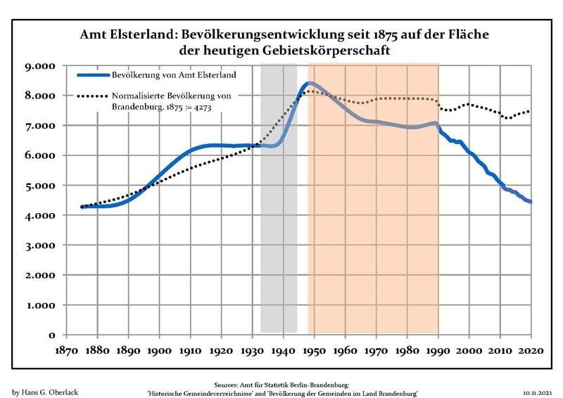
Blaue Linie: Bevölkerung -- Punktierte Linie: Vergleich mit der
Entwicklung Brandenburgs
1189:
352:
100:
371:
I, the copyright holder of this work, hereby publish it under the following license:
266:
Blå linje: Befolkning -- Prickade linjen: Jämförelse med utvecklingen av
Brandenburg
250:
Niebieska linia: Populacja -- Linia przerywana: Porównanie z rozwoju
Brandenburgii
336:
268:
Grå bakgrund: Period av Nazi styre -- Röd bakgrund: Period av kommunistiskt styre
277:
204:
Fond gris: Période du régime nazie -- Fond rouge: Période du régime communiste
172:
Grey background: Time of nazi rule -- Red background: Time of communist rule
156:
Grauer
Hintergrund: Zeit der Nazi-Herrschaft -- Roter Hintergrund: DDR-Zeit
252:
Szare tło: Okres hitlerowców -- Czerwone tło: Okres rządów komunistycznych
216:, circondario di Elbe-Elster, stato federato del Brandeburgo, Germania
188:
Fondo gris: Período del gobierno nazi -- Fondo Rojo: Época communista
164:
Chart of the population development within the current boundaries of
1041:
Click on a date/time to view the file as it appeared at that time.
998:
338:
212:
Sviluppo della popolazione all'interno degli attuali confini di
200:, arrondissement de Elbe-Elster, Land de Brandebourg, Allemagne
148:
Grafik der Bevölkerungsentwicklung in den heutigen Grenzen von
331:
51° 35′ 57.8″ N, 13° 29′ 43.5″ E
321:
88:
228:
Ontwikkeling van de bevolking binnen de huidige grenzen van
232:, landkreis Elbe-Elster, deelstaat Brandenburg, Duitsland
184:, distrito de Elbe-Elster, estado de Brandenburg, Alemania
196:Évolution de la population dans les limites actuelles de
264:, landkreis Elbe-Elster, delstaten Brandenburg, Tyskland
479:
Add a one-line explanation of what this file represents
293:
Population Projection Brandenburg at Wikimedia Commons
180:
Desarrollo de la población en los actuales límites de
152:, Landkreis Elbe-Elster, Land Brandenburg, Deutschland
260:
Befolkningsutvecklingen i de nuvarande gränserna för
78:(1,752 × 1,239 pixels, file size: 123 KB, MIME type:
718:
Creative Commons Attribution-ShareAlike 3.0 Unported
132:
112:
Commons is a freely licensed media file repository.
617:
https://commons.wikimedia.org/user:Hans_G._Oberlack
168:, Elbe-Elster district, Brandenburg state, Germany
248:, powiat Elbe-Elster, kraj Brandenburgia, Niemcy
447:https://creativecommons.org/licenses/by-sa/3.0
280:between 19 September 2012 and 11 November 2021
93:
453:Creative Commons Attribution-Share Alike 3.0
377:
291:Own work based on: Data sources displayed at
8:
413:– to copy, distribute and transmit the work
41:Size of this JPG preview of this PDF file:
1205:
1043:
475:
138:Bevölkerungsentwicklung Amt Elsterland.pdf
244:Rozwój ludności w obecnych granicach dla
821:0589b4ab39325b1006fa537f7dcccad9d4a838cf
1249:
1241:
1233:
1225:
1215:
1207:
1187:
1019:
1003:
985:
969:
948:
932:
911:
895:
874:
858:
819:
803:
785:
769:
751:
735:
715:
699:
679:
663:
596:
580:
560:
543:
526:
509:
493:
490:
471:
464:
324:
345:View this and other nearby images on:
7:
400:Attribution-Share Alike 3.0 Unported
1175:User created page with UploadWizard
1032:
388:
383:
1198:
484:
478:
374:
370:
254:
238:
222:
206:
190:
174:
158:
142:
125:
71:
1091:2017, 2018, 2019, 2020 data added
483:
469:
424:Under the following conditions:
395:This file is licensed under the
387:
382:
376:
351:
337:
92:
21:
466:
255:
207:
175:
159:
14:
1021:51°35'57.800"N, 13°29'43.501"E
465:
239:
191:
143:
26:
1:
1006:coordinates of depicted place
223:
31:
491:Items portrayed in this file
1271:
438:same or compatible license
1033:
16:
1246:841.92 x 595.32 pts (A4)
1155:16:01, 19 September 2012
468:
404:
99:This is a file from the
1174:
1146:
1118:
1090:
1069:23:20, 10 November 2021
298:
287:
276:
273:
135:
103:. Information from its
1230:Microsoft® Excel® 2010
1221:Microsoft® Excel® 2010
1127:12:32, 14 January 2017
1099:08:50, 4 February 2018
357:51.599389; 13.495417
309:Latest population data
106:description page there
1251:Version of PDF format
529:number of individuals
833:determination method
65:1,752 × 1,239 pixels
419:– to adapt the work
47:Other resolutions:
1227:Conversion program
638:Wikimedia username
625:author name string
61:1,280 × 905 pixels
57:1,024 × 724 pixels
1258:
1257:
1178:
753:19 September 2012
702:copyright license
477:
362:
361:
319:
318:
278:19 September 2012
121:
120:
101:Wikimedia Commons
1262:
1206:
1170:Hans G. Oberlack
1165:
1142:Hans G. Oberlack
1137:
1114:Hans G. Oberlack
1109:
1086:Hans G. Oberlack
1081:
953:
916:
879:
842:
837:
666:copyright status
647:
645:Hans G. Oberlack
642:
632:
631:Hans G. Oberlack
629:
619:
614:
460:
457:
454:
451:
448:
440:as the original.
397:Creative Commons
391:
390:
386:
385:
380:
379:
358:
355:
341:
340:
334:
333:
322:
303:Hans G. Oberlack
279:
259:
243:
227:
211:
195:
193:Français :
179:
163:
147:
139:
133:
117:
96:
95:
89:
83:
81:
68:
53:640 × 453 pixels
49:320 × 226 pixels
43:800 × 566 pixels
1270:
1269:
1265:
1264:
1263:
1261:
1260:
1259:
1194:
1186:
1179:
1171:
1163:
1147:2015 data added
1143:
1135:
1119:2016 data added
1115:
1107:
1087:
1079:
1035:
1034:
1031:
1030:
1029:
1028:
1027:
1026:
1025:
1024:
1022:
1012:
1011:
1010:
1008:
997:
996:
995:
994:
993:
992:
991:
990:
988:
978:
977:
976:
974:
972:number of pages
963:
962:
961:
960:
959:
958:
957:
956:
954:
951:
941:
940:
939:
937:
926:
925:
924:
923:
922:
921:
920:
919:
917:
914:
904:
903:
902:
900:
889:
888:
887:
886:
885:
884:
883:
882:
880:
877:
867:
866:
865:
863:
852:
851:
850:
849:
848:
847:
846:
845:
844:
843:
838:
835:
826:
825:
824:
822:
812:
811:
810:
808:
797:
796:
795:
794:
793:
792:
791:
790:
788:
787:application/pdf
778:
777:
776:
774:
763:
762:
761:
760:
759:
758:
757:
756:
754:
744:
743:
742:
740:
729:
728:
727:
726:
725:
724:
723:
722:
720:
708:
707:
706:
704:
693:
692:
691:
690:
689:
688:
687:
686:
684:
672:
671:
670:
668:
657:
656:
655:
654:
653:
652:
651:
650:
649:
648:
643:
640:
634:
633:
630:
627:
621:
620:
615:
612:
603:
602:
601:
599:
589:
588:
587:
585:
574:
573:
572:
571:
570:
569:
568:
567:
565:
554:
553:
552:
551:
550:
548:
537:
536:
535:
534:
533:
531:
520:
519:
518:
517:
516:
514:
502:
501:
500:
498:
482:
481:
480:
463:
462:
461:
458:
455:
452:
449:
446:
445:
403:
392:
373:
372:
367:
356:
329:
328:
325:Object location
320:
312:
283:
269:
253:
237:
221:
214:Amt Elsterland
205:
189:
173:
157:
137:
130:
123:
122:
111:
110:
109:is shown below.
85:
80:application/pdf
79:
77:
70:
69:
46:
12:
11:
5:
1268:
1266:
1256:
1255:
1252:
1248:
1247:
1244:
1240:
1239:
1236:
1232:
1231:
1228:
1224:
1223:
1218:
1214:
1213:
1210:
1197:
1193:
1192:
1190:Amt Elsterland
1184:
1183:
1182:
1177:
1176:
1173:
1169:
1166:
1160:
1157:
1152:
1149:
1148:
1145:
1141:
1138:
1132:
1129:
1124:
1121:
1120:
1117:
1113:
1110:
1104:
1101:
1096:
1093:
1092:
1089:
1085:
1082:
1078:1,752 × 1,239
1076:
1071:
1066:
1062:
1061:
1058:
1055:
1052:
1049:
1046:
1039:
1038:
1023:
1020:
1018:
1017:
1016:
1015:
1014:
1013:
1009:
1004:
1002:
1001:
1000:
999:
989:
986:
984:
983:
982:
981:
980:
979:
975:
970:
968:
967:
966:
965:
964:
955:
949:
947:
946:
945:
944:
943:
942:
938:
933:
931:
930:
929:
928:
927:
918:
912:
910:
909:
908:
907:
906:
905:
901:
896:
894:
893:
892:
891:
890:
881:
875:
873:
872:
871:
870:
869:
868:
864:
859:
857:
856:
855:
854:
853:
831:
830:
829:
828:
827:
823:
820:
818:
817:
816:
815:
814:
813:
809:
804:
802:
801:
800:
799:
798:
789:
786:
784:
783:
782:
781:
780:
779:
775:
770:
768:
767:
766:
765:
764:
755:
752:
750:
749:
748:
747:
746:
745:
741:
736:
734:
733:
732:
731:
730:
721:
716:
714:
713:
712:
711:
710:
709:
705:
700:
698:
697:
696:
695:
694:
685:
680:
678:
677:
676:
675:
674:
673:
669:
664:
662:
661:
660:
659:
658:
636:
635:
623:
622:
608:
607:
606:
605:
604:
600:
597:
595:
594:
593:
592:
591:
590:
586:
581:
579:
578:
577:
576:
575:
566:
563:Amt Elsterland
561:
559:
558:
557:
556:
555:
549:
544:
542:
541:
540:
539:
538:
532:
527:
525:
524:
523:
522:
521:
515:
510:
508:
507:
506:
505:
504:
503:
499:
494:
492:
489:
488:
487:
486:
485:
474:
473:
470:
467:
444:
443:
442:
441:
431:
422:
421:
420:
414:
407:You are free:
394:
393:
375:
369:
368:
366:
363:
360:
359:
349:
343:
326:
317:
316:
313:
310:
306:
305:
300:
296:
295:
289:
285:
284:
281:
275:
271:
270:
262:Amt Elsterland
246:Amt Elsterland
230:Amt Elsterland
198:Amt Elsterland
182:Amt Elsterland
166:Amt Elsterland
150:Amt Elsterland
140:
131:
129:
126:
124:
119:
118:
97:
87:
86:
40:
36:
35:
34:
29:
24:
19:
13:
10:
9:
6:
4:
3:
2:
1267:
1253:
1250:
1245:
1242:
1237:
1234:
1229:
1226:
1222:
1219:
1217:Software used
1216:
1211:
1208:
1204:
1201:
1195:
1191:
1188:
1180:
1172:
1167:
1161:
1158:
1156:
1153:
1151:
1150:
1144:
1139:
1133:
1130:
1128:
1125:
1123:
1122:
1116:
1111:
1105:
1102:
1100:
1097:
1095:
1094:
1088:
1083:
1077:
1075:
1072:
1070:
1067:
1064:
1063:
1059:
1056:
1053:
1050:
1047:
1045:
1044:
1042:
1036:
1007:
973:
936:
899:
862:
841:
834:
807:
773:
739:
719:
703:
683:
667:
646:
639:
626:
618:
611:
584:
564:
547:
530:
513:
497:
450:CC BY-SA 3.0
439:
435:
432:
429:
426:
425:
423:
418:
415:
412:
409:
408:
406:
405:
401:
398:
381:
364:
354:
350:
348:
347:OpenStreetMap
344:
342:
332:
327:
323:
314:
308:
307:
304:
301:
297:
294:
290:
286:
272:
267:
265:
263:
258:
251:
249:
247:
242:
235:
233:
231:
226:
219:
217:
215:
210:
203:
201:
199:
194:
187:
185:
183:
178:
171:
169:
167:
162:
155:
153:
151:
146:
141:
134:
127:
115:
108:
107:
102:
98:
91:
90:
84:
75:
74:Original file
66:
62:
58:
54:
50:
44:
39:
33:
30:
28:
25:
23:
20:
18:
15:
1202:
1199:
1159:No thumbnail
1131:No thumbnail
1103:No thumbnail
1040:
1037:File history
546:demographics
433:
427:
416:
410:
261:
256:
245:
240:
229:
225:Nederlands:
224:
213:
208:
197:
192:
181:
176:
165:
160:
149:
144:
114:You can help
104:
72:
22:File history
682:copyrighted
434:share alike
428:attribution
136:Description
1181:File usage
1054:Dimensions
772:media type
598:some value
209:Italiano:
27:File usage
1243:Page size
1235:Encrypted
1051:Thumbnail
1048:Date/Time
861:data size
738:inception
365:Licensing
311:InfoField
257:Svenska:
177:Español:
161:English:
145:Deutsch:
1196:Metadata
1136:(118 KB)
1108:(120 KB)
1080:(123 KB)
876:125,669
806:checksum
472:Captions
417:to remix
411:to share
402:license.
241:Polski:
32:Metadata
1164:(97 KB)
1065:current
1060:Comment
583:creator
496:depicts
476:English
128:Summary
76:
1209:Author
1162:0 × 0
1134:0 × 0
1106:0 × 0
950:1,752
913:1,239
898:height
335:
299:Author
288:Source
1212:HGO 3
952:pixel
935:width
915:pixel
840:SHA-1
512:chart
1057:User
878:byte
459:true
456:true
315:2020
274:Date
17:File
1254:1.5
610:URL
1238:no
836::
641::
628::
613::
63:|
59:|
55:|
51:|
45:.
987:1
116:.
82:)
67:.
Text is available under the Creative Commons Attribution-ShareAlike License. Additional terms may apply.