43:
380:
341:
355:
386:
391:
99:
1076:
1209:
332:
432:– You must give appropriate credit, provide a link to the license, and indicate if changes were made. You may do so in any reasonable manner, but not in any way that suggests the licensor endorses you or your use.
69:
65:
61:
57:
53:
47:
110:
78:
1156:
1128:
1100:
294:
875:
719:
683:
348:
1075:
1070:
564:
547:
42:
1222:
This file contains additional information, probably added from the digital camera or scanner used to create or digitize it.
530:
646:
439:
513:
1007:
970:
933:
896:
841:
807:
773:
667:
639:
626:
611:
1191:
868:
739:
703:
584:
497:
239:
Blauwe lijn: Bevolking -- Stippellijn: Vergelijking van de ontwikkeling van de bevolking van de deelstaat
Brandenburg
223:
Linea Blu: Popolazione -- Linea puntinata: Confronto dello sviluppo della popolazione dello stato del
Brandenburgo
401:
1242:
1225:
If the file has been modified from its original state, some details may not fully reflect the modified file.
1187:
The following pages on the
English Knowledge (XXG) use this file (pages on other projects are not listed):
1170:
1142:
1114:
1086:
438:– If you remix, transform, or build upon the material, you must distribute your contributions under the
618:
398:
241:
Grijze achtergrond: tijdens de nazi-regering -- Rode achtergrond: tijdens de communistische regering
118:
304:
284:
date QS:P,+2050-00-00T00:00:00Z/7,P1319,+2012-09-27T00:00:00Z/11,P1326,+2021-07-18T00:00:00Z/11
175:
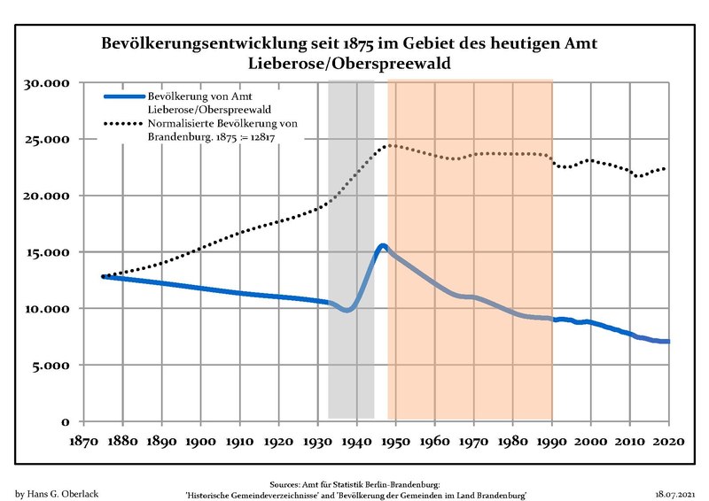
Blue line: Population -- Dotted line: Comparison to population development of
Brandenburg state
207:
Ligne bleue: Population -- Ligne pointillé: Comparaison avec le développement de
Brandebourg
225:
Sfondo grigio: Ai tempi del governo nazista -- Sfondo rosso: Al tempo del governo comunista
191:
Línea azul: Habitantes -- Línea de puntos: Comparación con el desarrollo de
Brandenburgo
159:
Blaue Linie: Bevölkerung -- Punktierte Linie: Vergleich mit der
Entwicklung Brandenburgs
354:
105:
373:
I, the copyright holder of this work, hereby publish it under the following license:
271:
Blå linje: Befolkning -- Prickade linjen: Jämförelse med utvecklingen av
Brandenburg
255:
Niebieska linia: Populacja -- Linia przerywana: Porównanie z rozwoju
Brandenburgii
338:
273:
Grå bakgrund: Period av Nazi styre -- Röd bakgrund: Period av kommunistiskt styre
209:
Fond gris: Période du régime nazie -- Fond rouge: Période du régime communiste
177:
Grey background: Time of nazi rule -- Red background: Time of communist rule
161:
Grauer
Hintergrund: Zeit der Nazi-Herrschaft -- Roter Hintergrund: DDR-Zeit
257:
Szare tło: Okres hitlerowców -- Czerwone tło: Okres rządów komunistycznych
221:, circondario di Dahme-Spreewald, stato federato del Brandeburgo, Germania
193:
Fondo gris: Período del gobierno nazi -- Fondo Rojo: Época communista
205:, arrondissement de Dahme-Spreewald, Land de Brandebourg, Allemagne
1043:
Click on a date/time to view the file as it appeared at that time.
340:
217:
Sviluppo della popolazione all'interno degli attuali confini di
333:
51° 54′ 36.75″ N, 14° 07′ 13.5″ E
323:
237:, landkreis Dahme-Spreewald, deelstaat Brandenburg, Duitsland
189:, distrito de Dahme-Spreewald, estado de Brandenburg, Alemania
93:
766:
269:, landkreis Dahme-Spreewald, delstaten Brandenburg, Tyskland
233:
Ontwikkeling van de bevolking binnen de huidige grenzen van
157:, Landkreis Dahme-Spreewald, Land Brandenburg, Deutschland
201:Évolution de la population dans les limites actuelles de
169:
Population development within the current boundaries of
481:
Add a one-line explanation of what this file represents
143:
Bevölkerungsentwicklung Amt Lieberose-Oberspreewald.pdf
295:
Population Projection Brandenburg at Wikimedia Commons
185:
Desarrollo de la población en los actuales límites de
173:, Dahme-Spreewald district, Brandenburg state, Germany
265:
Befolkningsutvecklingen i de nuvarande gränserna för
253:, powiat Dahme-Spreewald, kraj Brandenburgia, Niemcy
83:(1,752 × 1,239 pixels, file size: 121 KB, MIME type:
720:
Creative Commons Attribution-ShareAlike 3.0 Unported
153:
Bevölkerungsentwicklung in den heutigen Grenzen von
137:
117:
Commons is a freely licensed media file repository.
619:
https://commons.wikimedia.org/user:Hans_G._Oberlack
1210:Ліберозе/Обершпреевальд (об'єднання громад)
449:https://creativecommons.org/licenses/by-sa/3.0
98:
455:Creative Commons Attribution-Share Alike 3.0
379:
293:Own work based on: Data sources displayed at
8:
415:– to copy, distribute and transmit the work
46:Size of this JPG preview of this PDF file:
1227:
1045:
477:
282:between 27 September 2012 and 18 July 2021
1202:The following other wikis use this file:
249:Rozwój ludności w obecnych granicach dla
857:38cbb23bf6eb267d4a1206d9dc9b429d42b72b3f
1271:
1263:
1255:
1247:
1237:
1229:
1189:
1021:
1005:
984:
968:
947:
931:
910:
894:
855:
839:
821:
805:
787:
771:
753:
737:
717:
701:
681:
665:
598:
582:
562:
545:
528:
511:
495:
492:
473:
466:
326:
347:View this and other nearby images on:
7:
402:Attribution-Share Alike 3.0 Unported
1177:User created page with UploadWizard
1034:
390:
385:
1220:
486:
480:
376:
372:
259:
243:
227:
211:
195:
179:
163:
147:
130:
76:
1093:2017, 2018, 2019, 2020 data added
485:
471:
426:Under the following conditions:
397:This file is licensed under the
389:
384:
378:
353:
339:
97:
31:
21:
468:
260:
212:
180:
164:
14:
467:
244:
196:
148:
26:
1:
774:coordinates of depicted place
228:
36:
493:Items portrayed in this file
219:Amt Lieberose/Oberspreewald
1192:Amt Lieberose/Oberspreewald
531:Amt Lieberose/Oberspreewald
267:Amt Lieberose/Oberspreewald
251:Amt Lieberose/Oberspreewald
235:Amt Lieberose/Oberspreewald
203:Amt Lieberose/Oberspreewald
187:Amt Lieberose/Oberspreewald
171:Amt Lieberose/Oberspreewald
155:Amt Lieberose/Oberspreewald
1293:
1206:Usage on uk.wikipedia.org
440:same or compatible license
1035:
789:51°54'36.7"N, 14°7'13.4"E
16:
1268:841.92 x 595.32 pts (A4)
1157:19:39, 27 September 2012
470:
406:
104:This is a file from the
1176:
1148:
1120:
1092:
300:
289:
281:
278:
140:
108:. Information from its
1252:Microsoft® Excel® 2010
1243:Microsoft® Excel® 2010
1101:21:11, 27 January 2018
359:51.910209; 14.120417
311:Latest population data
111:description page there
1273:Version of PDF format
1129:12:11, 7 January 2017
548:number of individuals
869:determination method
70:1,752 × 1,239 pixels
1071:10:46, 18 July 2021
421:– to adapt the work
52:Other resolutions:
1249:Conversion program
640:Wikimedia username
627:author name string
66:1,280 × 905 pixels
62:1,024 × 724 pixels
1280:
1279:
1198:Global file usage
1180:
755:27 September 2012
704:copyright license
479:
364:
363:
321:
320:
126:
125:
106:Wikimedia Commons
32:Global file usage
1284:
1228:
1172:Hans G. Oberlack
1167:
1144:Hans G. Oberlack
1139:
1116:Hans G. Oberlack
1111:
1088:Hans G. Oberlack
1083:
989:
952:
915:
878:
873:
668:copyright status
649:
647:Hans G. Oberlack
644:
634:
633:Hans G. Oberlack
631:
621:
616:
462:
459:
456:
453:
450:
442:as the original.
399:Creative Commons
393:
392:
388:
387:
382:
381:
360:
357:
343:
342:
336:
335:
324:
305:Hans G. Oberlack
264:
248:
232:
216:
200:
198:Français :
184:
168:
152:
144:
138:
122:
101:
100:
94:
88:
86:
73:
58:640 × 453 pixels
54:320 × 226 pixels
48:800 × 566 pixels
1292:
1291:
1287:
1286:
1285:
1283:
1282:
1281:
1216:
1196:
1188:
1181:
1173:
1165:
1149:2015 data added
1145:
1137:
1121:2016 data added
1117:
1109:
1089:
1081:
1037:
1036:
1033:
1032:
1031:
1030:
1029:
1028:
1027:
1026:
1024:
1014:
1013:
1012:
1010:
1008:number of pages
999:
998:
997:
996:
995:
994:
993:
992:
990:
987:
977:
976:
975:
973:
962:
961:
960:
959:
958:
957:
956:
955:
953:
950:
940:
939:
938:
936:
925:
924:
923:
922:
921:
920:
919:
918:
916:
913:
903:
902:
901:
899:
888:
887:
886:
885:
884:
883:
882:
881:
880:
879:
874:
871:
862:
861:
860:
858:
848:
847:
846:
844:
833:
832:
831:
830:
829:
828:
827:
826:
824:
823:application/pdf
814:
813:
812:
810:
799:
798:
797:
796:
795:
794:
793:
792:
790:
780:
779:
778:
776:
765:
764:
763:
762:
761:
760:
759:
758:
756:
746:
745:
744:
742:
731:
730:
729:
728:
727:
726:
725:
724:
722:
710:
709:
708:
706:
695:
694:
693:
692:
691:
690:
689:
688:
686:
674:
673:
672:
670:
659:
658:
657:
656:
655:
654:
653:
652:
651:
650:
645:
642:
636:
635:
632:
629:
623:
622:
617:
614:
605:
604:
603:
601:
591:
590:
589:
587:
576:
575:
574:
573:
572:
571:
570:
569:
567:
556:
555:
554:
553:
552:
550:
539:
538:
537:
536:
535:
533:
522:
521:
520:
519:
518:
516:
504:
503:
502:
500:
484:
483:
482:
465:
464:
463:
460:
457:
454:
451:
448:
447:
405:
394:
375:
374:
369:
358:
331:
330:
327:Object location
322:
314:
285:
274:
258:
242:
226:
210:
194:
178:
162:
142:
135:
128:
127:
116:
115:
114:is shown below.
90:
85:application/pdf
84:
82:
75:
74:
51:
12:
11:
5:
1290:
1288:
1278:
1277:
1274:
1270:
1269:
1266:
1262:
1261:
1258:
1254:
1253:
1250:
1246:
1245:
1240:
1236:
1235:
1232:
1219:
1215:
1214:
1213:
1212:
1200:
1199:
1195:
1194:
1186:
1185:
1184:
1179:
1178:
1175:
1171:
1168:
1162:
1159:
1154:
1151:
1150:
1147:
1143:
1140:
1134:
1131:
1126:
1123:
1122:
1119:
1115:
1112:
1106:
1103:
1098:
1095:
1094:
1091:
1087:
1084:
1080:1,752 × 1,239
1078:
1073:
1068:
1064:
1063:
1060:
1057:
1054:
1051:
1048:
1041:
1040:
1025:
1022:
1020:
1019:
1018:
1017:
1016:
1015:
1011:
1006:
1004:
1003:
1002:
1001:
1000:
991:
985:
983:
982:
981:
980:
979:
978:
974:
969:
967:
966:
965:
964:
963:
954:
948:
946:
945:
944:
943:
942:
941:
937:
932:
930:
929:
928:
927:
926:
917:
911:
909:
908:
907:
906:
905:
904:
900:
895:
893:
892:
891:
890:
889:
867:
866:
865:
864:
863:
859:
856:
854:
853:
852:
851:
850:
849:
845:
840:
838:
837:
836:
835:
834:
825:
822:
820:
819:
818:
817:
816:
815:
811:
806:
804:
803:
802:
801:
800:
791:
788:
786:
785:
784:
783:
782:
781:
777:
772:
770:
769:
768:
767:
757:
754:
752:
751:
750:
749:
748:
747:
743:
738:
736:
735:
734:
733:
732:
723:
718:
716:
715:
714:
713:
712:
711:
707:
702:
700:
699:
698:
697:
696:
687:
682:
680:
679:
678:
677:
676:
675:
671:
666:
664:
663:
662:
661:
660:
638:
637:
625:
624:
610:
609:
608:
607:
606:
602:
599:
597:
596:
595:
594:
593:
592:
588:
583:
581:
580:
579:
578:
577:
568:
563:
561:
560:
559:
558:
557:
551:
546:
544:
543:
542:
541:
540:
534:
529:
527:
526:
525:
524:
523:
517:
512:
510:
509:
508:
507:
506:
505:
501:
496:
494:
491:
490:
489:
488:
487:
476:
475:
472:
469:
446:
445:
444:
443:
433:
424:
423:
422:
416:
409:You are free:
396:
395:
377:
371:
370:
368:
365:
362:
361:
351:
345:
328:
319:
318:
315:
312:
308:
307:
302:
298:
297:
291:
287:
286:
283:
280:
276:
275:
145:
136:
134:
131:
129:
124:
123:
102:
92:
91:
45:
41:
40:
39:
34:
29:
24:
19:
13:
10:
9:
6:
4:
3:
2:
1289:
1275:
1272:
1267:
1264:
1259:
1256:
1251:
1248:
1244:
1241:
1239:Software used
1238:
1233:
1230:
1226:
1223:
1217:
1211:
1208:
1207:
1205:
1204:
1203:
1197:
1193:
1190:
1182:
1174:
1169:
1163:
1160:
1158:
1155:
1153:
1152:
1146:
1141:
1135:
1132:
1130:
1127:
1125:
1124:
1118:
1113:
1107:
1104:
1102:
1099:
1097:
1096:
1090:
1085:
1079:
1077:
1074:
1072:
1069:
1066:
1065:
1061:
1058:
1055:
1052:
1049:
1047:
1046:
1044:
1038:
1009:
972:
935:
898:
877:
870:
843:
809:
775:
741:
721:
705:
685:
669:
648:
641:
628:
620:
613:
586:
566:
549:
532:
515:
499:
452:CC BY-SA 3.0
441:
437:
434:
431:
428:
427:
425:
420:
417:
414:
411:
410:
408:
407:
403:
400:
383:
366:
356:
352:
350:
349:OpenStreetMap
346:
344:
334:
329:
325:
316:
310:
309:
306:
303:
299:
296:
292:
288:
277:
272:
270:
268:
263:
256:
254:
252:
247:
240:
238:
236:
231:
224:
222:
220:
215:
208:
206:
204:
199:
192:
190:
188:
183:
176:
174:
172:
167:
160:
158:
156:
151:
146:
139:
132:
120:
113:
112:
107:
103:
96:
95:
89:
80:
79:Original file
71:
67:
63:
59:
55:
49:
44:
38:
35:
33:
30:
28:
25:
23:
20:
18:
15:
1224:
1221:
1201:
1161:No thumbnail
1133:No thumbnail
1105:No thumbnail
1042:
1039:File history
565:demographics
435:
429:
418:
412:
266:
261:
250:
245:
234:
230:Nederlands:
229:
218:
213:
202:
197:
186:
181:
170:
165:
154:
149:
119:You can help
109:
77:
22:File history
684:copyrighted
436:share alike
430:attribution
141:Description
1183:File usage
1056:Dimensions
808:media type
600:some value
214:Italiano:
27:File usage
1265:Page size
1257:Encrypted
1053:Thumbnail
1050:Date/Time
897:data size
740:inception
367:Licensing
313:InfoField
262:Svenska:
182:Español:
166:English:
150:Deutsch:
1218:Metadata
1138:(119 KB)
1110:(120 KB)
1082:(121 KB)
912:123,473
842:checksum
474:Captions
419:to remix
413:to share
404:license.
246:Polski:
37:Metadata
1166:(97 KB)
1067:current
1062:Comment
585:creator
498:depicts
478:English
133:Summary
81:
1231:Author
1164:0 × 0
1136:0 × 0
1108:0 × 0
986:1,752
949:1,239
934:height
337:
301:Author
290:Source
1234:HGO 3
988:pixel
971:width
951:pixel
876:SHA-1
514:chart
1059:User
914:byte
461:true
458:true
317:2020
279:Date
17:File
1276:1.5
612:URL
1260:no
872::
643::
630::
615::
68:|
64:|
60:|
56:|
50:.
1023:1
121:.
87:)
72:.
Text is available under the Creative Commons Attribution-ShareAlike License. Additional terms may apply.