451:
349:
282:
232:
274:
224:
296:
246:
317:
355:
360:
72:
871:"}},"text\/plain":{"en":{"":"heading"}}},"{\"value\":{\"amount\":\"+270\",\"unit\":\"http:\\\/\\\/www.wikidata.org\\\/entity\\\/Q28390\"},\"type\":\"quantity\"}":{"text\/html":{"en":{"P7787":"270
686:"}},"text\/plain":{"en":{"":"heading"}}},"{\"value\":{\"amount\":\"+270\",\"unit\":\"http:\\\/\\\/www.wikidata.org\\\/entity\\\/Q28390\"},\"type\":\"quantity\"}":{"text\/html":{"en":{"P7787":"270
1173:
867:
215:
1190:== {{int:filedesc}} == {{Information |description={{en|1=Bedwellty Road, Aberbargoed An extremely steep road which leads down to the River Rhymney and then to Bargoed, part of which can be seen on the hill opposite.
Until very recently, this was the only
43:
126:
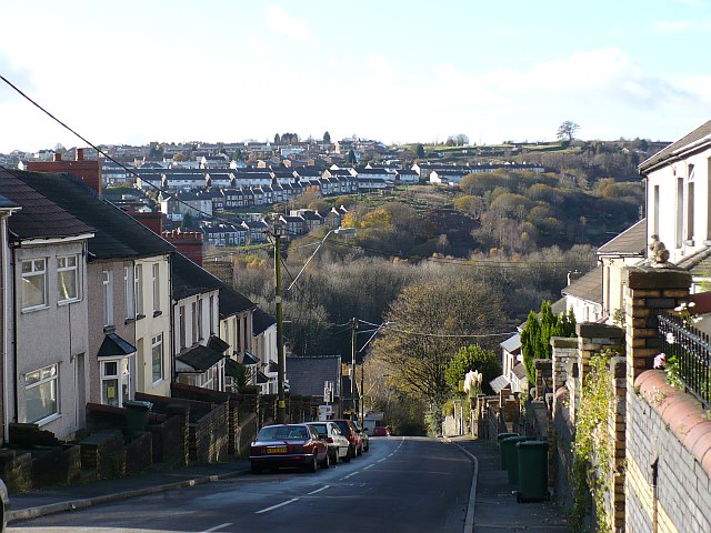
Bedwellty Road, Aberbargoed An extremely steep road which leads down to the River
Rhymney and then to Bargoed, part of which can be seen on the hill opposite. Until very recently, this was the only road connecting Aberbargoed with
407:– You must give appropriate credit, provide a link to the license, and indicate if changes were made. You may do so in any reasonable manner, but not in any way that suggests the licensor endorses you or your use.
83:
51:
471:
460:
868:
683:
1006:
803:
669:
633:
289:
239:
1172:
1167:
42:
838:
1372:
324:
1235:
This file contains additional information, probably added from the digital camera or scanner used to create or digitize it.
414:
581:
1101:
1064:
1027:
972:
938:
909:
882:
816:
787:
724:
697:
617:
589:
574:
561:
999:
846:
831:
753:
653:
534:
517:
311:
370:
1238:
If the file has been modified from its original state, some details may not fully reflect the modified file.
1200:
The following pages on the
English Knowledge (XXG) use this file (pages on other projects are not listed):
1399:
413:– If you remix, transform, or build upon the material, you must distribute your contributions under the
331:
on the
Geograph website for the photographer's contact details. The copyright on this image is owned by
1183:
467:
Please remove redundant categories and try to put this image in the most specific category/categories.
367:
875:"}},"text\/plain":{"en":{"P7787":"270 degree"}}}}": -->
690:"}},"text\/plain":{"en":{"P7787":"270 degree"}}}}": -->
1435:
91:
184:
1516:
1341:
853:
823:
596:
168:
295:
245:
1479:
1417:
1264:
336:
78:
1526:
1489:
1304:
1445:
1204:
136:
1284:
279:
229:
1247:
157:
147:
1536:
1274:
316:
1257:
328:
1140:
Click on a date/time to view the file as it appeared at that time.
281:
231:
256:
206:
66:
116:
Bedwellty Road, Aberbargoed - geograph.org.uk - 1050494.jpg
52:
Bedwellty_Road,_Aberbargoed_-_geograph.org.uk_-_1050494.jpg
457:
The categories of this image need checking. You can do so
266:
51° 41′ 43″ N, 3° 13′ 39″ W
216:
51° 41′ 43″ N, 3° 13′ 35″ W
501:
Add a one-line explanation of what this file represents
1222:
110:
90:
Commons is a freely licensed media file repository.
670:
Creative
Commons Attribution-ShareAlike 2.0 Generic
56:(640 × 480 pixels, file size: 121 KB, MIME type:
1440:Flash did not fire, compulsory flash suppression
424:https://creativecommons.org/licenses/by-sa/2.0
71:
430:Creative Commons Attribution-Share Alike 2.0
348:
8:
872:
687:
390:– to copy, distribute and transmit the work
1240:
1142:
497:
1215:The following other wikis use this file:
854:https://www.geograph.org.uk/photo/1050494
597:https://www.geograph.org.uk/profile/15303
470:You can remove this template by clicking
988:0dc9ad1411680c86fde591cbc34f801a235a5267
1534:
1524:
1514:
1506:
1498:
1487:
1477:
1469:
1461:
1453:
1443:
1433:
1425:
1415:
1407:
1397:
1389:
1381:
1370:
1362:
1354:
1346:
1336:
1328:
1320:
1312:
1301:
1293:
1282:
1272:
1262:
1252:
1202:
1115:
1099:
1078:
1062:
1041:
1025:
986:
970:
952:
936:
896:
880:
801:
785:
767:
751:
711:
695:
667:
651:
631:
615:
548:
532:
515:
512:
493:
486:
259:
209:
288:View this and other nearby images on:
238:View this and other nearby images on:
1242:
7:
335:and is licensed for reuse under the
1131:
371:Attribution-Share Alike 2.0 Generic
359:
354:
339:Attribution-ShareAlike 2.0 license.
1233:
506:
500:
444:
345:
322:
120:
103:
49:
505:
1295:Date and time of data generation
698:coordinates of the point of view
491:
449:
401:Under the following conditions:
366:This file is licensed under the
358:
353:
347:
315:
294:
280:
272:
244:
230:
222:
70:
31:
21:
488:
121:
46:No higher resolution available.
14:
804:file available on the internet
487:
323:This image was taken from the
26:
1:
883:coordinates of depicted place
36:
839:Geograph Britain and Ireland
575:object of statement has role
513:Items portrayed in this file
271:
221:
1383:Date and time of digitizing
898:51°41'42.90"N, 3°13'38.64"W
713:51°41'42.61"N, 3°13'35.04"W
199:Bedwellty Road, Aberbargoed
180:Bedwellty Road, Aberbargoed
1558:
1500:Focal length in 35 mm film
1458:One-chip color area sensor
1219:Usage on www.wikidata.org
448:
415:same or compatible license
197:Robin Drayton /
178:Robin Drayton /
1348:File change date and time
1132:
16:
817:geograph.org.uk image ID
490:
381:
77:This is a file from the
1463:Custom image processing
1386:12:57, 12 November 2008
1351:12:57, 12 November 2008
1298:12:57, 12 November 2008
1189:
1168:00:06, 24 February 2011
474:(or on the first line).
169:required by the license
153:
142:
135:
132:
113:
81:. Information from its
1391:Image compression mode
329:this photograph's page
300:51.695250; -3.227400
250:51.695170; -3.226400
84:description page there
1409:Maximum land aperture
1322:Horizontal resolution
1000:determination method
1356:Y and C positioning
1330:Vertical resolution
1244:Camera manufacturer
396:– to adapt the work
1508:Scene capture type
1484:Auto white balance
562:author name string
1545:
1544:
1269:1/500 sec (0.002)
1211:Global file usage
1193:
874:
689:
654:copyright license
499:
480:
479:
344:
343:
327:collection. See
305:
304:
255:
254:
204:
203:
172:
99:
98:
79:Wikimedia Commons
32:Global file usage
1549:
1364:Exposure Program
1241:
1180:
1120:
1083:
1046:
1009:
1004:
920:
919:
914:
856:
851:
847:described at URL
841:
836:
826:
821:
769:12 November 2008
735:
734:
729:
618:copyright status
599:
594:
584:
579:
569:
566:
453:
452:
446:
445:
437:
434:
431:
428:
425:
417:as the original.
379:
368:Creative Commons
362:
361:
357:
356:
351:
350:
337:Creative Commons
325:Geograph project
319:
312:
301:
298:
284:
283:
277:
276:
275:
269:
268:
257:
251:
248:
234:
233:
227:
226:
225:
219:
218:
207:
166:
138:
137:12 November 2008
125:
117:
111:
95:
74:
73:
67:
61:
59:
1557:
1556:
1552:
1551:
1550:
1548:
1547:
1546:
1412:3 APEX (f/2.83)
1229:
1209:
1201:
1194:
1186:
1178:
1134:
1133:
1130:
1129:
1128:
1127:
1126:
1125:
1124:
1123:
1121:
1118:
1108:
1107:
1106:
1104:
1093:
1092:
1091:
1090:
1089:
1088:
1087:
1086:
1084:
1081:
1071:
1070:
1069:
1067:
1056:
1055:
1054:
1053:
1052:
1051:
1050:
1049:
1047:
1044:
1034:
1033:
1032:
1030:
1019:
1018:
1017:
1016:
1015:
1014:
1013:
1012:
1011:
1010:
1005:
1002:
993:
992:
991:
989:
979:
978:
977:
975:
964:
963:
962:
961:
960:
959:
958:
957:
955:
945:
944:
943:
941:
930:
929:
928:
927:
926:
925:
924:
923:
922:
921:
917:
915:
912:
903:
902:
901:
899:
889:
888:
887:
885:
866:
865:
864:
863:
862:
861:
860:
859:
858:
857:
852:
849:
843:
842:
837:
834:
828:
827:
822:
819:
810:
809:
808:
806:
794:
793:
792:
790:
779:
778:
777:
776:
775:
774:
773:
772:
770:
760:
759:
758:
756:
745:
744:
743:
742:
741:
740:
739:
738:
737:
736:
732:
730:
727:
718:
717:
716:
714:
704:
703:
702:
700:
681:
680:
679:
678:
677:
676:
675:
674:
672:
660:
659:
658:
656:
645:
644:
643:
642:
641:
640:
639:
638:
636:
624:
623:
622:
620:
609:
608:
607:
606:
605:
604:
603:
602:
601:
600:
595:
592:
586:
585:
580:
577:
571:
570:
567:
564:
555:
554:
553:
551:
541:
540:
539:
537:
526:
525:
524:
523:
522:
520:
504:
503:
502:
485:
481:
450:
439:
438:
435:
432:
429:
426:
423:
422:
380:
377:
374:
363:
340:
310:
299:
273:
264:
263:
260:Object location
249:
223:
214:
213:
210:Camera location
205:
194:
187:
175:
148:geograph.org.uk
128:
115:
108:
101:
100:
89:
88:
87:is shown below.
63:
57:
55:
48:
47:
12:
11:
5:
1555:
1553:
1543:
1542:
1539:
1533:
1532:
1529:
1523:
1522:
1519:
1513:
1512:
1509:
1505:
1504:
1501:
1497:
1496:
1493:
1486:
1485:
1482:
1476:
1475:
1472:
1468:
1467:
1466:Normal process
1464:
1460:
1459:
1456:
1455:Sensing method
1452:
1451:
1448:
1442:
1441:
1438:
1432:
1431:
1428:
1424:
1423:
1420:
1414:
1413:
1410:
1406:
1405:
1402:
1396:
1395:
1392:
1388:
1387:
1384:
1380:
1379:
1376:
1369:
1368:
1367:Normal program
1365:
1361:
1360:
1357:
1353:
1352:
1349:
1345:
1344:
1339:
1335:
1334:
1331:
1327:
1326:
1323:
1319:
1318:
1315:
1311:
1310:
1307:
1300:
1299:
1296:
1292:
1291:
1288:
1281:
1280:
1277:
1271:
1270:
1267:
1261:
1260:
1255:
1251:
1250:
1245:
1232:
1228:
1227:
1226:
1225:
1213:
1212:
1208:
1207:
1199:
1198:
1197:
1192:
1191:
1188:
1184:
1181:
1175:
1170:
1165:
1161:
1160:
1157:
1154:
1151:
1148:
1145:
1138:
1137:
1122:
1116:
1114:
1113:
1112:
1111:
1110:
1109:
1105:
1100:
1098:
1097:
1096:
1095:
1094:
1085:
1079:
1077:
1076:
1075:
1074:
1073:
1072:
1068:
1063:
1061:
1060:
1059:
1058:
1057:
1048:
1042:
1040:
1039:
1038:
1037:
1036:
1035:
1031:
1026:
1024:
1023:
1022:
1021:
1020:
998:
997:
996:
995:
994:
990:
987:
985:
984:
983:
982:
981:
980:
976:
971:
969:
968:
967:
966:
965:
956:
953:
951:
950:
949:
948:
947:
946:
942:
937:
935:
934:
933:
932:
931:
908:
907:
906:
905:
904:
900:
897:
895:
894:
893:
892:
891:
890:
886:
881:
879:
878:
877:
876:
870:
845:
844:
830:
829:
815:
814:
813:
812:
811:
807:
802:
800:
799:
798:
797:
796:
795:
791:
788:source of file
786:
784:
783:
782:
781:
780:
771:
768:
766:
765:
764:
763:
762:
761:
757:
752:
750:
749:
748:
747:
746:
723:
722:
721:
720:
719:
715:
712:
710:
709:
708:
707:
706:
705:
701:
696:
694:
693:
692:
691:
685:
673:
668:
666:
665:
664:
663:
662:
661:
657:
652:
650:
649:
648:
647:
646:
637:
632:
630:
629:
628:
627:
626:
625:
621:
616:
614:
613:
612:
611:
610:
588:
587:
573:
572:
560:
559:
558:
557:
556:
552:
549:
547:
546:
545:
544:
543:
542:
538:
533:
531:
530:
529:
528:
527:
521:
516:
514:
511:
510:
509:
508:
507:
496:
495:
492:
489:
478:
477:
476:
475:
468:
454:
443:
421:
420:
419:
418:
408:
399:
398:
397:
391:
384:You are free:
375:
365:
364:
346:
342:
341:
320:
309:
306:
303:
302:
292:
286:
261:
253:
252:
242:
236:
211:
202:
201:
195:
192:
189:
188:
183:
176:
173:
161:
160:
155:
151:
150:
144:
140:
139:
134:
130:
129:
118:
109:
107:
104:
102:
97:
96:
75:
65:
64:
45:
41:
40:
39:
34:
29:
24:
19:
13:
10:
9:
6:
4:
3:
2:
1554:
1540:
1538:
1535:
1530:
1528:
1525:
1520:
1518:
1515:
1510:
1507:
1502:
1499:
1494:
1491:
1488:
1483:
1481:
1480:White balance
1478:
1474:Auto exposure
1473:
1471:Exposure mode
1470:
1465:
1462:
1457:
1454:
1449:
1447:
1444:
1439:
1437:
1434:
1429:
1426:
1421:
1419:
1418:Metering mode
1416:
1411:
1408:
1403:
1401:
1400:Exposure bias
1398:
1393:
1390:
1385:
1382:
1377:
1374:
1371:
1366:
1363:
1358:
1355:
1350:
1347:
1343:
1340:
1338:Software used
1337:
1332:
1329:
1324:
1321:
1316:
1313:
1308:
1306:
1302:
1297:
1294:
1289:
1286:
1283:
1278:
1276:
1273:
1268:
1266:
1265:Exposure time
1263:
1259:
1256:
1253:
1249:
1246:
1243:
1239:
1236:
1230:
1224:
1221:
1220:
1218:
1217:
1216:
1210:
1206:
1203:
1195:
1187:
1182:
1176:
1174:
1171:
1169:
1166:
1163:
1162:
1158:
1155:
1152:
1149:
1146:
1144:
1143:
1141:
1135:
1103:
1066:
1029:
1008:
1001:
974:
940:
911:
884:
855:
848:
840:
833:
825:
818:
805:
789:
755:
726:
699:
671:
655:
635:
619:
598:
591:
583:
576:
568:Robin Drayton
563:
536:
519:
484:
483:
473:
469:
466:
465:
464:
462:
458:
455:
447:
442:
441:
427:CC BY-SA 2.0
416:
412:
409:
406:
403:
402:
400:
395:
392:
389:
386:
385:
383:
382:
378:Robin Drayton
376:Attribution:
372:
369:
352:
338:
334:
333:Robin Drayton
330:
326:
321:
318:
314:
313:
307:
297:
293:
291:
290:OpenStreetMap
287:
285:
267:
262:
258:
247:
243:
241:
240:OpenStreetMap
237:
235:
217:
212:
208:
200:
196:
191:
190:
186:
182: /
181:
177:
170:
165:
163:
162:
159:
158:Robin Drayton
156:
152:
149:
145:
141:
131:
124:
119:
112:
105:
93:
86:
85:
80:
76:
69:
68:
62:
53:
44:
38:
35:
33:
30:
28:
25:
23:
20:
18:
15:
1490:Digital zoom
1427:Light source
1305:focal length
1254:Camera model
1237:
1234:
1214:
1139:
1136:File history
582:photographer
482:
459:
456:
440:
410:
404:
393:
387:
332:
270:
220:
198:
185:CC BY-SA 2.0
179:
122:
92:You can help
82:
50:
22:File history
1446:Color space
1314:Orientation
1205:Aberbargoed
1185:GeographBot
634:copyrighted
411:share alike
405:attribution
164:Attribution
114:Description
1527:Saturation
1196:File usage
1177:640 × 480
1153:Dimensions
954:image/jpeg
939:media type
550:some value
58:image/jpeg
27:File usage
1537:Sharpness
1342:Ver.1.0
1285:ISO speed
1248:Panasonic
1150:Thumbnail
1147:Date/Time
1028:data size
754:inception
308:Licensing
193:InfoField
174:InfoField
123:English:
1517:Contrast
1511:Standard
1359:Co-sited
1275:F-number
1231:Metadata
1223:Q2564732
1179:(121 KB)
1043:123,696
973:checksum
832:operator
494:Captions
394:to remix
388:to share
373:license.
127:Bargoed.
37:Metadata
1430:Unknown
1422:Pattern
1375:version
1258:DMC-LZ7
1164:current
1159:Comment
910:heading
869:heading
824:1050494
725:heading
684:heading
535:creator
518:depicts
498:English
106:Summary
54:
1541:Normal
1531:Normal
1521:Normal
1333:72 dpi
1325:72 dpi
1317:Normal
1309:8.9 mm
1287:rating
1065:height
918:degree
873:degree
733:degree
688:degree
278:
228:
154:Author
143:Source
1503:54 mm
1492:ratio
1436:Flash
1303:Lens
1279:f/3.1
1119:pixel
1102:width
1082:pixel
1007:SHA-1
146:From
1450:sRGB
1378:2.21
1373:Exif
1156:User
1117:640
1080:480
1045:byte
916:270
731:270
472:here
461:here
436:true
433:true
133:Date
17:File
1290:100
590:URL
1003::
913::
850::
835::
820::
728::
593::
578::
565::
1495:0
1404:0
1394:4
463:.
171:)
167:(
94:.
60:)
Text is available under the Creative Commons Attribution-ShareAlike License. Additional terms may apply.
_heading:270.00&language=en)
_heading:270.00&language=en)
