212:
43:
218:
223:
91:
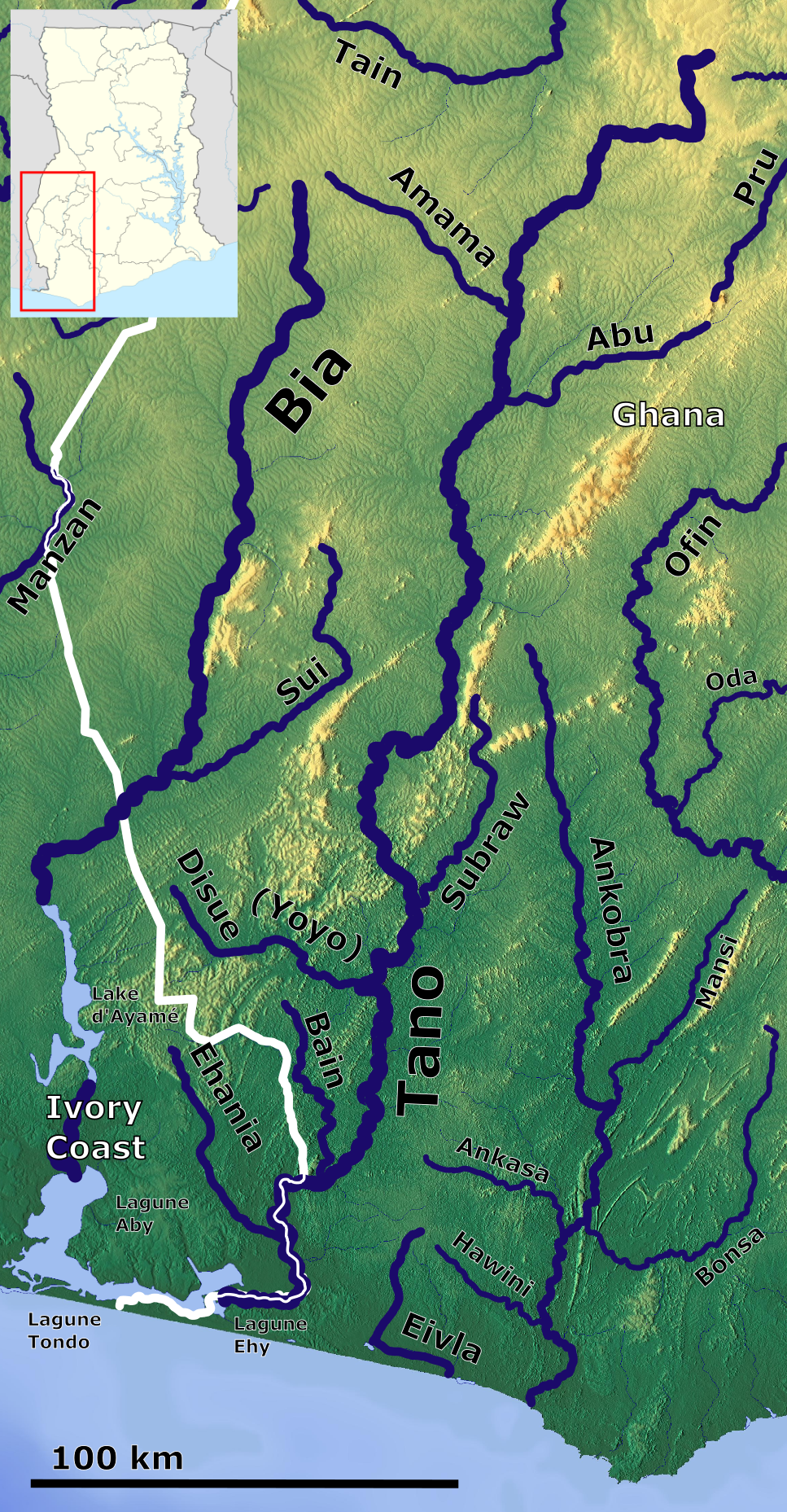
720:== {{int:filedesc}} == {{Information |description ={{en|1=Bia - Tano - Ankobra River_OSM. Based up on US Army map NB30}} |date =2022-06-05 |source =https://maps-for-free.com/, https://maps.lib.utexas.edu/maps/imw/ |author =Hans Braxmeier &
703:
264:– You must give appropriate credit, provide a link to the license, and indicate if changes were made. You may do so in any reasonable manner, but not in any way that suggests the licensor endorses you or your use.
57:
53:
47:
102:
70:
536:
414:
397:
361:
847:
This file contains additional information, probably added from the digital camera or scanner used to create or digitize it.
271:
631:
594:
557:
502:
468:
345:
725:
529:
434:
381:
328:
200:
233:
850:
If the file has been modified from its original state, some details may not fully reflect the modified file.
737:
The following pages on the
English Knowledge (XXG) use this file (pages on other projects are not listed):
270:– If you remix, transform, or build upon the material, you must distribute your contributions under the
230:
110:
702:
697:
61:
42:
878:
182:
721:
713:
190:
97:
186:
172:
154:
746:
741:
168:
670:
Click on a date/time to view the file as it appeared at that time.
784:
85:
173:
https://commons.wikimedia.org/File:Ghana_adm_location_map.svg
164:
145:
Bia - Tano - Ankobra River_OSM. Based up on US Army map NB30
789:
809:
769:
774:
799:
312:
Add a one-line explanation of what this file represents
834:
829:
764:
415:
Creative
Commons Attribution-ShareAlike 3.0 Unported
129:
109:
Commons is a freely licensed media file repository.
75:(967 × 1,857 pixels, file size: 3.43 MB, MIME type:
398:
Creative
Commons Attribution-ShareAlike 2.0 Generic
819:
281:https://creativecommons.org/licenses/by-sa/3.0
90:
287:Creative Commons Attribution-Share Alike 3.0
211:
8:
247:– to copy, distribute and transmit the work
852:
672:
308:
757:The following other wikis use this file:
518:c77c58a559098c1e1dee20911beff1c484679bc3
875:
870:
862:
854:
739:
645:
629:
608:
592:
571:
555:
516:
500:
482:
466:
448:
432:
412:
395:
379:
359:
343:
326:
323:
304:
297:
724:|other_versions= }} {{cc-by-sa-2.0}}
169:https://maps.lib.utexas.edu/maps/imw/
7:
234:Attribution-Share Alike 3.0 Unported
661:
222:
217:
845:
317:
311:
208:
139:
122:
68:
316:
726:Category:Maps of rivers of Ghana
302:
258:Under the following conditions:
229:This file is licensed under the
221:
216:
210:
89:
31:
21:
299:
140:
14:
298:
26:
1:
201:File:Bia Tano Ankobra OSM.jpg
36:
324:Items portrayed in this file
135:Bia - Tano - Ankobra OSM.png
900:
826:Usage on pt.wikipedia.org
816:Usage on pl.wikipedia.org
806:Usage on it.wikipedia.org
796:Usage on id.wikipedia.org
781:Usage on fr.wikipedia.org
761:Usage on de.wikipedia.org
272:same or compatible license
165:https://maps-for-free.com/
662:
16:
301:
238:
96:This is a file from the
719:
196:
178:
160:
153:
150:
132:
100:. Information from its
103:description page there
46:Size of this preview:
856:Horizontal resolution
530:determination method
864:Vertical resolution
253:– to adapt the work
52:Other resolutions:
698:05:36, 5 June 2022
62:967 × 1,857 pixels
887:
886:
753:Global file usage
730:
382:copyright license
310:
206:
205:
118:
117:
98:Wikimedia Commons
32:Global file usage
891:
881:
879:www.inkscape.org
853:
710:
650:
613:
576:
539:
534:
346:copyright status
294:
291:
288:
285:
282:
274:as the original.
231:Creative Commons
225:
224:
220:
219:
214:
213:
156:
144:
136:
130:
114:
93:
92:
86:
80:
78:
65:
58:250 × 480 pixels
54:125 × 240 pixels
48:312 × 599 pixels
899:
898:
894:
893:
892:
890:
889:
888:
877:
841:
751:
738:
731:
716:
708:
664:
663:
660:
659:
658:
657:
656:
655:
654:
653:
651:
648:
638:
637:
636:
634:
623:
622:
621:
620:
619:
618:
617:
616:
614:
611:
601:
600:
599:
597:
586:
585:
584:
583:
582:
581:
580:
579:
577:
574:
564:
563:
562:
560:
549:
548:
547:
546:
545:
544:
543:
542:
541:
540:
535:
532:
523:
522:
521:
519:
509:
508:
507:
505:
494:
493:
492:
491:
490:
489:
488:
487:
485:
475:
474:
473:
471:
460:
459:
458:
457:
456:
455:
454:
453:
451:
441:
440:
439:
437:
426:
425:
424:
423:
422:
421:
420:
419:
417:
406:
405:
404:
403:
402:
400:
388:
387:
386:
384:
373:
372:
371:
370:
369:
368:
367:
366:
364:
352:
351:
350:
348:
337:
336:
335:
334:
333:
331:
315:
314:
313:
296:
295:
292:
289:
286:
283:
280:
279:
237:
226:
207:
189:, Location map:
171:, Location map:
146:
134:
127:
120:
119:
108:
107:
106:is shown below.
82:
76:
74:
67:
66:
51:
12:
11:
5:
897:
895:
885:
884:
883:
882:
873:
869:
868:
865:
861:
860:
857:
844:
840:
839:
838:
837:
832:
824:
823:
822:
814:
813:
812:
804:
803:
802:
794:
793:
792:
787:
779:
778:
777:
772:
767:
755:
754:
750:
749:
744:
736:
735:
734:
729:
728:
718:
714:
711:
705:
700:
695:
691:
690:
687:
684:
681:
678:
675:
668:
667:
652:
646:
644:
643:
642:
641:
640:
639:
635:
630:
628:
627:
626:
625:
624:
615:
609:
607:
606:
605:
604:
603:
602:
598:
593:
591:
590:
589:
588:
587:
578:
572:
570:
569:
568:
567:
566:
565:
561:
556:
554:
553:
552:
551:
550:
528:
527:
526:
525:
524:
520:
517:
515:
514:
513:
512:
511:
510:
506:
501:
499:
498:
497:
496:
495:
486:
483:
481:
480:
479:
478:
477:
476:
472:
467:
465:
464:
463:
462:
461:
452:
449:
447:
446:
445:
444:
443:
442:
438:
433:
431:
430:
429:
428:
427:
418:
413:
411:
410:
409:
408:
407:
401:
396:
394:
393:
392:
391:
390:
389:
385:
380:
378:
377:
376:
375:
374:
365:
360:
358:
357:
356:
355:
354:
353:
349:
344:
342:
341:
340:
339:
338:
332:
327:
325:
322:
321:
320:
319:
318:
307:
306:
303:
300:
278:
277:
276:
275:
265:
256:
255:
254:
248:
241:You are free:
228:
227:
209:
204:
203:
198:
197:Other versions
194:
193:
183:Hans Braxmeier
180:
176:
175:
162:
158:
157:
152:
148:
147:
137:
128:
126:
123:
121:
116:
115:
94:
84:
83:
45:
41:
40:
39:
34:
29:
24:
19:
13:
10:
9:
6:
4:
3:
2:
896:
880:
876:
874:
872:Software used
871:
866:
863:
858:
855:
851:
848:
842:
836:
833:
831:
828:
827:
825:
821:
818:
817:
815:
811:
808:
807:
805:
801:
798:
797:
795:
791:
790:Tano (fleuve)
788:
786:
785:Bia (rivière)
783:
782:
780:
776:
773:
771:
768:
766:
763:
762:
760:
759:
758:
752:
748:
745:
743:
740:
732:
727:
723:
717:
712:
706:
704:
701:
699:
696:
693:
692:
688:
685:
682:
679:
676:
674:
673:
671:
665:
633:
596:
559:
538:
531:
504:
470:
436:
416:
399:
383:
363:
347:
330:
284:CC BY-SA 3.0
273:
269:
266:
263:
260:
259:
257:
252:
249:
246:
243:
242:
240:
239:
235:
232:
215:
202:
199:
195:
192:
188:
184:
181:
177:
174:
170:
166:
163:
159:
149:
143:
138:
131:
124:
112:
105:
104:
99:
95:
88:
87:
81:
72:
71:Original file
63:
59:
55:
49:
44:
38:
35:
33:
30:
28:
25:
23:
20:
18:
15:
849:
846:
810:Tano (fiume)
770:Tano (Fluss)
756:
707:967 × 1,857
669:
666:File history
267:
261:
250:
244:
191:NordNordWest
141:
111:You can help
101:
69:
22:File history
775:Bia (Fluss)
450:5 June 2022
362:copyrighted
268:share alike
262:attribution
155:5 June 2022
133:Description
800:Sungai Bia
747:Tano River
733:File usage
722:Peter in s
715:Peter in s
683:Dimensions
573:3,599,099
469:media type
187:Peter in s
27:File usage
867:35.03 dpc
859:35.03 dpc
742:Bia River
709:(3.43 MB)
680:Thumbnail
677:Date/Time
558:data size
484:image/png
435:inception
142:English:
77:image/png
843:Metadata
835:Rio Tano
503:checksum
305:Captions
251:to remix
245:to share
236:license.
37:Metadata
830:Rio Bia
765:Ankobra
694:current
689:Comment
329:depicts
309:English
125:Summary
73:
610:1,857
595:height
185:&
179:Author
161:Source
649:pixel
632:width
612:pixel
537:SHA-1
820:Tano
686:User
647:967
575:byte
293:true
290:true
151:Date
17:File
533::
167:,
60:|
56:|
50:.
113:.
79:)
64:.
Text is available under the Creative Commons Attribution-ShareAlike License. Additional terms may apply.