278:
211:
203:
225:
246:
284:
289:
72:
603:"}},"text\/plain":{"en":{"":"heading"}}},"{\"value\":{\"amount\":\"+90\",\"unit\":\"http:\\\/\\\/www.wikidata.org\\\/entity\\\/Q28390\"},\"type\":\"quantity\"}":{"text\/html":{"en":{"P7787":"90
599:
130:
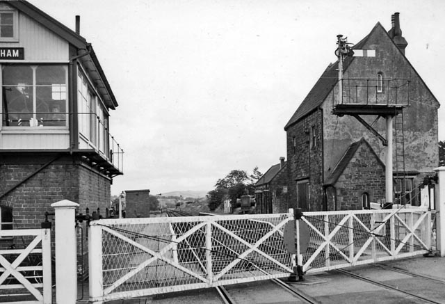
View eastward, towards
Cockermouth (and Bullgill); London & NOrth Western Penrith - Keswick - Cockermouth - Workington line, former junction of Maryport & Carlisle branch from Bullgill. The station was closed, together with the line from Keswick on 18/4/66 - and is now the A66 road; the line
1009:== {{int:filedesc}} == {{Information |Description={{en|1=Brigham (Cumberland) Station View eastward, towards Cockermouth (and Bullgill); London & NOrth Western Penrith - Keswick - Cockermouth - Workington line, former junction of Maryport & Carlisle branc
43:
194:
336:– You must give appropriate credit, provide a link to the license, and indicate if changes were made. You may do so in any reasonable manner, but not in any way that suggests the licensor endorses you or your use.
51:
83:
600:
1108:
172:
825:
686:
552:
516:
218:
706:
253:
1064:
This file contains additional information, probably added from the digital camera or scanner used to create or digitize it.
343:
479:
920:
883:
846:
791:
757:
714:
670:
641:
614:
500:
472:
457:
444:
991:
986:
42:
818:
729:
699:
572:
536:
417:
400:
240:
299:
1067:
If the file has been modified from its original state, some details may not fully reflect the modified file.
1023:
342:– If you remix, transform, or build upon the material, you must distribute your contributions under the
260:
on the
Geograph website for the photographer's contact details. The copyright on this image is owned by
296:
607:"}},"text\/plain":{"en":{"P7787":"90 degree"}}}}": -->
91:
736:
721:
464:
224:
265:
78:
208:
1123:
1002:
1041:
140:
161:
151:
245:
257:
959:
Click on a date/time to view the file as it appeared at that time.
210:
195:
54° 39′ 57.31″ N, 3° 25′ 13.11″ W
185:
66:
384:
Add a one-line explanation of what this file represents
1051:
179:
Creative
Commons Attribution Share-alike license 2.0
110:
90:
Commons is a freely licensed media file repository.
553:
Creative
Commons Attribution-ShareAlike 2.0 Generic
116:Brigham (Cumberland) Station 1906983 1c110717.jpg
52:Brigham_(Cumberland)_Station_1906983_1c110717.jpg
56:(640 × 437 pixels, file size: 81 KB, MIME type:
353:https://creativecommons.org/licenses/by-sa/2.0
71:
359:Creative Commons Attribution-Share Alike 2.0
277:
8:
604:
319:– to copy, distribute and transmit the work
1069:
961:
380:
1034:The following other wikis use this file:
737:https://www.geograph.org.uk/photo/1906983
465:https://www.geograph.org.uk/profile/44502
807:ace96006a8052708f49fdc7e1d0938d8c9faff0d
1121:
1113:
1103:
1095:
1087:
1079:
1071:
1021:
934:
918:
897:
881:
860:
844:
805:
789:
771:
755:
684:
668:
628:
612:
586:
570:
550:
534:
514:
498:
431:
415:
398:
395:
376:
369:
188:
217:View this and other nearby images on:
7:
1109:Adobe Photoshop Elements 3.0 Windows
264:and is licensed for reuse under the
1019:The following page uses this file:
950:
300:Attribution-Share Alike 2.0 Generic
288:
283:
268:Attribution-ShareAlike 2.0 license.
1062:
1042:Cockermouth and Workington Railway
389:
383:
274:
251:
120:
103:
49:
388:
131:from Bullgill had closed in 4/35.
615:coordinates of the point of view
374:
330:Under the following conditions:
295:This file is licensed under the
287:
282:
276:
244:
223:
209:
201:
70:
31:
21:
371:
121:
46:No higher resolution available.
14:
687:file available on the internet
370:
252:This image was taken from the
26:
1:
630:54°39'57.308"N, 3°25'13.105"W
127:Brigham (Cumberland) Station.
36:
707:Geograph Britain and Ireland
473:object of statement has role
396:Items portrayed in this file
200:
1145:
1048:Usage on www.wikidata.org
1038:Usage on de.wikipedia.org
344:same or compatible license
1115:File change date and time
951:
16:
715:geograph.org.uk image ID
373:
310:
77:This is a file from the
1024:Brigham railway station
1008:
987:11:09, 20 December 2010
167:
157:
146:
139:
136:
113:
81:. Information from its
258:this photograph's page
229:54.665919; -3.420307
84:description page there
1089:Horizontal resolution
819:determination method
1097:Vertical resolution
1076:EPSON scanner image
325:– to adapt the work
1118:22:23, 9 June 2010
445:author name string
1132:
1131:
1030:Global file usage
1012:
606:
588:25 September 1961
537:copyright license
382:
273:
272:
256:collection. See
234:
233:
183:
182:
176:
173:Reusing this file
141:25 September 1961
99:
98:
79:Wikimedia Commons
32:Global file usage
1136:
1070:
999:
939:
902:
865:
828:
823:
739:
734:
730:described at URL
724:
719:
709:
704:
652:
651:
646:
501:copyright status
482:
477:
467:
462:
452:
449:
366:
363:
360:
357:
354:
346:as the original.
308:
297:Creative Commons
291:
290:
286:
285:
280:
279:
266:Creative Commons
254:Geograph project
248:
241:
230:
227:
213:
212:
206:
205:
204:
198:
197:
186:
170:
142:
125:
117:
111:
95:
74:
73:
67:
61:
59:
1144:
1143:
1139:
1138:
1137:
1135:
1134:
1133:
1058:
1028:
1013:
1005:
997:
953:
952:
949:
948:
947:
946:
945:
944:
943:
942:
940:
937:
927:
926:
925:
923:
912:
911:
910:
909:
908:
907:
906:
905:
903:
900:
890:
889:
888:
886:
875:
874:
873:
872:
871:
870:
869:
868:
866:
863:
853:
852:
851:
849:
838:
837:
836:
835:
834:
833:
832:
831:
830:
829:
824:
821:
812:
811:
810:
808:
798:
797:
796:
794:
783:
782:
781:
780:
779:
778:
777:
776:
774:
764:
763:
762:
760:
749:
748:
747:
746:
745:
744:
743:
742:
741:
740:
735:
732:
726:
725:
720:
717:
711:
710:
705:
702:
693:
692:
691:
689:
677:
676:
675:
673:
662:
661:
660:
659:
658:
657:
656:
655:
654:
653:
649:
647:
644:
635:
634:
633:
631:
621:
620:
619:
617:
598:
597:
596:
595:
594:
593:
592:
591:
589:
579:
578:
577:
575:
564:
563:
562:
561:
560:
559:
558:
557:
555:
543:
542:
541:
539:
528:
527:
526:
525:
524:
523:
522:
521:
519:
507:
506:
505:
503:
492:
491:
490:
489:
488:
487:
486:
485:
484:
483:
478:
475:
469:
468:
463:
460:
454:
453:
450:
447:
438:
437:
436:
434:
424:
423:
422:
420:
409:
408:
407:
406:
405:
403:
387:
386:
385:
368:
367:
364:
361:
358:
355:
352:
351:
309:
306:
303:
292:
269:
239:
228:
202:
193:
192:
189:Camera location
184:
152:geograph.org.uk
132:
115:
108:
101:
100:
89:
88:
87:is shown below.
63:
57:
55:
48:
47:
12:
11:
5:
1142:
1140:
1130:
1129:
1126:
1120:
1119:
1116:
1112:
1111:
1106:
1102:
1101:
1098:
1094:
1093:
1090:
1086:
1085:
1082:
1078:
1077:
1074:
1061:
1057:
1056:
1055:
1054:
1046:
1045:
1044:
1032:
1031:
1027:
1026:
1017:
1016:
1011:
1010:
1007:
1003:
1000:
994:
989:
984:
980:
979:
976:
973:
970:
967:
964:
957:
956:
941:
935:
933:
932:
931:
930:
929:
928:
924:
919:
917:
916:
915:
914:
913:
904:
898:
896:
895:
894:
893:
892:
891:
887:
882:
880:
879:
878:
877:
876:
867:
861:
859:
858:
857:
856:
855:
854:
850:
845:
843:
842:
841:
840:
839:
817:
816:
815:
814:
813:
809:
806:
804:
803:
802:
801:
800:
799:
795:
790:
788:
787:
786:
785:
784:
775:
772:
770:
769:
768:
767:
766:
765:
761:
756:
754:
753:
752:
751:
750:
728:
727:
713:
712:
698:
697:
696:
695:
694:
690:
685:
683:
682:
681:
680:
679:
678:
674:
671:source of file
669:
667:
666:
665:
664:
663:
640:
639:
638:
637:
636:
632:
629:
627:
626:
625:
624:
623:
622:
618:
613:
611:
610:
609:
608:
602:
590:
587:
585:
584:
583:
582:
581:
580:
576:
571:
569:
568:
567:
566:
565:
556:
551:
549:
548:
547:
546:
545:
544:
540:
535:
533:
532:
531:
530:
529:
520:
515:
513:
512:
511:
510:
509:
508:
504:
499:
497:
496:
495:
494:
493:
471:
470:
456:
455:
451:Ben Brooksbank
443:
442:
441:
440:
439:
435:
432:
430:
429:
428:
427:
426:
425:
421:
416:
414:
413:
412:
411:
410:
404:
399:
397:
394:
393:
392:
391:
390:
379:
378:
375:
372:
350:
349:
348:
347:
337:
328:
327:
326:
320:
313:You are free:
307:Ben Brooksbank
304:
294:
293:
275:
271:
270:
262:Ben Brooksbank
249:
238:
235:
232:
231:
221:
215:
190:
181:
180:
177:
165:
164:
162:Ben Brooksbank
159:
155:
154:
148:
144:
143:
138:
134:
133:
118:
109:
107:
104:
102:
97:
96:
75:
65:
64:
45:
41:
40:
39:
34:
29:
24:
19:
13:
10:
9:
6:
4:
3:
2:
1141:
1127:
1125:
1122:
1117:
1114:
1110:
1107:
1105:Software used
1104:
1099:
1096:
1091:
1088:
1083:
1080:
1075:
1072:
1068:
1065:
1059:
1053:
1050:
1049:
1047:
1043:
1040:
1039:
1037:
1036:
1035:
1029:
1025:
1022:
1020:
1014:
1006:
1001:
995:
993:
990:
988:
985:
982:
981:
977:
974:
971:
968:
965:
963:
962:
960:
954:
922:
885:
848:
827:
820:
793:
759:
738:
731:
723:
716:
708:
701:
688:
672:
643:
616:
574:
554:
538:
518:
502:
481:
474:
466:
459:
446:
419:
402:
356:CC BY-SA 2.0
345:
341:
338:
335:
332:
331:
329:
324:
321:
318:
315:
314:
312:
311:
305:Attribution:
301:
298:
281:
267:
263:
259:
255:
250:
247:
243:
242:
236:
226:
222:
220:
219:OpenStreetMap
216:
214:
196:
191:
187:
178:
174:
169:
166:
163:
160:
156:
153:
149:
145:
135:
129:
128:
124:
119:
112:
105:
93:
86:
85:
80:
76:
69:
68:
62:
53:
44:
38:
35:
33:
30:
28:
25:
23:
20:
18:
15:
1128:Uncalibrated
1066:
1063:
1033:
1018:
958:
955:File history
480:photographer
339:
333:
322:
316:
261:
199:
126:
122:
92:You can help
82:
50:
22:File history
1124:Color space
1081:Orientation
1073:Image title
517:copyrighted
340:share alike
334:attribution
114:Description
1015:File usage
996:640 × 437
972:Dimensions
773:image/jpeg
758:media type
433:some value
168:Permission
58:image/jpeg
27:File usage
969:Thumbnail
966:Date/Time
847:data size
573:inception
237:Licensing
123:English:
1060:Metadata
1052:Q4967329
792:checksum
700:operator
377:Captions
323:to remix
317:to share
302:license.
37:Metadata
998:(81 KB)
983:current
978:Comment
862:83,262
722:1906983
642:heading
601:heading
418:creator
401:depicts
381:English
106:Summary
54:
1100:78 dpc
1092:78 dpc
1084:Normal
1004:Chevin
884:height
650:degree
605:degree
207:
158:Author
147:Source
938:pixel
921:width
901:pixel
826:SHA-1
150:From
975:User
936:640
899:437
864:byte
365:true
362:true
137:Date
17:File
648:90
458:URL
822::
733::
718::
703::
645::
476::
461::
448::
175:)
171:(
94:.
60:)
Text is available under the Creative Commons Attribution-ShareAlike License. Additional terms may apply.
_Station_1906983_1c110717.jpg)
_Station_1906983_1c110717.jpg¶ms=054.665919_N_-003.420307_E_globe:Earth_type:camera_heading:90.00&language=en)
