362:
297:
247:
289:
239:
311:
261:
330:
368:
373:
72:
859:"}},"text\/plain":{"en":{"":"heading"}}},"{\"value\":{\"amount\":\"+0\",\"unit\":\"http:\\\/\\\/www.wikidata.org\\\/entity\\\/Q28390\"},\"type\":\"quantity\"}":{"text\/html":{"en":{"P7787":"0
795:"}},"text\/plain":{"en":{"":"heading"}}},"{\"value\":{\"amount\":\"+0\",\"unit\":\"http:\\\/\\\/www.wikidata.org\\\/entity\\\/Q28390\"},\"type\":\"quantity\"}":{"text\/html":{"en":{"P7787":"0
855:
280:
230:
420:– You must give appropriate credit, provide a link to the license, and indicate if changes were made. You may do so in any reasonable manner, but not in any way that suggests the licensor endorses you or your use.
43:
856:
792:
1228:
1214:{{Information |Description={{en|1=Moyses Hall in Bury St Edmunds, Suffolk, England. A Grade I listed medieval building.}} |Source= |Author= |Date
83:
1238:
51:
1030:
693:
657:
621:
502:
304:
254:
728:
337:
1299:
This file contains additional information, probably added from the digital camera or scanner used to create or digitize it.
942:
427:
584:
1125:
1088:
1051:
996:
962:
926:
897:
870:
833:
806:
706:
677:
605:
577:
562:
549:
1023:
764:
736:
721:
641:
522:
486:
1233:
324:
383:
1302:
If the file has been modified from its original state, some details may not fully reflect the modified file.
1224:
The following pages on the
English Knowledge (XXG) use this file (pages on other projects are not listed):
426:– If you remix, transform, or build upon the material, you must distribute your contributions under the
344:
on the
Geograph website for the photographer's contact details. The copyright on this image is owned by
476:"}},"text\/plain":{"en":{"P180":"Moyse's Hall"}}}}": -->
380:
115:
1196:
1191:
42:
863:"}},"text\/plain":{"en":{"P7787":"0 degree"}}}}": -->
799:"}},"text\/plain":{"en":{"P7787":"0 degree"}}}}": -->
91:
199:
110:
743:
713:
569:
183:
310:
260:
349:
143:
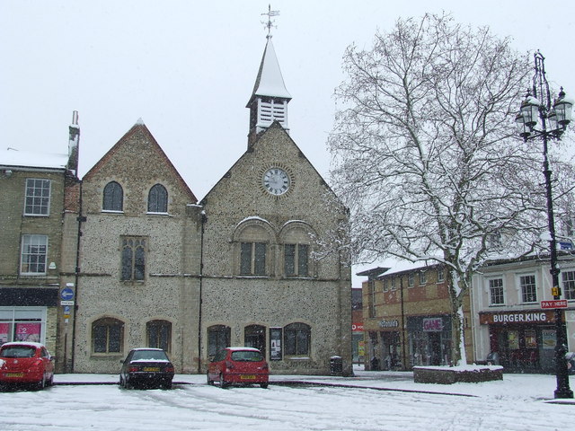
Moyses Hall in Bury St
Edmunds, Suffolk, England. A Grade I listed medieval building.
78:
152:
1207:
1266:
294:
244:
172:
162:
329:
341:
1164:
Click on a date/time to view the file as it appeared at that time.
296:
246:
271:
221:
66:
1256:
1276:
281:
52° 14′ 47″ N, 0° 42′ 46″ E
231:
52° 14′ 45″ N, 0° 42′ 46″ E
468:
Add a one-line explanation of what this file represents
1286:
127:
104:
90:
Commons is a freely licensed media file repository.
658:
Creative
Commons Attribution-ShareAlike 2.0 Generic
56:(640 × 480 pixels, file size: 104 KB, MIME type:
437:https://creativecommons.org/licenses/by-sa/2.0
71:
443:Creative Commons Attribution-Share Alike 2.0
361:
322:Commons Attribution Share-alike license 2.0
8:
860:
796:
403:– to copy, distribute and transmit the work
1304:
1229:Grade I listed buildings in St Edmundsbury
1166:
464:
1249:The following other wikis use this file:
1012:f3bc0af862d8977a266a237ac641eb6b66ca7c21
744:https://www.geograph.org.uk/photo/734859
570:https://www.geograph.org.uk/profile/6337
1306:
1226:
1139:
1123:
1102:
1086:
1065:
1049:
1010:
994:
976:
960:
940:
924:
884:
868:
820:
804:
778:
762:
691:
675:
655:
639:
619:
603:
536:
520:
500:
484:
481:
460:
453:
274:
224:
303:View this and other nearby images on:
253:View this and other nearby images on:
1239:List of places of interest in Suffolk
7:
348:and is licensed for reuse under the
1155:
384:Attribution-Share Alike 2.0 Generic
372:
367:
352:Attribution-ShareAlike 2.0 license.
1297:
473:
467:
358:
335:
137:
108:
103:
49:
472:
133:Bury St Edmunds - Moyses Hall.jpg
52:Bury_St_Edmunds_-_Moyses_Hall.jpg
807:coordinates of the point of view
458:
414:Under the following conditions:
379:This file is licensed under the
371:
366:
360:
328:
309:
295:
287:
259:
245:
237:
70:
31:
21:
455:
138:
46:No higher resolution available.
14:
694:file available on the internet
454:
336:This image was taken from the
26:
1:
871:coordinates of depicted place
36:
729:Geograph Britain and Ireland
578:object of statement has role
482:Items portrayed in this file
1267:Liste des musées du Suffolk
1253:Usage on en.wikivoyage.org
886:52°14'46.54"N, 0°42'46.08"E
822:52°14'45.28"N, 0°42'46.08"E
1328:
1283:Usage on www.wikidata.org
1273:Usage on pl.wikipedia.org
1263:Usage on fr.wikipedia.org
1234:List of museums in Suffolk
428:same or compatible license
286:
236:
1156:
16:
707:geograph.org.uk image ID
457:
394:
212:Keith Evans /
193:Keith Evans /
77:This is a file from the
1213:
214:Moyses Hall in the snow
195:Moyses Hall in the snow
184:required by the license
168:
158:
151:
148:
130:
81:. Information from its
342:this photograph's page
315:52.246260; 0.712800
265:52.245910; 0.712800
84:description page there
1024:determination method
927:location of creation
1192:23:18, 23 July 2009
409:– to adapt the work
109:This is a photo of
550:author name string
1315:
1314:
1245:Global file usage
1217:
862:
798:
642:copyright license
466:
357:
356:
340:collection. See
320:
319:
270:
269:
219:
218:
187:
125:
124:
99:
98:
79:Wikimedia Commons
32:Global file usage
1319:
1305:
1204:
1144:
1107:
1070:
1033:
1028:
908:
907:
902:
844:
843:
838:
746:
741:
737:described at URL
731:
726:
716:
711:
606:copyright status
587:
582:
572:
567:
557:
554:
450:
447:
444:
441:
438:
430:as the original.
392:
381:Creative Commons
375:
374:
370:
369:
364:
363:
350:Creative Commons
338:Geograph project
332:
325:
316:
313:
299:
298:
292:
291:
290:
284:
283:
272:
266:
263:
249:
248:
242:
241:
240:
234:
233:
222:
181:
154:
142:
134:
128:
118:
105:
95:
74:
73:
67:
61:
59:
1327:
1326:
1322:
1321:
1320:
1318:
1317:
1316:
1293:
1257:Bury St Edmunds
1243:
1225:
1218:
1210:
1202:
1158:
1157:
1154:
1153:
1152:
1151:
1150:
1149:
1148:
1147:
1145:
1142:
1132:
1131:
1130:
1128:
1117:
1116:
1115:
1114:
1113:
1112:
1111:
1110:
1108:
1105:
1095:
1094:
1093:
1091:
1080:
1079:
1078:
1077:
1076:
1075:
1074:
1073:
1071:
1068:
1058:
1057:
1056:
1054:
1043:
1042:
1041:
1040:
1039:
1038:
1037:
1036:
1035:
1034:
1029:
1026:
1017:
1016:
1015:
1013:
1003:
1002:
1001:
999:
988:
987:
986:
985:
984:
983:
982:
981:
979:
969:
968:
967:
965:
954:
953:
952:
951:
950:
949:
948:
947:
945:
943:Bury St Edmunds
933:
932:
931:
929:
918:
917:
916:
915:
914:
913:
912:
911:
910:
909:
905:
903:
900:
891:
890:
889:
887:
877:
876:
875:
873:
854:
853:
852:
851:
850:
849:
848:
847:
846:
845:
841:
839:
836:
827:
826:
825:
823:
813:
812:
811:
809:
790:
789:
788:
787:
786:
785:
784:
783:
781:
771:
770:
769:
767:
756:
755:
754:
753:
752:
751:
750:
749:
748:
747:
742:
739:
733:
732:
727:
724:
718:
717:
712:
709:
700:
699:
698:
696:
684:
683:
682:
680:
669:
668:
667:
666:
665:
664:
663:
662:
660:
648:
647:
646:
644:
633:
632:
631:
630:
629:
628:
627:
626:
624:
612:
611:
610:
608:
597:
596:
595:
594:
593:
592:
591:
590:
589:
588:
583:
580:
574:
573:
568:
565:
559:
558:
555:
552:
543:
542:
541:
539:
529:
528:
527:
525:
514:
513:
512:
511:
510:
509:
508:
507:
505:
493:
492:
491:
489:
474:
470:
469:
452:
451:
448:
445:
442:
439:
436:
435:
393:
390:
387:
376:
353:
314:
288:
279:
278:
275:Object location
264:
238:
229:
228:
225:Camera location
220:
209:
202:
190:
163:geograph.org.uk
144:
132:
120:
114:
111:listed building
101:
100:
89:
88:
87:is shown below.
63:
57:
55:
48:
47:
12:
11:
5:
1325:
1323:
1313:
1312:
1309:
1296:
1292:
1291:
1290:
1289:
1281:
1280:
1279:
1277:St Edmundsbury
1271:
1270:
1269:
1261:
1260:
1259:
1247:
1246:
1242:
1241:
1236:
1231:
1223:
1222:
1221:
1216:
1215:
1212:
1208:
1205:
1199:
1194:
1189:
1185:
1184:
1181:
1178:
1175:
1172:
1169:
1162:
1161:
1146:
1140:
1138:
1137:
1136:
1135:
1134:
1133:
1129:
1124:
1122:
1121:
1120:
1119:
1118:
1109:
1103:
1101:
1100:
1099:
1098:
1097:
1096:
1092:
1087:
1085:
1084:
1083:
1082:
1081:
1072:
1066:
1064:
1063:
1062:
1061:
1060:
1059:
1055:
1050:
1048:
1047:
1046:
1045:
1044:
1022:
1021:
1020:
1019:
1018:
1014:
1011:
1009:
1008:
1007:
1006:
1005:
1004:
1000:
995:
993:
992:
991:
990:
989:
980:
977:
975:
974:
973:
972:
971:
970:
966:
961:
959:
958:
957:
956:
955:
946:
941:
939:
938:
937:
936:
935:
934:
930:
925:
923:
922:
921:
920:
919:
896:
895:
894:
893:
892:
888:
885:
883:
882:
881:
880:
879:
878:
874:
869:
867:
866:
865:
864:
858:
832:
831:
830:
829:
828:
824:
821:
819:
818:
817:
816:
815:
814:
810:
805:
803:
802:
801:
800:
794:
782:
779:
777:
776:
775:
774:
773:
772:
768:
763:
761:
760:
759:
758:
757:
735:
734:
720:
719:
705:
704:
703:
702:
701:
697:
692:
690:
689:
688:
687:
686:
685:
681:
678:source of file
676:
674:
673:
672:
671:
670:
661:
656:
654:
653:
652:
651:
650:
649:
645:
640:
638:
637:
636:
635:
634:
625:
620:
618:
617:
616:
615:
614:
613:
609:
604:
602:
601:
600:
599:
598:
576:
575:
561:
560:
548:
547:
546:
545:
544:
540:
537:
535:
534:
533:
532:
531:
530:
526:
521:
519:
518:
517:
516:
515:
506:
501:
499:
498:
497:
496:
495:
494:
490:
485:
483:
480:
479:
478:
477:
475:
463:
462:
459:
456:
434:
433:
432:
431:
421:
412:
411:
410:
404:
397:You are free:
388:
378:
377:
359:
355:
354:
333:
318:
317:
307:
301:
276:
268:
267:
257:
251:
226:
217:
216:
210:
207:
204:
203:
198:
191:
188:
176:
175:
170:
166:
165:
160:
156:
155:
150:
146:
145:
135:
126:
123:
122:
102:
97:
96:
75:
65:
64:
45:
41:
40:
39:
34:
29:
24:
19:
13:
10:
9:
6:
4:
3:
2:
1324:
1310:
1307:
1303:
1300:
1294:
1288:
1285:
1284:
1282:
1278:
1275:
1274:
1272:
1268:
1265:
1264:
1262:
1258:
1255:
1254:
1252:
1251:
1250:
1244:
1240:
1237:
1235:
1232:
1230:
1227:
1219:
1211:
1206:
1200:
1198:
1195:
1193:
1190:
1187:
1186:
1182:
1179:
1176:
1173:
1170:
1168:
1167:
1165:
1159:
1127:
1090:
1053:
1032:
1025:
998:
964:
944:
928:
899:
872:
835:
808:
780:23 March 2008
766:
745:
738:
730:
723:
715:
708:
695:
679:
659:
643:
623:
607:
586:
579:
571:
564:
551:
524:
504:
488:
440:CC BY-SA 2.0
429:
425:
422:
419:
416:
415:
413:
408:
405:
402:
399:
398:
396:
395:
389:Attribution:
385:
382:
365:
351:
347:
343:
339:
334:
331:
327:
326:
323:
312:
308:
306:
305:OpenStreetMap
302:
300:
282:
277:
273:
262:
258:
256:
255:OpenStreetMap
252:
250:
232:
227:
223:
215:
211:
206:
205:
201:
197: /
196:
192:
185:
180:
178:
177:
174:
171:
167:
164:
161:
157:
153:23 March 2008
147:
141:
136:
129:
121:
117:
112:
107:
106:
93:
86:
85:
80:
76:
69:
68:
62:
53:
44:
38:
35:
33:
30:
28:
25:
23:
20:
18:
15:
1301:
1298:
1248:
1163:
1160:File history
585:photographer
503:Moyse's Hall
423:
417:
406:
400:
345:
321:
285:
235:
213:
200:CC BY-SA 2.0
194:
139:
92:You can help
82:
50:
22:File history
622:copyrighted
556:Keith Evans
424:share alike
418:attribution
391:Keith Evans
346:Keith Evans
179:Attribution
173:Keith Evans
131:Description
1308:_error
1220:File usage
1201:640 × 480
1177:Dimensions
978:image/jpeg
963:media type
538:some value
58:image/jpeg
27:File usage
1287:Q17526591
1174:Thumbnail
1171:Date/Time
1052:data size
765:inception
208:InfoField
189:InfoField
140:English:
1295:Metadata
1203:(104 KB)
1067:106,628
997:checksum
722:operator
461:Captions
407:to remix
401:to share
386:license.
37:Metadata
1188:current
1183:Comment
898:heading
857:heading
834:heading
793:heading
523:creator
487:depicts
465:English
116:1076931
113:number
54:
1089:height
906:degree
861:degree
842:degree
797:degree
714:734859
293:
243:
169:Author
159:Source
1209:Aldux
1143:pixel
1126:width
1106:pixel
1031:SHA-1
1180:User
1141:640
1104:480
1069:byte
449:true
446:true
149:Date
17:File
563:URL
1027::
904:0
901::
840:0
837::
740::
725::
710::
581::
566::
553::
1311:0
186:)
182:(
119:.
94:.
60:)
Text is available under the Creative Commons Attribution-ShareAlike License. Additional terms may apply.
_heading:0.00&language=en)
_heading:0.00&language=en)
