290:
182:
132:
174:
196:
146:
258:
296:
301:
82:
566:"}},"text\/plain":{"en":{"":"heading"}}},"{\"value\":{\"amount\":\"+315\",\"unit\":\"http:\\\/\\\/www.wikidata.org\\\/entity\\\/Q28390\"},\"type\":\"quantity\"}":{"text\/html":{"en":{"P7787":"315
562:
685:{{Information |Description=Beach between the Shiants. The two main islands of the Shiants (Garbh Eilean and Eilean nan Tigh) are joined by a beach which is sometimes inundated. The gap between the two steep islands is a motorway for auks. The Shiants are
165:
668:
348:– You must give appropriate credit, provide a link to the license, and indicate if changes were made. You may do so in any reasonable manner, but not in any way that suggests the licensor endorses you or your use.
123:
563:
481:
445:
189:
139:
265:
355:
704:
604:
577:
535:
429:
501:
465:
412:
252:
48:
42:
93:
311:
61:
354:– If you remix, transform, or build upon the material, you must distribute your contributions under the
272:
on the
Geograph website for the photographer's contact details. The copyright on this image is owned by
308:
570:"}},"text\/plain":{"en":{"P7787":"315 degree"}}}}": -->
101:
699:
195:
145:
277:
88:
678:
667:
662:
52:
37:
226:
129:
179:
257:
236:
269:
635:
Click on a date/time to view the file as it appeared at that time.
181:
131:
528:
124:
57° 53′ 34.55″ N, 6° 21′ 24.77″ W
156:
114:
76:
732:
737:
722:
166:
57° 53′ 42″ N, 6° 21′ 36″ W
396:
Add a one-line explanation of what this file represents
207:
100:
Commons is a freely licensed media file repository.
482:
Creative
Commons Attribution-ShareAlike 2.0 Generic
66:(412 × 640 pixels, file size: 61 KB, MIME type:
365:https://creativecommons.org/licenses/by-sa/2.0
81:
371:Creative Commons Attribution-Share Alike 2.0
289:
8:
567:
331:– to copy, distribute and transmit the work
637:
392:
715:The following other wikis use this file:
697:
591:
575:
549:
533:
515:
499:
479:
463:
443:
427:
410:
407:
388:
381:
159:
117:
188:View this and other nearby images on:
138:View this and other nearby images on:
695:The following 2 pages use this file:
7:
276:and is licensed for reuse under the
626:
312:Attribution-Share Alike 2.0 Generic
300:
295:
280:Attribution-ShareAlike 2.0 license.
401:
395:
286:
263:
113:
59:
400:
536:coordinates of the point of view
386:
342:Under the following conditions:
307:This file is licensed under the
299:
294:
288:
256:
194:
180:
172:
144:
130:
80:
31:
21:
383:
14:
382:
264:This image was taken from the
218:looking north to Garbh Eilean.
26:
1:
578:coordinates of depicted place
705:Garbh Eilean, Shiant Islands
408:Items portrayed in this file
171:
551:57°53'34.55"N, 6°21'24.77"W
756:
729:Usage on nn.wikipedia.org
719:Usage on ga.wikipedia.org
356:same or compatible license
627:
593:57°53'42.4"N, 6°21'36.0"W
16:
385:
322:
87:This is a file from the
684:
242:
232:
225:
222:
210:
91:. Information from its
270:this photograph's page
200:57.895100; -6.360000
150:57.892930; -6.356880
94:description page there
41:Size of this preview:
663:13:04, 21 July 2007
337:– to adapt the work
47:Other resolutions:
711:Global file usage
688:
569:
466:copyright license
394:
285:
284:
268:collection. See
250:
249:
213:Garbh Eilean2.jpg
205:
204:
155:
154:
109:
108:
89:Wikimedia Commons
32:Global file usage
747:
733:Eilean an Taighe
700:Eilean an Taighe
675:
615:
614:
609:
430:copyright status
378:
375:
372:
369:
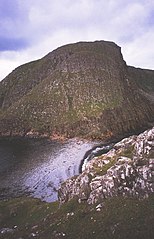
366:
358:as the original.
320:
309:Creative Commons
303:
302:
298:
297:
292:
291:
278:Creative Commons
266:Geograph project
260:
253:
228:
214:
208:
201:
198:
184:
183:
177:
176:
175:
169:
168:
157:
151:
148:
134:
133:
127:
126:
115:
105:
84:
83:
77:
71:
69:
56:
53:412 × 640 pixels
49:154 × 240 pixels
43:386 × 600 pixels
755:
754:
750:
749:
748:
746:
745:
744:
709:
689:
681:
673:
629:
628:
625:
624:
623:
622:
621:
620:
619:
618:
617:
616:
612:
610:
607:
598:
597:
596:
594:
584:
583:
582:
580:
561:
560:
559:
558:
557:
556:
555:
554:
552:
542:
541:
540:
538:
527:
526:
525:
524:
523:
522:
521:
520:
518:
508:
507:
506:
504:
493:
492:
491:
490:
489:
488:
487:
486:
484:
472:
471:
470:
468:
457:
456:
455:
454:
453:
452:
451:
450:
448:
436:
435:
434:
432:
421:
420:
419:
418:
417:
415:
399:
398:
397:
380:
379:
376:
373:
370:
367:
364:
363:
321:
318:
315:
304:
281:
251:
212:
199:
173:
164:
163:
160:Object location
149:
122:
121:
118:Camera location
111:
110:
99:
98:
97:is shown below.
73:
67:
65:
58:
57:
46:
12:
11:
5:
753:
751:
743:
742:
741:
740:
735:
727:
726:
725:
713:
712:
708:
707:
702:
693:
692:
687:
686:
683:
679:
676:
670:
665:
660:
656:
655:
652:
649:
646:
643:
640:
633:
632:
603:
602:
601:
600:
599:
595:
592:
590:
589:
588:
587:
586:
585:
581:
576:
574:
573:
572:
571:
565:
553:
550:
548:
547:
546:
545:
544:
543:
539:
534:
532:
531:
530:
529:
519:
516:
514:
513:
512:
511:
510:
509:
505:
500:
498:
497:
496:
495:
494:
485:
480:
478:
477:
476:
475:
474:
473:
469:
464:
462:
461:
460:
459:
458:
449:
444:
442:
441:
440:
439:
438:
437:
433:
428:
426:
425:
424:
423:
422:
416:
411:
409:
406:
405:
404:
403:
402:
391:
390:
387:
384:
362:
361:
360:
359:
349:
340:
339:
338:
332:
325:You are free:
316:
306:
305:
287:
283:
282:
261:
248:
247:
244:
240:
239:
234:
230:
229:
224:
220:
219:
215:
206:
203:
202:
192:
186:
161:
153:
152:
142:
136:
119:
112:
107:
106:
85:
75:
74:
40:
36:
35:
34:
29:
24:
19:
13:
10:
9:
6:
4:
3:
2:
752:
739:
736:
734:
731:
730:
728:
724:
721:
720:
718:
717:
716:
710:
706:
703:
701:
698:
696:
690:
682:
677:
671:
669:
666:
664:
661:
658:
657:
653:
650:
647:
644:
641:
639:
638:
636:
630:
606:
579:
537:
503:
483:
467:
447:
431:
414:
368:CC BY-SA 2.0
357:
353:
350:
347:
344:
343:
341:
336:
333:
330:
327:
326:
324:
323:
317:Attribution:
313:
310:
293:
279:
275:
271:
267:
262:
259:
255:
254:
245:
241:
238:
235:
231:
221:
216:
209:
197:
193:
191:
190:OpenStreetMap
187:
185:
167:
162:
158:
147:
143:
141:
140:OpenStreetMap
137:
135:
125:
120:
116:
103:
96:
95:
90:
86:
79:
78:
72:
63:
62:Original file
54:
50:
44:
39:
33:
30:
28:
25:
23:
20:
18:
15:
738:Garbh Eilean
723:Garbh Eilean
714:
694:
634:
631:File history
351:
345:
334:
328:
319:Richard Webb
274:Richard Webb
273:
246:Richard Webb
170:
102:You can help
92:
60:
22:File history
517:3 July 2002
446:copyrighted
352:share alike
346:attribution
227:3 July 2002
211:Description
691:File usage
672:412 × 640
648:Dimensions
68:image/jpeg
27:File usage
645:Thumbnail
642:Date/Time
502:inception
389:Captions
335:to remix
329:to share
314:license.
237:Geograph
680:Finavon
674:(61 KB)
659:current
654:Comment
605:heading
564:heading
413:depicts
393:English
64:
613:degree
568:degree
243:Author
233:Source
178:
128:
651:User
611:315
377:true
374:true
223:Date
17:File
608::
51:|
45:.
104:.
70:)
55:.
Text is available under the Creative Commons Attribution-ShareAlike License. Additional terms may apply.

_region:GB-SCT_heading:315.00&language=en)
