358:
43:
159:
364:
369:
140:
99:
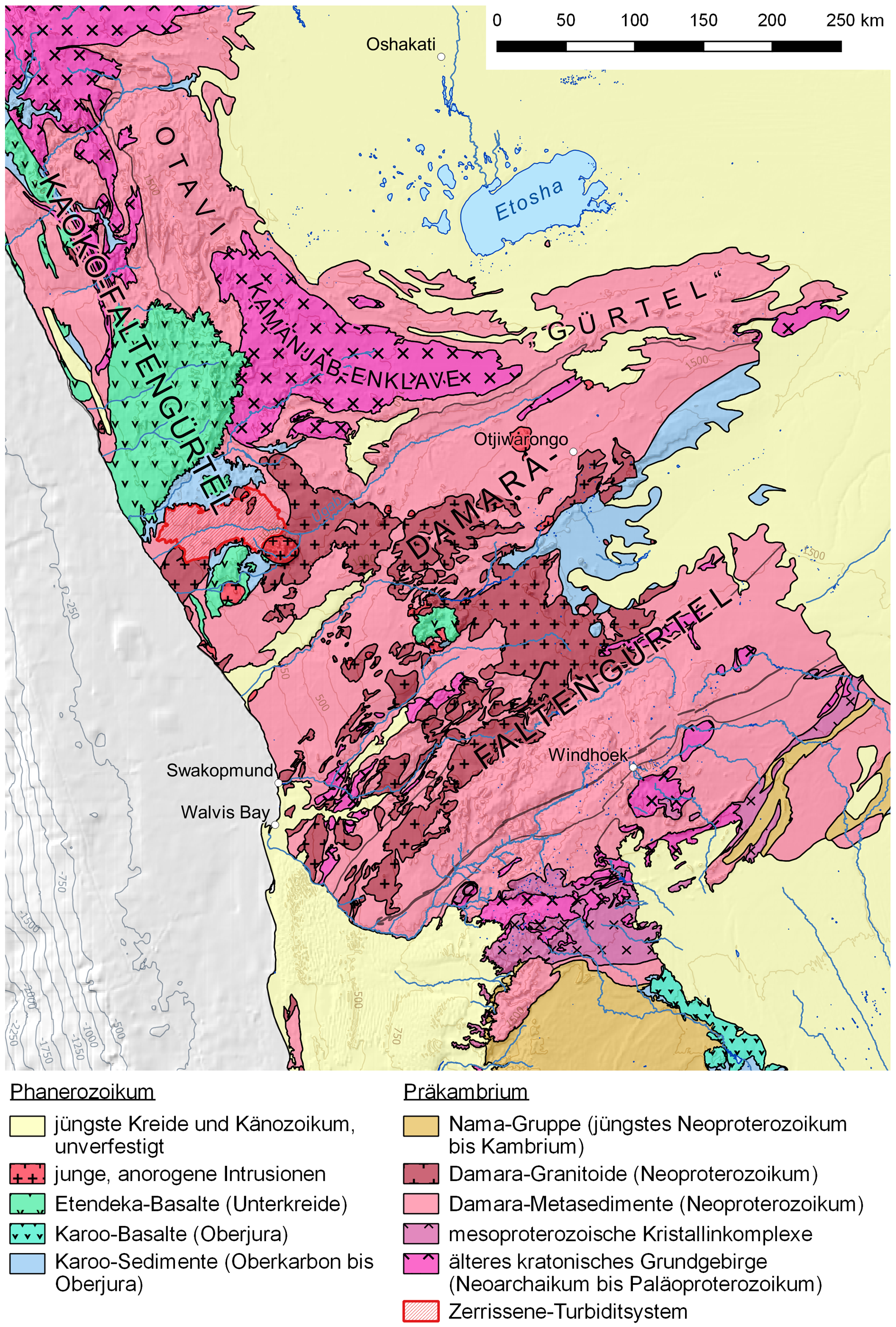
769:{{Information |Description ={{de|1=Karte der Oberflächengeologie des zentralen Teils Namibias mit Kennzeichnung der Lage des Zerrissene Turbidite Systems}} {{en|1=Map of the surficial geology of the central part of Namibia with the position of the...
752:
410:– You must give appropriate credit, provide a link to the license, and indicate if changes were made. You may do so in any reasonable manner, but not in any way that suggests the licensor endorses you or your use.
816:
225:
261:
Shape of outcrop of the
Zerrissene Turbidite System digitized from Landsat 7 images (false color, band combination 7-5-4), downloaded at
245:
Digital
Elevation Model for creating the hillshade background layer and contour lines: SRTM 30 arc second tile GeoTIFFs, downloaded at
65:
61:
57:
53:
47:
663:
627:
591:
110:
251:
Rivers, lakes, places and borders: Open Street Map data (created by Open Street Map contributors, 2017, distributed under the
78:
829:
This file contains additional information, probably added from the digital camera or scanner used to create or digitize it.
195:
Map of the surficial geology of the central part of
Namibia with the position of the Zerrissene Turbidite System highlighted
417:
647:
575:
547:
532:
519:
683:
611:
492:
475:
187:
Karte der Oberflächengeologie des zentralen Teils
Namibias mit Kennzeichnung der Lage des Zerrissene Turbidite Systems
539:
379:
832:
If the file has been modified from its original state, some details may not fully reflect the modified file.
230:
Atlas of
Namibia Project (2002), Directorate of Environmental Affairs, Ministry of Environment and Tourism
321:
416:– If you remix, transform, or build upon the material, you must distribute your contributions under the
298:
D. R. Gray, D. A. Foster, J. G. Meert, B. D. Goscombe, R. Armstrong, R. A. J. Trouw, C. W. Passchier:
376:
286:
779:
The following pages on the
English Knowledge use this file (pages on other projects are not listed):
788:
316:
Malcolm W. Wallace, Ashleigh v.S. Hood, Estee M.S. Woon, Karl-Heinz
Hoffmann, Christopher P. Reed:
783:
118:
554:
146:
268:
Labels are according to
Passchier et al. (2002), Gray et al. (2008), and Wallace et al. (2014)
165:
751:
746:
69:
42:
762:
318:
Enigmatic chambered structures in
Cryogenian reefs: The oldest sponge-grade organisms?
252:
105:
351:
I, the copyright holder of this work, hereby publish it under the following license:
335:
256:
240:
246:
204:
158:
303:
233:
806:
221:
Mainly created with QGIS, finalized with Adobe
Illustrator and Photoshop
281:
C. W. Passchier, R. A. J. Trouw, A. Ribeiro, F. V. P. Paciullo (2002):
300:
A Damara orogen perspective on the assembly of southwestern Gondwana.
719:
Click on a date/time to view the file as it appeared at that time.
262:
150:
139:
302:
Geological Society, London, Special Publications 294:257–278,
93:
628:
Creative Commons Attribution-ShareAlike 4.0 International
459:
Add a one-line explanation of what this file represents
283:
Tectonic evolution of the southern Kaoko belt, Namibia.
277:
275:
83:(1,890 × 2,799 pixels, file size: 3.41 MB, MIME type:
247:
NOAA’s National Centers for Environmental Information
171:
117:
Commons is a freely licensed media file repository.
285:Journal of African Earth Sciences 35(1):61–75,
427:https://creativecommons.org/licenses/by-sa/4.0
224:Geological spatial data (shape file) are from
98:
555:https://commons.wikimedia.org/user:Gretarsson
433:Creative Commons Attribution-Share Alike 4.0
357:
8:
393:– to copy, distribute and transmit the work
834:
721:
455:
265:, and according to Passchier et al. (2002)
799:The following other wikis use this file:
380:Attribution-Share Alike 4.0 International
844:
836:
781:
697:
681:
661:
645:
625:
609:
589:
573:
506:
490:
473:
470:
451:
444:
271:
253:Open Data Commons Open Database License
234:http://209.88.21.36/Atlas/Atlas_web.htm
320:Precambrian Research 255(1):109–123,
7:
710:
368:
363:
322:doi:10.1016/j.precamres.2014.09.020
827:
464:
458:
354:
350:
189:
181:
163:
144:
130:
76:
463:
287:doi:10.1016/S0899-5362(02)00030-1
226:Digital Atlas of Namibia: Geology
449:
404:Under the following conditions:
375:This file is licensed under the
367:
362:
356:
157:
138:
97:
31:
21:
446:
311:
293:
255:), downloaded as shapefiles at
190:
14:
445:
182:
26:
1:
664:original creation by uploader
164:This image was created with
36:
471:Items portrayed in this file
807:Zerrissene Turbidite System
866:
813:Usage on uk.wikipedia.org
803:Usage on de.wikipedia.org
418:same or compatible license
711:
215:
177:Geomap Zentralnamibia.png
16:
448:
384:
228:which, in turn, credits
104:This is a file from the
768:
331:
239:colours and symbols by
210:
203:
200:
174:
108:. Information from its
111:description page there
46:Size of this preview:
838:Horizontal resolution
304:doi:10.1144/SP294.14
70:1,890 × 2,799 pixels
846:Vertical resolution
789:Omingonde Formation
747:17:35, 22 June 2017
399:– to adapt the work
263:USGS Earth Explorer
52:Other resolutions:
784:Geology of Namibia
533:Wikimedia username
520:author name string
66:691 × 1,024 pixels
853:
852:
817:Географія Намібії
795:Global file usage
772:
612:copyright license
457:
341:
340:
149:was created with
126:
125:
106:Wikimedia Commons
32:Global file usage
857:
835:
759:
576:copyright status
557:
552:
542:
537:
527:
524:
440:
437:
434:
431:
428:
420:as the original.
377:Creative Commons
371:
370:
366:
365:
360:
359:
325:
314:
307:
296:
289:
279:
217:
206:
194:
186:
178:
172:
161:
142:
122:
101:
100:
94:
88:
86:
73:
62:518 × 768 pixels
58:324 × 480 pixels
54:162 × 240 pixels
48:405 × 600 pixels
865:
864:
860:
859:
858:
856:
855:
854:
823:
793:
780:
773:
765:
757:
713:
712:
709:
708:
707:
706:
705:
704:
703:
702:
700:
690:
689:
688:
686:
675:
674:
673:
672:
671:
670:
669:
668:
666:
654:
653:
652:
650:
639:
638:
637:
636:
635:
634:
633:
632:
630:
618:
617:
616:
614:
603:
602:
601:
600:
599:
598:
597:
596:
594:
582:
581:
580:
578:
567:
566:
565:
564:
563:
562:
561:
560:
559:
558:
553:
550:
544:
543:
538:
535:
529:
528:
525:
522:
513:
512:
511:
509:
499:
498:
497:
495:
484:
483:
482:
481:
480:
478:
462:
461:
460:
443:
442:
441:
438:
435:
432:
429:
426:
425:
383:
372:
353:
352:
347:
342:
315:
310:
297:
292:
280:
273:
196:
188:
176:
170:
169:
166:Adobe Photoshop
155:
154:
135:
128:
127:
116:
115:
114:is shown below.
90:
84:
82:
75:
74:
51:
12:
11:
5:
863:
861:
851:
850:
847:
843:
842:
839:
826:
822:
821:
820:
819:
811:
810:
809:
797:
796:
792:
791:
786:
778:
777:
776:
771:
770:
767:
763:
760:
756:1,890 × 2,799
754:
749:
744:
740:
739:
736:
733:
730:
727:
724:
717:
716:
701:
698:
696:
695:
694:
693:
692:
691:
687:
682:
680:
679:
678:
677:
676:
667:
662:
660:
659:
658:
657:
656:
655:
651:
648:source of file
646:
644:
643:
642:
641:
640:
631:
626:
624:
623:
622:
621:
620:
619:
615:
610:
608:
607:
606:
605:
604:
595:
590:
588:
587:
586:
585:
584:
583:
579:
574:
572:
571:
570:
569:
568:
546:
545:
531:
530:
518:
517:
516:
515:
514:
510:
507:
505:
504:
503:
502:
501:
500:
496:
491:
489:
488:
487:
486:
485:
479:
474:
472:
469:
468:
467:
466:
465:
454:
453:
450:
447:
424:
423:
422:
421:
411:
402:
401:
400:
394:
387:You are free:
374:
373:
355:
349:
348:
346:
343:
339:
338:
333:
329:
328:
327:
326:
308:
290:
270:
269:
266:
259:
249:
243:
237:
222:
212:
208:
207:
202:
198:
197:
179:
156:
137:
136:
134:
131:
129:
124:
123:
102:
92:
91:
45:
41:
40:
39:
34:
29:
24:
19:
13:
10:
9:
6:
4:
3:
2:
862:
848:
845:
840:
837:
833:
830:
824:
818:
815:
814:
812:
808:
805:
804:
802:
801:
800:
794:
790:
787:
785:
782:
774:
766:
761:
755:
753:
750:
748:
745:
742:
741:
737:
734:
731:
728:
725:
723:
722:
720:
714:
685:
665:
649:
629:
613:
593:
577:
556:
549:
541:
534:
521:
494:
477:
430:CC BY-SA 4.0
419:
415:
412:
409:
406:
405:
403:
398:
395:
392:
389:
388:
386:
385:
381:
378:
361:
344:
337:
334:
330:
323:
319:
313:
309:
305:
301:
295:
291:
288:
284:
278:
276:
272:
267:
264:
260:
258:
254:
250:
248:
244:
242:
238:
235:
231:
227:
223:
220:
219:
218:
213:
209:
199:
193:
185:
180:
173:
167:
160:
152:
148:
141:
132:
120:
113:
112:
107:
103:
96:
95:
89:
80:
79:Original file
71:
67:
63:
59:
55:
49:
44:
38:
35:
33:
30:
28:
25:
23:
20:
18:
15:
831:
828:
798:
718:
715:File history
699:22 June 2017
413:
407:
396:
390:
317:
299:
282:
232:(cited link
229:
214:
205:22 June 2017
191:
183:
119:You can help
109:
77:
22:File history
592:copyrighted
414:share alike
408:attribution
175:Description
849:118.11 dpc
841:118.11 dpc
775:File usage
764:Gretarsson
732:Dimensions
540:Gretarsson
526:Gretarsson
508:some value
336:Gretarsson
241:Gretarsson
236:is broken)
145:This PNG
27:File usage
758:(3.41 MB)
729:Thumbnail
726:Date/Time
684:inception
345:Licensing
257:Geofabrik
192:English:
184:Deutsch:
85:image/png
825:Metadata
452:Captions
397:to remix
391:to share
382:license.
324:, fig. 1
306:, fig. 3
216:Own work
37:Metadata
743:current
738:Comment
493:creator
476:depicts
456:English
147:graphic
133:Summary
81:
332:Author
211:Source
162:
143:
735:User
439:true
436:true
201:Date
151:QGIS
17:File
548:URL
551::
536::
523::
274:↑
68:|
64:|
60:|
56:|
50:.
312:↑
294:↑
168:.
153:.
121:.
87:)
72:.
Text is available under the Creative Commons Attribution-ShareAlike License. Additional terms may apply.