235:
202:
317:
216:
241:
91:
43:
1032:
1096:
1286:
288:– You must give appropriate credit, provide a link to the license, and indicate if changes were made. You may do so in any reasonable manner, but not in any way that suggests the licensor endorses you or your use.
1171:
1176:
193:
1236:
1206:
1226:
1311:
1073:
1231:
822:
752:
716:
209:
140:
1316:
1063:
1329:
This file contains additional information, probably added from the digital camera or scanner used to create or digitize it.
1281:
857:
661:
542:
57:
53:
47:
961:
102:
1116:
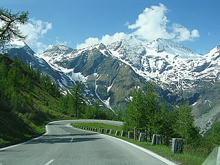
1049:{{Information |Description=Spectacular views on the Grossglocker road. |Source= |Date=2007-05-20 17:52 |Author= from Gou
927:
893:
865:
806:
700:
645:
619:
604:
589:
1296:
70:
850:
835:
772:
736:
674:
562:
526:
872:
1332:
If the file has been modified from its original state, some details may not fully reflect the modified file.
1271:
1091:
251:
842:
248:
1306:
110:
977:
596:
611:
1246:
1141:
1106:
1031:
1026:
165:
61:
42:
335:
329:
215:
1042:
155:
97:
1256:
1216:
1161:
199:
1068:
362:
175:
144:
324:
1131:
1117:
Knowledge:Wiki Loves
Monuments Österreich/Tagdesdenkmals 2018/Salzburg
999:
Click on a date/time to view the file as it appeared at that time.
340:
and was confirmed to be licensed under the terms of the cc-by-2.0.
1186:
886:
201:
350:
184:
85:
873:
https://live.staticflickr.com/1431/580706240_d8421208c6_o.jpg
194:
47° 08′ 02″ N, 12° 48′ 28.5″ E
1126:
1266:
1196:
510:
Add a one-line explanation of what this file represents
1151:
1272:
Seznam krajev
Unescove svetovne dediščine v Avstriji
843:
https://www.flickr.com/photos/sanderovski/580706240/
330:
https://www.flickr.com/photos/22804954@N00/580706240
129:
109:
Commons is a freely licensed media file repository.
75:(1,024 × 768 pixels, file size: 637 KB, MIME type:
90:
234:
8:
1142:Anexo:Patrimonio de la Humanidad en Austria
295:https://creativecommons.org/licenses/by/2.0
271:– to copy, distribute and transmit the work
1334:
1001:
612:https://www.flickr.com/people/22804954@N00
506:
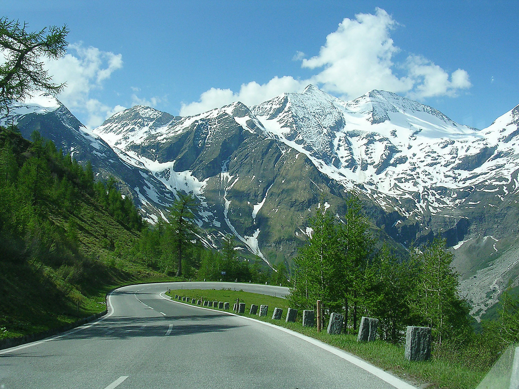
1247:UNESCO Pasaules mantojuma vietas Austrijā
1084:The following other wikis use this file:
1107:Patrimoniu de la Humanidá n'Austria
753:Creative Commons Attribution 2.0 Generic
1336:
1074:List of World Heritage Sites in Austria
1061:
975:
959:
941:
925:
907:
891:
820:
804:
786:
770:
750:
734:
714:
698:
659:
643:
576:
560:
540:
524:
521:
502:
495:
187:
208:View this and other nearby images on:
1059:The following 3 pages use this file:
332:. It was reviewed on 19 June 2010 by
7:
1097:قائمة مواقع التراث العالمي في النمسا
322:This image was originally posted to
311:
990:
240:
1327:
515:
509:
262:
231:
122:
68:
1287:Природоохоронні території Австрії
514:
301:Creative Commons Attribution 2.0
1297:Danh sách di sản thế giới tại Áo
894:coordinates of the point of view
500:
315:
282:Under the following conditions:
247:This file is licensed under the
239:
233:
214:
200:
89:
31:
21:
1162:Grossglockneri kõrgalpi maantee
497:
363:View the annotations at Commons
14:
1064:Grossglockner High Alpine Road
823:file available on the internet
543:Grossglockner High Alpine Road
496:
328:by sanderovski & linda at
141:Grossglockner High Alpine Road
26:
1:
36:
1257:Großglockner-Hochalpenstraße
1217:Großglockner-Hochalpenstraße
909:47°8'2.000"N, 12°48'28.501"E
522:Items portrayed in this file
1148:Usage on es.wikivoyage.org
1123:Usage on en.wikivoyage.org
1103:Usage on ast.wikipedia.org
1358:
1303:Usage on zh.wikipedia.org
1293:Usage on vi.wikipedia.org
1278:Usage on uk.wikipedia.org
1263:Usage on sl.wikipedia.org
1253:Usage on pl.wikipedia.org
1243:Usage on lv.wikipedia.org
1223:Usage on ja.wikipedia.org
1213:Usage on it.wikipedia.org
1203:Usage on hy.wikipedia.org
1193:Usage on hu.wikipedia.org
1183:Usage on fr.wikipedia.org
1172:فهرست میراث جهانی در اتریش
1168:Usage on fa.wikipedia.org
1158:Usage on et.wikipedia.org
1138:Usage on es.wikipedia.org
1113:Usage on de.wikipedia.org
1088:Usage on ar.wikipedia.org
1132:Hohe Tauern National Park
991:
360:This image is annotated:
139:Spectacular views on the
16:
1237:利用者:ロイヤルオーク/sandbox/下書き5
1177:جاده کوهستانی گروسگلاکنر
499:
96:This is a file from the
1048:
252:Attribution 2.0 Generic
171:
161:
154:
151:
132:
100:. Information from its
1207:Տրանսպորտն Ավստրիայում
220:47.133889; 12.807917
135:Grossglockner road.jpg
103:description page there
46:Size of this preview:
466:Schartenkopf (2857m)
1187:Tourisme en Autriche
147:. Looking the south.
1027:22:18, 18 June 2010
416:Sinwelleck (3261m)
277:– to adapt the work
178:from Gouda, Holland
52:Other resolutions:
626:Sander Hoogendoorn
620:author name string
441:Kapuziner (2852m)
259:Sander Hoogendoorn
176:Sander Hoogendoorn
166:Grossglockner road
156:20 May 2007, 17:52
62:1,024 × 768 pixels
1345:
1344:
1080:Global file usage
1052:
737:copyright license
508:
369:
368:
344:
343:
225:
224:
182:
181:
118:
117:
98:Wikimedia Commons
32:Global file usage
1349:
1335:
1039:
962:Flickr photo ID
875:
870:
860:
855:
845:
840:
836:described at URL
701:copyright status
682:
679:
675:publication date
627:
624:
614:
609:
599:
594:
491:Äußeres Bockkar
351:
348:
338:
319:
318:
312:
308:
305:
302:
299:
296:
260:
249:Creative Commons
243:
242:
237:
236:
221:
218:
204:
203:
197:
196:
185:
157:
136:
130:
114:
93:
92:
86:
80:
78:
65:
58:640 × 480 pixels
54:320 × 240 pixels
48:800 × 600 pixels
1357:
1356:
1352:
1351:
1350:
1348:
1347:
1346:
1323:
1078:
1053:
1045:
1037:
993:
992:
989:
988:
987:
986:
985:
984:
983:
982:
980:
968:
967:
966:
964:
953:
952:
951:
950:
949:
948:
947:
946:
944:
934:
933:
932:
930:
919:
918:
917:
916:
915:
914:
913:
912:
910:
900:
899:
898:
896:
885:
884:
883:
882:
881:
880:
879:
878:
877:
876:
871:
868:
862:
861:
856:
853:
847:
846:
841:
838:
829:
828:
827:
825:
813:
812:
811:
809:
798:
797:
796:
795:
794:
793:
792:
791:
789:
779:
778:
777:
775:
764:
763:
762:
761:
760:
759:
758:
757:
755:
743:
742:
741:
739:
728:
727:
726:
725:
724:
723:
722:
721:
719:
707:
706:
705:
703:
692:
691:
690:
689:
688:
687:
686:
685:
684:
683:
680:
677:
668:
667:
666:
664:
652:
651:
650:
648:
637:
636:
635:
634:
633:
632:
631:
630:
629:
628:
625:
622:
616:
615:
610:
607:
601:
600:
595:
592:
583:
582:
581:
579:
569:
568:
567:
565:
554:
553:
552:
551:
550:
549:
548:
547:
545:
533:
532:
531:
529:
513:
512:
511:
494:
493:
488:
485:
482:
479:
476:
473:
469:
468:
463:
460:
457:
454:
451:
448:
444:
443:
438:
435:
432:
429:
426:
423:
419:
418:
413:
410:
407:
404:
401:
398:
394:
393:
391:Fuscherkarkopf
388:
385:
382:
379:
376:
373:
357:
346:
334:
316:
310:
309:
306:
303:
300:
297:
294:
293:
261:
258:
255:
244:
230:
219:
192:
191:
188:Camera location
183:
134:
127:
120:
119:
108:
107:
106:is shown below.
82:
76:
74:
67:
66:
51:
12:
11:
5:
1355:
1353:
1343:
1342:
1339:
1326:
1322:
1321:
1320:
1319:
1314:
1309:
1301:
1300:
1299:
1291:
1290:
1289:
1284:
1282:Високий Тауерн
1276:
1275:
1274:
1269:
1261:
1260:
1259:
1251:
1250:
1249:
1241:
1240:
1239:
1234:
1229:
1227:グロースグロックナー山岳道路
1221:
1220:
1219:
1211:
1210:
1209:
1201:
1200:
1199:
1191:
1190:
1189:
1181:
1180:
1179:
1174:
1166:
1165:
1164:
1156:
1155:
1154:
1146:
1145:
1144:
1136:
1135:
1134:
1129:
1121:
1120:
1119:
1111:
1110:
1109:
1101:
1100:
1099:
1094:
1082:
1081:
1077:
1076:
1071:
1066:
1057:
1056:
1051:
1050:
1047:
1043:
1040:
1034:
1029:
1024:
1020:
1019:
1016:
1013:
1010:
1007:
1004:
997:
996:
981:
976:
974:
973:
972:
971:
970:
969:
965:
960:
958:
957:
956:
955:
954:
945:
942:
940:
939:
938:
937:
936:
935:
931:
926:
924:
923:
922:
921:
920:
911:
908:
906:
905:
904:
903:
902:
901:
897:
892:
890:
889:
888:
887:
864:
863:
849:
848:
834:
833:
832:
831:
830:
826:
821:
819:
818:
817:
816:
815:
814:
810:
807:source of file
805:
803:
802:
801:
800:
799:
790:
787:
785:
784:
783:
782:
781:
780:
776:
771:
769:
768:
767:
766:
765:
756:
751:
749:
748:
747:
746:
745:
744:
740:
735:
733:
732:
731:
730:
729:
720:
715:
713:
712:
711:
710:
709:
708:
704:
699:
697:
696:
695:
694:
693:
673:
672:
671:
670:
669:
665:
660:
658:
657:
656:
655:
654:
653:
649:
644:
642:
641:
640:
639:
638:
618:
617:
603:
602:
590:Flickr user ID
588:
587:
586:
585:
584:
580:
577:
575:
574:
573:
572:
571:
570:
566:
561:
559:
558:
557:
556:
555:
546:
541:
539:
538:
537:
536:
535:
534:
530:
525:
523:
520:
519:
518:
517:
516:
505:
504:
501:
498:
489:
486:
483:
480:
477:
474:
471:
470:
464:
461:
458:
455:
452:
449:
446:
445:
439:
436:
433:
430:
427:
424:
421:
420:
414:
411:
408:
405:
402:
399:
396:
395:
389:
386:
383:
380:
377:
374:
371:
370:
367:
366:
358:
355:
342:
341:
320:
292:
291:
290:
289:
280:
279:
278:
272:
265:You are free:
256:
246:
245:
232:
229:
226:
223:
222:
212:
206:
189:
180:
179:
173:
169:
168:
163:
159:
158:
153:
149:
148:
137:
128:
126:
123:
121:
116:
115:
94:
84:
83:
45:
41:
40:
39:
34:
29:
24:
19:
13:
10:
9:
6:
4:
3:
2:
1354:
1340:
1337:
1333:
1330:
1324:
1318:
1315:
1313:
1312:大格洛克纳阿尔卑斯高山公路
1310:
1308:
1305:
1304:
1302:
1298:
1295:
1294:
1292:
1288:
1285:
1283:
1280:
1279:
1277:
1273:
1270:
1268:
1265:
1264:
1262:
1258:
1255:
1254:
1252:
1248:
1245:
1244:
1242:
1238:
1235:
1233:
1230:
1228:
1225:
1224:
1222:
1218:
1215:
1214:
1212:
1208:
1205:
1204:
1202:
1198:
1195:
1194:
1192:
1188:
1185:
1184:
1182:
1178:
1175:
1173:
1170:
1169:
1167:
1163:
1160:
1159:
1157:
1153:
1150:
1149:
1147:
1143:
1140:
1139:
1137:
1133:
1130:
1128:
1125:
1124:
1122:
1118:
1115:
1114:
1112:
1108:
1105:
1104:
1102:
1098:
1095:
1093:
1090:
1089:
1087:
1086:
1085:
1079:
1075:
1072:
1070:
1067:
1065:
1062:
1060:
1054:
1046:
1041:
1035:
1033:
1030:
1028:
1025:
1022:
1021:
1017:
1014:
1011:
1008:
1005:
1003:
1002:
1000:
994:
979:
963:
929:
895:
874:
867:
859:
852:
844:
837:
824:
808:
774:
754:
738:
718:
702:
676:
663:
647:
621:
613:
606:
598:
591:
564:
544:
528:
492:
467:
442:
417:
392:
365:
364:
359:
353:
352:
349:
339:
337:
331:
327:
326:
321:
314:
313:
287:
284:
283:
281:
276:
273:
270:
267:
266:
264:
263:
257:Attribution:
253:
250:
238:
227:
217:
213:
211:
210:OpenStreetMap
207:
205:
195:
190:
186:
177:
174:
170:
167:
164:
160:
150:
146:
142:
138:
131:
124:
112:
105:
104:
99:
95:
88:
87:
81:
72:
71:Original file
63:
59:
55:
49:
44:
38:
35:
33:
30:
28:
25:
23:
20:
18:
15:
1331:
1328:
1267:Zahodne Ture
1197:Magas-Tauern
1127:Heiligenblut
1083:
1058:
1036:1,024 × 768
998:
995:File history
681:21 June 2007
646:published in
597:22804954@N00
490:
465:
440:
415:
390:
361:
347:19 June 2010
345:
336:FlickreviewR
333:
323:
285:
274:
268:
111:You can help
101:
69:
22:File history
1232:第43回世界遺産委員会
1069:High Tauern
788:20 May 2007
717:copyrighted
354:Annotations
286:attribution
133:Description
1338:_error
1092:غروسغلوكنر
1055:File usage
1012:Dimensions
943:image/jpeg
928:media type
578:some value
298:CC BY 2.0
77:image/jpeg
27:File usage
1317:奥地利世界遗产名录
1009:Thumbnail
1006:Date/Time
978:580706240
773:inception
356:InfoField
228:Licensing
1325:Metadata
1044:Blue Elf
1038:(637 KB)
851:operator
503:Captions
275:to remix
269:to share
254:license.
37:Metadata
1152:Austria
1023:current
1018:Comment
563:creator
527:depicts
507:English
145:Austria
125:Summary
73:
1307:高地陶恩山脈
858:Flickr
662:Flickr
325:Flickr
198:
172:Author
162:Source
1015:User
484:1024
459:1024
434:1024
409:1024
384:1024
307:true
304:true
152:Date
17:File
866:URL
605:URL
487:768
478:158
475:312
472:616
462:768
450:198
447:243
437:768
425:187
422:445
412:768
400:147
397:570
387:768
381:146
378:205
375:146
372:704
143:in
869::
854::
839::
678::
623::
608::
593::
481:96
456:24
453:66
431:35
428:48
406:96
403:98
60:|
56:|
50:.
1341:0
113:.
79:)
64:.
Text is available under the Creative Commons Attribution-ShareAlike License. Additional terms may apply.