290:
223:
237:
258:
296:
301:
72:
774:
214:
43:
348:– You must give appropriate credit, provide a link to the license, and indicate if changes were made. You may do so in any reasonable manner, but not in any way that suggests the licensor endorses you or your use.
791:== {{int:filedesc}} == {{Information |description={{en|1=Gwynfe Church. The old church is right next to the new community centre.}} |date=2006-04-02 |source=From |author=[http://www.geograph.org.uk
83:
51:
634:
564:
528:
230:
126:
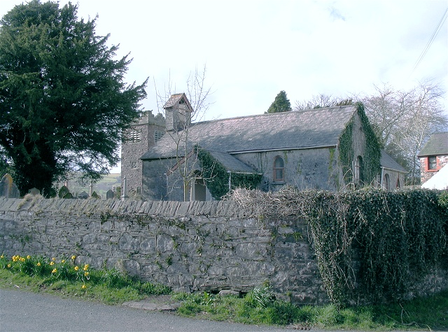
Former church, Gwynfe, Carmarthenshire. The tower of its replacement, Christ Church, is visible immediately left of the church.
654:
265:
866:
This file contains additional information, probably added from the digital camera or scanner used to create or digitize it.
355:
491:
705:
662:
618:
512:
484:
471:
456:
677:
647:
584:
548:
429:
412:
252:
773:
768:
311:
42:
869:
If the file has been modified from its original state, some details may not fully reflect the modified file.
354:– If you remix, transform, or build upon the material, you must distribute your contributions under the
272:
on the
Geograph website for the photographer's contact details. The copyright on this image is owned by
784:
308:
91:
183:
684:
669:
167:
463:
236:
277:
78:
135:
220:
146:
156:
257:
805:
269:
741:
Click on a date/time to view the file as it appeared at that time.
222:
205:
66:
698:
843:
833:
823:
215:
51° 52′ 57″ N, 3° 51′ 22″ W
396:
Add a one-line explanation of what this file represents
853:
110:
90:
Commons is a freely licensed media file repository.
565:
Creative
Commons Attribution-ShareAlike 2.0 Generic
56:(640 × 475 pixels, file size: 173 KB, MIME type:
365:https://creativecommons.org/licenses/by-sa/2.0
71:
371:Creative Commons Attribution-Share Alike 2.0
289:
8:
116:Gwynfe Church - geograph.org.uk - 145852.jpg
52:Gwynfe_Church_-_geograph.org.uk_-_145852.jpg
331:– to copy, distribute and transmit the work
871:
743:
392:
816:The following other wikis use this file:
685:https://www.geograph.org.uk/photo/145852
873:
803:
719:
703:
632:
616:
598:
582:
562:
546:
526:
510:
464:https://www.geograph.org.uk/profile/860
443:
427:
410:
407:
388:
381:
208:
229:View this and other nearby images on:
7:
276:and is licensed for reuse under the
801:The following page uses this file:
732:
312:Attribution-Share Alike 2.0 Generic
300:
295:
280:Attribution-ShareAlike 2.0 license.
864:
401:
395:
286:
263:
120:
103:
49:
400:
386:
342:Under the following conditions:
307:This file is licensed under the
299:
294:
288:
256:
235:
221:
70:
31:
21:
383:
121:
46:No higher resolution available.
14:
635:file available on the internet
382:
264:This image was taken from the
26:
1:
706:coordinates of depicted place
36:
655:Geograph Britain and Ireland
485:object of statement has role
408:Items portrayed in this file
895:
850:Usage on www.wikidata.org
840:Usage on ga.wikipedia.org
830:Usage on eu.wikipedia.org
820:Usage on cy.wikipedia.org
356:same or compatible license
733:
721:51°52'56.6"N, 3°51'21.6"W
196:Nigel Davies /
177:Nigel Davies /
16:
663:geograph.org.uk image ID
385:
322:
77:This is a file from the
790:
168:required by the license
152:
141:
134:
131:
113:
81:. Information from its
769:07:10, 31 January 2010
270:this photograph's page
241:51.882400; -3.856000
84:description page there
337:– to adapt the work
472:author name string
882:
881:
812:Global file usage
794:
549:copyright license
394:
285:
284:
268:collection. See
246:
245:
203:
202:
171:
99:
98:
79:Wikimedia Commons
32:Global file usage
886:
872:
781:
687:
682:
678:described at URL
672:
667:
657:
652:
513:copyright status
494:
489:
479:
476:
466:
461:
378:
375:
372:
369:
366:
358:as the original.
320:
309:Creative Commons
303:
302:
298:
297:
292:
291:
278:Creative Commons
266:Geograph project
260:
253:
242:
239:
225:
224:
218:
217:
206:
165:
137:
125:
117:
111:
95:
74:
73:
67:
61:
59:
894:
893:
889:
888:
887:
885:
884:
883:
860:
810:
795:
787:
779:
735:
734:
731:
730:
729:
728:
727:
726:
725:
724:
722:
712:
711:
710:
708:
697:
696:
695:
694:
693:
692:
691:
690:
689:
688:
683:
680:
674:
673:
668:
665:
659:
658:
653:
650:
641:
640:
639:
637:
625:
624:
623:
621:
610:
609:
608:
607:
606:
605:
604:
603:
601:
591:
590:
589:
587:
576:
575:
574:
573:
572:
571:
570:
569:
567:
555:
554:
553:
551:
540:
539:
538:
537:
536:
535:
534:
533:
531:
519:
518:
517:
515:
504:
503:
502:
501:
500:
499:
498:
497:
496:
495:
490:
487:
481:
480:
477:
474:
468:
467:
462:
459:
450:
449:
448:
446:
436:
435:
434:
432:
421:
420:
419:
418:
417:
415:
399:
398:
397:
380:
379:
376:
373:
370:
367:
364:
363:
321:
318:
315:
304:
281:
251:
240:
213:
212:
209:Object location
204:
193:
186:
174:
147:geograph.org.uk
127:
115:
108:
101:
100:
89:
88:
87:is shown below.
63:
57:
55:
48:
47:
12:
11:
5:
892:
890:
880:
879:
876:
863:
859:
858:
857:
856:
848:
847:
846:
838:
837:
836:
828:
827:
826:
814:
813:
809:
808:
799:
798:
793:
792:
789:
785:
782:
776:
771:
766:
762:
761:
758:
755:
752:
749:
746:
739:
738:
723:
720:
718:
717:
716:
715:
714:
713:
709:
704:
702:
701:
700:
699:
676:
675:
661:
660:
646:
645:
644:
643:
642:
638:
633:
631:
630:
629:
628:
627:
626:
622:
619:source of file
617:
615:
614:
613:
612:
611:
602:
599:
597:
596:
595:
594:
593:
592:
588:
583:
581:
580:
579:
578:
577:
568:
563:
561:
560:
559:
558:
557:
556:
552:
547:
545:
544:
543:
542:
541:
532:
527:
525:
524:
523:
522:
521:
520:
516:
511:
509:
508:
507:
506:
505:
483:
482:
470:
469:
455:
454:
453:
452:
451:
447:
444:
442:
441:
440:
439:
438:
437:
433:
428:
426:
425:
424:
423:
422:
416:
411:
409:
406:
405:
404:
403:
402:
391:
390:
387:
384:
362:
361:
360:
359:
349:
340:
339:
338:
332:
325:You are free:
316:
306:
305:
287:
283:
282:
261:
250:
247:
244:
243:
233:
227:
210:
201:
200:
194:
191:
188:
187:
182:
175:
172:
160:
159:
154:
150:
149:
143:
139:
138:
133:
129:
128:
118:
109:
107:
104:
102:
97:
96:
75:
65:
64:
45:
41:
40:
39:
34:
29:
24:
19:
13:
10:
9:
6:
4:
3:
2:
891:
877:
874:
870:
867:
861:
855:
852:
851:
849:
845:
842:
841:
839:
835:
832:
831:
829:
825:
822:
821:
819:
818:
817:
811:
807:
804:
802:
796:
788:
783:
777:
775:
772:
770:
767:
764:
763:
759:
756:
753:
750:
747:
745:
744:
742:
736:
707:
686:
679:
671:
664:
656:
649:
636:
620:
586:
566:
550:
530:
514:
493:
486:
473:
465:
458:
431:
414:
368:CC BY-SA 2.0
357:
353:
350:
347:
344:
343:
341:
336:
333:
330:
327:
326:
324:
323:
317:Attribution:
313:
310:
293:
279:
275:
271:
267:
262:
259:
255:
254:
248:
238:
234:
232:
231:OpenStreetMap
228:
226:
216:
211:
207:
199:
198:Gwynfe Church
195:
190:
189:
185:
181: /
180:
179:Gwynfe Church
176:
169:
164:
162:
161:
158:
155:
151:
148:
144:
140:
130:
124:
119:
112:
105:
93:
86:
85:
80:
76:
69:
68:
62:
53:
44:
38:
35:
33:
30:
28:
25:
23:
20:
18:
15:
868:
865:
844:Capel Gwynfe
834:Capel Gwynfe
824:Capel Gwynfe
815:
800:
740:
737:File history
600:2 April 2006
492:photographer
478:Nigel Davies
351:
345:
334:
328:
319:Nigel Davies
274:Nigel Davies
273:
197:
184:CC BY-SA 2.0
178:
157:Nigel Davies
136:2 April 2006
122:
92:You can help
82:
50:
22:File history
786:GeographBot
529:copyrighted
352:share alike
346:attribution
163:Attribution
114:Description
875:_error
797:File usage
778:640 × 475
754:Dimensions
445:some value
58:image/jpeg
27:File usage
854:Q13128899
751:Thumbnail
748:Date/Time
585:inception
249:Licensing
192:InfoField
173:InfoField
123:English:
862:Metadata
780:(173 KB)
648:operator
389:Captions
335:to remix
329:to share
314:license.
37:Metadata
765:current
760:Comment
430:creator
413:depicts
393:English
106:Summary
54:
806:Gwynfe
670:145852
219:
153:Author
142:Source
145:From
757:User
377:true
374:true
132:Date
17:File
457:URL
681::
666::
651::
488::
475::
460::
878:0
170:)
166:(
94:.
60:)
Text is available under the Creative Commons Attribution-ShareAlike License. Additional terms may apply.
_&language=en)
