250:
211:
225:
256:
110:
105:
67:
644:
297:– You must give appropriate credit, provide a link to the license, and indicate if changes were made. You may do so in any reasonable manner, but not in any way that suggests the licensor endorses you or your use.
202:
38:
689:
185:
684:
555:
519:
483:
218:
78:
418:
46:
575:
539:
467:
439:
426:
411:
396:
503:
369:
352:
127:
732:
117:
403:
675:
The following pages on the
English Knowledge (XXG) use this file (pages on other projects are not listed):
661:{{Information |Description={{da|1=Gyldenholms hovedbygning set fra gårdspladsen}} |Source={{own}} |Author=
266:
263:
722:
86:
662:
654:
446:
643:
638:
37:
717:
224:
73:
243:
I, the copyright holder of this work, hereby publish it under the following license:
727:
712:
208:
122:
679:
733:
Bruger:Fnielsen/Autolister/Bygninger med
Fredede bygningers sagsnummer
99:
611:
Click on a date/time to view the file as it appeared at that time.
568:
210:
203:
55° 20′ 26.04″ N, 11° 27′ 45.76″ E
193:
166:
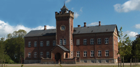
The main building of the mansion
Gyldenholm seen from the yard
61:
707:
336:
Add a one-line explanation of what this file represents
742:
142:
85:
Commons is a freely licensed media file repository.
723:Bruger:Palnatoke/Autolister/Herregårde i Danmark
51:(279 × 134 pixels, file size: 77 KB, MIME type:
66:
249:
158:Gyldenholms hovedbygning set fra gårdspladsen
8:
304:https://creativecommons.org/licenses/by/3.0
280:– to copy, distribute and transmit the work
613:
332:
700:The following other wikis use this file:
690:Listed buildings in Slagelse Municipality
520:Creative Commons Attribution 3.0 Unported
665:|Date= |Permission= |other_versions= }}
677:
589:
573:
553:
537:
517:
501:
481:
465:
447:https://commons.wikimedia.org/User:Neer
383:
367:
350:
347:
328:
321:
196:
718:Bruger:Palnatoke/Autolister/Herregårde
217:View this and other nearby images on:
728:Bruger:Palnatoke/Autolister/Kulturarv
7:
713:Fredede bygninger i Slagelse Kommune
602:
255:
685:List of historic houses in Denmark
341:
335:
271:
246:
242:
160:
152:
125:
115:
98:
44:
340:
310:Creative Commons Attribution 3.0
576:coordinates of the point of view
326:
291:Under the following conditions:
262:This file is licensed under the
254:
248:
223:
209:
108:
103:
65:
31:
21:
323:
161:
41:No higher resolution available.
14:
591:55°20'26.041"N, 11°27'45.760"E
322:
153:
130:database for Listed Buildings.
26:
1:
556:original creation by uploader
412:object of statement has role
348:Items portrayed in this file
761:
739:Usage on www.wikidata.org
704:Usage on da.wikipedia.org
128:Heritage Agency of Denmark
118:listed building in Denmark
603:
175:
16:
639:08:25, 15 September 2010
325:
267:Attribution 3.0 Unported
72:This is a file from the
660:
181:
171:
148:Gykdenholm hovedbyg.png
145:
76:. Information from its
47:Gykdenholm_hovedbyg.png
229:55.340567; 11.462711
79:description page there
116:This is a photo of a
286:– to adapt the work
427:author name string
397:Wikimedia username
696:Global file usage
668:
504:copyright license
334:
234:
233:
191:
190:
135:
134:
94:
93:
74:Wikimedia Commons
32:Global file usage
752:
651:
468:copyright status
449:
444:
434:
431:
421:
416:
406:
401:
317:
314:
311:
308:
305:
264:Creative Commons
258:
257:
252:
251:
230:
227:
213:
212:
206:
205:
194:
177:
165:
157:
149:
143:
112:
111:
107:
106:
100:
90:
69:
68:
62:
56:
54:
760:
759:
755:
754:
753:
751:
750:
749:
694:
676:
669:
657:
649:
605:
604:
601:
600:
599:
598:
597:
596:
595:
594:
592:
582:
581:
580:
578:
567:
566:
565:
564:
563:
562:
561:
560:
558:
546:
545:
544:
542:
531:
530:
529:
528:
527:
526:
525:
524:
522:
510:
509:
508:
506:
495:
494:
493:
492:
491:
490:
489:
488:
486:
474:
473:
472:
470:
459:
458:
457:
456:
455:
454:
453:
452:
451:
450:
445:
442:
436:
435:
432:
429:
423:
422:
417:
414:
408:
407:
402:
399:
390:
389:
388:
386:
376:
375:
374:
372:
361:
360:
359:
358:
357:
355:
339:
338:
337:
320:
319:
318:
315:
312:
309:
306:
303:
302:
270:
259:
245:
244:
239:
228:
201:
200:
197:Camera location
192:
167:
159:
147:
140:
131:
121:
109:
104:
96:
95:
84:
83:
82:is shown below.
58:
52:
50:
43:
42:
12:
11:
5:
758:
756:
748:
747:
746:
745:
737:
736:
735:
730:
725:
720:
715:
710:
698:
697:
693:
692:
687:
682:
674:
673:
672:
667:
666:
659:
655:
652:
646:
641:
636:
632:
631:
628:
625:
622:
619:
616:
609:
608:
593:
590:
588:
587:
586:
585:
584:
583:
579:
574:
572:
571:
570:
569:
559:
554:
552:
551:
550:
549:
548:
547:
543:
540:source of file
538:
536:
535:
534:
533:
532:
523:
518:
516:
515:
514:
513:
512:
511:
507:
502:
500:
499:
498:
497:
496:
487:
482:
480:
479:
478:
477:
476:
475:
471:
466:
464:
463:
462:
461:
460:
438:
437:
425:
424:
410:
409:
395:
394:
393:
392:
391:
387:
384:
382:
381:
380:
379:
378:
377:
373:
368:
366:
365:
364:
363:
362:
356:
351:
349:
346:
345:
344:
343:
342:
331:
330:
327:
324:
301:
300:
299:
298:
289:
288:
287:
281:
274:You are free:
261:
260:
247:
241:
240:
238:
235:
232:
231:
221:
215:
198:
189:
188:
183:
179:
178:
173:
169:
168:
150:
141:
139:
136:
133:
132:
113:
97:
92:
91:
70:
60:
59:
40:
36:
35:
34:
29:
24:
19:
13:
10:
9:
6:
4:
3:
2:
757:
744:
741:
740:
738:
734:
731:
729:
726:
724:
721:
719:
716:
714:
711:
709:
706:
705:
703:
702:
701:
695:
691:
688:
686:
683:
681:
678:
670:
664:
658:
653:
647:
645:
642:
640:
637:
634:
633:
629:
626:
623:
620:
617:
615:
614:
612:
606:
577:
557:
541:
521:
505:
485:
469:
448:
441:
428:
420:
413:
405:
398:
371:
354:
296:
293:
292:
290:
285:
282:
279:
276:
275:
273:
272:
268:
265:
253:
236:
226:
222:
220:
219:OpenStreetMap
216:
214:
204:
199:
195:
187:
184:
180:
174:
170:
164:
156:
151:
144:
137:
129:
124:
119:
114:
102:
101:
88:
81:
80:
75:
71:
64:
63:
57:
48:
39:
33:
30:
28:
25:
23:
20:
18:
15:
699:
610:
607:File history
419:photographer
294:
283:
277:
162:
154:
87:You can help
77:
45:
22:File history
484:copyrighted
295:attribution
146:Description
708:Gyldenholm
680:Gyldenholm
671:File usage
648:279 × 134
624:Dimensions
385:some value
307:CC BY 3.0
27:File usage
743:Q12059305
621:Thumbnail
618:Date/Time
237:Licensing
163:English:
123:330-470-1
53:image/png
329:Captions
284:to remix
278:to share
269:license.
176:Own work
120:, number
650:(77 KB)
635:current
630:Comment
370:creator
353:depicts
333:English
155:Dansk:
138:Summary
126:in the
49:
207:
182:Author
172:Source
663:Neer
656:Neer
627:User
433:Neer
404:Neer
316:true
313:true
186:Neer
17:File
440:URL
443::
430::
415::
400::
89:.
55:)
Text is available under the Creative Commons Attribution-ShareAlike License. Additional terms may apply.