43:
249:
210:
224:
255:
260:
103:
711:
301:– You must give appropriate credit, provide a link to the license, and indicate if changes were made. You may do so in any reasonable manner, but not in any way that suggests the licensor endorses you or your use.
201:
157:(von links nach rechts) Die Schauenburg, die 3 ehemaligen Steinbrüche Ölberg, Steinbruch Vadder, Steinbruch Leferenz und der Hohe Nistler (496 m). Dossenheim Luftbild von Westen.
69:
65:
61:
57:
53:
47:
184:
114:
82:
622:
518:
482:
217:
1143:
958:
This file contains additional information, probably added from the digital camera or scanner used to create or digitize it.
308:
417:
642:
606:
572:
466:
438:
425:
410:
538:
502:
383:
366:
445:
270:
961:
If the file has been modified from its original state, some details may not fully reflect the modified file.
905:
885:
770:
1199:
307:– If you remix, transform, or build upon the material, you must distribute your contributions under the
267:
710:
705:
73:
42:
1243:
895:
721:
122:
1112:
1337:
223:
1303:
1225:
1003:
109:
242:
I, the copyright holder of this work, hereby publish it under the following license:
1347:
1043:
1261:
207:
1023:
742:
1357:
1013:
760:
678:
Click on a date/time to view the file as it appeared at that time.
988:
565:
209:
202:
49° 26′ 47.49″ N, 8° 39′ 51.27″ E
978:
192:
97:
790:
519:
Creative
Commons Attribution-ShareAlike 4.0 International
855:
845:
795:
935:
925:
915:
875:
865:
835:
825:
815:
805:
780:
350:
Add a one-line explanation of what this file represents
87:(4,000 × 2,250 pixels, file size: 3.32 MB, MIME type:
141:
121:
Commons is a freely licensed media file repository.
945:
318:https://creativecommons.org/licenses/by-sa/4.0
102:
324:Creative Commons Attribution-Share Alike 4.0
248:
8:
284:– to copy, distribute and transmit the work
963:
680:
346:
753:The following other wikis use this file:
271:Attribution-Share Alike 4.0 International
1389:
1381:
1373:
1365:
1355:
1345:
1335:
1327:
1319:
1311:
1301:
1293:
1285:
1277:
1269:
1259:
1251:
1241:
1233:
1223:
1215:
1207:
1197:
1189:
1181:
1160:
1152:
1141:
1133:
1125:
1117:
1107:
1099:
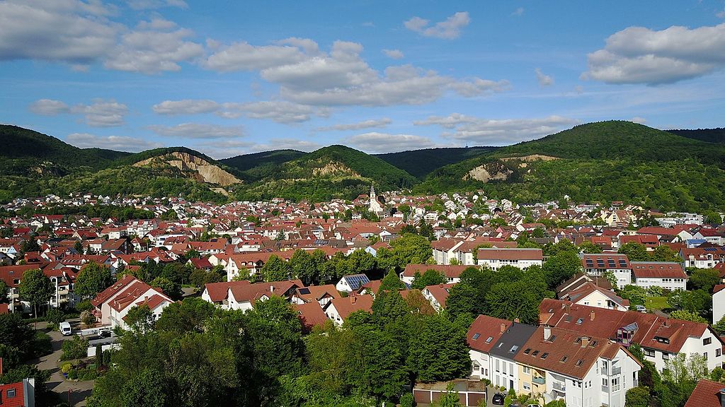
1091:
1083:
1075:
1067:
1059:
1051:
1040:
1032:
1021:
1011:
1001:
993:
983:
965:
740:
656:
640:
620:
604:
586:
570:
552:
536:
516:
500:
480:
464:
397:
381:
364:
361:
342:
335:
195:
216:View this and other nearby images on:
1248:Flash did not fire, No flash function
973:
7:
738:The following page uses this file:
728:User created page with UploadWizard
669:
259:
254:
166:Taken on 21 May 2017, 17:42:30
956:
355:
349:
245:
241:
151:
147:Dossenheim Luftbild von Westen.jpg
134:
80:
354:
1378:e7768521f62ce2435bb7a2d00ae0b43d
1034:Date and time of data generation
573:coordinates of the point of view
340:
295:Under the following conditions:
266:This file is licensed under the
258:
253:
247:
222:
208:
101:
31:
21:
337:
14:
336:
152:
26:
1:
1282:A directly photographed image
1072:44.832 meters above sea level
623:original creation by uploader
588:49°26'47.494"N, 8°39'51.268"E
36:
1008:501/1,000,000 sec (0.000501)
411:object of statement has role
362:Items portrayed in this file
1154:Date and time of digitizing
852:Usage on lmo.wikipedia.org
842:Usage on lld.wikipedia.org
787:Usage on de.wikivoyage.org
757:Usage on ceb.wikipedia.org
1411:
1313:Focal length in 35 mm film
1253:Supported Flashpix version
970:DCIM\100MEDIA\DJI_0002.JPG
942:Usage on www.wikidata.org
932:Usage on vo.wikipedia.org
922:Usage on vi.wikipedia.org
912:Usage on uz.wikipedia.org
902:Usage on tt.wikipedia.org
892:Usage on sr.wikipedia.org
882:Usage on ru.wikipedia.org
872:Usage on ro.wikipedia.org
862:Usage on pl.wikipedia.org
832:Usage on ku.wikipedia.org
822:Usage on it.wikipedia.org
812:Usage on hu.wikipedia.org
802:Usage on es.wikipedia.org
777:Usage on de.wikipedia.org
767:Usage on ce.wikipedia.org
309:same or compatible license
1162:Meaning of each component
1119:File change date and time
670:
174:
16:
339:
275:
108:This is a file from the
1287:Custom image processing
1230:Center weighted average
727:
180:
170:
165:
162:
144:
112:. Information from its
1367:Subject distance range
1183:Image compression mode
761:Dossenheim (munisipyo)
228:49.446526; 8.664241
115:description page there
46:Size of this preview:
1209:Maximum land aperture
1093:Horizontal resolution
1274:Digital still camera
74:4,000 × 2,250 pixels
70:2,560 × 1,440 pixels
1127:Y and C positioning
1101:Vertical resolution
975:Camera manufacturer
290:– to adapt the work
52:Other resolutions:
1321:Scene capture type
1308:Auto white balance
1157:17:42, 21 May 2017
1122:20:47, 21 May 2017
1037:17:42, 21 May 2017
706:18:49, 21 May 2017
439:Wikimedia username
426:author name string
66:1,280 × 720 pixels
62:1,024 × 576 pixels
1398:
1397:
1212:2.27 APEX (f/2.2)
749:Global file usage
731:
503:copyright license
348:
233:
232:
190:
189:
130:
129:
110:Wikimedia Commons
32:Global file usage
1402:
1217:Subject distance
1135:Exposure Program
1056:49° 26′ 47.49″ N
964:
718:
467:copyright status
448:
443:
433:
430:
420:
415:
331:
328:
325:
322:
319:
311:as the original.
268:Creative Commons
262:
261:
257:
256:
251:
250:
229:
226:
212:
211:
205:
204:
193:
176:
156:
148:
142:
126:
105:
104:
98:
92:
90:
77:
58:640 × 360 pixels
54:320 × 180 pixels
48:800 × 450 pixels
1410:
1409:
1405:
1404:
1403:
1401:
1400:
1399:
1383:GPS tag version
1375:Unique image ID
1186:3.1266284444444
1064:8° 39′ 51.27″ E
952:
747:
732:
724:
716:
672:
671:
668:
667:
666:
665:
664:
663:
662:
661:
659:
649:
648:
647:
645:
634:
633:
632:
631:
630:
629:
628:
627:
625:
613:
612:
611:
609:
598:
597:
596:
595:
594:
593:
592:
591:
589:
579:
578:
577:
575:
564:
563:
562:
561:
560:
559:
558:
557:
555:
545:
544:
543:
541:
530:
529:
528:
527:
526:
525:
524:
523:
521:
509:
508:
507:
505:
494:
493:
492:
491:
490:
489:
488:
487:
485:
473:
472:
471:
469:
458:
457:
456:
455:
454:
453:
452:
451:
450:
449:
444:
441:
435:
434:
431:
428:
422:
421:
416:
413:
404:
403:
402:
400:
390:
389:
388:
386:
375:
374:
373:
372:
371:
369:
353:
352:
351:
334:
333:
332:
329:
326:
323:
320:
317:
316:
274:
263:
244:
243:
238:
227:
200:
199:
196:Camera location
191:
158:
146:
139:
132:
131:
120:
119:
118:is shown below.
94:
88:
86:
79:
78:
51:
12:
11:
5:
1408:
1406:
1396:
1395:
1392:
1388:
1387:
1384:
1380:
1379:
1376:
1372:
1371:
1368:
1364:
1363:
1360:
1354:
1353:
1350:
1344:
1343:
1340:
1334:
1333:
1330:
1326:
1325:
1322:
1318:
1317:
1314:
1310:
1309:
1306:
1300:
1299:
1296:
1292:
1291:
1290:Normal process
1288:
1284:
1283:
1280:
1276:
1275:
1272:
1268:
1267:
1264:
1258:
1257:
1254:
1250:
1249:
1246:
1240:
1239:
1236:
1232:
1231:
1228:
1222:
1221:
1218:
1214:
1213:
1210:
1206:
1205:
1202:
1196:
1195:
1192:
1188:
1187:
1184:
1180:
1179:
1178:
1177:
1174:
1171:
1168:
1167:does not exist
1163:
1159:
1158:
1155:
1151:
1150:
1147:
1140:
1139:
1138:Normal program
1136:
1132:
1131:
1128:
1124:
1123:
1120:
1116:
1115:
1110:
1106:
1105:
1102:
1098:
1097:
1094:
1090:
1089:
1086:
1082:
1081:
1078:
1074:
1073:
1070:
1066:
1065:
1062:
1058:
1057:
1054:
1050:
1049:
1046:
1039:
1038:
1035:
1031:
1030:
1027:
1020:
1019:
1016:
1010:
1009:
1006:
1000:
999:
996:
992:
991:
986:
982:
981:
976:
972:
971:
968:
955:
951:
950:
949:
948:
940:
939:
938:
930:
929:
928:
920:
919:
918:
910:
909:
908:
900:
899:
898:
890:
889:
888:
880:
879:
878:
870:
869:
868:
860:
859:
858:
850:
849:
848:
840:
839:
838:
830:
829:
828:
820:
819:
818:
810:
809:
808:
800:
799:
798:
793:
785:
784:
783:
775:
774:
773:
765:
764:
763:
751:
750:
746:
745:
736:
735:
730:
729:
726:
722:
719:
715:4,000 × 2,250
713:
708:
703:
699:
698:
695:
692:
689:
686:
683:
676:
675:
660:
657:
655:
654:
653:
652:
651:
650:
646:
641:
639:
638:
637:
636:
635:
626:
621:
619:
618:
617:
616:
615:
614:
610:
607:source of file
605:
603:
602:
601:
600:
599:
590:
587:
585:
584:
583:
582:
581:
580:
576:
571:
569:
568:
567:
566:
556:
553:
551:
550:
549:
548:
547:
546:
542:
537:
535:
534:
533:
532:
531:
522:
517:
515:
514:
513:
512:
511:
510:
506:
501:
499:
498:
497:
496:
495:
486:
481:
479:
478:
477:
476:
475:
474:
470:
465:
463:
462:
461:
460:
459:
437:
436:
424:
423:
409:
408:
407:
406:
405:
401:
398:
396:
395:
394:
393:
392:
391:
387:
382:
380:
379:
378:
377:
376:
370:
365:
363:
360:
359:
358:
357:
356:
345:
344:
341:
338:
315:
314:
313:
312:
302:
293:
292:
291:
285:
278:You are free:
265:
264:
246:
240:
239:
237:
234:
231:
230:
220:
214:
197:
188:
187:
182:
178:
177:
172:
168:
167:
164:
160:
159:
149:
140:
138:
135:
133:
128:
127:
106:
96:
95:
45:
41:
40:
39:
34:
29:
24:
19:
13:
10:
9:
6:
4:
3:
2:
1407:
1393:
1390:
1385:
1382:
1377:
1374:
1369:
1366:
1361:
1359:
1356:
1351:
1349:
1346:
1341:
1339:
1336:
1331:
1329:Scene control
1328:
1323:
1320:
1315:
1312:
1307:
1305:
1304:White balance
1302:
1298:Auto exposure
1297:
1295:Exposure mode
1294:
1289:
1286:
1281:
1278:
1273:
1270:
1265:
1263:
1260:
1255:
1252:
1247:
1245:
1242:
1237:
1234:
1229:
1227:
1226:Metering mode
1224:
1219:
1216:
1211:
1208:
1203:
1201:
1200:Exposure bias
1198:
1193:
1191:APEX aperture
1190:
1185:
1182:
1175:
1172:
1169:
1166:
1165:
1164:
1161:
1156:
1153:
1148:
1145:
1142:
1137:
1134:
1129:
1126:
1121:
1118:
1114:
1111:
1109:Software used
1108:
1103:
1100:
1095:
1092:
1087:
1084:
1079:
1076:
1071:
1068:
1063:
1060:
1055:
1052:
1047:
1045:
1041:
1036:
1033:
1028:
1025:
1022:
1017:
1015:
1012:
1007:
1005:
1004:Exposure time
1002:
997:
994:
990:
987:
984:
980:
977:
974:
969:
966:
962:
959:
953:
947:
944:
943:
941:
937:
934:
933:
931:
927:
924:
923:
921:
917:
914:
913:
911:
907:
904:
903:
901:
897:
894:
893:
891:
887:
884:
883:
881:
877:
874:
873:
871:
867:
864:
863:
861:
857:
854:
853:
851:
847:
844:
843:
841:
837:
834:
833:
831:
827:
824:
823:
821:
817:
814:
813:
811:
807:
804:
803:
801:
797:
794:
792:
789:
788:
786:
782:
779:
778:
776:
772:
769:
768:
766:
762:
759:
758:
756:
755:
754:
748:
744:
741:
739:
733:
725:
720:
714:
712:
709:
707:
704:
701:
700:
696:
693:
690:
687:
684:
682:
681:
679:
673:
644:
624:
608:
574:
540:
520:
504:
484:
468:
447:
440:
427:
419:
412:
385:
368:
321:CC BY-SA 4.0
310:
306:
303:
300:
297:
296:
294:
289:
286:
283:
280:
279:
277:
276:
272:
269:
252:
235:
225:
221:
219:
218:OpenStreetMap
215:
213:
203:
198:
194:
186:
183:
179:
173:
169:
161:
155:
150:
143:
136:
124:
117:
116:
111:
107:
100:
99:
93:
84:
83:Original file
75:
71:
67:
63:
59:
55:
49:
44:
38:
35:
33:
30:
28:
25:
23:
20:
18:
15:
1235:Light source
1044:focal length
985:Camera model
960:
957:
752:
737:
677:
674:File history
418:photographer
304:
298:
287:
281:
153:
123:You can help
113:
81:
22:File history
1391:IIM version
1271:File source
1262:Color space
967:Image title
554:21 May 2017
483:copyrighted
305:share alike
299:attribution
145:Description
1348:Saturation
1279:Scene type
1113:v02.04.385
936:Dossenheim
926:Dossenheim
916:Dossenheim
906:Доссенхайм
886:Доссенхайм
876:Dossenheim
866:Dossenheim
856:Dossenheim
846:Dossenheim
836:Dossenheim
826:Dossenheim
816:Dossenheim
806:Dossenheim
796:Dossenheim
791:Bergstraße
781:Dossenheim
771:Доссенхайм
743:Dossenheim
734:File usage
691:Dimensions
658:image/jpeg
643:media type
399:some value
89:image/jpeg
27:File usage
1358:Sharpness
1061:Longitude
1024:ISO speed
896:Досенхајм
717:(3.32 MB)
688:Thumbnail
685:Date/Time
539:inception
236:Licensing
154:Deutsch:
1338:Contrast
1324:Standard
1220:0 meters
1204:−0.34375
1130:Centered
1069:Altitude
1053:Latitude
1014:F-number
954:Metadata
723:Areuland
446:Areuland
432:Areuland
343:Captions
288:to remix
282:to share
273:license.
185:Areuland
175:Own work
37:Metadata
1386:0.0.3.2
1370:Unknown
1238:Unknown
1146:version
1048:4.73 mm
702:current
697:Comment
384:creator
367:depicts
347:English
137:Summary
85:
1362:Normal
1352:Normal
1342:Normal
1104:72 dpi
1096:72 dpi
1077:height
1026:rating
998:Picasa
995:Author
946:Q83255
206:
181:Author
171:Source
1316:26 mm
1244:Flash
1088:4,000
1085:width
1080:2,250
1042:Lens
1018:f/2.2
989:FC220
1332:None
1266:sRGB
1194:2.27
1144:Exif
694:User
330:true
327:true
163:Date
17:File
1256:0.1
1149:2.3
1029:100
979:DJI
1173:Cb
1170:Cr
442::
429::
414::
72:|
68:|
64:|
60:|
56:|
50:.
1394:4
1176:Y
125:.
91:)
76:.
Text is available under the Creative Commons Attribution-ShareAlike License. Additional terms may apply.
