445:
343:
276:
226:
268:
218:
290:
240:
311:
349:
354:
67:
865:"}},"text\/plain":{"en":{"":"heading"}}},"{\"value\":{\"amount\":\"+270\",\"unit\":\"http:\\\/\\\/www.wikidata.org\\\/entity\\\/Q28390\"},\"type\":\"quantity\"}":{"text\/html":{"en":{"P7787":"270
714:"}},"text\/plain":{"en":{"":"heading"}}},"{\"value\":{\"amount\":\"+270\",\"unit\":\"http:\\\/\\\/www.wikidata.org\\\/entity\\\/Q28390\"},\"type\":\"quantity\"}":{"text\/html":{"en":{"P7787":"270
861:
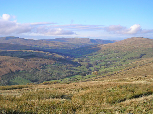
984:== {{int:filedesc}} == {{Information |description={{en|1=Dentdale Seen from the Driving Road which skirts Great Knoutberry.
Middleton Fell forms the central horizon. Rise Hill is on the right. Great Coum is the distant hill on the left.}} |date=2009-11
259:
209:
401:– You must give appropriate credit, provide a link to the license, and indicate if changes were made. You may do so in any reasonable manner, but not in any way that suggests the licensor endorses you or your use.
38:
121:
Dentdale Seen from the
Driving Road which skirts Great Knoutberry. Middleton Fell forms the central horizon. Rise Hill is on the right. Great Coum is the distant hill on the left.
862:
711:
465:
454:
78:
46:
797:
663:
627:
283:
233:
817:
318:
1009:
This file contains additional information, probably added from the digital camera or scanner used to create or digitize it.
408:
562:
903:
876:
825:
781:
752:
725:
611:
583:
570:
555:
840:
810:
683:
647:
528:
511:
305:
364:
1012:
If the file has been modified from its original state, some details may not fully reflect the modified file.
994:
The following pages on the
English Knowledge (XXG) use this file (pages on other projects are not listed):
966:
961:
37:
407:– If you remix, transform, or build upon the material, you must distribute your contributions under the
325:
on the
Geograph website for the photographer's contact details. The copyright on this image is owned by
977:
461:
Please remove redundant categories and try to put this image in the most specific category/categories.
361:
869:"}},"text\/plain":{"en":{"P7787":"270 degree"}}}}": -->
718:"}},"text\/plain":{"en":{"P7787":"270 degree"}}}}": -->
86:
178:
847:
832:
590:
162:
289:
239:
330:
73:
130:
273:
223:
141:
151:
998:
310:
322:
934:
Click on a date/time to view the file as it appeared at that time.
275:
225:
250:
200:
61:
451:
The categories of this image need checking. You can do so
260:
54° 16′ 30″ N, 2° 23′ 20″ W
210:
54° 16′ 46″ N, 2° 20′ 42″ W
495:
Add a one-line explanation of what this file represents
105:
85:
Commons is a freely licensed media file repository.
664:
Creative
Commons Attribution-ShareAlike 2.0 Generic
51:(640 × 480 pixels, file size: 96 KB, MIME type:
418:https://creativecommons.org/licenses/by-sa/2.0
66:
424:Creative Commons Attribution-Share Alike 2.0
342:
8:
866:
715:
384:– to copy, distribute and transmit the work
1014:
936:
491:
848:https://www.geograph.org.uk/photo/1579631
464:You can remove this template by clicking
591:https://www.geograph.org.uk/profile/1080
111:Dentdale - geograph.org.uk - 1579631.jpg
47:Dentdale_-_geograph.org.uk_-_1579631.jpg
1016:
996:
890:
874:
795:
779:
739:
723:
697:
681:
661:
645:
625:
609:
542:
526:
509:
506:
487:
480:
253:
203:
282:View this and other nearby images on:
232:View this and other nearby images on:
7:
329:and is licensed for reuse under the
925:
365:Attribution-Share Alike 2.0 Generic
353:
348:
333:Attribution-ShareAlike 2.0 license.
1007:
500:
494:
438:
339:
316:
115:
98:
44:
499:
726:coordinates of the point of view
485:
443:
395:Under the following conditions:
360:This file is licensed under the
352:
347:
341:
309:
288:
274:
266:
238:
224:
216:
65:
21:
482:
116:
41:No higher resolution available.
14:
798:file available on the internet
481:
317:This image was taken from the
26:
1:
877:coordinates of depicted place
191:John Illingworth /
172:John Illingworth /
31:
818:Geograph Britain and Ireland
556:object of statement has role
507:Items portrayed in this file
265:
215:
1038:
442:
409:same or compatible license
926:
892:54°16'29.6"N, 2°23'20.4"W
741:54°16'46.2"N, 2°20'42.0"W
16:
826:geograph.org.uk image ID
484:
375:
72:This is a file from the
983:
468:(or on the first line).
163:required by the license
147:
136:
129:
126:
108:
76:. Information from its
323:this photograph's page
294:54.274900; -2.389000
244:54.279500; -2.345000
79:description page there
962:20:09, 3 March 2011
390:– to adapt the work
571:author name string
1025:
1024:
987:
868:
717:
648:copyright license
493:
474:
473:
338:
337:
321:collection. See
299:
298:
249:
248:
198:
197:
166:
94:
93:
74:Wikimedia Commons
1029:
1015:
974:
914:
913:
908:
850:
845:
841:described at URL
835:
830:
820:
815:
763:
762:
757:
699:11 November 2009
612:copyright status
593:
588:
578:
577:John Illingworth
575:
565:
560:
447:
446:
440:
439:
431:
428:
425:
422:
419:
411:as the original.
373:
372:John Illingworth
362:Creative Commons
356:
355:
351:
350:
345:
344:
331:Creative Commons
327:John Illingworth
319:Geograph project
313:
306:
295:
292:
278:
277:
271:
270:
269:
263:
262:
251:
245:
242:
228:
227:
221:
220:
219:
213:
212:
201:
160:
152:John Illingworth
132:
131:11 November 2009
120:
112:
106:
90:
69:
68:
62:
56:
54:
1037:
1036:
1032:
1031:
1030:
1028:
1027:
1026:
1003:
995:
988:
980:
972:
928:
927:
924:
923:
922:
921:
920:
919:
918:
917:
916:
915:
911:
909:
906:
897:
896:
895:
893:
883:
882:
881:
879:
860:
859:
858:
857:
856:
855:
854:
853:
852:
851:
846:
843:
837:
836:
831:
828:
822:
821:
816:
813:
804:
803:
802:
800:
788:
787:
786:
784:
773:
772:
771:
770:
769:
768:
767:
766:
765:
764:
760:
758:
755:
746:
745:
744:
742:
732:
731:
730:
728:
709:
708:
707:
706:
705:
704:
703:
702:
700:
690:
689:
688:
686:
675:
674:
673:
672:
671:
670:
669:
668:
666:
654:
653:
652:
650:
639:
638:
637:
636:
635:
634:
633:
632:
630:
618:
617:
616:
614:
603:
602:
601:
600:
599:
598:
597:
596:
595:
594:
589:
586:
580:
579:
576:
573:
567:
566:
561:
558:
549:
548:
547:
545:
535:
534:
533:
531:
520:
519:
518:
517:
516:
514:
498:
497:
496:
479:
475:
444:
433:
432:
429:
426:
423:
420:
417:
416:
374:
371:
368:
357:
334:
304:
293:
267:
258:
257:
254:Object location
243:
217:
208:
207:
204:Camera location
199:
188:
181:
169:
142:geograph.org.uk
122:
110:
103:
96:
95:
84:
83:
82:is shown below.
58:
52:
50:
43:
42:
12:
11:
5:
1035:
1033:
1023:
1022:
1019:
1006:
1002:
1001:
993:
992:
991:
986:
985:
982:
978:
975:
969:
964:
959:
955:
954:
951:
948:
945:
942:
939:
932:
931:
902:
901:
900:
899:
898:
894:
891:
889:
888:
887:
886:
885:
884:
880:
875:
873:
872:
871:
870:
864:
839:
838:
824:
823:
809:
808:
807:
806:
805:
801:
796:
794:
793:
792:
791:
790:
789:
785:
782:source of file
780:
778:
777:
776:
775:
774:
751:
750:
749:
748:
747:
743:
740:
738:
737:
736:
735:
734:
733:
729:
724:
722:
721:
720:
719:
713:
701:
698:
696:
695:
694:
693:
692:
691:
687:
682:
680:
679:
678:
677:
676:
667:
662:
660:
659:
658:
657:
656:
655:
651:
646:
644:
643:
642:
641:
640:
631:
626:
624:
623:
622:
621:
620:
619:
615:
610:
608:
607:
606:
605:
604:
582:
581:
569:
568:
554:
553:
552:
551:
550:
546:
543:
541:
540:
539:
538:
537:
536:
532:
527:
525:
524:
523:
522:
521:
515:
510:
508:
505:
504:
503:
502:
501:
490:
489:
486:
483:
472:
471:
470:
469:
462:
448:
437:
415:
414:
413:
412:
402:
393:
392:
391:
385:
378:You are free:
369:
359:
358:
340:
336:
335:
314:
303:
300:
297:
296:
286:
280:
255:
247:
246:
236:
230:
205:
196:
195:
189:
186:
183:
182:
177:
170:
167:
155:
154:
149:
145:
144:
138:
134:
133:
128:
124:
123:
113:
104:
102:
99:
97:
92:
91:
70:
60:
59:
40:
36:
35:
34:
29:
24:
19:
13:
10:
9:
6:
4:
3:
2:
1034:
1020:
1017:
1013:
1010:
1004:
1000:
997:
989:
981:
976:
970:
968:
965:
963:
960:
957:
956:
952:
949:
946:
943:
940:
938:
937:
935:
929:
905:
878:
849:
842:
834:
827:
819:
812:
799:
783:
754:
727:
685:
665:
649:
629:
613:
592:
585:
572:
564:
557:
530:
513:
478:
477:
467:
463:
460:
459:
458:
456:
452:
449:
441:
436:
435:
421:CC BY-SA 2.0
410:
406:
403:
400:
397:
396:
394:
389:
386:
383:
380:
379:
377:
376:
370:Attribution:
366:
363:
346:
332:
328:
324:
320:
315:
312:
308:
307:
301:
291:
287:
285:
284:OpenStreetMap
281:
279:
261:
256:
252:
241:
237:
235:
234:OpenStreetMap
231:
229:
211:
206:
202:
194:
190:
185:
184:
180:
176: /
175:
171:
164:
159:
157:
156:
153:
150:
146:
143:
139:
135:
125:
119:
114:
107:
100:
88:
81:
80:
75:
71:
64:
63:
57:
48:
39:
33:
30:
28:
25:
23:
20:
18:
15:
1011:
1008:
933:
930:File history
563:photographer
476:
453:
450:
434:
404:
398:
387:
381:
326:
264:
214:
192:
179:CC BY-SA 2.0
173:
117:
87:You can help
77:
45:
22:File history
979:GeographBot
628:copyrighted
405:share alike
399:attribution
158:Attribution
109:Description
1018:_error
990:File usage
971:640 × 480
947:Dimensions
544:some value
53:image/jpeg
27:File usage
944:Thumbnail
941:Date/Time
684:inception
302:Licensing
187:InfoField
168:InfoField
118:English:
1005:Metadata
999:Dentdale
811:operator
488:Captions
388:to remix
382:to share
367:license.
193:Dentdale
174:Dentdale
32:Metadata
973:(96 KB)
958:current
953:Comment
904:heading
863:heading
833:1579631
753:heading
712:heading
529:creator
512:depicts
492:English
101:Summary
49:
912:degree
867:degree
761:degree
716:degree
272:
222:
148:Author
137:Source
140:From
950:User
910:270
759:270
466:here
455:here
430:true
427:true
127:Date
17:File
584:URL
907::
844::
829::
814::
756::
587::
574::
559::
1021:0
457:.
165:)
161:(
89:.
55:)
Text is available under the Creative Commons Attribution-ShareAlike License. Additional terms may apply.
_heading:270.00&language=en)
_heading:270.00&language=en)
