33:
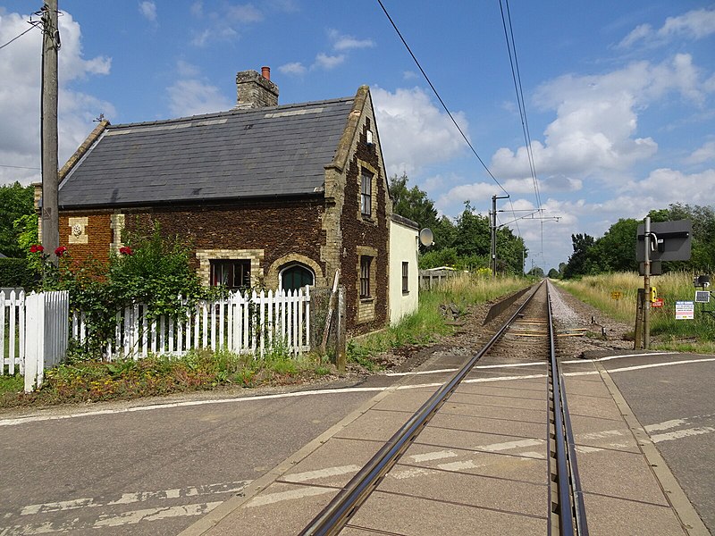
811:== {{int:filedesc}} == {{Information |Description={{en|1=<b>Denver railway station (site), Norfolk</b><br>Opened in 1847 by the Lynn & Ely Railway, later part of the Great Eastern Railway, on the line from Cambridge to King's Lynn, this station closed to passengers in 1870. However, it became the junction for a short branch line to Stoke Ferry in 1882 and reopened in 1885, but was only served by Stoke Ferry trains. Denver station and the Stoke Ferry branch line closed to passengers in 1930. D...
386:
319:
269:
311:
261:
333:
283:
354:
392:
397:
148:
Stoke Ferry trains. Denver station and the Stoke Ferry branch line closed to passengers in 1930. Denver station closed completely in 1964. View north towards
Downham Market and King's Lynn. The station had 2 parallel platforms (the railway line was singled in 1984), one of which was still extant when this image was taken. The junction for Stoke Ferry was behind the camera position.
89:
658:"}},"text\/plain":{"en":{"":"heading"}}},"{\"value\":{\"amount\":\"+0.0\",\"unit\":\"http:\\\/\\\/www.wikidata.org\\\/entity\\\/Q28390\"},\"type\":\"quantity\"}":{"text\/html":{"en":{"P7787":"0.0
594:"}},"text\/plain":{"en":{"":"heading"}}},"{\"value\":{\"amount\":\"+0\",\"unit\":\"http:\\\/\\\/www.wikidata.org\\\/entity\\\/Q28390\"},\"type\":\"quantity\"}":{"text\/html":{"en":{"P7787":"0
794:
654:
252:
55:
51:
47:
43:
37:
444:– You must give appropriate credit, provide a link to the license, and indicate if changes were made. You may do so in any reasonable manner, but not in any way that suggests the licensor endorses you or your use.
68:
100:
655:
591:
793:
788:
59:
32:
189:
825:
577:
541:
326:
276:
361:
451:
696:
669:
632:
605:
525:
725:
561:
508:
348:
407:
821:
The following pages on the
English Knowledge (XXG) use this file (pages on other projects are not listed):
450:– If you remix, transform, or build upon the material, you must distribute your contributions under the
368:
on the
Geograph website for the photographer's contact details. The copyright on this image is owned by
404:
662:"}},"text\/plain":{"en":{"P7787":"0.0 degree"}}}}": -->
598:"}},"text\/plain":{"en":{"P7787":"0 degree"}}}}": -->
108:
804:
205:
332:
282:
373:
95:
221:
266:
157:
316:
178:
168:
353:
365:
761:
Click on a date/time to view the file as it appeared at that time.
318:
268:
293:
243:
83:
133:
Denver railway station (site), Norfolk (geograph 6927381).jpg
303:
52° 34′ 55.2″ N, 0° 21′ 22″ E
253:
52° 34′ 53.6″ N, 0° 21′ 22″ E
492:
Add a one-line explanation of what this file represents
73:(1,600 × 1,200 pixels, file size: 527 KB, MIME type:
196:
Creative
Commons Attribution Share-alike license 2.0
127:
107:
Commons is a freely licensed media file repository.
578:
Creative
Commons Attribution-ShareAlike 2.0 Generic
461:https://creativecommons.org/licenses/by-sa/2.0
88:
467:Creative Commons Attribution-Share Alike 2.0
385:
8:
659:
595:
427:– to copy, distribute and transmit the work
763:
488:
823:
739:
723:
683:
667:
619:
603:
575:
559:
539:
523:
506:
503:
484:
477:
296:
246:
325:View this and other nearby images on:
275:View this and other nearby images on:
236:Denver Railway station (site), Norfolk
217:Denver Railway station (site), Norfolk
144:Denver railway station (site), Norfolk
7:
372:and is licensed for reuse under the
752:
408:Attribution-Share Alike 2.0 Generic
396:
391:
376:Attribution-ShareAlike 2.0 license.
497:
491:
382:
359:
137:
120:
66:
496:
826:Denver railway station (England)
670:coordinates of the point of view
482:
438:Under the following conditions:
403:This file is licensed under the
395:
390:
384:
352:
331:
317:
309:
281:
267:
259:
87:
21:
479:
138:
14:
478:
360:This image was taken from the
26:
1:
685:52°34'53.580"N, 0°21'21.787"E
606:coordinates of depicted place
504:Items portrayed in this file
621:52°34'55.20"N, 0°21'22.39"E
234:Nigel Thompson /
215:Nigel Thompson /
842:
452:same or compatible license
308:
258:
753:
16:
481:
418:
94:This is a file from the
810:
789:17:22, 14 November 2021
206:required by the license
184:
174:
163:
156:
153:
130:
98:. Information from its
366:this photograph's page
337:52.582000; 0.356220
287:52.581550; 0.356052
101:description page there
36:Size of this preview:
60:1,600 × 1,200 pixels
433:– to adapt the work
42:Other resolutions:
56:1,280 × 960 pixels
52:1,024 × 768 pixels
814:
661:
597:
562:copyright license
490:
381:
380:
364:collection. See
342:
341:
292:
291:
241:
240:
209:
193:
190:Reusing this file
116:
115:
96:Wikimedia Commons
833:
801:
707:
706:
701:
643:
642:
637:
526:copyright status
474:
471:
468:
465:
462:
454:as the original.
416:
405:Creative Commons
399:
398:
394:
393:
388:
387:
374:Creative Commons
362:Geograph project
356:
349:
338:
335:
321:
320:
314:
313:
312:
306:
305:
294:
288:
285:
271:
270:
264:
263:
262:
256:
255:
244:
203:
187:
159:
142:
134:
128:
112:
91:
90:
84:
78:
76:
63:
48:640 × 480 pixels
44:320 × 240 pixels
38:800 × 600 pixels
841:
840:
836:
835:
834:
832:
831:
830:
822:
815:
807:
799:
755:
754:
751:
750:
749:
748:
747:
746:
745:
744:
742:
732:
731:
730:
728:
717:
716:
715:
714:
713:
712:
711:
710:
709:
708:
704:
702:
699:
690:
689:
688:
686:
676:
675:
674:
672:
653:
652:
651:
650:
649:
648:
647:
646:
645:
644:
640:
638:
635:
626:
625:
624:
622:
612:
611:
610:
608:
589:
588:
587:
586:
585:
584:
583:
582:
580:
568:
567:
566:
564:
553:
552:
551:
550:
549:
548:
547:
546:
544:
532:
531:
530:
528:
517:
516:
515:
514:
513:
511:
495:
494:
493:
476:
475:
472:
469:
466:
463:
460:
459:
417:
414:
411:
400:
377:
347:
336:
310:
301:
300:
297:Object location
286:
260:
251:
250:
247:Camera location
242:
231:
224:
212:
169:geograph.org.uk
149:
132:
125:
118:
117:
106:
105:
104:is shown below.
80:
74:
72:
65:
64:
41:
12:
11:
5:
839:
837:
829:
828:
820:
819:
818:
813:
812:
809:
805:
802:
798:1,600 × 1,200
796:
791:
786:
782:
781:
778:
775:
772:
769:
766:
759:
758:
743:
740:
738:
737:
736:
735:
734:
733:
729:
724:
722:
721:
720:
719:
718:
695:
694:
693:
692:
691:
687:
684:
682:
681:
680:
679:
678:
677:
673:
668:
666:
665:
664:
663:
657:
631:
630:
629:
628:
627:
623:
620:
618:
617:
616:
615:
614:
613:
609:
604:
602:
601:
600:
599:
593:
581:
576:
574:
573:
572:
571:
570:
569:
565:
560:
558:
557:
556:
555:
554:
545:
540:
538:
537:
536:
535:
534:
533:
529:
524:
522:
521:
520:
519:
518:
512:
507:
505:
502:
501:
500:
499:
498:
487:
486:
483:
480:
458:
457:
456:
455:
445:
436:
435:
434:
428:
421:You are free:
415:Nigel Thompson
412:
402:
401:
383:
379:
378:
370:Nigel Thompson
357:
346:
343:
340:
339:
329:
323:
298:
290:
289:
279:
273:
248:
239:
238:
232:
229:
226:
225:
220:
213:
210:
198:
197:
194:
182:
181:
179:Nigel Thompson
176:
172:
171:
165:
161:
160:
155:
151:
150:
135:
126:
124:
121:
119:
114:
113:
92:
82:
81:
35:
31:
30:
29:
24:
19:
13:
10:
9:
6:
4:
3:
2:
838:
827:
824:
816:
808:
803:
797:
795:
792:
790:
787:
784:
783:
779:
776:
773:
770:
767:
765:
764:
762:
756:
741:5 August 2021
727:
698:
671:
634:
607:
579:
563:
543:
527:
510:
464:CC BY-SA 2.0
453:
449:
446:
443:
440:
439:
437:
432:
429:
426:
423:
422:
420:
419:
413:Attribution:
409:
406:
389:
375:
371:
367:
363:
358:
355:
351:
350:
344:
334:
330:
328:
327:OpenStreetMap
324:
322:
304:
299:
295:
284:
280:
278:
277:OpenStreetMap
274:
272:
254:
249:
245:
237:
233:
228:
227:
223:
219: /
218:
214:
207:
202:
200:
199:
195:
191:
186:
183:
180:
177:
173:
170:
166:
162:
158:5 August 2021
152:
146:
145:
141:
136:
129:
122:
110:
103:
102:
97:
93:
86:
85:
79:
70:
69:Original file
61:
57:
53:
49:
45:
39:
34:
28:
25:
23:
20:
18:
15:
760:
757:File history
447:
441:
430:
424:
369:
307:
257:
235:
222:CC BY-SA 2.0
216:
143:
139:
109:You can help
99:
67:
22:File history
806:Lamberhurst
542:copyrighted
448:share alike
442:attribution
201:Attribution
131:Description
817:File usage
774:Dimensions
185:Permission
75:image/jpeg
27:File usage
771:Thumbnail
768:Date/Time
726:inception
345:Licensing
230:InfoField
211:InfoField
140:English:
800:(527 KB)
485:Captions
431:to remix
425:to share
410:license.
785:current
780:Comment
697:heading
656:heading
633:heading
592:heading
509:depicts
489:English
123:Summary
71:
705:degree
660:degree
641:degree
596:degree
315:
265:
175:Author
164:Source
167:From
777:User
703:0.0
473:true
470:true
154:Date
17:File
700::
639:0
636::
58:|
54:|
50:|
46:|
40:.
208:)
204:(
192:)
188:(
111:.
77:)
62:.
Text is available under the Creative Commons Attribution-ShareAlike License. Additional terms may apply.

,_Norfolk_(geograph_6927381).jpg)
,_Norfolk_(geograph_6927381).jpg¶ms=052.581550_N_0000.356052_E_globe:Earth_type:camera_source:geograph-osgb36(TF59730080)_heading:0.00&language=en)
,_Norfolk_(geograph_6927381).jpg¶ms=052.582000_N_0000.356220_E_globe:Earth_class:object_type:object_source:geograph-osgb36(TF59740085)_heading:0.00&language=en)
