43:
346:
279:
271:
293:
314:
352:
357:
99:
758:"}},"text\/plain":{"en":{"":"heading"}}},"{\"value\":{\"amount\":\"+180\",\"unit\":\"http:\\\/\\\/www.wikidata.org\\\/entity\\\/Q28390\"},\"type\":\"quantity\"}":{"text\/html":{"en":{"P7787":"180
754:
877:== {{int:filedesc}} == {{Information |Description={{en|1='''Site of Dumgoyne station, 1997.'''<br/> View southward at the Beech Tree Inn on the A81 in the Blane Water valley, towards Lenzie Junction and Glasgow: ex-NBR Glasgow (Queen St.) - Aberfoyle l...
157:
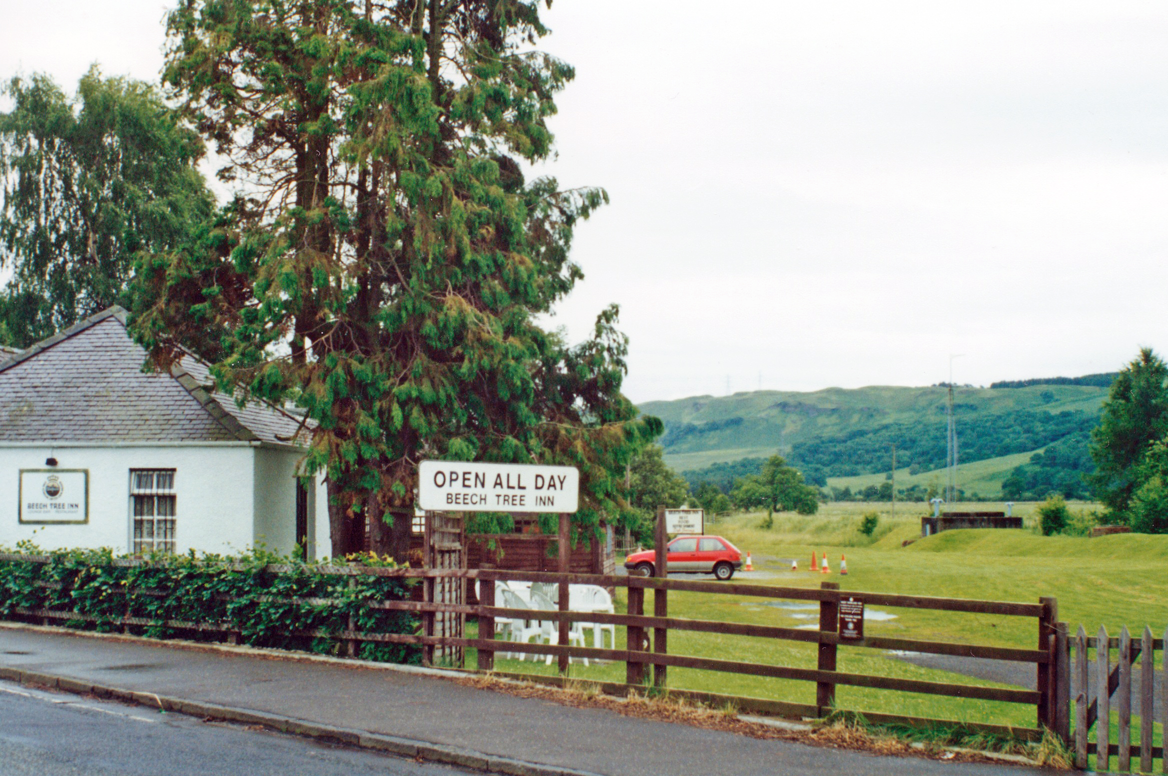
View southward at the Beech Tree Inn on the A81 in the Blane Water valley, towards Lenzie
Junction and Glasgow: ex-NBR Glasgow (Queen St.) - Aberfoyle line. The station and line were closed to passengers from 1/10/51, to goods from 5/10/59. The Beech Tree Inn incorporated former railway
262:
404:– You must give appropriate credit, provide a link to the license, and indicate if changes were made. You may do so in any reasonable manner, but not in any way that suggests the licensor endorses you or your use.
65:
61:
57:
53:
47:
110:
78:
755:
1008:
199:
656:
620:
584:
286:
859:
854:
676:
69:
42:
1023:
321:
922:
This file contains additional information, probably added from the digital camera or scanner used to create or digitize it.
411:
519:
796:
769:
684:
640:
568:
540:
527:
512:
727:
699:
669:
604:
485:
468:
308:
891:
367:
925:
If the file has been modified from its original state, some details may not fully reflect the modified file.
410:– If you remix, transform, or build upon the material, you must distribute your contributions under the
328:
on the
Geograph website for the photographer's contact details. The copyright on this image is owned by
364:
762:"}},"text\/plain":{"en":{"P7787":"180 degree"}}}}": -->
118:
231:
706:
691:
547:
215:
292:
333:
105:
1034:
870:
276:
167:
188:
178:
313:
325:
827:
Click on a date/time to view the file as it appeared at that time.
278:
263:
56° 01′ 12.82″ N, 4° 22′ 16.93″ W
253:
93:
143:
Dumgoyne station site geograph-3869511-by-Ben-Brooksbank.jpg
452:
Add a one-line explanation of what this file represents
909:
83:(2,337 × 1,554 pixels, file size: 2.73 MB, MIME type:
206:
Creative
Commons Attribution Share-alike license 2.0
137:
117:
Commons is a freely licensed media file repository.
621:
Creative
Commons Attribution-ShareAlike 2.0 Generic
421:https://creativecommons.org/licenses/by-sa/2.0
98:
427:Creative Commons Attribution-Share Alike 2.0
345:
8:
759:
387:– to copy, distribute and transmit the work
927:
829:
448:
902:The following other wikis use this file:
707:https://www.geograph.org.uk/photo/3869511
548:https://www.geograph.org.uk/profile/44502
1066:
1058:
1050:
1042:
1032:
1021:
1013:
1003:
995:
987:
979:
971:
963:
945:
937:
929:
889:
783:
767:
741:
725:
654:
638:
618:
602:
582:
566:
499:
483:
466:
463:
444:
437:
256:
285:View this and other nearby images on:
1009:Adobe Photoshop Elements 12.0 Windows
7:
332:and is licensed for reuse under the
887:The following page uses this file:
818:
368:Attribution-Share Alike 2.0 Generic
356:
351:
336:Attribution-ShareAlike 2.0 license.
920:
457:
451:
342:
319:
147:
130:
76:
456:
1047:33DCA20FBF0289E6F4F7EFDA409783C2
770:coordinates of the point of view
442:
398:Under the following conditions:
363:This file is licensed under the
355:
350:
344:
312:
291:
277:
269:
97:
31:
21:
1060:Date metadata was last modified
439:
154:Site of Dumgoyne station, 1997.
148:
14:
1044:Unique ID of original document
657:file available on the internet
438:
320:This image was taken from the
246:Site of Dumgoyne station, 1997
227:Site of Dumgoyne station, 1997
26:
1:
36:
785:56°1'12.821"N, 4°22'16.932"W
677:Geograph Britain and Ireland
513:object of statement has role
464:Items portrayed in this file
268:
1052:Date and time of digitizing
244:Ben Brooksbank /
225:Ben Brooksbank /
1088:
906:Usage on www.wikidata.org
412:same or compatible license
1015:File change date and time
819:
16:
892:Dumgoyne railway station
685:geograph.org.uk image ID
441:
378:
104:This is a file from the
876:
216:required by the license
194:
184:
173:
166:
163:
140:
108:. Information from its
326:this photograph's page
297:56.020228; -4.371370
111:description page there
46:Size of this preview:
989:Horizontal resolution
981:Number of components
855:10:24, 23 March 2014
70:2,337 × 1,554 pixels
1063:23:09, 2 March 2014
1055:23:06, 2 March 2014
1018:23:09, 2 March 2014
997:Vertical resolution
393:– to adapt the work
52:Other resolutions:
947:Bits per component
528:author name string
66:1,280 × 851 pixels
62:1,024 × 681 pixels
1075:
1074:
965:Pixel composition
898:Global file usage
880:
761:
605:copyright license
450:
341:
340:
324:collection. See
302:
301:
251:
250:
219:
203:
200:Reusing this file
126:
125:
106:Wikimedia Commons
32:Global file usage
1079:
928:
867:
807:
806:
801:
709:
704:
700:described at URL
694:
689:
679:
674:
569:copyright status
550:
545:
535:
532:
522:
517:
434:
431:
428:
425:
422:
414:as the original.
376:
365:Creative Commons
359:
358:
354:
353:
348:
347:
334:Creative Commons
322:Geograph project
316:
309:
298:
295:
281:
280:
274:
273:
272:
266:
265:
254:
213:
197:
169:
152:
144:
138:
122:
101:
100:
94:
88:
86:
73:
58:640 × 426 pixels
54:320 × 213 pixels
48:800 × 532 pixels
1087:
1086:
1082:
1081:
1080:
1078:
1077:
1076:
916:
896:
881:
873:
865:
821:
820:
817:
816:
815:
814:
813:
812:
811:
810:
809:
808:
804:
802:
799:
790:
789:
788:
786:
776:
775:
774:
772:
753:
752:
751:
750:
749:
748:
747:
746:
744:
734:
733:
732:
730:
719:
718:
717:
716:
715:
714:
713:
712:
711:
710:
705:
702:
696:
695:
690:
687:
681:
680:
675:
672:
663:
662:
661:
659:
647:
646:
645:
643:
632:
631:
630:
629:
628:
627:
626:
625:
623:
611:
610:
609:
607:
596:
595:
594:
593:
592:
591:
590:
589:
587:
575:
574:
573:
571:
560:
559:
558:
557:
556:
555:
554:
553:
552:
551:
546:
543:
537:
536:
533:
530:
524:
523:
518:
515:
506:
505:
504:
502:
492:
491:
490:
488:
477:
476:
475:
474:
473:
471:
455:
454:
453:
436:
435:
432:
429:
426:
423:
420:
419:
377:
374:
371:
360:
337:
307:
296:
270:
261:
260:
257:Camera location
252:
241:
234:
222:
179:geograph.org.uk
159:
142:
135:
128:
127:
116:
115:
114:is shown below.
90:
84:
82:
75:
74:
51:
12:
11:
5:
1085:
1083:
1073:
1072:
1069:
1065:
1064:
1061:
1057:
1056:
1053:
1049:
1048:
1045:
1041:
1040:
1037:
1031:
1030:
1027:
1020:
1019:
1016:
1012:
1011:
1006:
1002:
1001:
998:
994:
993:
990:
986:
985:
982:
978:
977:
974:
970:
969:
966:
962:
961:
960:
959:
956:
953:
948:
944:
943:
940:
936:
935:
932:
919:
915:
914:
913:
912:
900:
899:
895:
894:
885:
884:
879:
878:
875:
871:
868:
864:2,337 × 1,554
862:
857:
852:
848:
847:
844:
841:
838:
835:
832:
825:
824:
795:
794:
793:
792:
791:
787:
784:
782:
781:
780:
779:
778:
777:
773:
768:
766:
765:
764:
763:
757:
745:
742:
740:
739:
738:
737:
736:
735:
731:
726:
724:
723:
722:
721:
720:
698:
697:
683:
682:
668:
667:
666:
665:
664:
660:
655:
653:
652:
651:
650:
649:
648:
644:
641:source of file
639:
637:
636:
635:
634:
633:
624:
619:
617:
616:
615:
614:
613:
612:
608:
603:
601:
600:
599:
598:
597:
588:
583:
581:
580:
579:
578:
577:
576:
572:
567:
565:
564:
563:
562:
561:
539:
538:
534:Ben Brooksbank
526:
525:
511:
510:
509:
508:
507:
503:
500:
498:
497:
496:
495:
494:
493:
489:
484:
482:
481:
480:
479:
478:
472:
467:
465:
462:
461:
460:
459:
458:
447:
446:
443:
440:
418:
417:
416:
415:
405:
396:
395:
394:
388:
381:You are free:
375:Ben Brooksbank
372:
362:
361:
343:
339:
338:
330:Ben Brooksbank
317:
306:
303:
300:
299:
289:
283:
258:
249:
248:
242:
239:
236:
235:
230:
223:
220:
208:
207:
204:
192:
191:
189:Ben Brooksbank
186:
182:
181:
175:
171:
170:
165:
161:
160:
145:
136:
134:
131:
129:
124:
123:
102:
92:
91:
45:
41:
40:
39:
34:
29:
24:
19:
13:
10:
9:
6:
4:
3:
2:
1084:
1070:
1067:
1062:
1059:
1054:
1051:
1046:
1043:
1038:
1036:
1033:
1028:
1025:
1022:
1017:
1014:
1010:
1007:
1005:Software used
1004:
999:
996:
991:
988:
983:
980:
975:
972:
967:
964:
957:
954:
951:
950:
949:
946:
941:
938:
933:
930:
926:
923:
917:
911:
908:
907:
905:
904:
903:
897:
893:
890:
888:
882:
874:
869:
863:
861:
858:
856:
853:
850:
849:
845:
842:
839:
836:
833:
831:
830:
828:
822:
798:
771:
729:
708:
701:
693:
686:
678:
671:
658:
642:
622:
606:
586:
570:
549:
542:
529:
521:
514:
487:
470:
424:CC BY-SA 2.0
413:
409:
406:
403:
400:
399:
397:
392:
389:
386:
383:
382:
380:
379:
373:Attribution:
369:
366:
349:
335:
331:
327:
323:
318:
315:
311:
310:
304:
294:
290:
288:
287:OpenStreetMap
284:
282:
264:
259:
255:
247:
243:
238:
237:
233:
229: /
228:
224:
217:
212:
210:
209:
205:
201:
196:
193:
190:
187:
183:
180:
176:
172:
162:
156:
155:
151:
146:
139:
132:
120:
113:
112:
107:
103:
96:
95:
89:
80:
79:Original file
71:
67:
63:
59:
55:
49:
44:
38:
35:
33:
30:
28:
25:
23:
20:
18:
15:
924:
921:
901:
886:
826:
823:File history
520:photographer
407:
401:
390:
384:
329:
267:
245:
232:CC BY-SA 2.0
226:
153:
149:
119:You can help
109:
77:
22:File history
1068:IIM version
1035:Color space
973:Orientation
743:1 July 1997
585:copyrighted
408:share alike
402:attribution
211:Attribution
168:1 July 1997
141:Description
883:File usage
840:Dimensions
501:some value
195:Permission
85:image/jpeg
27:File usage
910:Q79802706
866:(2.73 MB)
837:Thumbnail
834:Date/Time
728:inception
305:Licensing
240:InfoField
221:InfoField
158:cottages.
150:English:
942:1,554 px
934:2,337 px
918:Metadata
670:operator
445:Captions
391:to remix
385:to share
370:license.
37:Metadata
1026:version
1000:400 dpi
992:400 dpi
851:current
846:Comment
797:heading
756:heading
692:3869511
486:creator
469:depicts
449:English
133:Summary
81:
1071:39,418
976:Normal
939:Height
872:Chevin
805:degree
760:degree
275:
185:Author
174:Source
931:Width
177:From
1039:sRGB
1029:2.21
1024:Exif
843:User
803:180
433:true
430:true
164:Date
17:File
968:RGB
541:URL
800::
703::
688::
673::
544::
531::
516::
68:|
64:|
60:|
56:|
50:.
984:3
958:8
955:8
952:8
218:)
214:(
202:)
198:(
121:.
87:)
72:.
Text is available under the Creative Commons Attribution-ShareAlike License. Additional terms may apply.
