382:
315:
265:
38:
307:
257:
329:
279:
350:
388:
393:
90:
858:"}},"text\/plain":{"en":{"":"heading"}}},"{\"value\":{\"amount\":\"+270\",\"unit\":\"http:\\\/\\\/www.wikidata.org\\\/entity\\\/Q28390\"},\"type\":\"quantity\"}":{"text\/html":{"en":{"P7787":"270
794:"}},"text\/plain":{"en":{"":"heading"}}},"{\"value\":{\"amount\":\"+270\",\"unit\":\"http:\\\/\\\/www.wikidata.org\\\/entity\\\/Q28390\"},\"type\":\"quantity\"}":{"text\/html":{"en":{"P7787":"270
994:
790:
248:
440:– You must give appropriate credit, provide a link to the license, and indicate if changes were made. You may do so in any reasonable manner, but not in any way that suggests the licensor endorses you or your use.
56:
52:
48:
42:
69:
101:
855:
791:
185:
692:
656:
620:
322:
272:
993:
988:
60:
37:
712:
357:
447:
555:
925:
896:
869:
832:
805:
720:
676:
604:
576:
563:
548:
763:
735:
705:
640:
521:
504:
344:
403:
1025:
1021:
The following pages on the
English Knowledge (XXG) use this file (pages on other projects are not listed):
446:– If you remix, transform, or build upon the material, you must distribute your contributions under the
364:
on the
Geograph website for the photographer's contact details. The copyright on this image is owned by
400:
862:"}},"text\/plain":{"en":{"P7787":"270 degree"}}}}": -->
798:"}},"text\/plain":{"en":{"P7787":"270 degree"}}}}": -->
109:
217:
742:
727:
583:
201:
328:
278:
369:
96:
262:
153:
312:
1004:
164:
174:
349:
361:
961:
Click on a date/time to view the file as it appeared at that time.
314:
264:
249:
51° 08′ 24.31″ N, 3° 00′ 21.98″ W
289:
239:
84:
299:
51° 08′ 24.5″ N, 3° 00′ 23″ W
488:
Add a one-line explanation of what this file represents
134:
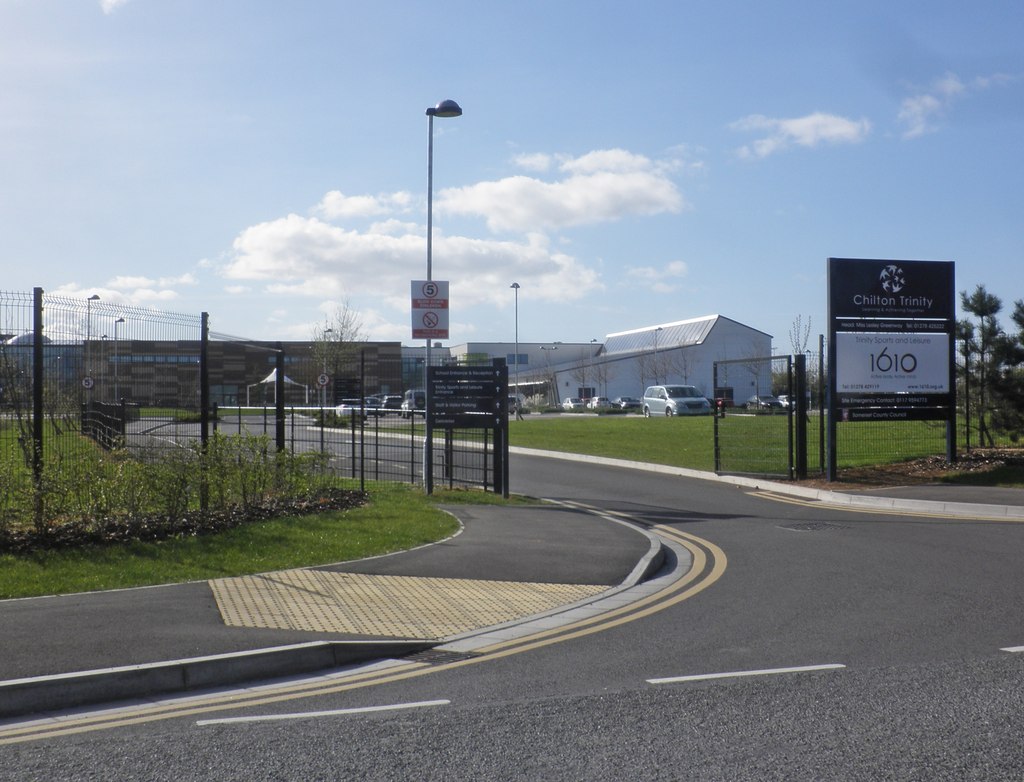
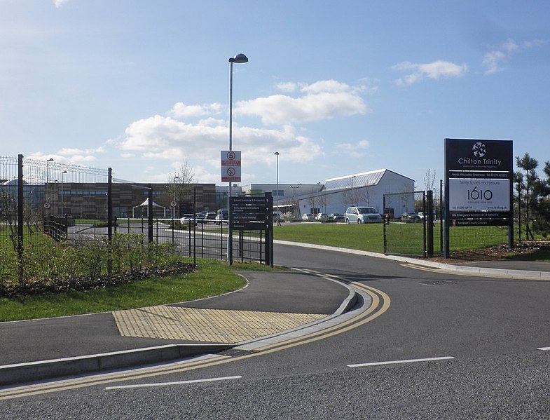
Entrance, Chilton
Trinity School (geograph 4425359).jpg
1043:
192:
Creative
Commons Attribution Share-alike license 2.0
128:
108:
Commons is a freely licensed media file repository.
657:
Creative
Commons Attribution-ShareAlike 2.0 Generic
74:(1,024 × 782 pixels, file size: 148 KB, MIME type:
457:https://creativecommons.org/licenses/by-sa/2.0
89:
463:Creative Commons Attribution-Share Alike 2.0
381:
8:
859:
795:
423:– to copy, distribute and transmit the work
963:
484:
1036:The following other wikis use this file:
743:https://www.geograph.org.uk/photo/4425359
584:https://www.geograph.org.uk/profile/8800
1023:
939:
923:
883:
867:
819:
803:
777:
761:
690:
674:
654:
638:
618:
602:
535:
519:
502:
499:
480:
473:
292:
242:
1011:Transferred from geograph.co.uk using
321:View this and other nearby images on:
271:View this and other nearby images on:
7:
368:and is licensed for reuse under the
952:
404:Attribution-Share Alike 2.0 Generic
392:
387:
372:Attribution-ShareAlike 2.0 license.
493:
487:
378:
355:
138:
121:
67:
492:
806:coordinates of the point of view
478:
434:Under the following conditions:
399:This file is licensed under the
391:
386:
380:
348:
327:
313:
305:
277:
263:
255:
232:Entrance, Chilton Trinity School
213:Entrance, Chilton Trinity School
144:Entrance, Chilton Trinity School
88:
31:
21:
475:
139:
14:
693:file available on the internet
474:
356:This image was taken from the
26:
1:
870:coordinates of depicted place
713:Geograph Britain and Ireland
549:object of statement has role
500:Items portrayed in this file
304:
254:
821:51°8'24.306"N, 3°0'21.978"W
230:Roger Cornfoot /
211:Roger Cornfoot /
1062:
1040:Usage on www.wikidata.org
448:same or compatible license
953:
885:51°8'24.47"N, 3°0'23.40"W
16:
721:geograph.org.uk image ID
477:
414:
95:This is a file from the
1010:
989:20:39, 9 September 2016
202:required by the license
180:
170:
159:
152:
149:
131:
99:. Information from its
1026:Chilton Trinity School
362:this photograph's page
333:51.140130; -3.006500
283:51.140085; -3.006105
102:description page there
41:Size of this preview:
429:– to adapt the work
47:Other resolutions:
564:author name string
61:1,024 × 782 pixels
57:1,006 × 768 pixels
1032:Global file usage
1014:
861:
797:
641:copyright license
486:
377:
376:
360:collection. See
338:
337:
288:
287:
237:
236:
205:
189:
186:Reusing this file
117:
116:
97:Wikimedia Commons
32:Global file usage
1053:
1001:
907:
906:
901:
843:
842:
837:
745:
740:
736:described at URL
730:
725:
715:
710:
605:copyright status
586:
581:
571:
568:
558:
553:
470:
467:
464:
461:
458:
450:as the original.
412:
401:Creative Commons
395:
394:
390:
389:
384:
383:
370:Creative Commons
358:Geograph project
352:
345:
334:
331:
317:
316:
310:
309:
308:
302:
301:
290:
284:
281:
267:
266:
260:
259:
258:
252:
251:
240:
199:
183:
155:
143:
135:
129:
113:
92:
91:
85:
79:
77:
64:
53:629 × 480 pixels
49:314 × 240 pixels
43:785 × 599 pixels
1061:
1060:
1056:
1055:
1054:
1052:
1051:
1050:
1030:
1022:
1015:
1007:
999:
955:
954:
951:
950:
949:
948:
947:
946:
945:
944:
942:
932:
931:
930:
928:
917:
916:
915:
914:
913:
912:
911:
910:
909:
908:
904:
902:
899:
890:
889:
888:
886:
876:
875:
874:
872:
853:
852:
851:
850:
849:
848:
847:
846:
845:
844:
840:
838:
835:
826:
825:
824:
822:
812:
811:
810:
808:
789:
788:
787:
786:
785:
784:
783:
782:
780:
770:
769:
768:
766:
755:
754:
753:
752:
751:
750:
749:
748:
747:
746:
741:
738:
732:
731:
726:
723:
717:
716:
711:
708:
699:
698:
697:
695:
683:
682:
681:
679:
668:
667:
666:
665:
664:
663:
662:
661:
659:
647:
646:
645:
643:
632:
631:
630:
629:
628:
627:
626:
625:
623:
611:
610:
609:
607:
596:
595:
594:
593:
592:
591:
590:
589:
588:
587:
582:
579:
573:
572:
569:
566:
560:
559:
554:
551:
542:
541:
540:
538:
528:
527:
526:
524:
513:
512:
511:
510:
509:
507:
491:
490:
489:
472:
471:
468:
465:
462:
459:
456:
455:
413:
410:
407:
396:
373:
343:
332:
306:
297:
296:
293:Object location
282:
256:
247:
246:
243:Camera location
238:
227:
220:
208:
165:geograph.org.uk
145:
133:
126:
119:
118:
107:
106:
105:is shown below.
81:
75:
73:
66:
65:
46:
12:
11:
5:
1059:
1057:
1049:
1048:
1047:
1046:
1034:
1033:
1029:
1028:
1020:
1019:
1018:
1013:
1012:
1009:
1005:
1002:
996:
991:
986:
982:
981:
978:
975:
972:
969:
966:
959:
958:
943:
940:
938:
937:
936:
935:
934:
933:
929:
924:
922:
921:
920:
919:
918:
895:
894:
893:
892:
891:
887:
884:
882:
881:
880:
879:
878:
877:
873:
868:
866:
865:
864:
863:
857:
831:
830:
829:
828:
827:
823:
820:
818:
817:
816:
815:
814:
813:
809:
804:
802:
801:
800:
799:
793:
781:
778:
776:
775:
774:
773:
772:
771:
767:
762:
760:
759:
758:
757:
756:
734:
733:
719:
718:
704:
703:
702:
701:
700:
696:
691:
689:
688:
687:
686:
685:
684:
680:
677:source of file
675:
673:
672:
671:
670:
669:
660:
655:
653:
652:
651:
650:
649:
648:
644:
639:
637:
636:
635:
634:
633:
624:
619:
617:
616:
615:
614:
613:
612:
608:
603:
601:
600:
599:
598:
597:
575:
574:
570:Roger Cornfoot
562:
561:
547:
546:
545:
544:
543:
539:
536:
534:
533:
532:
531:
530:
529:
525:
520:
518:
517:
516:
515:
514:
508:
503:
501:
498:
497:
496:
495:
494:
483:
482:
479:
476:
454:
453:
452:
451:
441:
432:
431:
430:
424:
417:You are free:
411:Roger Cornfoot
408:
398:
397:
379:
375:
374:
366:Roger Cornfoot
353:
342:
339:
336:
335:
325:
319:
294:
286:
285:
275:
269:
244:
235:
234:
228:
225:
222:
221:
216:
209:
206:
194:
193:
190:
178:
177:
175:Roger Cornfoot
172:
168:
167:
161:
157:
156:
151:
147:
146:
136:
127:
125:
122:
120:
115:
114:
93:
83:
82:
40:
36:
35:
34:
29:
24:
19:
13:
10:
9:
6:
4:
3:
2:
1058:
1045:
1042:
1041:
1039:
1038:
1037:
1031:
1027:
1024:
1016:
1008:
1003:
997:
995:
992:
990:
987:
984:
983:
979:
976:
973:
970:
967:
965:
964:
962:
956:
927:
898:
871:
834:
807:
779:11 April 2015
765:
744:
737:
729:
722:
714:
707:
694:
678:
658:
642:
622:
606:
585:
578:
565:
557:
550:
523:
506:
460:CC BY-SA 2.0
449:
445:
442:
439:
436:
435:
433:
428:
425:
422:
419:
418:
416:
415:
409:Attribution:
405:
402:
385:
371:
367:
363:
359:
354:
351:
347:
346:
340:
330:
326:
324:
323:OpenStreetMap
320:
318:
300:
295:
291:
280:
276:
274:
273:OpenStreetMap
270:
268:
250:
245:
241:
233:
229:
224:
223:
219:
215: /
214:
210:
203:
198:
196:
195:
191:
187:
182:
179:
176:
173:
169:
166:
162:
158:
154:11 April 2015
148:
142:
137:
130:
123:
111:
104:
103:
98:
94:
87:
86:
80:
71:
70:Original file
62:
58:
54:
50:
44:
39:
33:
30:
28:
25:
23:
20:
18:
15:
1035:
998:1,024 × 782
960:
957:File history
556:photographer
443:
437:
426:
420:
365:
303:
253:
231:
218:CC BY-SA 2.0
212:
140:
110:You can help
100:
68:
22:File history
621:copyrighted
444:share alike
438:attribution
197:Attribution
132:Description
1017:File usage
974:Dimensions
941:image/jpeg
926:media type
537:some value
181:Permission
76:image/jpeg
27:File usage
971:Thumbnail
968:Date/Time
764:inception
341:Licensing
226:InfoField
207:InfoField
141:English:
1044:Q5099243
1000:(148 KB)
706:operator
481:Captions
427:to remix
421:to share
406:license.
985:current
980:Comment
897:heading
856:heading
833:heading
792:heading
728:4425359
522:creator
505:depicts
485:English
124:Summary
72:
905:degree
860:degree
841:degree
796:degree
311:
261:
171:Author
160:Source
163:From
1006:Rodw
977:User
903:270
839:270
469:true
466:true
150:Date
17:File
577:URL
900::
836::
739::
724::
709::
580::
567::
552::
59:|
55:|
51:|
45:.
204:)
200:(
188:)
184:(
112:.
78:)
63:.
Text is available under the Creative Commons Attribution-ShareAlike License. Additional terms may apply.
.jpg)
.jpg¶ms=051.140085_N_-003.006105_E_globe:Earth_type:camera_heading:270.00_source:geograph&language=en)
.jpg¶ms=051.140130_N_-003.006500_E_globe:Earth_class:object_type:object_source:geograph-osgb36(ST29683835)_region:GB-GBN_heading:270.00&language=en)
