110:
275:
155:
371:
169:
281:
286:
72:
837:
854:{{Location|39|10|16|N|82|20|13|W}} {{Information |Description={{en|One end of the {{w|Eakin Mill Covered Bridge}}, which carries Mound Hill Road over Raccoon Creek north of {{w|Arbaugh, Ohio|Arbaugh}} in {{w|Vinton Township, Vinton County, Ohio|Vinton Tow
936:
883:
327:– You must give appropriate credit, provide a link to the license, and indicate if changes were made. You may do so in any reasonable manner, but not in any way that suggests the licensor endorses you or your use.
873:
43:
146:
981:
117:
221:
205:
888:
264:
83:
51:
676:
606:
570:
162:
878:
451:
1113:
994:
This file contains additional information, probably added from the digital camera or scanner used to create or digitize it.
711:
334:
782:
766:
732:
660:
554:
526:
513:
498:
704:
689:
626:
590:
471:
435:
197:
868:
296:
997:
If the file has been modified from its original state, some details may not fully reflect the modified file.
1140:
696:
333:– If you remix, transform, or build upon the material, you must distribute your contributions under the
906:
293:
209:
1176:
982:
User:Addis-Bot/township/Category:Townships in Ohio by county/Vinton
Township, Vinton County, Ohio
391:
91:
946:
836:
831:
533:
42:
1230:
505:
243:
399:, who confirmed that it was available on Flickr under the stated license on that date.
217:
201:
168:
956:
926:
126:
1212:
1158:
1023:
78:
1063:
847:
395:
152:
1186:
233:
104:
1043:
253:
1240:
1033:
379:
1016:
916:
387:
884:
National
Register of Historic Places listings in Vinton County, Ohio
874:
List of bridges on the
National Register of Historic Places in Ohio
804:
Click on a date/time to view the file as it appeared at that time.
725:
213:
121:
1006:
154:
365:
137:
116:
This is an image of a place or building that is listed on the
66:
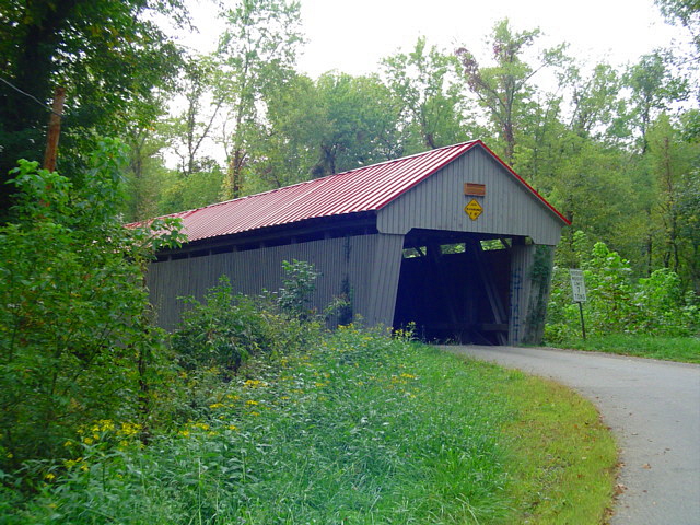
200:, which carries Mound Hill Road over Raccoon Creek north of
147:
39° 10′ 16″ N, 82° 20′ 13″ W
907:
Vinton (lungsod sa
Tinipong Bansa, Ohio, Vinton County)
419:
Add a one-line explanation of what this file represents
971:
966:
697:
https://www.flickr.com/photos/24304517@N02/3964707656
180:
90:
Commons is a freely licensed media file repository.
607:
Creative
Commons Attribution-ShareAlike 2.0 Generic
56:(640 × 480 pixels, file size: 233 KB, MIME type:
344:https://creativecommons.org/licenses/by-sa/2.0
196:Northwestern end and northeastern side of the
71:
947:Município de Vinton (condado de Vinton, Ohio)
350:Creative Commons Attribution-Share Alike 2.0
274:
8:
310:– to copy, distribute and transmit the work
999:
806:
506:https://www.flickr.com/people/24304517@N02
415:
927:Vinton udalerria, Vinton konderria (Ohio)
899:The following other wikis use this file:
1238:
1228:
1220:
1210:
1202:
1194:
1184:
1174:
1166:
1156:
1148:
1138:
1130:
1122:
1111:
1103:
1095:
1087:
1079:
1071:
1060:
1052:
1041:
1031:
1021:
1011:
866:
780:
764:
746:
730:
674:
658:
640:
624:
604:
588:
568:
552:
485:
469:
449:
433:
430:
411:
404:
140:
386:, was reviewed on 25 July 2010 by the
220:. Built in 1870, it is listed on the
161:View this and other nearby images on:
1001:
864:The following 5 pages use this file:
7:
889:Vinton Township, Vinton County, Ohio
222:National Register of Historic Places
118:National Register of Historic Places
795:
380:
378:
297:Attribution-Share Alike 2.0 Generic
285:
280:
992:
937:بخش وینتون، شهرستان وینتون، اوهایو
424:
418:
271:
190:
103:
49:
423:
376:This image, originally posted to
1054:Date and time of data generation
733:coordinates of the point of view
409:
369:
321:Under the following conditions:
292:This file is licensed under the
284:
279:
273:
167:
153:
108:
70:
31:
21:
879:List of covered bridges in Ohio
406:
191:
46:No higher resolution available.
14:
748:39°10'16.000"N, 82°20'12.998"W
677:file available on the internet
405:
26:
1:
186:Eakin Mill Covered Bridge.jpg
52:Eakin_Mill_Covered_Bridge.jpg
36:
957:Xã Vinton, Quận Vinton, Ohio
431:Items portrayed in this file
1124:Date and time of digitizing
903:Usage on ceb.wikipedia.org
1262:
978:Usage on zh.wikipedia.org
963:Usage on www.wikidata.org
953:Usage on vi.wikipedia.org
943:Usage on pt.wikipedia.org
933:Usage on fa.wikipedia.org
923:Usage on eu.wikipedia.org
917:Municipio de Vinton (Ohio)
913:Usage on es.wikipedia.org
335:same or compatible license
124:. Its reference number is
1089:File change date and time
869:Eakin Mill Covered Bridge
796:
452:Eakin Mill Covered Bridge
198:Eakin Mill Covered Bridge
16:
1127:09:15, 20 September 2009
1092:09:15, 20 September 2009
1057:09:15, 20 September 2009
408:
301:
122:United States of America
77:This is a file from the
1196:Custom image processing
853:
259:
249:
239:
232:
229:
183:
81:. Information from its
1132:Image compression mode
173:39.171111; -82.336944
84:description page there
1150:Maximum land aperture
1073:Horizontal resolution
767:location of creation
1153:3.875 APEX (f/3.83)
1097:Y and C positioning
1081:Vertical resolution
1003:Camera manufacturer
832:12:32, 23 July 2010
316:– to adapt the work
1222:Scene capture type
1217:Auto white balance
1181:Flash did not fire
514:author name string
1249:
1248:
1028:1/125 sec (0.008)
895:Global file usage
857:
642:20 September 2009
591:copyright license
417:
403:
402:
363:
362:
268:
265:Reusing this file
234:20 September 2009
178:
177:
136:
135:
99:
98:
79:Wikimedia Commons
32:Global file usage
1253:
1105:Exposure Program
1000:
844:
714:
709:
699:
694:
690:described at URL
555:copyright status
536:
531:
521:
518:
508:
503:
384:
382:
373:
372:
366:
357:
354:
351:
348:
345:
337:as the original.
294:Creative Commons
288:
287:
283:
282:
277:
276:
262:
235:
195:
187:
181:
174:
171:
157:
156:
150:
149:
138:
129:
112:
111:
105:
95:
74:
73:
67:
61:
59:
1261:
1260:
1256:
1255:
1254:
1252:
1251:
1250:
988:
893:
858:
850:
842:
798:
797:
794:
793:
792:
791:
790:
789:
788:
787:
785:
773:
772:
771:
769:
758:
757:
756:
755:
754:
753:
752:
751:
749:
739:
738:
737:
735:
724:
723:
722:
721:
720:
719:
718:
717:
716:
715:
710:
707:
701:
700:
695:
692:
683:
682:
681:
679:
667:
666:
665:
663:
652:
651:
650:
649:
648:
647:
646:
645:
643:
633:
632:
631:
629:
618:
617:
616:
615:
614:
613:
612:
611:
609:
597:
596:
595:
593:
582:
581:
580:
579:
578:
577:
576:
575:
573:
561:
560:
559:
557:
546:
545:
544:
543:
542:
541:
540:
539:
538:
537:
532:
529:
523:
522:
519:
516:
510:
509:
504:
501:
492:
491:
490:
488:
478:
477:
476:
474:
463:
462:
461:
460:
459:
458:
457:
456:
454:
442:
441:
440:
438:
422:
421:
420:
370:
364:
359:
358:
355:
352:
349:
346:
343:
342:
300:
289:
225:
206:Vinton Township
185:
172:
145:
144:
141:Camera location
125:
109:
101:
100:
89:
88:
87:is shown below.
63:
57:
55:
48:
47:
12:
11:
5:
1259:
1257:
1247:
1246:
1243:
1237:
1236:
1233:
1227:
1226:
1223:
1219:
1218:
1215:
1209:
1208:
1205:
1201:
1200:
1199:Normal process
1197:
1193:
1192:
1189:
1183:
1182:
1179:
1173:
1172:
1169:
1165:
1164:
1161:
1155:
1154:
1151:
1147:
1146:
1143:
1137:
1136:
1133:
1129:
1128:
1125:
1121:
1120:
1117:
1110:
1109:
1108:Normal program
1106:
1102:
1101:
1098:
1094:
1093:
1090:
1086:
1085:
1082:
1078:
1077:
1074:
1070:
1069:
1066:
1059:
1058:
1055:
1051:
1050:
1047:
1040:
1039:
1036:
1030:
1029:
1026:
1020:
1019:
1014:
1010:
1009:
1004:
991:
987:
986:
985:
984:
976:
975:
974:
969:
961:
960:
959:
951:
950:
949:
941:
940:
939:
931:
930:
929:
921:
920:
919:
911:
910:
909:
897:
896:
892:
891:
886:
881:
876:
871:
862:
861:
856:
855:
852:
848:
845:
839:
834:
829:
825:
824:
821:
818:
815:
812:
809:
802:
801:
786:
781:
779:
778:
777:
776:
775:
774:
770:
765:
763:
762:
761:
760:
759:
750:
747:
745:
744:
743:
742:
741:
740:
736:
731:
729:
728:
727:
726:
703:
702:
688:
687:
686:
685:
684:
680:
675:
673:
672:
671:
670:
669:
668:
664:
661:source of file
659:
657:
656:
655:
654:
653:
644:
641:
639:
638:
637:
636:
635:
634:
630:
625:
623:
622:
621:
620:
619:
610:
605:
603:
602:
601:
600:
599:
598:
594:
589:
587:
586:
585:
584:
583:
574:
569:
567:
566:
565:
564:
563:
562:
558:
553:
551:
550:
549:
548:
547:
527:Flickr user ID
525:
524:
512:
511:
497:
496:
495:
494:
493:
489:
486:
484:
483:
482:
481:
480:
479:
475:
470:
468:
467:
466:
465:
464:
455:
450:
448:
447:
446:
445:
444:
443:
439:
434:
432:
429:
428:
427:
426:
425:
414:
413:
410:
407:
401:
400:
374:
361:
360:
341:
340:
339:
338:
328:
319:
318:
317:
311:
304:You are free:
291:
290:
272:
269:
257:
256:
251:
247:
246:
241:
237:
236:
231:
227:
226:
188:
179:
176:
175:
165:
159:
142:
134:
133:
113:
102:
97:
96:
75:
65:
64:
45:
41:
40:
39:
34:
29:
24:
19:
13:
10:
9:
6:
4:
3:
2:
1258:
1244:
1242:
1239:
1234:
1232:
1229:
1224:
1221:
1216:
1214:
1213:White balance
1211:
1207:Auto exposure
1206:
1204:Exposure mode
1203:
1198:
1195:
1190:
1188:
1185:
1180:
1178:
1175:
1170:
1167:
1162:
1160:
1159:Metering mode
1157:
1152:
1149:
1144:
1142:
1141:Exposure bias
1139:
1134:
1131:
1126:
1123:
1118:
1115:
1112:
1107:
1104:
1099:
1096:
1091:
1088:
1083:
1080:
1075:
1072:
1067:
1065:
1061:
1056:
1053:
1048:
1045:
1042:
1037:
1035:
1032:
1027:
1025:
1024:Exposure time
1022:
1018:
1015:
1012:
1008:
1005:
1002:
998:
995:
989:
983:
980:
979:
977:
973:
970:
968:
965:
964:
962:
958:
955:
954:
952:
948:
945:
944:
942:
938:
935:
934:
932:
928:
925:
924:
922:
918:
915:
914:
912:
908:
905:
904:
902:
901:
900:
894:
890:
887:
885:
882:
880:
877:
875:
872:
870:
867:
865:
859:
851:
846:
840:
838:
835:
833:
830:
827:
826:
822:
819:
816:
813:
810:
808:
807:
805:
799:
784:
768:
734:
713:
706:
698:
691:
678:
662:
628:
608:
592:
572:
556:
535:
528:
515:
507:
500:
473:
453:
437:
398:
397:
393:
389:
388:administrator
385:
383:
375:
368:
367:
347:CC BY-SA 2.0
336:
332:
329:
326:
323:
322:
320:
315:
312:
309:
306:
305:
303:
302:
298:
295:
278:
270:
266:
261:
258:
255:
252:
248:
245:
242:
238:
228:
223:
219:
218:United States
215:
211:
210:Vinton County
207:
203:
199:
194:
189:
182:
170:
166:
164:
163:OpenStreetMap
160:
158:
148:
143:
139:
132:
131:
128:
123:
119:
114:
107:
106:
93:
86:
85:
80:
76:
69:
68:
62:
53:
44:
38:
35:
33:
30:
28:
25:
23:
20:
18:
15:
1168:Light source
1064:focal length
1013:Camera model
996:
993:
898:
863:
803:
800:File history
534:24304517@N02
394:
377:
330:
324:
313:
307:
192:
115:
92:You can help
82:
50:
22:File history
1187:Color space
571:copyrighted
331:share alike
325:attribution
184:Description
860:File usage
841:640 × 480
817:Dimensions
487:some value
396:Wikitanvir
260:Permission
58:image/jpeg
27:File usage
1241:Sharpness
1044:ISO speed
814:Thumbnail
811:Date/Time
627:inception
193:English:
1231:Contrast
1225:Standard
1100:Co-sited
1034:F-number
990:Metadata
972:Q7932904
967:Q5325436
843:(233 KB)
705:operator
412:Captions
392:reviewer
314:to remix
308:to share
299:license.
127:76001539
37:Metadata
1171:Unknown
1163:Pattern
1116:version
1017:DSC-P52
849:Nyttend
828:current
823:Comment
472:creator
436:depicts
416:English
202:Arbaugh
120:in the
54:
1235:Normal
1084:72 dpi
1076:72 dpi
1068:8.2 mm
1046:rating
712:Flickr
381:Flickr
250:Author
244:Flickr
240:Source
151:
1177:Flash
1062:Lens
1038:f/3.8
520:tcpix
254:tcpix
1245:Hard
1191:sRGB
1114:Exif
1007:SONY
820:User
783:Ohio
356:true
353:true
230:Date
214:Ohio
17:File
1119:2.2
1049:100
499:URL
390:or
204:in
708::
693::
530::
517::
502::
216:,
212:,
208:,
1145:0
1135:4
267:)
263:(
224:.
130:.
94:.
60:)
Text is available under the Creative Commons Attribution-ShareAlike License. Additional terms may apply.