386:
319:
269:
311:
261:
333:
283:
354:
392:
397:
72:
917:"}},"text\/plain":{"en":{"":"heading"}}},"{\"value\":{\"amount\":\"+247\",\"unit\":\"http:\\\/\\\/www.wikidata.org\\\/entity\\\/Q28390\"},\"type\":\"quantity\"}":{"text\/html":{"en":{"P7787":"247
817:"}},"text\/plain":{"en":{"":"heading"}}},"{\"value\":{\"amount\":\"+247\",\"unit\":\"http:\\\/\\\/www.wikidata.org\\\/entity\\\/Q28390\"},\"type\":\"quantity\"}":{"text\/html":{"en":{"P7787":"247
813:
302:
252:
43:
444:– You must give appropriate credit, provide a link to the license, and indicate if changes were made. You may do so in any reasonable manner, but not in any way that suggests the licensor endorses you or your use.
51:
914:
814:
83:
1092:
1169:
1102:
1097:
189:
715:
679:
643:
524:
326:
276:
900:
735:
361:
1133:
This file contains additional information, probably added from the digital camera or scanner used to create or digitize it.
451:
1063:
578:
984:
955:
928:
884:
855:
828:
743:
699:
627:
599:
586:
571:
786:
758:
728:
663:
544:
508:
1052:
1047:
42:
348:
407:
1136:
If the file has been modified from its original state, some details may not fully reflect the modified file.
1083:
The following pages on the
English Knowledge (XXG) use this file (pages on other projects are not listed):
450:– If you remix, transform, or build upon the material, you must distribute your contributions under the
368:
on the
Geograph website for the photographer's contact details. The copyright on this image is owned by
404:
120:
921:"}},"text\/plain":{"en":{"P7787":"247 degree"}}}}": -->
821:"}},"text\/plain":{"en":{"P7787":"247 degree"}}}}": -->
91:
221:
115:
765:
750:
606:
205:
332:
282:
1071:
373:
78:
1087:
1184:
266:
157:
316:
178:
168:
353:
365:
1020:
Click on a date/time to view the file as it appeared at that time.
318:
268:
253:
52° 27′ 28.12″ N, 1° 23′ 54.05″ E
293:
243:
66:
303:
52° 27′ 26.9″ N, 1° 23′ 45″ E
492:
Add a one-line explanation of what this file represents
1120:
196:
Creative
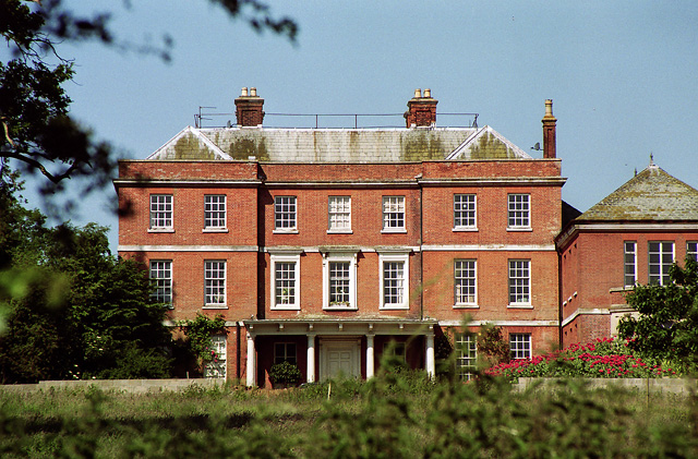
Commons Attribution Share-alike license 2.0
132:
109:
90:
Commons is a freely licensed media file repository.
680:
Creative
Commons Attribution-ShareAlike 2.0 Generic
56:(640 × 421 pixels, file size: 199 KB, MIME type:
461:https://creativecommons.org/licenses/by-sa/2.0
71:
467:Creative Commons Attribution-Share Alike 2.0
385:
8:
138:Earsham Hall, Earsham (geograph 3396891).jpg
52:Earsham_Hall,_Earsham_(geograph_3396891).jpg
1093:Grade II* listed buildings in South Norfolk
918:
818:
427:– to copy, distribute and transmit the work
1138:
1022:
488:
1113:The following other wikis use this file:
766:https://www.geograph.org.uk/photo/3396891
607:https://www.geograph.org.uk/profile/34784
1229:xmp.did:88006F1A2635E01191F8AAD3C660A09A
1232:
1224:
1216:
1208:
1200:
1192:
1182:
1174:
1164:
1156:
1148:
1140:
1085:
998:
982:
942:
926:
898:
882:
842:
826:
800:
784:
713:
697:
677:
661:
641:
625:
558:
542:
522:
506:
503:
484:
477:
296:
246:
325:View this and other nearby images on:
275:View this and other nearby images on:
7:
1170:Adobe Photoshop Elements 8.0 Windows
1103:William Windham (of Earsham, senior)
1098:William Windham (of Earsham, junior)
372:and is licensed for reuse under the
1011:
408:Attribution-Share Alike 2.0 Generic
396:
391:
376:Attribution-ShareAlike 2.0 license.
1131:
497:
491:
382:
359:
142:
113:
103:
49:
496:
829:coordinates of the point of view
482:
438:Under the following conditions:
403:This file is licensed under the
395:
390:
384:
352:
331:
317:
309:
281:
267:
259:
70:
31:
21:
1218:Date metadata was last modified
1065:File Upload Bot (Magnus Manske)
479:
143:
46:No higher resolution available.
14:
1226:Unique ID of original document
716:file available on the internet
478:
360:This image was taken from the
26:
1:
1070:Transferred from Geograph by
929:coordinates of depicted place
844:52°27'28.120"N, 1°23'54.049"E
234:Stephen Richards /
215:Stephen Richards /
36:
736:Geograph Britain and Ireland
572:object of statement has role
504:Items portrayed in this file
308:
258:
1210:Date and time of digitizing
944:52°27'26.93"N, 1°23'44.52"E
1254:
1117:Usage on www.wikidata.org
452:same or compatible license
1176:File change date and time
1012:
16:
744:geograph.org.uk image ID
481:
418:
77:This is a file from the
1213:16:44, 10 February 2011
1069:
206:required by the license
184:
174:
163:
156:
153:
135:
81:. Information from its
366:this photograph's page
337:52.457480; 1.395700
287:52.457811; 1.398347
84:description page there
1150:Horizontal resolution
236:Earsham Hall, Earsham
217:Earsham Hall, Earsham
148:Earsham Hall, Earsham
1048:14:18, 25 March 2014
885:location of creation
1221:17:16, 4 April 2013
1179:16:16, 4 April 2013
1158:Vertical resolution
433:– to adapt the work
114:This is a photo of
587:author name string
1241:
1240:
1109:Global file usage
1076:
920:
820:
664:copyright license
490:
381:
380:
364:collection. See
342:
341:
292:
291:
241:
240:
209:
193:
190:Reusing this file
130:
129:
99:
98:
79:Wikimedia Commons
32:Global file usage
1245:
1139:
1060:
966:
965:
960:
866:
865:
860:
768:
763:
759:described at URL
753:
748:
738:
733:
628:copyright status
609:
604:
594:
593:Stephen Richards
591:
581:
576:
474:
471:
468:
465:
462:
454:as the original.
416:
415:Stephen Richards
405:Creative Commons
399:
398:
394:
393:
388:
387:
374:Creative Commons
370:Stephen Richards
362:Geograph project
356:
349:
338:
335:
321:
320:
314:
313:
312:
306:
305:
294:
288:
285:
271:
270:
264:
263:
262:
256:
255:
244:
203:
187:
179:Stephen Richards
159:
147:
139:
133:
123:
110:
95:
74:
73:
67:
61:
59:
1253:
1252:
1248:
1247:
1246:
1244:
1243:
1242:
1127:
1107:
1084:
1077:
1066:
1058:
1014:
1013:
1010:
1009:
1008:
1007:
1006:
1005:
1004:
1003:
1001:
991:
990:
989:
987:
976:
975:
974:
973:
972:
971:
970:
969:
968:
967:
963:
961:
958:
949:
948:
947:
945:
935:
934:
933:
931:
912:
911:
910:
909:
908:
907:
906:
905:
903:
891:
890:
889:
887:
876:
875:
874:
873:
872:
871:
870:
869:
868:
867:
863:
861:
858:
849:
848:
847:
845:
835:
834:
833:
831:
812:
811:
810:
809:
808:
807:
806:
805:
803:
793:
792:
791:
789:
778:
777:
776:
775:
774:
773:
772:
771:
770:
769:
764:
761:
755:
754:
749:
746:
740:
739:
734:
731:
722:
721:
720:
718:
706:
705:
704:
702:
691:
690:
689:
688:
687:
686:
685:
684:
682:
670:
669:
668:
666:
655:
654:
653:
652:
651:
650:
649:
648:
646:
634:
633:
632:
630:
619:
618:
617:
616:
615:
614:
613:
612:
611:
610:
605:
602:
596:
595:
592:
589:
583:
582:
577:
574:
565:
564:
563:
561:
551:
550:
549:
547:
536:
535:
534:
533:
532:
531:
530:
529:
527:
515:
514:
513:
511:
495:
494:
493:
476:
475:
472:
469:
466:
463:
460:
459:
417:
414:
411:
400:
377:
347:
336:
310:
301:
300:
297:Object location
286:
260:
251:
250:
247:Camera location
242:
231:
224:
212:
169:geograph.org.uk
149:
137:
125:
119:
116:listed building
108:
101:
100:
89:
88:
87:is shown below.
63:
57:
55:
48:
47:
12:
11:
5:
1251:
1249:
1239:
1238:
1235:
1231:
1230:
1227:
1223:
1222:
1219:
1215:
1214:
1211:
1207:
1206:
1203:
1199:
1198:
1195:
1191:
1190:
1187:
1181:
1180:
1177:
1173:
1172:
1167:
1163:
1162:
1159:
1155:
1154:
1151:
1147:
1146:
1143:
1130:
1126:
1125:
1124:
1123:
1111:
1110:
1106:
1105:
1100:
1095:
1090:
1082:
1081:
1080:
1075:
1074:
1068:
1064:
1061:
1055:
1050:
1045:
1041:
1040:
1037:
1034:
1031:
1028:
1025:
1018:
1017:
1002:
999:
997:
996:
995:
994:
993:
992:
988:
983:
981:
980:
979:
978:
977:
954:
953:
952:
951:
950:
946:
943:
941:
940:
939:
938:
937:
936:
932:
927:
925:
924:
923:
922:
916:
904:
899:
897:
896:
895:
894:
893:
892:
888:
883:
881:
880:
879:
878:
877:
854:
853:
852:
851:
850:
846:
843:
841:
840:
839:
838:
837:
836:
832:
827:
825:
824:
823:
822:
816:
804:
801:
799:
798:
797:
796:
795:
794:
790:
785:
783:
782:
781:
780:
779:
757:
756:
742:
741:
727:
726:
725:
724:
723:
719:
714:
712:
711:
710:
709:
708:
707:
703:
700:source of file
698:
696:
695:
694:
693:
692:
683:
678:
676:
675:
674:
673:
672:
671:
667:
662:
660:
659:
658:
657:
656:
647:
642:
640:
639:
638:
637:
636:
635:
631:
626:
624:
623:
622:
621:
620:
598:
597:
585:
584:
570:
569:
568:
567:
566:
562:
559:
557:
556:
555:
554:
553:
552:
548:
543:
541:
540:
539:
538:
537:
528:
523:
521:
520:
519:
518:
517:
516:
512:
507:
505:
502:
501:
500:
499:
498:
487:
486:
483:
480:
458:
457:
456:
455:
445:
436:
435:
434:
428:
421:You are free:
412:
402:
401:
383:
379:
378:
357:
346:
343:
340:
339:
329:
323:
298:
290:
289:
279:
273:
248:
239:
238:
232:
229:
226:
225:
220:
213:
210:
198:
197:
194:
182:
181:
176:
172:
171:
165:
161:
160:
155:
151:
150:
140:
131:
128:
127:
107:
104:
102:
97:
96:
75:
65:
64:
45:
41:
40:
39:
34:
29:
24:
19:
13:
10:
9:
6:
4:
3:
2:
1250:
1236:
1233:
1228:
1225:
1220:
1217:
1212:
1209:
1204:
1201:
1196:
1193:
1188:
1186:
1183:
1178:
1175:
1171:
1168:
1166:Software used
1165:
1160:
1157:
1152:
1149:
1144:
1141:
1137:
1134:
1128:
1122:
1119:
1118:
1116:
1115:
1114:
1108:
1104:
1101:
1099:
1096:
1094:
1091:
1089:
1086:
1078:
1073:
1072:User:plucas58
1067:
1062:
1056:
1054:
1051:
1049:
1046:
1043:
1042:
1038:
1035:
1032:
1029:
1026:
1024:
1023:
1021:
1015:
986:
957:
930:
902:
901:South Norfolk
886:
857:
830:
788:
767:
760:
752:
745:
737:
730:
717:
701:
681:
665:
645:
629:
608:
601:
588:
580:
573:
546:
526:
510:
464:CC BY-SA 2.0
453:
449:
446:
443:
440:
439:
437:
432:
429:
426:
423:
422:
420:
419:
413:Attribution:
409:
406:
389:
375:
371:
367:
363:
358:
355:
351:
350:
344:
334:
330:
328:
327:OpenStreetMap
324:
322:
304:
299:
295:
284:
280:
278:
277:OpenStreetMap
274:
272:
254:
249:
245:
237:
233:
228:
227:
223:
219: /
218:
214:
207:
202:
200:
199:
195:
191:
186:
183:
180:
177:
173:
170:
166:
162:
152:
146:
141:
134:
126:
122:
117:
112:
111:
105:
93:
86:
85:
80:
76:
69:
68:
62:
53:
44:
38:
35:
33:
30:
28:
25:
23:
20:
18:
15:
1202:Image height
1135:
1132:
1112:
1088:Earsham Hall
1019:
1016:File history
802:17 June 2002
579:photographer
525:Earsham Hall
447:
441:
430:
424:
369:
307:
257:
235:
222:CC BY-SA 2.0
216:
158:17 June 2002
144:
92:You can help
82:
50:
22:File history
1234:IIM version
1194:Image width
1185:Color space
1142:Orientation
644:copyrighted
448:share alike
442:attribution
201:Attribution
136:Description
1079:File usage
1057:640 × 421
1033:Dimensions
1000:image/jpeg
985:media type
560:some value
185:Permission
58:image/jpeg
27:File usage
1121:Q17531622
1030:Thumbnail
1027:Date/Time
787:inception
345:Licensing
230:InfoField
211:InfoField
145:English:
1129:Metadata
1059:(199 KB)
729:operator
485:Captions
431:to remix
425:to share
410:license.
37:Metadata
1161:300 dpi
1153:300 dpi
1044:current
1039:Comment
956:heading
915:heading
856:heading
815:heading
751:3396891
545:creator
509:depicts
489:English
121:1050397
118:number
106:Summary
54:
1237:15,984
1205:421 px
1197:640 px
1145:Normal
964:degree
919:degree
864:degree
819:degree
315:
265:
175:Author
164:Source
167:From
1189:sRGB
1036:User
962:247
862:247
473:true
470:true
154:Date
17:File
600:URL
959::
859::
762::
747::
732::
603::
590::
575::
208:)
204:(
192:)
188:(
124:.
94:.
60:)
Text is available under the Creative Commons Attribution-ShareAlike License. Additional terms may apply.
.jpg)
.jpg¶ms=052.457811_N_0001.398347_E_globe:Earth_type:camera_heading:247.00_source:geograph&language=en)
.jpg¶ms=052.457480_N_0001.395700_E_globe:Earth_class:object_type:object_source:geograph-osgb36(TM30808981)_region:GB-GBN_heading:247.00&language=en)
