43:
289:
295:
300:
258:
99:
707:
677:
647:
341:– You must give appropriate credit, provide a link to the license, and indicate if changes were made. You may do so in any reasonable manner, but not in any way that suggests the licensor endorses you or your use.
193:
65:
61:
57:
53:
47:
110:
154:
78:
558:
522:
774:
This file contains additional information, probably added from the digital camera or scanner used to create or digitize it.
348:
706:
701:
676:
671:
506:
478:
465:
450:
578:
542:
423:
406:
485:
310:
777:
If the file has been modified from its original state, some details may not fully reflect the modified file.
738:
347:– If you remix, transform, or build upon the material, you must distribute your contributions under the
307:
734:
The following pages on the
English Knowledge use this file (pages on other projects are not listed):
457:
646:
641:
118:
69:
42:
264:
743:
717:
687:
657:
189:
805:
158:
694:
Adding missing labels for
Westlake and Pioneer Square; adjusted SR 520 shield in Overlake
247:
105:
282:
I, the copyright holder of this work, hereby publish it under the following license:
214:
231:
235:
227:
204:
174:
223:
218:
614:
Click on a date/time to view the file as it appeared at that time.
162:
268:
257:
761:
93:
199:
559:
Creative
Commons Attribution-ShareAlike 4.0 International
390:
Add a one-line explanation of what this file represents
83:(2,538 × 1,501 pixels, file size: 1.59 MB, MIME type:
137:
117:
Commons is a freely licensed media file repository.
458:https://commons.wikimedia.org/user:SounderBruce
358:https://creativecommons.org/licenses/by-sa/4.0
98:
364:Creative Commons Attribution-Share Alike 4.0
288:
194:Washington State Department of Transportation
8:
324:– to copy, distribute and transmit the work
779:
616:
386:
754:The following other wikis use this file:
311:Attribution-Share Alike 4.0 International
802:
797:
789:
781:
736:
592:
576:
556:
540:
520:
504:
437:
421:
404:
401:
382:
375:
7:
724:User created page with UploadWizard
605:
299:
294:
772:
395:
389:
285:
281:
262:
147:
130:
76:
394:
380:
335:Under the following conditions:
306:This file is licensed under the
298:
293:
287:
256:
97:
31:
21:
377:
148:
143:East Link map with stations.png
14:
664:Less prominent location labels
376:
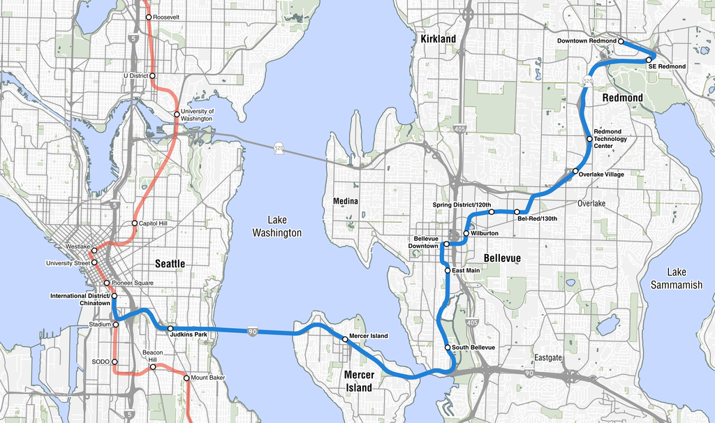
26:
1:
36:
402:Items portrayed in this file
827:
758:Usage on de.wikipedia.org
349:same or compatible license
606:
200:City of Seattle Open Data
16:
379:
315:
157:, an under construction
104:This is a file from the
723:
693:
663:
243:
180:
173:
170:
165:to its eastern suburbs.
161:line that will connect
140:
108:. Information from its
739:2 Line (Sound Transit)
702:08:33, 28 January 2018
672:02:26, 29 January 2018
642:02:37, 7 February 2018
205:King County GIS Center
111:description page there
46:Size of this preview:
783:Horizontal resolution
190:WSDOT GIS Data Center
70:2,538 × 1,501 pixels
791:Vertical resolution
330:– to adapt the work
155:East Link Extension
52:Other resolutions:
479:Wikimedia username
466:author name string
66:1,280 × 757 pixels
62:1,024 × 606 pixels
814:
813:
762:Stadtbahn Seattle
750:Global file usage
744:User:SounderBruce
727:
543:copyright license
388:
267:was created with
253:
252:
210:Highway shields:
126:
125:
106:Wikimedia Commons
32:Global file usage
818:
808:
806:paint.net 4.0.21
780:
714:
684:
654:
507:copyright status
488:
483:
473:
470:
460:
455:
371:
368:
365:
362:
359:
351:as the original.
308:Creative Commons
302:
301:
297:
296:
291:
290:
260:
176:
152:
144:
138:
122:
101:
100:
94:
88:
86:
73:
58:640 × 379 pixels
54:320 × 189 pixels
48:800 × 473 pixels
826:
825:
821:
820:
819:
817:
816:
815:
804:
768:
748:
735:
728:
720:
712:
690:
682:
660:
652:
608:
607:
604:
603:
602:
601:
600:
599:
598:
597:
595:
594:28 January 2018
585:
584:
583:
581:
570:
569:
568:
567:
566:
565:
564:
563:
561:
549:
548:
547:
545:
534:
533:
532:
531:
530:
529:
528:
527:
525:
513:
512:
511:
509:
498:
497:
496:
495:
494:
493:
492:
491:
490:
489:
484:
481:
475:
474:
471:
468:
462:
461:
456:
453:
444:
443:
442:
440:
430:
429:
428:
426:
415:
414:
413:
412:
411:
409:
393:
392:
391:
374:
373:
372:
369:
366:
363:
360:
357:
356:
314:
303:
284:
283:
278:
273:
272:
254:
215:File:WA-520.svg
175:28 January 2018
166:
159:Link light rail
142:
135:
128:
127:
116:
115:
114:is shown below.
90:
84:
82:
75:
74:
51:
12:
11:
5:
824:
822:
812:
811:
810:
809:
800:
796:
795:
792:
788:
787:
784:
771:
767:
766:
765:
764:
752:
751:
747:
746:
741:
733:
732:
731:
726:
725:
722:
718:
715:
711:2,538 × 1,501
709:
704:
699:
696:
695:
692:
688:
685:
681:2,538 × 1,501
679:
674:
669:
666:
665:
662:
658:
655:
651:2,538 × 1,501
649:
644:
639:
635:
634:
631:
628:
625:
622:
619:
612:
611:
596:
593:
591:
590:
589:
588:
587:
586:
582:
577:
575:
574:
573:
572:
571:
562:
557:
555:
554:
553:
552:
551:
550:
546:
541:
539:
538:
537:
536:
535:
526:
521:
519:
518:
517:
516:
515:
514:
510:
505:
503:
502:
501:
500:
499:
477:
476:
464:
463:
449:
448:
447:
446:
445:
441:
438:
436:
435:
434:
433:
432:
431:
427:
422:
420:
419:
418:
417:
416:
410:
405:
403:
400:
399:
398:
397:
396:
385:
384:
381:
378:
355:
354:
353:
352:
342:
333:
332:
331:
325:
318:You are free:
305:
304:
286:
280:
279:
277:
274:
255:
251:
250:
245:
241:
240:
239:
238:
232:File:I-405.svg
221:
208:
207:
202:
197:
182:
178:
177:
172:
168:
167:
145:
136:
134:
131:
129:
124:
123:
102:
92:
91:
45:
41:
40:
39:
34:
29:
24:
19:
13:
10:
9:
6:
4:
3:
2:
823:
807:
803:
801:
799:Software used
798:
793:
790:
785:
782:
778:
775:
769:
763:
760:
759:
757:
756:
755:
749:
745:
742:
740:
737:
729:
721:
716:
710:
708:
705:
703:
700:
698:
697:
691:
686:
680:
678:
675:
673:
670:
668:
667:
661:
656:
650:
648:
645:
643:
640:
637:
636:
632:
629:
626:
623:
620:
618:
617:
615:
609:
580:
560:
544:
524:
508:
487:
480:
467:
459:
452:
425:
408:
361:CC BY-SA 4.0
350:
346:
343:
340:
337:
336:
334:
329:
326:
323:
320:
319:
317:
316:
312:
309:
292:
275:
270:
266:
259:
249:
246:
242:
237:
233:
229:
228:File:I-90.svg
225:
222:
220:
216:
213:
212:
211:
206:
203:
201:
198:
195:
191:
188:
187:
186:
183:
179:
169:
164:
160:
156:
153:A map of the
151:
146:
139:
132:
120:
113:
112:
107:
103:
96:
95:
89:
80:
79:Original file
71:
67:
63:
59:
55:
49:
44:
38:
35:
33:
30:
28:
25:
23:
20:
18:
15:
776:
773:
753:
719:SounderBruce
689:SounderBruce
659:SounderBruce
613:
610:File history
486:SounderBruce
472:SounderBruce
344:
338:
327:
321:
248:SounderBruce
224:File:I-5.svg
209:
184:
149:
119:You can help
109:
77:
22:File history
523:copyrighted
345:share alike
339:attribution
141:Description
730:File usage
627:Dimensions
439:some value
263:This PNG
185:GIS data:
27:File usage
794:118.1 dpc
786:118.1 dpc
713:(1.58 MB)
683:(1.58 MB)
653:(1.59 MB)
624:Thumbnail
621:Date/Time
579:inception
276:Licensing
150:English:
85:image/png
770:Metadata
383:Captions
328:to remix
322:to share
313:license.
236:Ltljltlj
37:Metadata
638:current
633:Comment
424:creator
407:depicts
387:English
265:graphic
163:Seattle
133:Summary
81:
261:
244:Author
230:, and
219:PHenry
181:Source
630:User
370:true
367:true
269:QGIS
171:Date
17:File
451:URL
234:by
217:by
482::
469::
454::
226:,
68:|
64:|
60:|
56:|
50:.
271:.
196:)
192:(
121:.
87:)
72:.
Text is available under the Creative Commons Attribution-ShareAlike License. Additional terms may apply.
