349:
282:
232:
274:
224:
296:
246:
317:
355:
360:
72:
861:"}},"text\/plain":{"en":{"":"heading"}}},"{\"value\":{\"amount\":\"+135\",\"unit\":\"http:\\\/\\\/www.wikidata.org\\\/entity\\\/Q28390\"},\"type\":\"quantity\"}":{"text\/html":{"en":{"P7787":"135
761:"}},"text\/plain":{"en":{"":"heading"}}},"{\"value\":{\"amount\":\"+135\",\"unit\":\"http:\\\/\\\/www.wikidata.org\\\/entity\\\/Q28390\"},\"type\":\"quantity\"}":{"text\/html":{"en":{"P7787":"135
857:
265:
126:
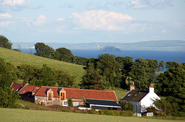
East Neuk The East Neuk of Fife, looking out over the River Forth to East
Lothian. With the Bass Rock in the centre. To the left of the Bass rock is Oxwell Mains cement plant at Dunbar and further to the left at the 2nd last tree can be seen Torness power
1014:== {{int:filedesc}} == {{Information |description={{en|1=East Neuk The East Neuk of Fife, looking out over the River Forth to East Lothian. With the Bass Rock in the centre. To the left of the Bass rock is Oxwell Mains cement plant at Dunbar and further t
215:
407:– You must give appropriate credit, provide a link to the license, and indicate if changes were made. You may do so in any reasonable manner, but not in any way that suggests the licensor endorses you or your use.
43:
858:
758:
83:
51:
844:
693:
623:
587:
289:
239:
743:
324:
1099:
This file contains additional information, probably added from the digital camera or scanner used to create or digitize it.
414:
522:
928:
899:
872:
828:
799:
772:
721:
677:
571:
545:
530:
515:
736:
706:
643:
607:
488:
471:
311:
370:
1102:
If the file has been modified from its original state, some details may not fully reflect the modified file.
996:
991:
42:
413:– If you remix, transform, or build upon the material, you must distribute your contributions under the
331:
on the
Geograph website for the photographer's contact details. The copyright on this image is owned by
1007:
367:
865:"}},"text\/plain":{"en":{"P7787":"135 degree"}}}}": -->
765:"}},"text\/plain":{"en":{"P7787":"135 degree"}}}}": -->
91:
184:
537:
728:
713:
168:
295:
245:
336:
78:
136:
279:
229:
1028:
157:
147:
316:
328:
964:
Click on a date/time to view the file as it appeared at that time.
281:
231:
256:
206:
66:
266:
56° 12′ 51″ N, 2° 53′ 10″ W
216:
56° 13′ 01″ N, 2° 53′ 29″ W
455:
Add a one-line explanation of what this file represents
1076:
1066:
1056:
1046:
1086:
110:
90:
Commons is a freely licensed media file repository.
624:
Creative
Commons Attribution-ShareAlike 2.0 Generic
56:(640 × 422 pixels, file size: 88 KB, MIME type:
424:https://creativecommons.org/licenses/by-sa/2.0
71:
430:Creative Commons Attribution-Share Alike 2.0
348:
8:
862:
762:
390:– to copy, distribute and transmit the work
1104:
966:
451:
1039:The following other wikis use this file:
538:https://www.geograph.org.uk/profile/26899
714:https://www.geograph.org.uk/photo/901554
116:East Neuk - geograph.org.uk - 901554.jpg
52:East_Neuk_-_geograph.org.uk_-_901554.jpg
1106:
1026:
942:
926:
886:
870:
842:
826:
786:
770:
691:
675:
657:
641:
621:
605:
585:
569:
502:
486:
469:
466:
447:
440:
259:
209:
288:View this and other nearby images on:
238:View this and other nearby images on:
7:
335:and is licensed for reuse under the
1024:The following page uses this file:
955:
371:Attribution-Share Alike 2.0 Generic
359:
354:
339:Attribution-ShareAlike 2.0 license.
1097:
460:
454:
345:
322:
120:
103:
49:
459:
773:coordinates of the point of view
445:
401:Under the following conditions:
366:This file is licensed under the
358:
353:
347:
315:
294:
280:
272:
244:
230:
222:
70:
31:
21:
442:
121:
46:No higher resolution available.
14:
694:file available on the internet
441:
323:This image was taken from the
26:
1:
873:coordinates of depicted place
36:
744:Geograph Britain and Ireland
516:object of statement has role
467:Items portrayed in this file
271:
221:
888:56°12'51.41"N, 2°53'10.32"W
197:Allister Combe /
178:Allister Combe /
1128:
1083:Usage on www.wikidata.org
1073:Usage on it.wikipedia.org
1063:Usage on eu.wikipedia.org
1053:Usage on es.wikipedia.org
1043:Usage on de.wikipedia.org
788:56°13'0.98"N, 2°53'29.04"W
415:same or compatible license
956:
16:
722:geograph.org.uk image ID
444:
381:
77:This is a file from the
1013:
992:19:19, 21 February 2011
169:required by the license
153:
142:
135:
132:
113:
81:. Information from its
329:this photograph's page
300:56.214280; -2.886200
250:56.216940; -2.891400
84:description page there
829:location of creation
396:– to adapt the work
546:author name string
1115:
1114:
1035:Global file usage
1017:
864:
764:
608:copyright license
453:
344:
343:
327:collection. See
305:
304:
255:
254:
204:
203:
172:
99:
98:
79:Wikimedia Commons
32:Global file usage
1119:
1105:
1004:
910:
909:
904:
810:
809:
804:
746:
741:
731:
726:
716:
711:
707:described at URL
572:copyright status
553:
550:
540:
535:
525:
520:
437:
434:
431:
428:
425:
417:as the original.
379:
368:Creative Commons
362:
361:
357:
356:
351:
350:
337:Creative Commons
325:Geograph project
319:
312:
301:
298:
284:
283:
277:
276:
275:
269:
268:
257:
251:
248:
234:
233:
227:
226:
225:
219:
218:
207:
166:
138:
125:
117:
111:
95:
74:
73:
67:
61:
59:
1127:
1126:
1122:
1121:
1120:
1118:
1117:
1116:
1093:
1033:
1018:
1010:
1002:
958:
957:
954:
953:
952:
951:
950:
949:
948:
947:
945:
935:
934:
933:
931:
920:
919:
918:
917:
916:
915:
914:
913:
912:
911:
907:
905:
902:
893:
892:
891:
889:
879:
878:
877:
875:
856:
855:
854:
853:
852:
851:
850:
849:
847:
835:
834:
833:
831:
820:
819:
818:
817:
816:
815:
814:
813:
812:
811:
807:
805:
802:
793:
792:
791:
789:
779:
778:
777:
775:
756:
755:
754:
753:
752:
751:
750:
749:
748:
747:
742:
739:
733:
732:
727:
724:
718:
717:
712:
709:
700:
699:
698:
696:
684:
683:
682:
680:
669:
668:
667:
666:
665:
664:
663:
662:
660:
650:
649:
648:
646:
635:
634:
633:
632:
631:
630:
629:
628:
626:
614:
613:
612:
610:
599:
598:
597:
596:
595:
594:
593:
592:
590:
578:
577:
576:
574:
563:
562:
561:
560:
559:
558:
557:
556:
555:
554:
551:
548:
542:
541:
536:
533:
527:
526:
521:
518:
509:
508:
507:
505:
495:
494:
493:
491:
480:
479:
478:
477:
476:
474:
458:
457:
456:
439:
438:
435:
432:
429:
426:
423:
422:
380:
377:
374:
363:
340:
310:
299:
273:
264:
263:
260:Object location
249:
223:
214:
213:
210:Camera location
205:
194:
187:
175:
148:geograph.org.uk
128:
115:
108:
101:
100:
89:
88:
87:is shown below.
63:
57:
55:
48:
47:
12:
11:
5:
1125:
1123:
1113:
1112:
1109:
1096:
1092:
1091:
1090:
1089:
1081:
1080:
1079:
1071:
1070:
1069:
1061:
1060:
1059:
1051:
1050:
1049:
1037:
1036:
1032:
1031:
1022:
1021:
1016:
1015:
1012:
1008:
1005:
999:
994:
989:
985:
984:
981:
978:
975:
972:
969:
962:
961:
946:
943:
941:
940:
939:
938:
937:
936:
932:
927:
925:
924:
923:
922:
921:
898:
897:
896:
895:
894:
890:
887:
885:
884:
883:
882:
881:
880:
876:
871:
869:
868:
867:
866:
860:
848:
843:
841:
840:
839:
838:
837:
836:
832:
827:
825:
824:
823:
822:
821:
798:
797:
796:
795:
794:
790:
787:
785:
784:
783:
782:
781:
780:
776:
771:
769:
768:
767:
766:
760:
735:
734:
720:
719:
705:
704:
703:
702:
701:
697:
692:
690:
689:
688:
687:
686:
685:
681:
678:source of file
676:
674:
673:
672:
671:
670:
661:
658:
656:
655:
654:
653:
652:
651:
647:
642:
640:
639:
638:
637:
636:
627:
622:
620:
619:
618:
617:
616:
615:
611:
606:
604:
603:
602:
601:
600:
591:
586:
584:
583:
582:
581:
580:
579:
575:
570:
568:
567:
566:
565:
564:
552:Allister Combe
544:
543:
529:
528:
514:
513:
512:
511:
510:
506:
503:
501:
500:
499:
498:
497:
496:
492:
487:
485:
484:
483:
482:
481:
475:
470:
468:
465:
464:
463:
462:
461:
450:
449:
446:
443:
421:
420:
419:
418:
408:
399:
398:
397:
391:
384:You are free:
378:Allister Combe
375:
365:
364:
346:
342:
341:
333:Allister Combe
320:
309:
306:
303:
302:
292:
286:
261:
253:
252:
242:
236:
211:
202:
201:
195:
192:
189:
188:
183:
176:
173:
161:
160:
158:Allister Combe
155:
151:
150:
144:
140:
139:
134:
130:
129:
118:
109:
107:
104:
102:
97:
96:
75:
65:
64:
45:
41:
40:
39:
34:
29:
24:
19:
13:
10:
9:
6:
4:
3:
2:
1124:
1110:
1107:
1103:
1100:
1094:
1088:
1085:
1084:
1082:
1078:
1075:
1074:
1072:
1068:
1065:
1064:
1062:
1058:
1055:
1054:
1052:
1048:
1045:
1044:
1042:
1041:
1040:
1034:
1030:
1027:
1025:
1019:
1011:
1006:
1000:
998:
995:
993:
990:
987:
986:
982:
979:
976:
973:
970:
968:
967:
965:
959:
930:
901:
874:
846:
830:
801:
774:
745:
738:
730:
723:
715:
708:
695:
679:
645:
625:
609:
589:
573:
547:
539:
532:
524:
517:
490:
473:
427:CC BY-SA 2.0
416:
412:
409:
406:
403:
402:
400:
395:
392:
389:
386:
385:
383:
382:
376:Attribution:
372:
369:
352:
338:
334:
330:
326:
321:
318:
314:
313:
307:
297:
293:
291:
290:OpenStreetMap
287:
285:
267:
262:
258:
247:
243:
241:
240:OpenStreetMap
237:
235:
217:
212:
208:
200:
196:
191:
190:
186:
182: /
181:
177:
170:
165:
163:
162:
159:
156:
152:
149:
145:
141:
131:
124:
119:
112:
105:
93:
86:
85:
80:
76:
69:
68:
62:
53:
44:
38:
35:
33:
30:
28:
25:
23:
20:
18:
15:
1101:
1098:
1038:
1023:
963:
960:File history
659:23 June 2008
523:photographer
410:
404:
393:
387:
332:
270:
220:
198:
185:CC BY-SA 2.0
179:
137:23 June 2008
122:
92:You can help
82:
50:
22:File history
1009:GeographBot
588:copyrighted
411:share alike
405:attribution
164:Attribution
114:Description
1108:_error
1020:File usage
1001:640 × 422
977:Dimensions
944:image/jpeg
929:media type
504:some value
58:image/jpeg
27:File usage
1077:East Neuk
1067:East Neuk
1057:East Neuk
1047:East Neuk
1029:East Neuk
974:Thumbnail
971:Date/Time
644:inception
308:Licensing
199:East Neuk
193:InfoField
180:East Neuk
174:InfoField
123:English:
1095:Metadata
1087:Q3717698
737:operator
448:Captions
394:to remix
388:to share
373:license.
37:Metadata
1003:(88 KB)
988:current
983:Comment
900:heading
859:heading
845:Newburn
800:heading
759:heading
489:creator
472:depicts
452:English
127:station
106:Summary
54:
908:degree
863:degree
808:degree
763:degree
729:901554
278:
228:
154:Author
143:Source
146:From
980:User
906:135
806:135
436:true
433:true
133:Date
17:File
531:URL
903::
803::
740::
725::
710::
549::
534::
519::
1111:0
171:)
167:(
94:.
60:)
Text is available under the Creative Commons Attribution-ShareAlike License. Additional terms may apply.
_heading:135.00&language=en)
_heading:135.00&language=en)
