335:
268:
282:
303:
341:
346:
72:
891:
259:
393:– You must give appropriate credit, provide a link to the license, and indicate if changes were made. You may do so in any reasonable manner, but not in any way that suggests the licensor endorses you or your use.
126:
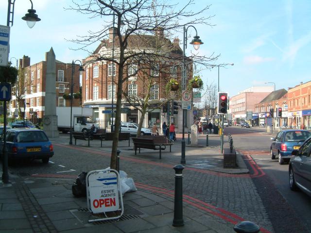
East Sheen. Junction of A205 (Upper
Richmond Road) and B351 (Sheen Lane). Notice the War Memorial (on the left) and the old milestone (in the centre, next to the traffic lights) on a piece of land called the
43:
908:== {{int:filedesc}} == {{Information |description={{en|1=East Sheen. Junction of A205 (Upper Richmond Road) and B351 (Sheen Lane)}} |date=2003-04-11 |source=From |author=[http://www.geograph.org.uk/pr
83:
51:
681:
645:
609:
490:
473:
275:
701:
310:
1003:
This file contains additional information, probably added from the digital camera or scanner used to create or digitize it.
400:
836:
544:
820:
786:
724:
665:
593:
565:
552:
537:
752:
709:
694:
629:
510:
457:
297:
356:
1006:
If the file has been modified from its original state, some details may not fully reflect the modified file.
918:
The following pages on the
English Knowledge (XXG) use this file (pages on other projects are not listed):
890:
885:
399:– If you remix, transform, or build upon the material, you must distribute your contributions under the
317:
on the
Geograph website for the photographer's contact details. The copyright on this image is owned by
42:
901:
353:
162:
140:
91:
228:
157:
135:
212:
572:
980:
731:
716:
281:
322:
78:
180:
922:
474:
Milestone At
Junction With Sheen Lane (On South Side Beside Public Lavatory)
265:
302:
201:
191:
858:
Click on a date/time to view the file as it appeared at that time.
314:
267:
250:
66:
779:
970:
260:
51° 27′ 51″ N, 0° 15′ 58″ W
960:
950:
940:
441:
Add a one-line explanation of what this file represents
990:
151:
129:
110:
90:
Commons is a freely licensed media file repository.
646:
Creative
Commons Attribution-ShareAlike 2.0 Generic
56:(640 × 480 pixels, file size: 62 KB, MIME type:
410:https://creativecommons.org/licenses/by-sa/2.0
71:
416:Creative Commons Attribution-Share Alike 2.0
334:
8:
376:– to copy, distribute and transmit the work
1008:
860:
437:
933:The following other wikis use this file:
1010:
920:
834:
818:
800:
784:
766:
750:
679:
663:
643:
627:
607:
591:
524:
508:
488:
471:
455:
452:
433:
426:
253:
837:London Borough of Richmond upon Thames
573:https://www.geograph.org.uk/profile/82
274:View this and other nearby images on:
116:East Sheen - geograph.org.uk - 730.jpg
52:East_Sheen_-_geograph.org.uk_-_730.jpg
717:https://www.geograph.org.uk/photo/730
7:
491:Mortlake and East Sheen War Memorial
321:and is licensed for reuse under the
849:
357:Attribution-Share Alike 2.0 Generic
345:
340:
325:Attribution-ShareAlike 2.0 license.
1001:
446:
440:
331:
308:
155:
133:
120:
103:
49:
445:
431:
387:Under the following conditions:
352:This file is licensed under the
344:
339:
333:
301:
280:
266:
70:
31:
21:
428:
121:
46:No higher resolution available.
14:
682:file available on the internet
427:
309:This image was taken from the
26:
1:
787:coordinates of depicted place
36:
702:Geograph Britain and Ireland
538:object of statement has role
453:Items portrayed in this file
241:Richard Howell /
222:Richard Howell /
1032:
987:Usage on www.wikidata.org
977:Usage on ur.wikipedia.org
967:Usage on no.wikipedia.org
957:Usage on fr.wikipedia.org
947:Usage on eu.wikipedia.org
937:Usage on es.wikipedia.org
401:same or compatible license
850:
802:51°27'51.5"N, 0°15'57.6"W
16:
725:geograph.org.uk image ID
430:
367:
77:This is a file from the
907:
213:required by the license
197:
186:
179:
176:
113:
81:. Information from its
886:01:18, 30 January 2010
315:this photograph's page
286:51.464300; -0.266000
84:description page there
821:location of creation
382:– to adapt the work
156:This is a photo of
134:This is a photo of
553:author name string
1019:
1018:
929:Global file usage
911:
630:copyright license
439:
330:
329:
313:collection. See
291:
290:
248:
247:
216:
172:
171:
150:
149:
99:
98:
79:Wikimedia Commons
32:Global file usage
1023:
1009:
898:
734:
729:
719:
714:
710:described at URL
704:
699:
594:copyright status
575:
570:
560:
557:
547:
542:
423:
420:
417:
414:
411:
403:as the original.
365:
354:Creative Commons
348:
347:
343:
342:
337:
336:
323:Creative Commons
311:Geograph project
305:
298:
287:
284:
270:
269:
263:
262:
251:
210:
182:
165:
152:
143:
130:
125:
117:
111:
95:
74:
73:
67:
61:
59:
1031:
1030:
1026:
1025:
1024:
1022:
1021:
1020:
997:
927:
919:
912:
904:
896:
852:
851:
848:
847:
846:
845:
844:
843:
842:
841:
839:
827:
826:
825:
823:
812:
811:
810:
809:
808:
807:
806:
805:
803:
793:
792:
791:
789:
778:
777:
776:
775:
774:
773:
772:
771:
769:
759:
758:
757:
755:
744:
743:
742:
741:
740:
739:
738:
737:
736:
735:
730:
727:
721:
720:
715:
712:
706:
705:
700:
697:
688:
687:
686:
684:
672:
671:
670:
668:
657:
656:
655:
654:
653:
652:
651:
650:
648:
636:
635:
634:
632:
621:
620:
619:
618:
617:
616:
615:
614:
612:
600:
599:
598:
596:
585:
584:
583:
582:
581:
580:
579:
578:
577:
576:
571:
568:
562:
561:
558:
555:
549:
548:
543:
540:
531:
530:
529:
527:
517:
516:
515:
513:
502:
501:
500:
499:
498:
497:
496:
495:
493:
482:
481:
480:
479:
478:
476:
464:
463:
462:
460:
444:
443:
442:
425:
424:
421:
418:
415:
412:
409:
408:
366:
363:
360:
349:
326:
296:
285:
258:
257:
254:Object location
249:
238:
231:
219:
192:geograph.org.uk
167:
161:
158:listed building
145:
139:
136:listed building
128:
115:
108:
101:
100:
89:
88:
87:is shown below.
63:
57:
55:
48:
47:
12:
11:
5:
1029:
1027:
1017:
1016:
1013:
1000:
996:
995:
994:
993:
985:
984:
983:
975:
974:
973:
971:Sheen (London)
965:
964:
963:
955:
954:
953:
945:
944:
943:
931:
930:
926:
925:
917:
916:
915:
910:
909:
906:
902:
899:
893:
888:
883:
879:
878:
875:
872:
869:
866:
863:
856:
855:
840:
835:
833:
832:
831:
830:
829:
828:
824:
819:
817:
816:
815:
814:
813:
804:
801:
799:
798:
797:
796:
795:
794:
790:
785:
783:
782:
781:
780:
770:
767:
765:
764:
763:
762:
761:
760:
756:
751:
749:
748:
747:
746:
745:
723:
722:
708:
707:
693:
692:
691:
690:
689:
685:
680:
678:
677:
676:
675:
674:
673:
669:
666:source of file
664:
662:
661:
660:
659:
658:
649:
644:
642:
641:
640:
639:
638:
637:
633:
628:
626:
625:
624:
623:
622:
613:
608:
606:
605:
604:
603:
602:
601:
597:
592:
590:
589:
588:
587:
586:
564:
563:
559:Richard Howell
551:
550:
536:
535:
534:
533:
532:
528:
525:
523:
522:
521:
520:
519:
518:
514:
509:
507:
506:
505:
504:
503:
494:
489:
487:
486:
485:
484:
483:
477:
472:
470:
469:
468:
467:
466:
465:
461:
456:
454:
451:
450:
449:
448:
447:
436:
435:
432:
429:
407:
406:
405:
404:
394:
385:
384:
383:
377:
370:You are free:
364:Richard Howell
361:
351:
350:
332:
328:
327:
319:Richard Howell
306:
295:
292:
289:
288:
278:
272:
255:
246:
245:
239:
236:
233:
232:
227:
220:
217:
205:
204:
202:Richard Howell
199:
195:
194:
188:
184:
183:
178:
174:
173:
170:
169:
148:
147:
118:
109:
107:
104:
102:
97:
96:
75:
65:
64:
45:
41:
40:
39:
34:
29:
24:
19:
13:
10:
9:
6:
4:
3:
2:
1028:
1014:
1011:
1007:
1004:
998:
992:
989:
988:
986:
982:
979:
978:
976:
972:
969:
968:
966:
962:
959:
958:
956:
952:
949:
948:
946:
942:
939:
938:
936:
935:
934:
928:
924:
921:
913:
905:
900:
894:
892:
889:
887:
884:
881:
880:
876:
873:
870:
867:
864:
862:
861:
859:
853:
838:
822:
788:
768:11 April 2003
754:
733:
726:
718:
711:
703:
696:
683:
667:
647:
631:
611:
595:
574:
567:
554:
546:
539:
512:
492:
475:
459:
413:CC BY-SA 2.0
402:
398:
395:
392:
389:
388:
386:
381:
378:
375:
372:
371:
369:
368:
362:Attribution:
358:
355:
338:
324:
320:
316:
312:
307:
304:
300:
299:
293:
283:
279:
277:
276:OpenStreetMap
273:
271:
261:
256:
252:
244:
240:
235:
234:
230:
226: /
225:
221:
214:
209:
207:
206:
203:
200:
196:
193:
189:
185:
181:11 April 2003
175:
168:
164:
159:
154:
153:
146:
142:
137:
132:
131:
124:
119:
112:
105:
93:
86:
85:
80:
76:
69:
68:
62:
53:
44:
38:
35:
33:
30:
28:
25:
23:
20:
18:
15:
1005:
1002:
932:
857:
854:File history
545:photographer
396:
390:
379:
373:
318:
242:
229:CC BY-SA 2.0
223:
122:
92:You can help
82:
50:
22:File history
903:GeographBot
610:copyrighted
397:share alike
391:attribution
208:Attribution
114:Description
1012:_error
961:East Sheen
951:East Sheen
941:East Sheen
923:East Sheen
914:File usage
895:640 × 480
871:Dimensions
526:some value
243:East Sheen
224:East Sheen
58:image/jpeg
27:File usage
868:Thumbnail
865:Date/Time
753:inception
294:Licensing
237:InfoField
218:InfoField
127:Triangle.
123:English:
999:Metadata
991:Q2530557
981:ایسٹ شین
695:operator
434:Captions
380:to remix
374:to share
359:license.
37:Metadata
897:(62 KB)
882:current
877:Comment
511:creator
458:depicts
438:English
163:1445722
160:number
141:1253072
138:number
106:Summary
54:
264:
198:Author
187:Source
190:From
874:User
422:true
419:true
177:Date
17:File
732:730
566:URL
728::
713::
698::
569::
556::
541::
1015:0
215:)
211:(
166:.
144:.
94:.
60:)
Text is available under the Creative Commons Attribution-ShareAlike License. Additional terms may apply.
_&language=en)
