365:
298:
248:
290:
240:
312:
262:
333:
371:
376:
67:
860:"}},"text\/plain":{"en":{"":"heading"}}},"{\"value\":{\"amount\":\"+337\",\"unit\":\"http:\\\/\\\/www.wikidata.org\\\/entity\\\/Q28390\"},\"type\":\"quantity\"}":{"text\/html":{"en":{"P7787":"337
796:"}},"text\/plain":{"en":{"":"heading"}}},"{\"value\":{\"amount\":\"+337\",\"unit\":\"http:\\\/\\\/www.wikidata.org\\\/entity\\\/Q28390\"},\"type\":\"quantity\"}":{"text\/html":{"en":{"P7787":"337
792:
281:
231:
38:
423:– You must give appropriate credit, provide a link to the license, and indicate if changes were made. You may do so in any reasonable manner, but not in any way that suggests the licensor endorses you or your use.
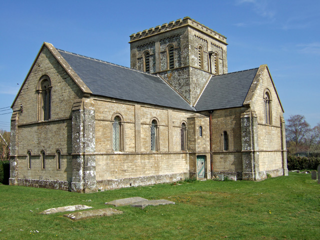
1157:== {{int:filedesc}} == {{Information |description={{en|1=East Stour Church The Neo-Norman church of Christ Church at East Stour, was built in 1842}} |date=2007-04-05 |source=From |author=[http://ww
78:
46:
857:
793:
1288:
694:
658:
622:
503:
305:
255:
943:
729:
1319:
340:
1182:
This file contains additional information, probably added from the digital camera or scanner used to create or digitize it.
430:
585:
1068:
1034:
997:
963:
927:
898:
871:
834:
807:
737:
678:
606:
578:
565:
550:
765:
722:
707:
642:
523:
487:
1139:
1134:
327:
37:
1171:
386:
1185:
If the file has been modified from its original state, some details may not fully reflect the modified file.
1372:
429:– If you remix, transform, or build upon the material, you must distribute your contributions under the
347:
on the
Geograph website for the photographer's contact details. The copyright on this image is owned by
1150:
383:
110:
864:"}},"text\/plain":{"en":{"P7787":"337 degree"}}}}": -->
800:"}},"text\/plain":{"en":{"P7787":"337 degree"}}}}": -->
1408:
86:
200:
105:
557:
744:
714:
184:
311:
261:
1476:
1390:
1346:
1211:
352:
73:
1251:
1418:
1204:
245:
152:
1231:
295:
173:
163:
1494:
1221:
1194:
332:
143:
Christ Church parish church, East Stour, Dorset, seen from the southwest
344:
1107:
Click on a date/time to view the file as it appeared at that time.
297:
247:
272:
222:
61:
282:
51° 00′ 16″ N, 2° 17′ 19″ W
232:
51° 00′ 16″ N, 2° 17′ 18″ W
471:
Add a one-line explanation of what this file represents
127:
99:
85:
Commons is a freely licensed media file repository.
659:
Creative
Commons Attribution-ShareAlike 2.0 Generic
51:(640 × 480 pixels, file size: 176 KB, MIME type:
1413:Flash did not fire, compulsory flash suppression
133:East Stour Church - geograph.org.uk - 390796.jpg
47:East_Stour_Church_-_geograph.org.uk_-_390796.jpg
440:https://creativecommons.org/licenses/by-sa/2.0
66:
446:Creative Commons Attribution-Share Alike 2.0
364:
8:
861:
797:
406:– to copy, distribute and transmit the work
1187:
1109:
467:
558:https://www.geograph.org.uk/profile/10423
715:https://www.geograph.org.uk/photo/390796
1502:
1492:
1484:
1474:
1466:
1458:
1450:
1442:
1434:
1426:
1416:
1406:
1398:
1388:
1380:
1370:
1362:
1354:
1344:
1336:
1328:
1317:
1309:
1301:
1293:
1283:
1275:
1267:
1259:
1248:
1240:
1229:
1219:
1209:
1199:
1169:
1082:
1066:
1048:
1032:
1011:
995:
977:
961:
941:
925:
885:
869:
821:
805:
779:
763:
692:
676:
656:
640:
620:
604:
537:
521:
501:
485:
482:
463:
456:
275:
225:
304:View this and other nearby images on:
254:View this and other nearby images on:
1189:
7:
1289:Adobe Photoshop Elements 3.0 Windows
351:and is licensed for reuse under the
1167:The following page uses this file:
1098:
387:Attribution-Share Alike 2.0 Generic
375:
370:
355:Attribution-ShareAlike 2.0 license.
1180:
476:
470:
361:
338:
137:
103:
98:
44:
475:
1242:Date and time of data generation
808:coordinates of the point of view
461:
417:Under the following conditions:
382:This file is licensed under the
374:
369:
363:
331:
310:
296:
288:
260:
246:
238:
65:
21:
458:
138:
41:No higher resolution available.
14:
1216:1/420 sec (0.0023809523809524)
695:file available on the internet
457:
339:This image was taken from the
26:
1:
872:coordinates of depicted place
31:
823:51°0'16.024"N, 2°17'18.312"W
730:Geograph Britain and Ireland
579:object of statement has role
483:Items portrayed in this file
287:
237:
1444:Focal plane resolution unit
1330:Date and time of digitizing
1524:
1455:One-chip color area sensor
887:51°0'16.38"N, 2°17'18.60"W
431:same or compatible license
1295:File change date and time
1172:Christ Church, East Stour
1099:
16:
1436:Focal plane Y resolution
1428:Focal plane X resolution
738:geograph.org.uk image ID
460:
397:
213:Mike Searle /
194:Mike Searle /
72:This is a file from the
1460:Custom image processing
1156:
185:required by the license
169:
158:
151:
148:
130:
76:. Information from its
1504:Subject distance range
1338:Image compression mode
1135:17:33, 3 February 2011
345:this photograph's page
316:51.004550; -2.288500
266:51.004451; -2.288420
79:description page there
1382:Maximum land aperture
1269:Horizontal resolution
928:location of creation
1333:11:24, 5 April 2007
1303:Y and C positioning
1298:22:15, 5 April 2007
1277:Vertical resolution
1245:11:24, 5 April 2007
1191:Camera manufacturer
1013:0.0023809523809524
412:– to adapt the work
104:This is a photo of
1486:Scene capture type
1481:Auto white balance
566:author name string
1511:
1510:
1160:
863:
799:
643:copyright license
469:
360:
359:
343:collection. See
321:
320:
271:
270:
220:
219:
215:East Stour Church
196:East Stour Church
188:
120:
119:
94:
93:
74:Wikimedia Commons
1515:
1311:Exposure Program
1188:
1147:
1087:
1016:
909:
908:
903:
845:
844:
839:
747:
742:
732:
727:
717:
712:
708:described at URL
607:copyright status
588:
583:
573:
570:
560:
555:
453:
450:
447:
444:
441:
433:as the original.
395:
384:Creative Commons
378:
377:
373:
372:
367:
366:
353:Creative Commons
341:Geograph project
335:
328:
317:
314:
300:
299:
293:
292:
291:
285:
284:
273:
267:
264:
250:
249:
243:
242:
241:
235:
234:
223:
182:
154:
142:
134:
128:
113:
100:
90:
69:
68:
62:
56:
54:
1523:
1522:
1518:
1517:
1516:
1514:
1513:
1512:
1385:3 APEX (f/2.83)
1364:APEX brightness
1205:FinePix F10
1176:
1161:
1153:
1145:
1101:
1100:
1097:
1096:
1095:
1094:
1093:
1092:
1091:
1090:
1088:
1085:
1075:
1074:
1073:
1071:
1060:
1059:
1058:
1057:
1056:
1055:
1054:
1053:
1051:
1041:
1040:
1039:
1037:
1026:
1025:
1024:
1023:
1022:
1021:
1020:
1019:
1017:
1014:
1004:
1003:
1002:
1000:
989:
988:
987:
986:
985:
984:
983:
982:
980:
970:
969:
968:
966:
955:
954:
953:
952:
951:
950:
949:
948:
946:
934:
933:
932:
930:
919:
918:
917:
916:
915:
914:
913:
912:
911:
910:
906:
904:
901:
892:
891:
890:
888:
878:
877:
876:
874:
855:
854:
853:
852:
851:
850:
849:
848:
847:
846:
842:
840:
837:
828:
827:
826:
824:
814:
813:
812:
810:
791:
790:
789:
788:
787:
786:
785:
784:
782:
772:
771:
770:
768:
757:
756:
755:
754:
753:
752:
751:
750:
749:
748:
743:
740:
734:
733:
728:
725:
719:
718:
713:
710:
701:
700:
699:
697:
685:
684:
683:
681:
670:
669:
668:
667:
666:
665:
664:
663:
661:
649:
648:
647:
645:
634:
633:
632:
631:
630:
629:
628:
627:
625:
613:
612:
611:
609:
598:
597:
596:
595:
594:
593:
592:
591:
590:
589:
584:
581:
575:
574:
571:
568:
562:
561:
556:
553:
544:
543:
542:
540:
530:
529:
528:
526:
515:
514:
513:
512:
511:
510:
509:
508:
506:
494:
493:
492:
490:
474:
473:
472:
455:
454:
451:
448:
445:
442:
439:
438:
396:
393:
390:
379:
356:
326:
315:
289:
280:
279:
276:Object location
265:
239:
230:
229:
226:Camera location
221:
210:
203:
191:
164:geograph.org.uk
144:
132:
125:
115:
109:
106:listed building
96:
95:
84:
83:
82:is shown below.
58:
52:
50:
43:
42:
12:
11:
5:
1521:
1519:
1509:
1508:
1505:
1501:
1500:
1497:
1491:
1490:
1487:
1483:
1482:
1479:
1473:
1472:
1469:
1465:
1464:
1463:Normal process
1461:
1457:
1456:
1453:
1452:Sensing method
1449:
1448:
1445:
1441:
1440:
1437:
1433:
1432:
1429:
1425:
1424:
1421:
1415:
1414:
1411:
1405:
1404:
1401:
1397:
1396:
1393:
1387:
1386:
1383:
1379:
1378:
1375:
1369:
1368:
1365:
1361:
1360:
1357:
1353:
1352:
1349:
1343:
1342:
1339:
1335:
1334:
1331:
1327:
1326:
1323:
1316:
1315:
1314:Normal program
1312:
1308:
1307:
1304:
1300:
1299:
1296:
1292:
1291:
1286:
1282:
1281:
1278:
1274:
1273:
1270:
1266:
1265:
1262:
1258:
1257:
1254:
1247:
1246:
1243:
1239:
1238:
1235:
1228:
1227:
1224:
1218:
1217:
1214:
1208:
1207:
1202:
1198:
1197:
1192:
1179:
1175:
1174:
1165:
1164:
1159:
1158:
1155:
1151:
1148:
1142:
1137:
1132:
1128:
1127:
1124:
1121:
1118:
1115:
1112:
1105:
1104:
1089:
1083:
1081:
1080:
1079:
1078:
1077:
1076:
1072:
1067:
1065:
1064:
1063:
1062:
1061:
1052:
1049:
1047:
1046:
1045:
1044:
1043:
1042:
1038:
1033:
1031:
1030:
1029:
1028:
1027:
1018:
1012:
1010:
1009:
1008:
1007:
1006:
1005:
1001:
996:
994:
993:
992:
991:
990:
981:
978:
976:
975:
974:
973:
972:
971:
967:
962:
960:
959:
958:
957:
956:
947:
942:
940:
939:
938:
937:
936:
935:
931:
926:
924:
923:
922:
921:
920:
897:
896:
895:
894:
893:
889:
886:
884:
883:
882:
881:
880:
879:
875:
870:
868:
867:
866:
865:
859:
833:
832:
831:
830:
829:
825:
822:
820:
819:
818:
817:
816:
815:
811:
806:
804:
803:
802:
801:
795:
783:
780:
778:
777:
776:
775:
774:
773:
769:
764:
762:
761:
760:
759:
758:
736:
735:
721:
720:
706:
705:
704:
703:
702:
698:
693:
691:
690:
689:
688:
687:
686:
682:
679:source of file
677:
675:
674:
673:
672:
671:
662:
657:
655:
654:
653:
652:
651:
650:
646:
641:
639:
638:
637:
636:
635:
626:
621:
619:
618:
617:
616:
615:
614:
610:
605:
603:
602:
601:
600:
599:
577:
576:
564:
563:
549:
548:
547:
546:
545:
541:
538:
536:
535:
534:
533:
532:
531:
527:
522:
520:
519:
518:
517:
516:
507:
502:
500:
499:
498:
497:
496:
495:
491:
486:
484:
481:
480:
479:
478:
477:
466:
465:
462:
459:
437:
436:
435:
434:
424:
415:
414:
413:
407:
400:You are free:
391:
381:
380:
362:
358:
357:
336:
325:
322:
319:
318:
308:
302:
277:
269:
268:
258:
252:
227:
218:
217:
211:
208:
205:
204:
199:
192:
189:
177:
176:
171:
167:
166:
160:
156:
155:
150:
146:
145:
135:
126:
124:
121:
118:
117:
97:
92:
91:
70:
60:
59:
40:
36:
35:
34:
29:
24:
19:
13:
10:
9:
6:
4:
3:
2:
1520:
1506:
1503:
1498:
1496:
1493:
1488:
1485:
1480:
1478:
1477:White balance
1475:
1471:Auto exposure
1470:
1468:Exposure mode
1467:
1462:
1459:
1454:
1451:
1446:
1443:
1438:
1435:
1430:
1427:
1422:
1420:
1417:
1412:
1410:
1407:
1402:
1399:
1394:
1392:
1391:Metering mode
1389:
1384:
1381:
1376:
1374:
1373:Exposure bias
1371:
1366:
1363:
1358:
1356:APEX aperture
1355:
1350:
1348:
1347:Shutter speed
1345:
1340:
1337:
1332:
1329:
1324:
1321:
1318:
1313:
1310:
1305:
1302:
1297:
1294:
1290:
1287:
1285:Software used
1284:
1279:
1276:
1271:
1268:
1263:
1260:
1255:
1253:
1249:
1244:
1241:
1236:
1233:
1230:
1225:
1223:
1220:
1215:
1213:
1212:Exposure time
1210:
1206:
1203:
1200:
1196:
1193:
1190:
1186:
1183:
1177:
1173:
1170:
1168:
1162:
1154:
1149:
1143:
1141:
1138:
1136:
1133:
1130:
1129:
1125:
1122:
1119:
1116:
1113:
1111:
1110:
1108:
1102:
1070:
1036:
999:
998:exposure time
965:
945:
929:
900:
873:
836:
809:
767:
746:
739:
731:
724:
716:
709:
696:
680:
660:
644:
624:
608:
587:
580:
567:
559:
552:
525:
505:
504:Christ Church
489:
443:CC BY-SA 2.0
432:
428:
425:
422:
419:
418:
416:
411:
408:
405:
402:
401:
399:
398:
392:Attribution:
388:
385:
368:
354:
350:
346:
342:
337:
334:
330:
329:
323:
313:
309:
307:
306:OpenStreetMap
303:
301:
283:
278:
274:
263:
259:
257:
256:OpenStreetMap
253:
251:
233:
228:
224:
216:
212:
207:
206:
202:
198: /
197:
193:
186:
181:
179:
178:
175:
172:
168:
165:
161:
157:
147:
141:
136:
129:
122:
116:
112:
107:
102:
101:
88:
81:
80:
75:
71:
64:
63:
57:
48:
39:
33:
30:
28:
25:
23:
20:
18:
15:
1400:Light source
1252:focal length
1201:Camera model
1184:
1181:
1166:
1106:
1103:File history
1069:focal length
781:5 April 2007
586:photographer
426:
420:
409:
403:
348:
286:
236:
214:
201:CC BY-SA 2.0
195:
153:5 April 2007
139:
87:You can help
77:
45:
22:File history
1419:Color space
1261:Orientation
1152:GeographBot
623:copyrighted
572:Mike Searle
427:share alike
421:attribution
394:Mike Searle
349:Mike Searle
180:Attribution
174:Mike Searle
131:Description
1163:File usage
1144:640 × 480
1120:Dimensions
1086:millimetre
944:East Stour
539:some value
53:image/jpeg
27:File usage
1495:Sharpness
1232:ISO speed
1117:Thumbnail
1114:Date/Time
964:ISO speed
766:inception
324:Licensing
209:InfoField
190:InfoField
140:English:
1489:Standard
1306:Co-sited
1222:F-number
1195:FUJIFILM
1178:Metadata
1146:(176 KB)
1035:f-number
723:operator
464:Captions
410:to remix
404:to share
389:license.
32:Metadata
1507:Unknown
1403:Unknown
1395:Pattern
1322:version
1131:current
1126:Comment
899:heading
858:heading
835:heading
794:heading
524:creator
488:depicts
468:English
123:Summary
111:1110455
108:number
49:
1499:Normal
1280:72 dpi
1272:72 dpi
1264:Normal
1234:rating
1015:second
907:degree
862:degree
843:degree
798:degree
745:390796
294:
244:
170:Author
159:Source
1439:3,703
1431:3,703
1409:Flash
1367:10.15
1250:Lens
162:From
1423:sRGB
1320:Exif
1256:8 mm
1123:User
905:337
841:337
452:true
449:true
149:Date
17:File
1359:4.6
1351:8.7
1325:2.2
1226:f/5
551:URL
1237:80
1084:8
979:80
902::
838::
741::
726::
711::
582::
569::
554::
1447:3
1377:0
1341:4
1050:5
187:)
183:(
114:.
89:.
55:)
Text is available under the Creative Commons Attribution-ShareAlike License. Additional terms may apply.
_heading:337.00&language=en)
_heading:337.00&language=en)
