43:
277:
300:
242:
264:
387:
306:
400:
311:
99:
737:
707:
153:
The
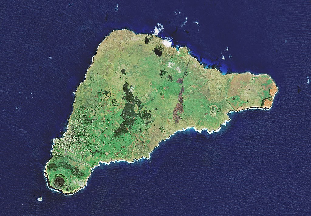
Copernicus Sentinel-2 mission takes us over one of the most remote islands in the world: Easter Island. Located in the Pacific Ocean, over 3500 km off the west coast of South America, this Chilean island is also known as Rapa Nui by its original inhabitants. The island was given its current name
160:
An interesting feature of the image is the ochre-orange colour of the Poike – the peninsula on the eastern end of the island. In ancient times, it is said that there was a lot of vegetation on the island. However, land clearing for cultivation and the
Polynesian rat played a role in deforestation,
156:
The island is famous for its monolithic stone statues, called Moai, said to honour the memory of the inhabitants’ ancestors. There are nearly 1000 scattered around the island, usually positioned near freshwater. Many are located near the Rano Raraku volcano, on the southeast coast. The white edges
176:
Many tourists are drawn to the island for its mysterious history and isolated position. What is relatively unknown is the existence of two small beaches on the northeast coast. Anakena beach has white, coral sand, while the smaller Ovahe beach, surrounded by cliffs, has pink sand.
168:
The majority of the island’s inhabitants live in Hanga Roa, the main town and harbour on the west coast, clearly visible in the image. Interestingly, the long runway of the island’s only airport was once designated as an emergency landing site for the US space shuttle.
164:
Several reforestation projects have been attempted, including a eucalyptus plantation in the middle of the island, visible in dark green. The brown patch to the right of the plantation is likely to be a burn scar from a wildfire.
180:
Copernicus
Sentinel-2 is a two-satellite mission. Each satellite carries a high-resolution camera that images Earth’s surface in 13 spectral bands. Data from Copernicus Sentinel-2 can help monitor changes in land cover.
352:– You must give appropriate credit, provide a link to the license, and indicate if changes were made. You may do so in any reasonable manner, but not in any way that suggests the licensor endorses you or your use.
172:
At the very edge of the southwest tip of the island lies Ranu Kao, the largest volcano on the island. Its shape is distinctive owing to its crater lake, one of the island’s only three natural bodies of water.
65:
61:
57:
53:
47:
78:
505:
GMES dedicated data and GMES service information are provided to users without any express or implied warranty, including as regards quality and suitability for any purpose.
110:
790:
736:
731:
490:
When distributing or communicating GMES dedicated data to the public, users shall inform the public of the source of that data and information.
221:
785:
754:
493:
Users shall make sure not to convey the impression to the public that the user’s activities are officially endorsed by the Union.
618:
582:
856:
This file contains additional information, probably added from the digital camera or scanner used to create or digitize it.
359:
706:
701:
566:
69:
42:
638:
602:
549:
321:
255:
780:
459:
Access to GMES dedicated data shall be given for the purpose of the following use in so far as it is lawful:
859:
If the file has been modified from its original state, some details may not fully reflect the modified file.
771:
The following pages on the
English Knowledge (XXG) use this file (pages on other projects are not listed):
451:
Free access shall be given to GMES dedicated data made available through GMES dissemination platforms .
183:
This image, which was captured on 7 April 2019, is also featured on the Earth from Space video programme.
358:– If you remix, transform, or build upon the material, you must distribute your contributions under the
406:
439:
435:
876:
318:
263:
276:
118:
202:
496:
Where that data or information has been adapted or modified, the user shall clearly state this.
747:
717:
775:
228:
contains modified
Copernicus Sentinel data (2019), processed by ESA, CC BY-SA 3.0 IGO
105:
758:
843:
418:
414:
410:
838:
192:
394:
473:
adaptation, modification and combination with other data and information;
241:
481:
GMES dedicated data may be used worldwide without limitations in time.
157:
along the southern coast show the harsh waves colliding with the shore.
674:
Click on a date/time to view the file as it appeared at that time.
434:
The use of
Copernicus Sentinel Data is regulated under EU law (
161:
leading to the erosion of the soil, particularly in the east.
93:
203:
http://www.esa.int/spaceinimages/Images/2019/04/Easter_Island
385:
818:
154:
the day
Europeans arrived in the 1700s – on Easter Sunday.
369:
https://creativecommons.org/licenses/by-sa/3.0/igo/deed.en
828:
808:
533:
Add a one-line explanation of what this file represents
83:(2,946 × 2,042 pixels, file size: 1.75 MB, MIME type:
485:
Conditions regarding information to be given by users
426:
Contains modified
Copernicus Sentinel data {{{year}}}
236:
137:
117:
Commons is a freely licensed media file repository.
436:Commission Delegated Regulation (EU) No 1159/2013
421:. Attribution is required when using this image.
405:This image contains data from a satellite in the
375:Creative Commons Attribution-Share Alike 3.0 igo
143:Easter Island ESA419941 (cropped, lightened).jpg
619:Creative Commons Attribution-ShareAlike 3.0 IGO
98:
299:
8:
335:– to copy, distribute and transmit the work
861:
676:
529:
801:The following other wikis use this file:
897:
889:
881:
871:
863:
791:User:Iamojo/testcase/EasterIsland short
773:
652:
636:
616:
600:
580:
564:
547:
544:
525:
518:
272:
476:any combination of points (a) to (d).
7:
665:
310:
305:
854:
538:
532:
296:
247:
147:
130:
76:
786:User:Iamojo/testcase/EasterIsland
537:
757:cropped 19 % horizontally using
755:File:Easter Island ESA419941.jpg
523:
398:
346:Under the following conditions:
317:This file is licensed under the
309:
304:
298:
275:
262:
240:
97:
31:
21:
520:
148:
14:
519:
322:Attribution-ShareAlike 3.0 IGO
26:
1:
36:
545:Items portrayed in this file
470:communication to the public;
440:Regulation (EU) No 377/2014
256:Easter Island ESA419941.jpg
919:
835:Usage on vi.wikipedia.org
825:Usage on nl.wikipedia.org
815:Usage on es.wikipedia.org
805:Usage on de.wikipedia.org
781:Geography of Easter Island
360:same or compatible license
666:
399:
16:
522:
455:Conditions regarding use
326:
104:This is a file from the
753:
723:
232:
216:
208:
198:
191:
188:
140:
108:. Information from its
442:). Relevant excerpts:
390:
111:description page there
46:Size of this preview:
844:Thành viên:Cnykr/Nháp
389:
212:European Space Agency
732:16:51, 23 April 2019
702:16:53, 23 April 2019
447:Financial conditions
407:Copernicus Programme
70:2,946 × 2,042 pixels
761:with lossless mode.
724:Lightened up colors
501:Absence of warranty
341:– to adapt the work
248:This file has been
52:Other resolutions:
391:
66:1,280 × 887 pixels
62:1,024 × 710 pixels
906:
905:
797:Global file usage
764:
603:copyright license
531:
512:
511:
289:
288:
271:
270:
252:from another file
225:
222:Reusing this file
126:
125:
106:Wikimedia Commons
32:Global file usage
910:
862:
744:
714:
567:copyright status
516:
431:
427:
402:
401:
395:
388:
382:
379:
376:
373:
372:CC BY-SA 3.0 igo
370:
362:as the original.
319:Creative Commons
313:
312:
308:
307:
302:
301:
279:
266:
244:
237:
219:
194:
152:
144:
138:
122:
101:
100:
94:
88:
86:
73:
58:640 × 444 pixels
54:320 × 222 pixels
48:800 × 555 pixels
918:
917:
913:
912:
911:
909:
908:
907:
877:Shotwell 0.28.4
850:
795:
772:
765:
750:
742:
720:
712:
668:
667:
664:
663:
662:
661:
660:
659:
658:
657:
655:
645:
644:
643:
641:
630:
629:
628:
627:
626:
625:
624:
623:
621:
609:
608:
607:
605:
594:
593:
592:
591:
590:
589:
588:
587:
585:
573:
572:
571:
569:
558:
557:
556:
555:
554:
552:
536:
535:
534:
514:
479:
432:
429:
425:
393:
392:
386:
383:
380:
377:
374:
371:
368:
367:
325:
314:
295:
290:
283:
280:
267:
253:
184:
142:
135:
128:
127:
116:
115:
114:is shown below.
90:
84:
82:
75:
74:
51:
12:
11:
5:
916:
914:
904:
903:
900:
896:
895:
892:
888:
887:
884:
880:
879:
874:
870:
869:
866:
853:
849:
848:
847:
846:
841:
833:
832:
831:
823:
822:
821:
819:Isla de Pascua
813:
812:
811:
799:
798:
794:
793:
788:
783:
778:
770:
769:
768:
763:
762:
752:
748:
745:
741:2,946 × 2,042
739:
734:
729:
726:
725:
722:
718:
715:
711:2,946 × 2,042
709:
704:
699:
695:
694:
691:
688:
685:
682:
679:
672:
671:
656:
653:
651:
650:
649:
648:
647:
646:
642:
637:
635:
634:
633:
632:
631:
622:
617:
615:
614:
613:
612:
611:
610:
606:
601:
599:
598:
597:
596:
595:
586:
581:
579:
578:
577:
576:
575:
574:
570:
565:
563:
562:
561:
560:
559:
553:
548:
546:
543:
542:
541:
540:
539:
528:
527:
524:
521:
510:
509:
507:
503:
502:
498:
497:
494:
491:
487:
486:
478:
477:
474:
471:
468:
465:
461:
457:
456:
449:
448:
422:
403:
384:
366:
365:
364:
363:
353:
344:
343:
342:
336:
329:You are free:
316:
315:
297:
294:
291:
287:
286:
285:
284:
281:
274:
269:
268:
261:
259:
245:
234:
233:Other versions
230:
229:
226:
214:
213:
210:
206:
205:
200:
196:
195:
190:
186:
185:
145:
136:
134:
131:
129:
124:
123:
102:
92:
91:
45:
41:
40:
39:
34:
29:
24:
19:
13:
10:
9:
6:
4:
3:
2:
915:
901:
898:
893:
890:
885:
882:
878:
875:
873:Software used
872:
867:
864:
860:
857:
851:
845:
842:
840:
839:Đảo Phục Sinh
837:
836:
834:
830:
827:
826:
824:
820:
817:
816:
814:
810:
807:
806:
804:
803:
802:
796:
792:
789:
787:
784:
782:
779:
777:
776:Easter Island
774:
766:
760:
756:
751:
746:
740:
738:
735:
733:
730:
728:
727:
721:
716:
710:
708:
705:
703:
700:
697:
696:
692:
689:
686:
683:
680:
678:
677:
675:
669:
640:
620:
604:
584:
568:
551:
517:
508:
506:
500:
499:
495:
492:
489:
488:
484:
483:
482:
475:
472:
469:
467:distribution;
466:
464:reproduction;
463:
462:
460:
454:
453:
452:
446:
445:
444:
443:
441:
437:
428:
424:Attribution:
420:
416:
412:
408:
404:
397:
396:
361:
357:
354:
351:
348:
347:
345:
340:
337:
334:
331:
330:
328:
327:
323:
320:
303:
292:
278:
273:
265:
260:
258:
257:
251:
246:
243:
239:
238:
235:
231:
227:
223:
218:
215:
211:
207:
204:
201:
197:
187:
182:
178:
174:
170:
166:
162:
158:
151:
146:
139:
132:
120:
113:
112:
107:
103:
96:
95:
89:
80:
79:Original file
71:
67:
63:
59:
55:
49:
44:
38:
35:
33:
30:
28:
25:
23:
20:
18:
15:
891:Image height
858:
855:
800:
673:
670:File history
654:7 April 2019
513:
504:
480:
458:
450:
433:
423:
355:
349:
338:
332:
282:TIFF version
249:
193:7 April 2019
179:
175:
171:
167:
163:
159:
155:
149:
119:You can help
109:
77:
22:File history
883:Image width
865:Orientation
583:copyrighted
515:Attribution
430:Attribution
356:share alike
350:attribution
141:Description
829:Paaseiland
809:Osterinsel
767:File usage
749:Ariadacapo
719:Ariadacapo
687:Dimensions
419:Sentinel-3
415:Sentinel-2
411:Sentinel-1
409:, such as
217:Permission
85:image/jpeg
27:File usage
743:(3.64 MB)
713:(1.75 MB)
684:Thumbnail
681:Date/Time
639:inception
293:Licensing
250:extracted
150:English:
902:2,946 px
894:2,042 px
886:2,946 px
852:Metadata
759:CropTool
526:Captions
339:to remix
333:to share
324:license.
37:Metadata
698:current
693:Comment
550:depicts
530:English
133:Summary
81:
868:Normal
209:Author
199:Source
899:Width
690:User
438:and
381:true
378:true
189:Date
17:File
417:or
413:,
254::
68:|
64:|
60:|
56:|
50:.
224:)
220:(
121:.
87:)
72:.
Text is available under the Creative Commons Attribution-ShareAlike License. Additional terms may apply.

.jpg)

