841:
923:
806:
878:
853:
929:
43:
934:
91:
1433:
1403:
1373:
1343:
1313:
1450:{{Information |Description=Eastern frontier of the Colony of the Cape of Good Hope from Algoa Bay to the Great Kei river *Settled colonial area shown in green, with districts established in 1820 shown in different shades of green *Neutral zone agreed on b
1420:{{Information |Description=Eastern frontier of the Colony of the Cape of Good Hope from Algoa Bay to the Great Kei river *Settled colonial area shown in green, with districts established in 1820 shown in different shades of green *Neutral zone agreed on b
840:
992:– You must give appropriate credit, provide a link to the license, and indicate if changes were made. You may do so in any reasonable manner, but not in any way that suggests the licensor endorses you or your use.
423:
Sixty farmers sought refuge here for two months during the Eighth
Frontier War (1850-1853). Lieutenant-colonel John Fordyce and other casualties of this war were interred in a small military cemetery nearby.
240:
431:
369:
479:
627:
680:
529:
57:
53:
47:
70:
102:
1747:
1637:
1489:
895:
515:
was at first a post for patrols (est. ca 1812) at
Hermanuskraal, named for Khoikhoi chieftain Hermanus Xogomesh, before a fort replaced it during the
730:
was a homeland for displaced Khoi-khoi where they occupied land tenures for the mission stations. They suffered greatly during the 6th
Frontier War.
420:
in 1837. It consists of officers quarters, large stables, stores and additional quarters for soldiers, built around a parade ground of one acre.
1432:
1427:
1402:
1397:
1372:
1367:
1342:
1337:
675:
started as a military camp and mission station and became the base from which Sir Harry Smith controlled the tribal areas. The small village
573:
ranges. The earthen redoubt reinforced with stone protected a quadrangle of strong stone cottages and walls, of which only ruins remain. Sir
825:
1360:
Change map colour east of Great Kei River (based on comments received), as it was never part of
British Caffraria. Other minor changes.
893:; with no Invariant Sections, no Front-Cover Texts, and no Back-Cover Texts. A copy of the license is included in the section entitled
519:. It became a police post in 1873, and a police station is still located beside it. The fort was declared a national monument in 1938.
885:
1742:
1224:
1207:
1190:
1173:
1156:
1139:
1103:
1805:
This file contains additional information, probably added from the digital camera or scanner used to create or digitize it.
1737:
999:
574:
334:
1244:
1087:
890:
1312:
1307:
1123:
1070:
791:
Eastern
Frontier of the Colony of the Cape of Good Hope (and part of Kafirland), From Algoa Bay to the Great Kei River
61:
42:
1707:
795:
M.S. Surveys & Sketches, communicated by Lt. Col. Mitchell late Survr. Genl. of the Colony and Captn. Wm Owen ...
337:(in 1847) annexed the northern section of Victoria, and extended the frontier from Gaika's Hill northwards along the
324:
278:
222:
1682:
1772:
830:
961:
957:
953:
949:
945:
1808:
If the file has been modified from its original state, some details may not fully reflect the modified file.
1474:
520:
1460:
The following pages on the
English Knowledge (XXG) use this file (pages on other projects are not listed):
184:
762:
998:– If you remix, transform, or build upon the material, you must distribute your contributions under the
814:
718:
159:
758:
1469:
941:
611:
342:
1542:
565:, was named after major William Cox, and was a base for patrols into the valleys and ravines of the
1717:
566:
110:
198:
405:, was designed by major Charles Selwyn of the Royal Engineers, and remains almost intact. This
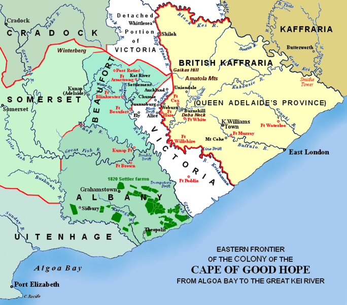
174:(est. 1795), showing Grahamstown (est. 1812), and districts (est. 1820) in shades of pale green
1479:
872:
852:
668:
883:
Permission is granted to copy, distribute and/or modify this document under the terms of the
766:
759:
Eastern frontier of the Colony of the Cape of Good Hope from Algoa Bay to the Great Kei river
616:
346:
338:
320:
667:, a Scottish settlement near the current town, became a transit camp for troops during the
1484:
361:
Most forts remain today as ruins in various degrees of restoration. The most northerly,
570:
207:
188:
153:
1464:
869:
I, the copyright holder of this work, hereby publish it under the following licenses:
417:
410:
97:
413:
225:
203:
170:
516:
468:
316:
819:
421:
1509:
1046:
Eastern frontier of the Cape of Good Hope colony during the early 19th century
217:
696:
682:
643:
629:
545:
531:
495:
481:
447:
433:
385:
371:
256:
242:
1547:
1494:
1647:
1657:
228:
mission (est. 1827): amaTembu living inland and amaXhosa nearer the coast.
1622:
1562:
1443:
1413:
1383:
1353:
1323:
765:’ by G.C.B. Bart, Chapter xlviii, published 1903, as part of the online
1054:
Oosgrens van die Kaap die Goeie Hoop-kolonie tydens die vroeë 19de eeu
1504:
1499:
770:
716:
was est. ca 1832 by settler
Richard Daniel. The farming districts of
1692:
1672:
1280:
Click on a date/time to view the file as it appeared at that time.
577:
was for a time trapped in this fort during the Eighth
Frontier War.
406:
142:
Eastern frontier(s) of the Cape of Good Hope colony, ca 1820 – 1850
1727:
1697:
1652:
1552:
1762:
1667:
1612:
1577:
793:. Arrowsmith's lithograph was redrawn and compiled chiefly from
1592:
471:, built after the 1820 agreement that formed the neutral zone.
800:
85:
1602:
1582:
804:
1662:
619:
missionary centre (est. 1824), and a village formed around
1627:
1532:
210:
faction of amaXhosa and amaTembu under
British protection.
1587:
1174:
Creative
Commons Attribution-ShareAlike 4.0 International
1757:
1597:
1527:
1572:
1543:
Gebruiker:Aliwal2012/Kaart van Oos-Kaap Ciskei Transkei
763:
The autobiography of Lieutenant-general Sir Harry Smith
749:
Based on the source map below, last published in 1903.
1782:
1537:
1208:
Creative Commons Attribution-ShareAlike 3.0 Unported
1191:
GNU Free Documentation License, version 1.2 or later
889:, Version 1.2 or any later version published by the
726:
were also collectively known as the 'Zuurveld'. The
129:
109:
Commons is a freely licensed media file repository.
1792:
1225:
Creative Commons Attribution-ShareAlike 2.0 Generic
1157:
Creative Commons Attribution-ShareAlike 1.0 Generic
1140:
Creative Commons Attribution-ShareAlike 2.5 Generic
757:I created the map, based partly on the source map:
323:up to Gaika's Hill, and thence westwards along the
75:(836 × 733 pixels, file size: 279 KB, MIME type:
135:Eastern Frontier, Cape of Good Hope, ca 1835.png
609:were established in the vicinity of the forts.
1009:https://creativecommons.org/licenses/by-sa/4.0
527:(est. 1835, abandoned 1836-1846, but rebuilt)
333:), marked the eastern frontier of the Colony.
90:
1015:Creative Commons Attribution-Share Alike 4.0
922:
8:
1490:History of the Cape Colony from 1806 to 1870
145:(i.e. period between 5th and 8th Xhosa Wars)
975:– to copy, distribute and transmit the work
786:more or less, and may be John Arrowsmith's
1810:
1282:
1050:
1042:
1027:You may select the license of your choice.
1520:The following other wikis use this file:
1828:
1820:
1812:
1462:
1258:
1242:
1222:
1205:
1188:
1171:
1154:
1137:
1121:
1101:
1085:
1068:
1065:
1038:
1031:
409:was located near the last homestead of
761:, which appears opposite page 620 of ‘
741:Redrawn and coloured in December 2007
349:became the eastern frontier when the
7:
901:http://www.gnu.org/copyleft/fdl.html
1271:
933:
928:
625:'s military encampment (est. 1847)
1803:
1059:
1053:
1045:
1026:
919:
868:
122:
68:
1648:Histoire de l'Afrique du Sud
1058:
1036:
986:Under the following conditions:
940:This file is licensed under the
932:
927:
921:
877:
876:
851:
839:
89:
31:
21:
1548:Provinsie van Koningin Adelaide
1033:
183:(est. 1820), as agreed between
14:
1032:
907:GNU Free Documentation License
896:GNU Free Documentation License
886:GNU Free Documentation License
351:British Kaffraria Protectorate
26:
1:
1658:Histoire de la colonie du Cap
773:11:03, 26 December 2007 (UTC)
162:district, or eastern Zuurveld
36:
1066:Items portrayed in this file
782:The original map relates to
234:Mountains and necks, incl.
1850:
1789:Usage on xh.wikipedia.org
1779:Usage on www.wikidata.org
1769:Usage on uk.wikipedia.org
1754:Usage on sv.wikipedia.org
1734:Usage on ru.wikipedia.org
1724:Usage on nl.wikipedia.org
1714:Usage on mk.wikipedia.org
1704:Usage on ja.wikipedia.org
1689:Usage on it.wikipedia.org
1679:Usage on he.wikipedia.org
1644:Usage on fr.wikipedia.org
1634:Usage on fa.wikipedia.org
1619:Usage on es.wikipedia.org
1609:Usage on eo.wikipedia.org
1569:Usage on de.wikipedia.org
1559:Usage on ca.wikipedia.org
1524:Usage on af.wikipedia.org
1000:same or compatible license
585:Military villages such as
353:was annexed (before 1865).
1830:File change date and time
1272:
845:Compare also Arrowsmith,
16:
1035:
966:
944:Attribution-Share Alike
891:Free Software Foundation
620:
521:
472:
425:
362:
328:
297:
293:
287:
191:faction of the amaXhosa.
96:This is a file from the
1833:11:44, 30 December 2007
1693:Utente:Alepiova/Sandbox
1673:Albany (Afrique du Sud)
1449:
1428:10:55, 26 December 2007
1419:
1398:10:58, 26 December 2007
1389:
1368:11:47, 30 December 2007
1359:
1329:
777:
767:Build a Book initiative
753:
745:
740:
737:
132:
100:. Information from its
1638:آلبانی (آفریقای جنوبی)
1308:00:57, 13 January 2021
826:Export all coordinates
815:Map of all coordinates
809:
103:description page there
46:Size of this preview:
1814:Horizontal resolution
808:
697:33.42083°S 26.16833°E
644:32.78694°S 26.84861°E
448:33.19417°S 27.12417°E
386:32.50444°S 26.52889°E
257:32.54611°S 26.95194°E
185:Lord Charles Somerset
1748:Британская Каффрария
1698:Kaffraria Britannica
1653:Cafrerie britannique
1475:Andries Stockenström
1470:Albany, South Africa
728:Kat River Settlement
154:1820 British settler
1822:Vertical resolution
1763:Brittiska Kaffraria
1743:Поселенцы 1820 года
1668:Anglo-Sud-Africains
1613:Albeno (Sud-Afriko)
981:– to adapt the work
702:-33.42083; 26.16833
649:-32.78694; 26.84861
453:-33.19417; 27.12417
391:-32.50444; 26.52889
294:district boundaries
277:in the easternmost
262:-32.54611; 26.95194
202:(est. 1835), incl.
52:Other resolutions:
1623:Cafrería británica
1593:Britisch-Kaffraria
1563:Cafrària Britànica
1338:11:41, 13 May 2019
810:
673:King Williams Town
546:32.73°S 27.02556°E
517:sixth frontier war
416:, a leader of the
319:(ended 1819), the
315:Following the 5th
147:
1837:
1836:
1516:Global file usage
1480:British Kaffraria
1453:
1124:copyright license
1052:
1044:
946:4.0 International
918:
917:
859:
858:
838:
837:
496:33.13°S 26.6175°E
306:
276:
199:British Kaffraria
139:
118:
117:
98:Wikimedia Commons
32:Global file usage
1841:
1811:
1773:Поселенці 1820-х
1603:Siedler von 1820
1440:
1410:
1380:
1350:
1320:
1088:copyright status
1022:
1019:
1016:
1013:
1010:
1002:as the original.
942:Creative Commons
936:
935:
931:
930:
925:
924:
914:
911:
908:
905:
902:
880:
879:
873:
855:
843:
833:
822:
807:
801:
731:
715:
713:
712:
711:
709:
704:
703:
698:
693:
692:
689:
688:
685:
662:
660:
659:
658:
656:
651:
650:
645:
640:
639:
636:
635:
632:
624:
578:
564:
562:
561:
560:
558:
553:
552:
551:-32.73; 27.02556
547:
542:
541:
538:
537:
534:
525:
514:
512:
511:
510:
508:
503:
502:
497:
492:
491:
488:
487:
484:
476:
466:
464:
463:
462:
460:
455:
454:
449:
444:
443:
440:
439:
436:
429:
418:emigrant farmers
404:
402:
401:
400:
398:
393:
392:
387:
382:
381:
378:
377:
374:
366:
354:
339:Klip Plaat River
332:
304:
299:
298:eastern frontier
295:
291:
275:
273:
272:
271:
269:
264:
263:
258:
253:
252:
249:
248:
245:
238:
136:
130:
114:
93:
92:
86:
80:
78:
65:
62:836 × 733 pixels
58:548 × 480 pixels
54:274 × 240 pixels
48:684 × 600 pixels
1849:
1848:
1844:
1843:
1842:
1840:
1839:
1838:
1799:
1728:Brits-Kaffrarië
1583:Keiskamma River
1553:Brits-Kaffrarië
1514:
1485:Great Kei River
1461:
1454:
1446:
1438:
1416:
1408:
1386:
1378:
1356:
1348:
1326:
1318:
1274:
1273:
1270:
1269:
1268:
1267:
1266:
1265:
1264:
1263:
1261:
1251:
1250:
1249:
1247:
1236:
1235:
1234:
1233:
1232:
1231:
1230:
1229:
1227:
1216:
1215:
1214:
1213:
1212:
1210:
1199:
1198:
1197:
1196:
1195:
1193:
1182:
1181:
1180:
1179:
1178:
1176:
1165:
1164:
1163:
1162:
1161:
1159:
1148:
1147:
1146:
1145:
1144:
1142:
1130:
1129:
1128:
1126:
1115:
1114:
1113:
1112:
1111:
1110:
1109:
1108:
1106:
1094:
1093:
1092:
1090:
1079:
1078:
1077:
1076:
1075:
1073:
1057:
1056:
1055:
1048:
1047:
1030:
1029:
1028:
1024:
1023:
1020:
1017:
1014:
1011:
1008:
1007:
965:
937:
912:
909:
906:
903:
900:
871:
870:
865:
860:
828:
817:
805:
707:
705:
701:
699:
695:
694:
690:
686:
683:
681:
679:
669:War of Mlanjeni
654:
652:
648:
646:
642:
641:
637:
633:
630:
628:
626:
581:
556:
554:
550:
548:
544:
543:
539:
535:
532:
530:
528:
506:
504:
501:-33.13; 26.6175
500:
498:
494:
493:
489:
485:
482:
480:
478:
458:
456:
452:
450:
446:
445:
441:
437:
434:
432:
430:
396:
394:
390:
388:
384:
383:
379:
375:
372:
370:
368:
357:
347:Great Kei River
335:Sir Harry Smith
321:Keiskamma River
311:
308:
301:
286:
282:
267:
265:
261:
259:
255:
254:
250:
246:
243:
241:
239:
233:
229:
215:
211:
196:
192:
179:
175:
167:
163:
151:
146:
134:
127:
120:
119:
108:
107:
106:is shown below.
82:
76:
74:
67:
66:
51:
12:
11:
5:
1847:
1845:
1835:
1834:
1831:
1827:
1826:
1823:
1819:
1818:
1815:
1802:
1798:
1797:
1796:
1795:
1787:
1786:
1785:
1777:
1776:
1775:
1767:
1766:
1765:
1760:
1752:
1751:
1750:
1745:
1740:
1738:Кафрские войны
1732:
1731:
1730:
1722:
1721:
1720:
1712:
1711:
1710:
1702:
1701:
1700:
1695:
1687:
1686:
1685:
1677:
1676:
1675:
1670:
1665:
1663:Guerres cafres
1660:
1655:
1650:
1642:
1641:
1640:
1632:
1631:
1630:
1625:
1617:
1616:
1615:
1607:
1606:
1605:
1600:
1595:
1590:
1585:
1580:
1575:
1567:
1566:
1565:
1557:
1556:
1555:
1550:
1545:
1540:
1535:
1530:
1518:
1517:
1513:
1512:
1507:
1502:
1497:
1492:
1487:
1482:
1477:
1472:
1467:
1459:
1458:
1457:
1452:
1451:
1448:
1444:
1441:
1435:
1430:
1425:
1422:
1421:
1418:
1414:
1411:
1405:
1400:
1395:
1392:
1391:
1388:
1384:
1381:
1375:
1370:
1365:
1362:
1361:
1358:
1354:
1351:
1345:
1340:
1335:
1332:
1331:
1328:
1324:
1321:
1315:
1310:
1305:
1301:
1300:
1297:
1294:
1291:
1288:
1285:
1278:
1277:
1262:
1259:
1257:
1256:
1255:
1254:
1253:
1252:
1248:
1243:
1241:
1240:
1239:
1238:
1237:
1228:
1223:
1221:
1220:
1219:
1218:
1217:
1211:
1206:
1204:
1203:
1202:
1201:
1200:
1194:
1189:
1187:
1186:
1185:
1184:
1183:
1177:
1172:
1170:
1169:
1168:
1167:
1166:
1160:
1155:
1153:
1152:
1151:
1150:
1149:
1143:
1138:
1136:
1135:
1134:
1133:
1132:
1131:
1127:
1122:
1120:
1119:
1118:
1117:
1116:
1107:
1102:
1100:
1099:
1098:
1097:
1096:
1095:
1091:
1086:
1084:
1083:
1082:
1081:
1080:
1074:
1069:
1067:
1064:
1063:
1062:
1061:
1060:
1049:
1041:
1040:
1037:
1034:
1025:
1006:
1005:
1004:
1003:
993:
984:
983:
982:
976:
969:You are free:
939:
938:
920:
916:
915:
881:
867:
866:
864:
861:
857:
856:
836:
835:
811:
779:
778:Other versions
775:
774:
755:
751:
750:
747:
743:
742:
739:
735:
734:
733:
732:
607:Fredericksburg
579:
355:
307:
302:
289:Military forts
284:
283:
231:
230:
213:
212:
194:
193:
189:Gaika (Ngqika)
177:
176:
165:
164:
149:
148:
140:
137:
128:
126:
123:
121:
116:
115:
94:
84:
83:
45:
41:
40:
39:
34:
29:
24:
19:
13:
10:
9:
6:
4:
3:
2:
1846:
1832:
1829:
1824:
1821:
1816:
1813:
1809:
1806:
1800:
1794:
1791:
1790:
1788:
1784:
1781:
1780:
1778:
1774:
1771:
1770:
1768:
1764:
1761:
1759:
1756:
1755:
1753:
1749:
1746:
1744:
1741:
1739:
1736:
1735:
1733:
1729:
1726:
1725:
1723:
1719:
1716:
1715:
1713:
1709:
1706:
1705:
1703:
1699:
1696:
1694:
1691:
1690:
1688:
1684:
1681:
1680:
1678:
1674:
1671:
1669:
1666:
1664:
1661:
1659:
1656:
1654:
1651:
1649:
1646:
1645:
1643:
1639:
1636:
1635:
1633:
1629:
1626:
1624:
1621:
1620:
1618:
1614:
1611:
1610:
1608:
1604:
1601:
1599:
1596:
1594:
1591:
1589:
1586:
1584:
1581:
1579:
1576:
1574:
1571:
1570:
1568:
1564:
1561:
1560:
1558:
1554:
1551:
1549:
1546:
1544:
1541:
1539:
1536:
1534:
1533:1820-Setlaars
1531:
1529:
1526:
1525:
1523:
1522:
1521:
1515:
1511:
1508:
1506:
1503:
1501:
1498:
1496:
1493:
1491:
1488:
1486:
1483:
1481:
1478:
1476:
1473:
1471:
1468:
1466:
1465:1820 Settlers
1463:
1455:
1447:
1442:
1436:
1434:
1431:
1429:
1426:
1424:
1423:
1417:
1412:
1406:
1404:
1401:
1399:
1396:
1394:
1393:
1387:
1382:
1376:
1374:
1371:
1369:
1366:
1364:
1363:
1357:
1352:
1346:
1344:
1341:
1339:
1336:
1334:
1333:
1327:
1322:
1316:
1314:
1311:
1309:
1306:
1303:
1302:
1298:
1295:
1292:
1289:
1286:
1284:
1283:
1281:
1275:
1246:
1226:
1209:
1192:
1175:
1158:
1141:
1125:
1105:
1089:
1072:
1012:CC BY-SA 4.0
1001:
997:
994:
991:
988:
987:
985:
980:
977:
974:
971:
970:
968:
967:
963:
959:
955:
951:
947:
943:
926:
898:
897:
892:
888:
887:
882:
875:
874:
862:
854:
850:
848:
844:
842:
834:
832:
827:
823:
821:
816:
812:
803:
802:
799:
798:
796:
792:
789:
785:
780:
776:
772:
768:
764:
760:
756:
752:
748:
744:
736:
729:
725:
721:
720:
714:
678:
674:
670:
666:
661:
623:
618:
614:
613:
608:
604:
600:
596:
592:
588:
584:
580:
576:
572:
568:
563:
526:
524:
518:
513:
475:
470:
465:
428:
422:
419:
415:
412:
408:
403:
365:
360:
356:
352:
348:
344:
340:
336:
331:
326:
322:
318:
314:
310:
309:
303:
290:
280:
274:
237:
227:
224:
220:
219:
209:
206:(est. 1847):
205:
201:
200:
190:
186:
182:
173:
172:
171:colonial area
161:
157:
155:
144:
143:
138:
131:
124:
112:
105:
104:
99:
95:
88:
87:
81:
72:
71:Original file
63:
59:
55:
49:
44:
38:
35:
33:
30:
28:
25:
23:
20:
18:
15:
1807:
1804:
1683:מלחמות הקוסה
1588:Tyhume River
1519:
1279:
1276:File history
995:
989:
978:
972:
950:3.0 Unported
894:
884:
846:
824:
813:
794:
790:
787:
783:
781:
727:
723:
722:and eastern
717:
676:
672:
664:
621:
617:Presbyterian
610:
606:
602:
598:
594:
590:
586:
583:Settlements:
582:
522:
477:(est. 1835)
473:
426:
411:field cornet
367:(est. 1836)
363:
358:
350:
329:
312:
288:
268:Gaika's Hill
236:Gaika's Hill
235:
216:
197:
181:Neutral zone
180:
168:
152:
141:
111:You can help
101:
69:
22:File history
1758:Xhosakrigen
1598:Grenzkriege
1578:Gaika’s Kop
1528:Suid-Afrika
1104:copyrighted
996:share alike
990:attribution
962:1.0 Generic
958:2.0 Generic
954:2.5 Generic
575:Harry Smith
459:Fort Peddie
427:Fort Peddie
414:Piet Retief
397:Post Retief
364:Post Retief
223:Butterworth
204:East London
133:Description
1573:Kapkolonie
1510:Xhosa Wars
1456:File usage
1437:836 × 733
1407:836 × 733
1377:836 × 733
1347:836 × 733
1317:836 × 733
1293:Dimensions
1245:media type
687:26°10′06″E
684:33°25′15″S
634:26°50′55″E
631:32°47′13″S
599:Juanasburg
533:32°43′48″S
507:Fort Brown
486:26°37′03″E
483:33°07′48″S
474:Fort Brown
469:blockhouse
438:27°07′27″E
435:33°11′39″S
376:26°31′44″E
373:32°30′16″S
325:Winterberg
313:Frontiers:
279:Winterberg
247:26°57′07″E
244:32°32′46″S
27:File usage
1825:47.24 dpc
1817:47.24 dpc
1718:Кафрарија
1495:Kaffraria
1330:add label
1290:Thumbnail
1287:Date/Time
1260:image/png
1051:Afrikaans
863:Licensing
724:UITENHAGE
655:Fort Hare
622:Fort Hare
571:Keiskamma
536:27°1′32″E
343:Stormberg
317:Xhosa War
218:Kaffraria
77:image/png
1801:Metadata
1708:グレイト・ケイ川
1628:Cafrería
1439:(257 KB)
1409:(257 KB)
1379:(253 KB)
1349:(278 KB)
1319:(279 KB)
1039:Captions
979:to remix
973:to share
964:license.
665:Adelaide
591:Auckland
557:Fort Cox
523:Fort Cox
330:red line
226:Wesleyan
221:, incl.
187:and the
169:Settled
37:Metadata
1783:Q918121
1538:Albanie
1304:current
1299:Comment
1071:depicts
1043:English
708:Sidbury
677:Sidbury
567:Amatole
158:in the
125:Summary
73:
1793:Maqoma
1505:Ngqika
1500:Maqoma
1390:Update
754:Author
746:Source
719:ALBANY
615:was a
587:Woburn
359:Forts:
345:. The
285:
232:
214:
195:
178:
166:
160:Albany
150:
612:Alice
603:Kempt
467:is a
305:Notes
208:Gaika
156:farms
1296:User
1021:true
1018:true
960:and
913:true
910:true
904:GFDL
847:1836
788:1851
784:1850
738:Date
605:and
569:and
407:fort
341:and
327:(on
296:and
17:File
1445:JMK
1415:JMK
1385:JMK
1355:JMK
1325:JMK
831:KML
829:as
820:OSM
818:on
771:JMK
691:/
638:/
595:Ely
540:/
490:/
442:/
380:/
251:/
956:,
952:,
948:,
797::
769:.
700:/
671:.
663:.
647:/
601:,
597:,
593:,
589:,
549:/
499:/
451:/
389:/
292:,
260:/
60:|
56:|
50:.
899:.
849::
710:)
706:(
657:)
653:(
559:)
555:(
509:)
505:(
461:)
457:(
399:)
395:(
300:.
281:.
270:)
266:(
113:.
79:)
64:.
Text is available under the Creative Commons Attribution-ShareAlike License. Additional terms may apply.
