258:
43:
219:
211:
349:
233:
264:
269:
103:
698:"}},"text\/plain":{"en":{"":"heading"}}},"{\"value\":{\"amount\":\"+334.16\",\"unit\":\"http:\\\/\\\/www.wikidata.org\\\/entity\\\/Q28390\"},\"type\":\"quantity\"}":{"text\/html":{"en":{"P7787":"334.16
694:
202:
310:– You must give appropriate credit, provide a link to the license, and indicate if changes were made. You may do so in any reasonable manner, but not in any way that suggests the licensor endorses you or your use.
695:
1129:
1119:
939:
909:
366:
989:
1059:
1109:
853:{{Information |Description ={{en|1=This is a photograph of Edwardsville, Alabama}} |Source ={{own}} |Author =Rivers Langley;
364:; with no Invariant Sections, no Front-Cover Texts, and no Back-Cover Texts. A copy of the license is included in the section entitled
356:
69:
65:
61:
57:
53:
47:
681:
611:
594:
558:
226:
114:
82:
781:
1343:
1182:
This file contains additional information, probably added from the digital camera or scanner used to create or digitize it.
317:
478:
765:
736:
709:
665:
542:
514:
499:
486:
471:
361:
631:
578:
444:
427:
506:
929:
279:
1185:
If the file has been modified from its original state, some details may not fully reflect the modified file.
899:
867:
The following pages on the
English Knowledge (XXG) use this file (pages on other projects are not listed):
889:
1391:
871:
316:– If you remix, transform, or build upon the material, you must distribute your contributions under the
702:"}},"text\/plain":{"en":{"P7787":"334.16 degree"}}}}": -->
854:
846:
276:
1427:
122:
521:
1532:
1312:
343:
835:
830:
354:
Permission is granted to copy, distribute and/or modify this document under the terms of the
73:
42:
232:
1487:
1409:
1211:
1204:
251:
I, the copyright holder of this work, hereby publish it under the following licenses:
109:
1542:
1497:
1251:
185:
216:
1445:
857:|Date =2012-01-16 |Permission = |other_versions = }} [[Category:C
1231:
1169:
1552:
1221:
1049:
1139:
1099:
1089:
1079:
1069:
1039:
1029:
1019:
999:
979:
969:
959:
919:
803:
Click on a date/time to view the file as it appeared at that time.
1194:
1149:
1009:
949:
930:
Edwardsville (lungsod sa
Tinipong Bansa, Alabama, Cleburne County)
218:
203:
33° 42′ 27.12″ N, 85° 30′ 36.32″ W
193:
97:
411:
Add a one-line explanation of what this file represents
87:(4,479 × 3,359 pixels, file size: 6.73 MB, MIME type:
612:
595:
Creative
Commons Attribution-ShareAlike 3.0 Unported
360:, Version 1.2 or any later version published by the
141:
121:
Commons is a freely licensed media file repository.
1159:
1432:Flash did not fire, compulsory flash suppression
327:https://creativecommons.org/licenses/by-sa/3.0
102:
333:Creative Commons Attribution-Share Alike 3.0
257:
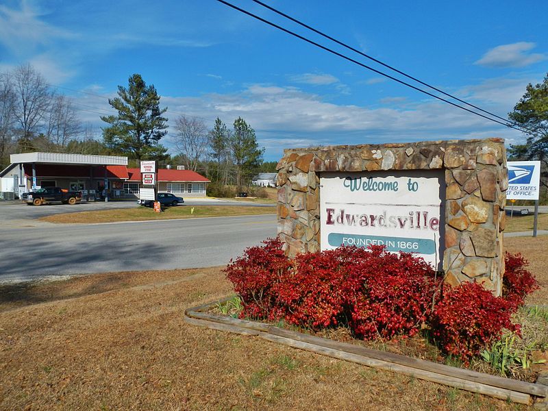
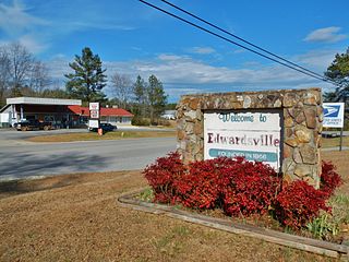
157:This is a photograph of Edwardsville, Alabama
8:
522:http://commons.wikimedia.org/User:SaveRivers
699:
293:– to copy, distribute and transmit the work
1187:
805:
407:
392:You may select the license of your choice.
882:The following other wikis use this file:
1624:
1616:
1608:
1600:
1592:
1584:
1576:
1568:
1560:
1550:
1540:
1530:
1522:
1514:
1506:
1495:
1485:
1477:
1469:
1461:
1453:
1443:
1435:
1425:
1417:
1407:
1399:
1389:
1381:
1360:
1352:
1341:
1333:
1325:
1317:
1307:
1299:
1291:
1283:
1275:
1267:
1259:
1248:
1240:
1229:
1219:
1209:
1199:
869:
779:
763:
723:
707:
679:
663:
645:
629:
609:
592:
576:
556:
540:
458:
442:
425:
422:
403:
396:
196:
225:View this and other nearby images on:
1189:
7:
372:http://www.gnu.org/copyleft/fdl.html
280:Attribution-Share Alike 3.0 Unported
794:
268:
263:
1180:
1166:Usage on zh-min-nan.wikipedia.org
416:
410:
391:
254:
250:
151:
134:
80:
415:
1594:Reference for direction of image
1573:94E4866BC0B249A1B08A7C93805CE524
1242:Date and time of data generation
710:coordinates of the point of view
401:
348:
347:
304:Under the following conditions:
275:This file is licensed under the
267:
262:
256:
231:
217:
209:
101:
31:
21:
1586:Satellites used for measurement
1313:COOLPIX AW100V1.0
398:
208:
152:
14:
725:33°42'27.119"N, 85°30'36.324"W
397:
378:GNU Free Documentation License
367:GNU Free Documentation License
357:GNU Free Documentation License
26:
1:
1466:A directly photographed image
682:original creation by uploader
166:Taken on 16 January 2012
36:
1280:308.2 meters above sea level
472:object of statement has role
423:Items portrayed in this file
1354:Date and time of digitizing
1056:Usage on mzn.wikipedia.org
1046:Usage on lld.wikipedia.org
926:Usage on ceb.wikipedia.org
906:Usage on azb.wikipedia.org
896:Usage on arz.wikipedia.org
1646:
1508:Focal length in 35 mm film
1437:Supported Flashpix version
1156:Usage on www.wikidata.org
1146:Usage on vi.wikipedia.org
1136:Usage on uz.wikipedia.org
1126:Usage on uk.wikipedia.org
1116:Usage on tt.wikipedia.org
1106:Usage on sr.wikipedia.org
1096:Usage on pt.wikipedia.org
1086:Usage on pl.wikipedia.org
1076:Usage on no.wikipedia.org
1066:Usage on nl.wikipedia.org
1036:Usage on it.wikipedia.org
1026:Usage on hu.wikipedia.org
1016:Usage on ht.wikipedia.org
1006:Usage on ga.wikipedia.org
996:Usage on fr.wikipedia.org
986:Usage on fa.wikipedia.org
976:Usage on eu.wikipedia.org
966:Usage on es.wikipedia.org
956:Usage on de.wikipedia.org
946:Usage on cy.wikipedia.org
936:Usage on ce.wikipedia.org
916:Usage on ca.wikipedia.org
886:Usage on ar.wikipedia.org
318:same or compatible license
1610:Geodetic survey data used
1362:Meaning of each component
1319:File change date and time
795:
174:
147:Edwardsville, Alabama.JPG
16:
400:
362:Free Software Foundation
284:
108:This is a file from the
1578:GPS time (atomic clock)
1471:Custom image processing
852:
180:
170:
165:
162:
144:
112:. Information from its
1562:Subject distance range
1383:Image compression mode
1357:12:57, 16 January 2012
1322:15:00, 17 January 2012
1245:12:57, 16 January 2012
1170:Edwardsville (Alabama)
1140:Edwardsville (Alabama)
1100:Edwardsville (Alabama)
1090:Edwardsville (Alabama)
1080:Edwardsville (Alabama)
1070:Edwardsville (Alabama)
1050:Edwardsville (Alabama)
1040:Edwardsville (Alabama)
1030:Edwardsville (Alabama)
1020:Edwardsville (Alabama)
1000:Edwardsville (Alabama)
980:Edwardsville (Alabama)
970:Edwardsville (Alabama)
960:Edwardsville (Alabama)
920:Edwardsville (Alabama)
831:21:43, 17 January 2012
237:33.707533; -85.510090
115:description page there
46:Size of this preview:
1401:Maximum land aperture
1293:Horizontal resolution
1150:Edwardsville, Alabama
1130:Едвардсвілл (Алабама)
1120:Эдвардсвилл (Алабама)
1010:Edwardsville, Alabama
950:Edwardsville, Alabama
940:Эдвардсвилл (Алабама)
872:Edwardsville, Alabama
1458:Digital still camera
1110:Едвардсвил (Алабама)
1060:ادواردزویل (آلاباما)
74:4,479 × 3,359 pixels
70:2,560 × 1,920 pixels
1327:Y and C positioning
1301:Vertical resolution
1191:Camera manufacturer
990:ادواردزویل، آلاباما
910:ادواردزویل، آلاباما
782:Nikon Coolpix AW100
299:– to adapt the work
52:Other resolutions:
1602:Direction of image
1516:Scene capture type
1492:Auto white balance
500:Wikimedia username
487:author name string
66:1,280 × 960 pixels
62:1,024 × 768 pixels
1633:
1632:
1404:3.9 APEX (f/3.86)
1216:1/500 sec (0.002)
878:Global file usage
860:
701:
579:copyright license
409:
389:
388:
242:
241:
191:
190:
130:
129:
110:Wikimedia Commons
32:Global file usage
1637:
1335:Exposure Program
1272:85° 30′ 36.32″ W
1264:33° 42′ 27.12″ N
1188:
843:
747:
746:
741:
543:copyright status
524:
519:
509:
504:
494:
491:
481:
476:
385:
382:
379:
376:
373:
351:
350:
344:
340:
337:
334:
331:
328:
320:as the original.
277:Creative Commons
271:
270:
266:
265:
260:
259:
238:
235:
221:
220:
214:
213:
212:
206:
205:
194:
184:Rivers Langley;
176:
156:
148:
142:
126:
105:
104:
98:
92:
90:
77:
58:640 × 480 pixels
54:320 × 240 pixels
48:800 × 600 pixels
1645:
1644:
1640:
1639:
1638:
1636:
1635:
1634:
1626:GPS tag version
1621:16 January 2012
1570:Unique image ID
1205:COOLPIX AW100
1176:
876:
868:
861:
849:
841:
797:
796:
793:
792:
791:
790:
789:
788:
787:
786:
784:
772:
771:
770:
768:
757:
756:
755:
754:
753:
752:
751:
750:
749:
748:
744:
742:
739:
730:
729:
728:
726:
716:
715:
714:
712:
693:
692:
691:
690:
689:
688:
687:
686:
684:
672:
671:
670:
668:
657:
656:
655:
654:
653:
652:
651:
650:
648:
647:16 January 2012
638:
637:
636:
634:
623:
622:
621:
620:
619:
618:
617:
616:
614:
603:
602:
601:
600:
599:
597:
585:
584:
583:
581:
570:
569:
568:
567:
566:
565:
564:
563:
561:
549:
548:
547:
545:
534:
533:
532:
531:
530:
529:
528:
527:
526:
525:
520:
517:
511:
510:
505:
502:
496:
495:
492:
489:
483:
482:
477:
474:
465:
464:
463:
461:
451:
450:
449:
447:
436:
435:
434:
433:
432:
430:
414:
413:
412:
395:
394:
393:
383:
380:
377:
374:
371:
342:
341:
338:
335:
332:
329:
326:
325:
283:
272:
253:
252:
247:
236:
210:
201:
200:
197:Camera location
192:
158:
146:
139:
132:
131:
120:
119:
118:is shown below.
94:
88:
86:
79:
78:
51:
12:
11:
5:
1643:
1641:
1631:
1630:
1627:
1623:
1622:
1619:
1615:
1614:
1611:
1607:
1606:
1603:
1599:
1598:
1597:True direction
1595:
1591:
1590:
1587:
1583:
1582:
1579:
1575:
1574:
1571:
1567:
1566:
1563:
1559:
1558:
1555:
1549:
1548:
1545:
1539:
1538:
1535:
1529:
1528:
1527:High gain down
1525:
1521:
1520:
1517:
1513:
1512:
1509:
1505:
1504:
1501:
1494:
1493:
1490:
1484:
1483:
1480:
1476:
1475:
1474:Normal process
1472:
1468:
1467:
1464:
1460:
1459:
1456:
1452:
1451:
1448:
1442:
1441:
1438:
1434:
1433:
1430:
1424:
1423:
1420:
1416:
1415:
1412:
1406:
1405:
1402:
1398:
1397:
1394:
1388:
1387:
1384:
1380:
1379:
1378:
1377:
1376:does not exist
1374:
1371:
1368:
1363:
1359:
1358:
1355:
1351:
1350:
1347:
1340:
1339:
1338:Normal program
1336:
1332:
1331:
1328:
1324:
1323:
1320:
1316:
1315:
1310:
1306:
1305:
1302:
1298:
1297:
1294:
1290:
1289:
1286:
1282:
1281:
1278:
1274:
1273:
1270:
1266:
1265:
1262:
1258:
1257:
1254:
1247:
1246:
1243:
1239:
1238:
1235:
1228:
1227:
1224:
1218:
1217:
1214:
1208:
1207:
1202:
1198:
1197:
1192:
1179:
1175:
1174:
1173:
1172:
1164:
1163:
1162:
1154:
1153:
1152:
1144:
1143:
1142:
1134:
1133:
1132:
1124:
1123:
1122:
1114:
1113:
1112:
1104:
1103:
1102:
1094:
1093:
1092:
1084:
1083:
1082:
1074:
1073:
1072:
1064:
1063:
1062:
1054:
1053:
1052:
1044:
1043:
1042:
1034:
1033:
1032:
1024:
1023:
1022:
1014:
1013:
1012:
1004:
1003:
1002:
994:
993:
992:
984:
983:
982:
974:
973:
972:
964:
963:
962:
954:
953:
952:
944:
943:
942:
934:
933:
932:
924:
923:
922:
914:
913:
912:
904:
903:
902:
894:
893:
892:
880:
879:
875:
874:
866:
865:
864:
859:
858:
851:
847:
844:
840:4,479 × 3,359
838:
833:
828:
824:
823:
820:
817:
814:
811:
808:
801:
800:
785:
780:
778:
777:
776:
775:
774:
773:
769:
764:
762:
761:
760:
759:
758:
735:
734:
733:
732:
731:
727:
724:
722:
721:
720:
719:
718:
717:
713:
708:
706:
705:
704:
703:
697:
685:
680:
678:
677:
676:
675:
674:
673:
669:
666:source of file
664:
662:
661:
660:
659:
658:
649:
646:
644:
643:
642:
641:
640:
639:
635:
630:
628:
627:
626:
625:
624:
615:
610:
608:
607:
606:
605:
604:
598:
593:
591:
590:
589:
588:
587:
586:
582:
577:
575:
574:
573:
572:
571:
562:
557:
555:
554:
553:
552:
551:
550:
546:
541:
539:
538:
537:
536:
535:
513:
512:
498:
497:
485:
484:
470:
469:
468:
467:
466:
462:
459:
457:
456:
455:
454:
453:
452:
448:
443:
441:
440:
439:
438:
437:
431:
426:
424:
421:
420:
419:
418:
417:
406:
405:
402:
399:
390:
387:
386:
352:
324:
323:
322:
321:
311:
302:
301:
300:
294:
287:You are free:
274:
273:
255:
249:
248:
246:
243:
240:
239:
229:
223:
198:
189:
188:
182:
178:
177:
172:
168:
167:
164:
160:
159:
149:
140:
138:
135:
133:
128:
127:
106:
96:
95:
45:
41:
40:
39:
34:
29:
24:
19:
13:
10:
9:
6:
4:
3:
2:
1642:
1628:
1625:
1620:
1617:
1612:
1609:
1604:
1601:
1596:
1593:
1588:
1585:
1580:
1577:
1572:
1569:
1564:
1561:
1556:
1554:
1551:
1546:
1544:
1541:
1536:
1534:
1531:
1526:
1524:Scene control
1523:
1518:
1515:
1510:
1507:
1502:
1499:
1496:
1491:
1489:
1488:White balance
1486:
1482:Auto exposure
1481:
1479:Exposure mode
1478:
1473:
1470:
1465:
1462:
1457:
1454:
1449:
1447:
1444:
1439:
1436:
1431:
1429:
1426:
1421:
1418:
1413:
1411:
1410:Metering mode
1408:
1403:
1400:
1395:
1393:
1392:Exposure bias
1390:
1385:
1382:
1375:
1372:
1369:
1366:
1365:
1364:
1361:
1356:
1353:
1348:
1345:
1342:
1337:
1334:
1329:
1326:
1321:
1318:
1314:
1311:
1309:Software used
1308:
1303:
1300:
1295:
1292:
1287:
1284:
1279:
1276:
1271:
1268:
1263:
1260:
1255:
1253:
1249:
1244:
1241:
1236:
1233:
1230:
1225:
1223:
1220:
1215:
1213:
1212:Exposure time
1210:
1206:
1203:
1200:
1196:
1193:
1190:
1186:
1183:
1177:
1171:
1168:
1167:
1165:
1161:
1158:
1157:
1155:
1151:
1148:
1147:
1145:
1141:
1138:
1137:
1135:
1131:
1128:
1127:
1125:
1121:
1118:
1117:
1115:
1111:
1108:
1107:
1105:
1101:
1098:
1097:
1095:
1091:
1088:
1087:
1085:
1081:
1078:
1077:
1075:
1071:
1068:
1067:
1065:
1061:
1058:
1057:
1055:
1051:
1048:
1047:
1045:
1041:
1038:
1037:
1035:
1031:
1028:
1027:
1025:
1021:
1018:
1017:
1015:
1011:
1008:
1007:
1005:
1001:
998:
997:
995:
991:
988:
987:
985:
981:
978:
977:
975:
971:
968:
967:
965:
961:
958:
957:
955:
951:
948:
947:
945:
941:
938:
937:
935:
931:
928:
927:
925:
921:
918:
917:
915:
911:
908:
907:
905:
901:
898:
897:
895:
891:
888:
887:
885:
884:
883:
877:
873:
870:
862:
856:
850:
845:
839:
837:
834:
832:
829:
826:
825:
821:
818:
815:
812:
809:
807:
806:
804:
798:
783:
767:
766:captured with
738:
711:
683:
667:
633:
613:
596:
580:
560:
544:
523:
516:
508:
501:
488:
480:
473:
446:
429:
369:
368:
363:
359:
358:
353:
346:
345:
330:CC BY-SA 3.0
319:
315:
312:
309:
306:
305:
303:
298:
295:
292:
289:
288:
286:
285:
281:
278:
261:
244:
234:
230:
228:
227:OpenStreetMap
224:
222:
204:
199:
195:
187:
183:
179:
173:
169:
161:
155:
150:
143:
136:
124:
117:
116:
111:
107:
100:
99:
93:
84:
83:Original file
75:
71:
67:
63:
59:
55:
49:
44:
38:
35:
33:
30:
28:
25:
23:
20:
18:
15:
1565:Distant view
1498:Digital zoom
1419:Light source
1252:focal length
1201:Camera model
1184:
1181:
881:
802:
799:File history
479:photographer
365:
355:
313:
307:
296:
290:
207:
153:
123:You can help
113:
81:
22:File history
1455:File source
1446:Color space
1285:Orientation
559:copyrighted
314:share alike
308:attribution
145:Description
1543:Saturation
1463:Scene type
900:ادواردسفيل
890:إدواردسفيل
863:File usage
855:SaveRivers
848:SaveRivers
816:Dimensions
507:SaveRivers
493:SaveRivers
460:some value
186:SaveRivers
89:image/jpeg
27:File usage
1613:WGS-84
1553:Sharpness
1519:Landscape
1269:Longitude
1232:ISO speed
842:(6.73 MB)
813:Thumbnail
810:Date/Time
632:inception
245:Licensing
154:English:
1618:GPS date
1533:Contrast
1330:Co-sited
1277:Altitude
1261:Latitude
1222:F-number
1178:Metadata
404:Captions
297:to remix
291:to share
282:license.
175:Own work
37:Metadata
1629:2.3.0.0
1422:Unknown
1414:Pattern
1346:version
1304:300 dpi
1296:300 dpi
827:current
822:Comment
743:334.16
737:heading
696:heading
445:creator
428:depicts
408:English
137:Summary
85:
1605:334.16
1557:Normal
1547:Normal
1537:Normal
1288:Normal
1234:rating
1160:Q67195
745:degree
700:degree
215:
181:Author
171:Source
1581:18:57
1511:28 mm
1500:ratio
1428:Flash
1250:Lens
1226:f/7.8
1195:NIKON
1450:sRGB
1344:Exif
1256:5 mm
819:User
384:true
381:true
375:GFDL
339:true
336:true
163:Date
17:File
1349:2.3
1237:125
515:URL
1589:04
1373:Cr
1370:Cb
740::
518::
503::
490::
475::
72:|
68:|
64:|
60:|
56:|
50:.
1503:0
1440:1
1396:0
1386:4
1367:Y
370:.
125:.
91:)
76:.
Text is available under the Creative Commons Attribution-ShareAlike License. Additional terms may apply.
