290:
228:
125:
117:
242:
139:
258:
296:
301:
67:
551:"}},"text\/plain":{"en":{"":"heading"}}},"{\"value\":{\"amount\":\"+315\",\"unit\":\"http:\\\/\\\/www.wikidata.org\\\/entity\\\/Q28390\"},\"type\":\"quantity\"}":{"text\/html":{"en":{"P7787":"315
547:
348:– You must give appropriate credit, provide a link to the license, and indicate if changes were made. You may do so in any reasonable manner, but not in any way that suggests the licensor endorses you or your use.
108:
219:
38:
548:
197:
78:
46:
500:
464:
235:
132:
428:
265:
355:
618:
589:
562:
448:
520:
484:
412:
252:
771:
751:
311:
761:
714:
The following pages on the
English Knowledge (XXG) use this file (pages on other projects are not listed):
354:– If you remix, transform, or build upon the material, you must distribute your contributions under the
272:
on the
Geograph website for the photographer's contact details. The copyright on this image is owned by
791:
308:
555:"}},"text\/plain":{"en":{"P7787":"315 degree"}}}}": -->
86:
741:
686:
681:
37:
241:
138:
277:
73:
723:
225:
122:
168:
697:
178:
257:
269:
654:
Click on a date/time to view the file as it appeared at that time.
718:
611:
227:
124:
220:
55° 01′ 06.52″ N, 7° 17′ 32.91″ W
109:
55° 00′ 51.73″ N, 7° 17′ 18.21″ W
210:
99:
61:
396:
Add a one-line explanation of what this file represents
781:
150:
85:
Commons is a freely licensed media file repository.
501:
Creative
Commons Attribution-ShareAlike 2.0 Generic
51:(640 × 218 pixels, file size: 51 KB, MIME type:
365:https://creativecommons.org/licenses/by-sa/2.0
66:
371:Creative Commons Attribution-Share Alike 2.0
289:
8:
552:
331:– to copy, distribute and transmit the work
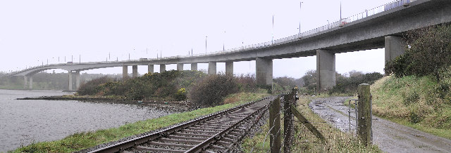
160:Foyle Bridge, Londonderry, from underneath.
656:
392:
734:The following other wikis use this file:
179:https://www.geograph.org.uk/photo/108464
716:
632:
616:
576:
560:
534:
518:
498:
482:
462:
446:
426:
410:
407:
388:
381:
213:
102:
234:View this and other nearby images on:
131:View this and other nearby images on:
7:
276:and is licensed for reuse under the
645:
312:Attribution-Share Alike 2.0 Generic
300:
295:
280:Attribution-ShareAlike 2.0 license.
401:
395:
286:
263:
98:
44:
400:
563:coordinates of the point of view
386:
342:Under the following conditions:
307:This file is licensed under the
299:
294:
288:
256:
240:
226:
137:
123:
115:
65:
31:
21:
383:
41:No higher resolution available.
14:
382:
264:This image was taken from the
26:
1:
619:coordinates of depicted place
578:55°0'51.732"N, 7°17'18.208"W
408:Items portrayed in this file
114:
738:Usage on azb.wikipedia.org
634:55°1'6.521"N, 7°17'32.910"W
810:
788:Usage on zh.wikipedia.org
778:Usage on www.wikidata.org
768:Usage on ru.wikipedia.org
758:Usage on ja.wikipedia.org
748:Usage on hy.wikipedia.org
356:same or compatible license
156:Foyle bridge, railside.jpg
47:Foyle_bridge,_railside.jpg
646:
16:
385:
322:
72:This is a file from the
703:
192:
184:
174:
167:
164:
153:
76:. Information from its
270:this photograph's page
246:55.018478; -7.292475
143:55.014370; -7.288391
79:description page there
682:17:37, 14 July 2006
337:– to adapt the work
730:Global file usage
707:
554:
485:copyright license
394:
285:
284:
268:collection. See
251:
250:
208:
207:
201:
198:Reusing this file
148:
147:
94:
93:
74:Wikimedia Commons
32:Global file usage
801:
694:
600:
599:
594:
449:copyright status
378:
375:
372:
369:
366:
358:as the original.
320:
309:Creative Commons
303:
302:
298:
297:
292:
291:
278:Creative Commons
266:Geograph project
260:
253:
247:
244:
230:
229:
223:
222:
211:
195:
170:
157:
151:
144:
141:
127:
126:
120:
119:
118:
112:
111:
100:
90:
69:
68:
62:
56:
54:
809:
808:
804:
803:
802:
800:
799:
798:
728:
715:
708:
700:
692:
648:
647:
644:
643:
642:
641:
640:
639:
638:
637:
635:
625:
624:
623:
621:
610:
609:
608:
607:
606:
605:
604:
603:
602:
601:
597:
595:
592:
583:
582:
581:
579:
569:
568:
567:
565:
546:
545:
544:
543:
542:
541:
540:
539:
537:
536:18 January 2006
527:
526:
525:
523:
512:
511:
510:
509:
508:
507:
506:
505:
503:
491:
490:
489:
487:
476:
475:
474:
473:
472:
471:
470:
469:
467:
455:
454:
453:
451:
440:
439:
438:
437:
436:
435:
434:
433:
431:
419:
418:
417:
415:
399:
398:
397:
380:
379:
376:
373:
370:
367:
364:
363:
321:
318:
315:
304:
281:
245:
218:
217:
214:Object location
209:
169:18 January 2006
155:
142:
116:
107:
106:
103:Camera location
96:
95:
84:
83:
82:is shown below.
58:
52:
50:
43:
42:
12:
11:
5:
807:
805:
797:
796:
795:
794:
786:
785:
784:
776:
775:
774:
766:
765:
764:
756:
755:
754:
746:
745:
744:
732:
731:
727:
726:
721:
713:
712:
711:
706:
705:
702:
698:
695:
689:
684:
679:
675:
674:
671:
668:
665:
662:
659:
652:
651:
636:
633:
631:
630:
629:
628:
627:
626:
622:
617:
615:
614:
613:
612:
588:
587:
586:
585:
584:
580:
577:
575:
574:
573:
572:
571:
570:
566:
561:
559:
558:
557:
556:
550:
538:
535:
533:
532:
531:
530:
529:
528:
524:
519:
517:
516:
515:
514:
513:
504:
499:
497:
496:
495:
494:
493:
492:
488:
483:
481:
480:
479:
478:
477:
468:
463:
461:
460:
459:
458:
457:
456:
452:
447:
445:
444:
443:
442:
441:
432:
427:
425:
424:
423:
422:
421:
420:
416:
411:
409:
406:
405:
404:
403:
402:
391:
390:
387:
384:
362:
361:
360:
359:
349:
340:
339:
338:
332:
325:You are free:
316:
306:
305:
287:
283:
282:
261:
249:
248:
238:
232:
215:
206:
205:
202:
190:
189:
186:
182:
181:
176:
172:
171:
166:
162:
161:
158:
149:
146:
145:
135:
129:
104:
97:
92:
91:
70:
60:
59:
40:
36:
35:
34:
29:
24:
19:
13:
10:
9:
6:
4:
3:
2:
806:
793:
790:
789:
787:
783:
780:
779:
777:
773:
770:
769:
767:
763:
760:
759:
757:
753:
750:
749:
747:
743:
740:
739:
737:
736:
735:
729:
725:
722:
720:
717:
709:
701:
696:
690:
688:
685:
683:
680:
677:
676:
672:
669:
666:
663:
660:
658:
657:
655:
649:
620:
591:
564:
522:
502:
486:
466:
450:
430:
414:
368:CC BY-SA 2.0
357:
353:
350:
347:
344:
343:
341:
336:
333:
330:
327:
326:
324:
323:
319:Kenneth Allen
317:Attribution:
313:
310:
293:
279:
275:
274:Kenneth Allen
271:
267:
262:
259:
255:
254:
243:
239:
237:
236:OpenStreetMap
233:
231:
221:
216:
212:
203:
199:
194:
191:
188:Kenneth Allen
187:
183:
180:
177:
173:
163:
159:
152:
140:
136:
134:
133:OpenStreetMap
130:
128:
110:
105:
101:
88:
81:
80:
75:
71:
64:
63:
57:
48:
39:
33:
30:
28:
25:
23:
20:
18:
15:
733:
724:Foyle Bridge
653:
650:File history
429:Foyle Bridge
351:
345:
334:
328:
273:
204:cc-by-sa-2.0
113:
87:You can help
77:
45:
22:File history
772:Лондондерри
752:Լոնդոնդերրի
465:copyrighted
352:share alike
346:attribution
154:Description
742:راس-آن-وای
710:File usage
691:640 × 218
667:Dimensions
193:Permission
53:image/jpeg
27:File usage
792:德里 (北愛爾蘭)
664:Thumbnail
661:Date/Time
521:inception
782:Q5477382
389:Captions
335:to remix
329:to share
314:license.
762:ロンドンデリー
693:(51 KB)
678:current
673:Comment
590:heading
549:heading
413:depicts
393:English
49:
598:degree
553:degree
224:
185:Author
175:Source
121:
719:Derry
699:GeeJo
670:User
596:315
377:true
374:true
165:Date
17:File
593::
200:)
196:(
89:.
55:)
Text is available under the Creative Commons Attribution-ShareAlike License. Additional terms may apply.
